desperado, the pacificBiblio.com

6 260 résultats
1949756289.Gpaperback. Good. Access codes and supplements are not guaranteed with used items. May be an ex-library book. paperback
191264223Portland OR: American Map and Reproducing Company Corner E. Stark & E. 43rd 1912. One double atlas folio colour lithograph map sized 28 x 40.5 professionally mounted on archival linen sized 32 x 45 in. w/ scale of 1:24000 minor edgewear slight age toning at fore-edges and lower corner still a VG bright copy. First edition of this very uncommon Progressive Era map of Portland Oregon in the years between the Lewis & Clark Centennial Exposition and World War I. The map depicts public lands including township range and section grids along with neighborhood and addition place names steam & electric interurban railroads and electric streetcar lines along with parks city limits and radial distances from point in downtown Portland included. Place names included Zion Town the old steel bridge built in 1888 followed by a new Steel bridge which opened later in 1912 the Plank/Old Canyon Road Laurelhurst and others. Of particular interest beyond most maps of Portland during the era this map delineates a significant portion of Vancouver Washington prior to the construction of the Interstate Bridge across Hayden Island as well as inroads into portions of Northwest Portland and Washington County in the Southwest. Fritsche 1877-1928 was an intrepid German-American photo-lithographer architect printer and later photographer who first arrived in New York before coming West to the Pacific Northwest in 1907 where he set up an architecture and engraving firm with his brother Rudolph Fritsche. Wenzel is perhaps best remembered as architect of the historic Henry C. & Wilhemina Bruening House Craftsman bungalow located at 5919 North Williams in Portland’s Humboldt neighborhood erected in 1910. However by 1914 Wenzel had returned to Manhattan with his family including one son and three daughters. Worldcat locates 5 copies U of IL Boston Pub. OHS Reed U of O. American Map and Reproducing Company, [Corner E. Stark & E. 43rd], unknown
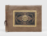
1940182459Manila: 1940s. A graphic album showing fighting in the Philippines the Marshall Islands Papua New Guinea Guam the Solomon Islands and Palau. The compiler chose to include violent images displaying the brutality of the campaign. The album opens with portrait shots of individual Marines or groups along with photographs of American encampments and ships. The scenes then turn more distressing with images of dead locals including children lying on the beach or next to tanks. The photographs were taken across the Pacific theatre: one shows an American soldier holding a flame-thrower on Kwajalein Atoll another shows a beach landing at Luzon and a third shows a Marine posing next to a sign in Bougainville. Most were taken in the final years of the conflict including at Guadalcanal and Peleliu. There are also shots of the end of the war one showing a Japanese soldier surrendering with a white flag and another showing Japanese prisoners of war in a camp in Guam. The final photograph is the most famous "Raising the Flag on Iwo Jima" showing six Marines raising the US flag on Mount Suribachi during the Battle of Iwo Jima. This photograph won the 1945 Pulitzer Prize for Photography. The majority of the photographs are commercial with a few opening portrait shots of the unidentified compiler. Oblong folio 286 x 390 mm. With 55 gelatin silver photographs one lacking approximately 90 x 130 mm landscape or portrait corner-mounted with tape recto and verso on 7 leaves remainder blank. With 2 additional gelatin silver photographs loosely inserted. Contemporary brown sheep commercial album tied through punched holes with brown cord front board stamped with central armourial panel in blind gilt and black. Boards chipped at extremities especially front board bottom left corner rear board rubbed leaves nicked at fore edge photographs moderately toned and creased some slightly torn and abraded: a good example. hardcover
1332099017.Gpaperback. Good. Access codes and supplements are not guaranteed with used items. May be an ex-library book. paperback
0332162230.Ghardcover. Good. Access codes and supplements are not guaranteed with used items. May be an ex-library book. hardcover
200025757San Francisco CA: Pacific Book Auction Galleries /PBA Galleries. New. 2000. Paperback. FREE UPGRADE to Courier/Priority Shipping Upon Request - IN STOCK AND IMMEDIATELY AVAILABLE FOR SHIPMENT - FLAWLESS COPY BRAND NEW PRISTINE NEVER OPENED -- with a bonus offer-- . Pacific Book Auction Galleries /PBA Galleries paperback
(Codice VS/0444) In 4° (cm 36) 392 pp. Grande splendida volume, illustrato con moltissime foto e carte in gran parte a colori. Pregiata edizione, stampa a cura di De Agostini, su carta distinta, tiratura limitata numerata. Con bibliografia, indici dei nomi geografici e delle carte. Grande e bel volume, elegante legatura similpelle originale blu, con titolo e fregi oro. Freschissimo, come nuovo nel cofanetto editoriale. ~~~ SPEDIZIONE IN ITALIA SEMPRE TRACCIATA
Light shelfwear and chips to DJ ; Oblong 8vo 8" to 9" tall; 128 pages
243 pages. Tissue-protected frontis photo portrait of author. Attractively decorated maroon cloth-covered front board. All seventeen black and white plates present. "An autobiographical account of the author's first twelve years (from 1862 to September 1873) as a Methodist missionary among the Cowichan and Nanaimo Indians." - Lowther. Average wear. Prior owner's name in light pencil upon front free endpaper. Faint moisture marks to fore-edge of first twenty-five pages. Hinges starting. Issued without dust jacket. LOWTHER 1556, RICKS p.75, AMTMANN 3499, SMITH 2134, WALLACE p.52, MATTHEWS 295, TOD & CORDINGLEY p.85. Book
1949VR174591949 xiv, 236 p., 20 figs, 54 pls, col. frontispiece, cloth. Library stamp.
1909VZ221171909 46 p., 34 figs (maps), disbound (no covers). Published in: Proceedings of the Zoological Society of London.
178915818Tourneisen Bâle 1789 1 vol. In-8 de XVI 381 pp., pleine basane fauve de l'époque, dos lisse fileté, pièce de titre, tranches rouges.
Sm. folio, single leaf, fine woodblock arms of Victoria at head; a very good, crisp, clrean copy ideal for framing and display. 26 Victoriae, Cap. 23, granted Royal Assent 8 June 1863.
8vo. 6 pages, plus 2 large folding diagrams. A rare separate offprint printed for the Royal Geographical Society. Publisher's blue titled wrappers, string-tied and bearing the society's crest. Some light foxing, otherwise in very good and original condition. The author, a respected astronomer and well-known authority on comets, renders praise to the primary research and calculations of Major S.C.N. Grant in 1896, which forms the basis for his dissertation. With meticulous and detailed instruction Crommelin presents a simplified method to predict and decipher the instantaneous and momentary occultation of stars which greatly simplifies the detremination of Longitude at Sea. He further introduces the application to the Solar Eclipse phenomenon. Exceedingly rare dissertation by an important nineteenth century astronomer. Six years prior to Crommelin's study, Grant published a six page report and illustration, titled "Diagram for Determining the Parallaxes in Declination and Right Ascension of a Heavenly Body, and its Application to the Prediction of Occultations." Crommelin was famed for his computations of cometary orbits. He took part in expeditions to observe total solar eclipses in 1896, 1900, 1905, 1912, and 1927. In 1919 he participated in the solar eclipse expedition to Brazil which aimed to determine the amount of the deflection of light caused by the gravitational field of the Sun. The results from these observations were crucial in providing confirmation of the General Theory of Relativity, which Albert Einstein had proposed in 1916.
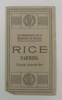
19002733Houston: Southern Pacific Sunset Route 1900. Very good. 4pp. on a single folded sheet. Minor toning and creasing. A simple but still interesting promotional leaflet touting the advantages of rice farming in Texas. The text was taken from the Southern Pacific Rice Book and lists twenty-six points of advice about the rice industry and how it is a good investment. These points are listed alphabetically by letter and each entry begins with that letter. For example: "H. Harvest rice same as wheat using a rice harvester." OCLC records just a single copy at the Autry Museum. Southern Pacific Sunset Route unknown
1990201740Broadbeach QLD. Pacific Books. 1990. 4to. Or.cloth-backed boards. 317274256230pp. With fold-out maps. Fine set. Originally published in 1944-45. The set Volume 3. Malaya Thailand Indo China the China Coast and the Japanese Empire. Volume 4. With an introduction by General Douglas MacArthur United States Army Broadbeach, QLD. Pacific Books. hardcover
33310N.p Facsimile reprint of the 1944 edition. 4 Vols. 4to 317; 274; 256; 230pp. orig. cloth-backed boards. Volume I: The Netherlands and British East Indies and the Philippine Islands. Volume II: The Mandated Territory of New Guinea Papua the British Solomon Islands the New Hebrides and Micronesia. Volume III: Malaya Thailand Indo China the China Coast and the Japanese Empire. Volume IV: Supplement to volumes 1 2 & 3. [N.p], (Facsimile reprint of the 1944 edition) hardcover
31901N.p Facsimile reprint of the 1944 edition. 3 Vols. 4to 317; 274; 230pp. orig. cloth-backed boards. Volume I: The Netherlands and British East Indies and the Philippine Islands. Volume II: The Mandated Territory of New Guinea Papua the British Solomon Islands the New Hebrides and Micronesia. Volume IV: Supplement to volumes 1 2 & 3. [N.p], (Facsimile reprint of the 1944 edition) hardcover
1396662456.Ghardcover. Good. Access codes and supplements are not guaranteed with used items. May be an ex-library book. hardcover
1391605772.Gpaperback. Good. Access codes and supplements are not guaranteed with used items. May be an ex-library book. paperback
18781206699Sydney, Th. Richards, 1878. Gr.-8vo. Titel, 16, 173 S., 1 zweifarb. lithograph., mehrfach gefaltetes Panorama (ca 23,5 x 168,5 cm), 1 mehrfach gefaltete Tabelle. Hlwdbd d. Zeit (etwas beschabt m. einer kl. Fehlstelle im Bezug, Stempel auf Titel, Panorama an zwei Faltstellen hinterlegt u. dort mit wenigen kleinen, teils nachgefärbten Fehlstellen, ohne die Faltkarte).
21 pages. Plus a large fold-out colour map measuring approximately 8.5 x 23 inches (22 x 59cm). Original condition with blue wrappers, titles to front, and containing all the ads. This is a complete issue, seldom found in such good and original condition. David Lindsay was an Australian explorer and surveyor and a fellow of the Royal Geographical Society. This is an abridged account of his important journey across Australia in 1885-6, in which he passed through a large tract of previously unexplored country in the Northern Territory of South Australia, west of the Queensland boundary. This valuable and absorbing account describes his expedition of the Finke River and excursion to the western boundary of Queensland, also includes an extensive chronological report of his journey from Dalhousie to the Gulf of Carpentaria. Accompanied by a spectacular fold-out colour map illustrating the explorations and surveys in the northern territories of South Australia. The map stretches from the Gulf of Carpentaria in the north to the Truer or Macumba in the south, showing Lindsay's track, survey lines, and telegraph lines. Also included is an impressive Vocabulary list, containing some important native words with their English translations.
1999BA454401999 v, 166 p., 139 figures (photographs), 4to, paperbound. Very good copy.
A clean, unmarked book with a tight binding. Previous owner's name on front endpaper. 414 pages. 5"w x 7 1/2"h. A guide to Pacific Coast trees with a key to genera, glossary of botancial terms, list of trees for various uses, index of species by common and scientific names. Many b&w illustrations.
1983ED444651983 493 p., 4 plates depicting 16 portraits, hardbound. Library stamps, else a very good copy.