12 035 résultats
1 27x19.5 cm., XVI, 336 pp., numerose ill. n.t., alcune a piena pagina, legatura edit. in tela a 2 colori, prima edizione, cerniere un po' allentare e piccolo strappo al dorso senza mancanze, buon esemplare Dettagliato resoconto del viaggio di Mrs. Gardner, arricchito da numerose illustrazioni raffiguranti paesaggi e personaggi dell'India settentrionale.
189757629Delhi u. Dehradun, Periodical Expert Book Agency u. International Book Distributors, 1978 (Nachdruck der Ausgabe 1872-1897). 8°. Zus. ca. 5.500 S., OLwd.-Bde.
22108Londres, Saunders, Otley and Co., 1863. In-4, IV-367 pp., percaline verte de l'éditeur, plats estampés à froid, dos long doré (percaline défraîchie, quelques minuscules déchirures marginales sans atteinte, pp. 231 à 234 débrochées)
8vo., First Edition, on laid paper, with 4 full-page maps coloured in outline and 2 large folding coloured maps; handsomely bound in burgundy full morocco, back gilt with five raised bands, second and fourth compartments lettered and ruled in gilt, all other compartments tooled and ruled in gilt, a most attractive copy ideal as a gift or for presentation.
Photographs showing the homes of people who live in poverty in Nairobi, Kenya; Mumbai, India; Jakarta, Indonesia; and Crarcas, Venzuela by Norwegian photojournalist Jonas Bediksen. Pictorial cover. 8 1/8"w x 6 1/8"h. The pages fold-out to be 32 1/2" long, when open. Photographs alternate with autobiographical text by the people depicted. One gate folded page shows a slight crease where it folds into the center of the book.
Extremely light rubbing to outer spine hinges and to top and bottom spine. Else NF; An outstandingly beautiful set. Decorative sandy boards with gilt lettering and pictorial design in color. Marbled edges. Handsome endpapers with green design. Numerous plates from photographs. Index. Both volumes with rear fold-out map in color; 8vo; 456, 403 pages
2 voll. in 8°, broch. muta coeva, stanca, pp 395, 454, 1 ritratto all'antiporta ed altre cinque tavv. rip. f.t. (carte geogr. incise in rame, un'acquatinta e una veduta). Prima edizione di significativa opera dell'A. che ebbe celebrità per la storia delle crociate. Contiene la tragica storia dei sovrani di Mysore nella guerra contro gli inglesi ed altri stati dell'india; un rapporto sulla conquista napoleonica in Egitto in relazione all'India; le lettere di Bonaparte a Tippoo Saib. Parla inoltre delle religioni, dei costumi e della legislazione indiana e delle relazioni commerciali e politiche con l'Europa. Esemplare genuino, in barbe.
1768A2647Amsterdam, Arkstee & Merkus, 1768 ; in-8, XXVIII pp. + 208 pp. + 4 planches dépliantes, relié plein-veau d'époque, dos lisse orné. (Reliure état moyen, plats frottes, mors fragile). John Zephaniah Holwell (1711-1798) chirurgien anglais contacté par la Compagnie orientale des Indes, puis gouverneur temporaire du Bengale (1760) édita à Londres, de 1765 à 1771, trois volumes de Interesting Historical Events Relative to the Provinces of Bengal and the Empire of Indostan, with a seasonable hint and perswasive to the honourable the court of directors of the East India Company. As also the mythology and cosmogony, fasts and festivals of the Gentoo's, followers of the Shastah. And a dissertation on the metempsychosis, commonly, though erroneously, called the Pythagorean doctrine, dont nous proposons une traduction ici. L’ouvrage fournit des témoignages intéressants concernant l'hindouisme. Bon état.
Amsterdam, Arkstee & Merkus, 1768; in-8, XXVIII pp. + 208 pp. + 4 planches dépliantes, relié plein-veau d'époque, dos lisse orné. (Reliure état moyen, plats frottes, mors fragile). John Zephaniah Holwell (1711-1798) chirurgien anglais contacté par la Compagnie orientale des Indes, puis gouverneur temporaire du Bengale (1760) édita à Londres, de 1765 à 1771, trois volumes de Interesting Historical Events Relative to the Provinces of Bengal and the Empire of Indostan, with a seasonable hint and perswasive to the honourable the court of directors of the East India Company. As also the mythology and cosmogony, fasts and festivals of the Gentoo's, followers of the Shastah. And a dissertation on the metempsychosis, commonly, though erroneously, called the Pythagorean doctrine, dont nous proposons une traduction ici. L’ouvrage fournit des témoignages intéressants concernant l'hindouisme. Bon état.
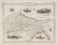
1851200119AG1851. London & New York John Tallis & Company 1851. Original steel engraving / Vintage map. Drawn and engraved by John Rapkin. Partly hand-coloured. Illustrations by A.H. Wray and Engraved by J.H. Kernot. Plate Size: 31.5 cm x 25 cm. Sheet Size: 37.2 cm x 27.2 cm. Vintage 19th century map in very good condition. Beautifully bordered map of northern India from Cambay to Chittagong and Aracan in the Bay of Bengal. The political subdivisions are colourfully included marking out independent Nepal and Bhutan. The regions of Jemer Malwa Allahabade and Assam can also be seen on the map along with the names of many towns and cities The regions rivers including the Ganges are shown and relief is depicted with hachuring. John Tallis 7 November 1817 3 June 1876 was an English cartographic publisher. His company John Tallis and Company published views maps and atlases in London from roughly 1838 to 1851. Tallis set up as a publisher with Frederick Tallis in Cripplegate in 1842; the business moved to Smithfield in 1846 and was dissolved in 1849. From 1851 to 1854 Tallis operated as John Tallis and Company. He started The illustrated news of the world and national portrait gallery of eminent personages in 1858 selling it for £1370 in 1861; it folded in 1863. Wikipedia The most important project John Tallis undertook was the 'Illustrated Atlas' from 1851. The original map we offer here was part of this exceptional Atlas and all the maps it contained are still today considered as the last reminder of an era of lavish map production. Tallis worked the project together with John Rapkin 1815-1876 and it was Rapkin's style and talent that we have to thank for when we marvel at these maps today. What makes these maps so special is the detail of engraved vignettes that surround the map and often show indigenous scenes people in their environment and even more so historical buildings or historical views of towns and cities architecture and landscape. The project of 'The Illustrated Atlas' was designed to be finished just in time for the anxiously awaited "Great Exhibition of the Works of Industry of All Nations" or The Great Exhibition sometimes referred to as the Crystal Palace Exhibition in reference to the temporary structure in which it was held was an international exhibition that took place in Hyde Park London from 1 May to 11 October 1851. It was the first in a series of World's Fairs exhibitions of culture and industry that became popular in the 19th century and it was a much anticipated event. The Great Exhibition was organized by Henry Cole and Prince Albert husband of the reigning monarch Queen Victoria. It was attended by numerous notable figures of the time including Charles Darwin Samuel Colt members of the Orléanist Royal Family and the writers Charlotte Brontë Charles Dickens Lewis Carroll George Eliot and Alfred Tennyson. Music for the opening was under the direction of Sir George Thomas Smart and the continuous music from the exhibited organs for the Queen's procession was "under the superintendence of William Sterndale Bennett". Wikipedia unknown
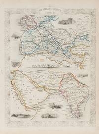
1851200124AG1851. London & New York John Tallis & Company 1851. Original steel engraving / Vintage map. Drawn and engraved by John Rapkin. Partly hand-coloured. Illustrations by H. Warren and Engraved by J. Rogers. Plate Size: 34.5 cm x 34 cm. Sheet Size: 27.2 cm x 37.4 cm. Vintage 19th century map in very good condition. Published in the Illustrated Atlas And Modern History Of The World Geographical Political Commercial & Statistical Edited By R. Montgomery Martin. Beautifully bordered and fascinating double map of the overland route between Britain and India. The upper map shows Europe and the links - both land and sea - running from England through to Alexandria Egypt. The routes are; the 'Mail Steam Packet Route' which runs around Gibraltar through Malta and onto Egypt; the 'Marseilles Overland Route' that runs across France to Marseilles and onto Alexandria via Malta and; the 'German Overland Route' that runs through across Belgium Germany before reaching Trieste and then onto the Mediterranean and then Egypt. The second map shows the differing routes on the next part of the journey - either across the Turkish controlled Middle East and through the Persian Gulf or down the Red Sea and across the Indian Ocean. What the map clearly illustrates is the importance attached to India 'Hindoostan' in the Imperial mind and the need for secure communication and transport links which necessitated control of certain choke points on the link such as Gibraltar Malta Suez etc. John Tallis 7 November 1817 3 June 1876 was an English cartographic publisher. His company John Tallis and Company published views maps and atlases in London from roughly 1838 to 1851. Tallis set up as a publisher with Frederick Tallis in Cripplegate in 1842; the business moved to Smithfield in 1846 and was dissolved in 1849. From 1851 to 1854 Tallis operated as John Tallis and Company. He started The illustrated news of the world and national portrait gallery of eminent personages in 1858 selling it for £1370 in 1861; it folded in 1863. Wikipedia The most important project John Tallis undertook was the 'Illustrated Atlas' from 1851. The original map we offer here was part of this exceptional Atlas and all the maps it contained are still today considered as the last reminder of an era of lavish map production. Tallis worked the project together with John Rapkin 1815-1876 and it was Rapkin's style and talent that we have to thank for when we marvel at these maps today. What makes these maps so special is the detail of engraved vignettes that surround the map and often show indigenous scenes people in their environment and even more so historical buildings or historical views of towns and cities architecture and landscape. The project of 'The Illustrated Atlas' was designed to be finished just in time for the anxiously awaited "Great Exhibition of the Works of Industry of All Nations" or The Great Exhibition sometimes referred to as the Crystal Palace Exhibition in reference to the temporary structure in which it was held was an international exhibition that took place in Hyde Park London from 1 May to 11 October 1851. It was the first in a series of World's Fairs exhibitions of culture and industry that became popular in the 19th century and it was a much-anticipated event. The Great Exhibition was organized by Henry Cole and Prince Albert husband of the reigning monarch Queen Victoria. It was attended by numerous notable figures of the time including Charles Darwin Samuel Colt members of the Orléanist Royal Family and the writers Charlotte Brontë Charles Dickens Lewis Carroll George Eliot and Alfred Tennyson. Music for the opening was under the direction of Sir George Thomas Smart and the continuous music from the exhibited organs for the Queen's procession was "under the superintendence of William Sterndale Bennett". Wikipedia unknown
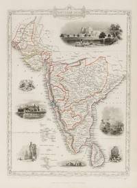
1851200109AG1851. London & New York John Tallis & Company 1851. Original steel engraving / Vintage map. Drawn and engraved by John Rapkin. Partly hand-coloured. Illustrations by A.H. Wray and Engraved by J.H. Kernot. Plate Size: 31.8 cm x 25.5 cm. Sheet Size: 37.2 cm x 27.2 cm. Vintage 19th century map in very good condition. Beautiful map of the southern Indian subcontinent from Sinde at the mouth of the Indus Estuary in the north down through Gujerat Bejapor and Mysore and down into the Carnatic region in the south. Hydrabad and Circars border the Bay of Bengal. Ceylon is also included in the map as are the Laccadive and Maldive islands in the Indian Ocean. Relief is depicting with hachuring. The major cities such as Bombay Sernigapatam and Madras are shown as are the rivers - including the Godavery and Beema rivers. This was an India dominated by the East India Company the British joint-stock company that came to rule large areas of India with its private armies exercising military power and seizing administrative functions. Formed in the early 1600s to compete with the Dutch for trade and commerce in the East the company rose to account for half of the world's trade at one point. Company rule in India lasted until 1858 when following the Indian Rebellion of 1857 the Government of India Act 1858 led to the British Crown's assuming direct control of the Indian subcontinent in the form of the new British Raj. The company was dissolved in 1874 as a result of the East India Stock Dividend Redemption Act passed one year earlier as the Government of India Act had by then rendered it vestigial powerless and obsolete. The official government machinery of British India assumed the East India Company's governmental functions and absorbed its navy and its armies in 1858. Wikipedia John Tallis 7 November 1817 3 June 1876 was an English cartographic publisher. His company John Tallis and Company published views maps and atlases in London from roughly 1838 to 1851. Tallis set up as a publisher with Frederick Tallis in Cripplegate in 1842; the business moved to Smithfield in 1846 and was dissolved in 1849. From 1851 to 1854 Tallis operated as John Tallis and Company. He started The illustrated news of the world and national portrait gallery of eminent personages in 1858 selling it for £1370 in 1861; it folded in 1863. Wikipedia The most important project John Tallis undertook was the 'Illustrated Atlas' from 1851. The original map we offer here was part of this exceptional Atlas and all the maps it contained are still today considered as the last reminder of an era of lavish map production. Tallis worked the project together with John Rapkin 1815-1876 and it was Rapkin's style and talent that we have to thank for when we marvel at these maps today. What makes these maps so special is the detail of engraved vignettes that surround the map and often show indigenous scenes people in their environment and even more so historical buildings or historical views of towns and cities architecture and landscape. The project of 'The Illustrated Atlas' was designed to be finished just in time for the anxiously awaited "Great Exhibition of the Works of Industry of All Nations" or The Great Exhibition sometimes referred to as the Crystal Palace Exhibition in reference to the temporary structure in which it was held was an international exhibition that took place in Hyde Park London from 1 May to 11 October 1851. It was the first in a series of World's Fairs exhibitions of culture and industry that became popular in the 19th century and it was a much anticipated event. The Great Exhibition was organized by Henry Cole and Prince Albert husband of the reigning monarch Queen Victoria. It was attended by numerous notable figures of the time including Charles Darwin Samuel Colt members of the Orléanist Royal Family and the writers Charlotte Brontë Charles Dickens Lewis Carroll George Eliot and Alfred Tennyson. Music for the opening was under the direction of Sir George Thomas Smart and the continuous music from the exhibited organs for the Queen's procession was "under the superintendence of William Sterndale Bennett". Wikipedia unknown
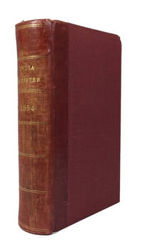
185484658London: Wm. H. Allen & Co 1854. Hardcover. Very Good. index c 145p. plus 6p. advertisements. Rebound in a red 20th century quarterbinding red leather backstrip and red cloth. 17cm. Rear joint tender. Richard F. Burton shows up in the list as does John H. Speke. Wm. H. Allen & Co hardcover
2000Star-9783790812688Springer 2000. Hardcover. New. Springer hardcover
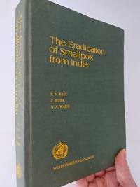
19793313New Delhi: World Health Organisation 1979. 1st Edition. Hardcover. Used - Very Good. Very good condition. Spine binding and cover all fine though corners turning slightly. Contents unmarked and no inscription; title on spine fading slightly but fine on front cover. Overall very good condition. 346 pages. World Health Organisation hardcover
2026x-1032702826Taylor & Francis Ltd 2026. Hardcover. New. 300 pages. 9.68x6.87x9.61 inches. Taylor & Francis Ltd hardcover
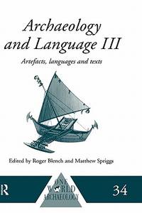
1999x-0415100542Routledge 1999. Hardcover. New. 1st edition. 416 pages. 9.50x6.25x0.75 inches. Routledge hardcover
2026x-1032455497Taylor & Francis Ltd 2026. Hardcover. New. 246 pages. 9.18x6.12x9.45 inches. Taylor & Francis Ltd hardcover
8vo., Third and Best Edition, with a frontispiece, 11 plates (including 2 of coins), a map coloured in outline, 4 folding maps, a full-page in the text and a folding chart, short closed tear on title neatly repaired; handsomely bound in burgundy full morocco, back gilt with five raised bands, second and fourth compartments lettered and ruled in gilt, all other compartments tooled and ruled in gilt, uncut, a most attractive copy ideal as a gift or for presentation. Lovely copy of the considerably enlarged version of the original edition of 1904. Scarce, especially in this condition.
ria9780443332265_inpPaperback / softback. New. New Book; Fast Shipping from UK; Not signed; Not First Edition; N/A paperback
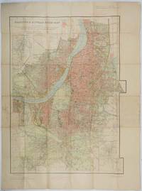
1943202248Survey of India. Third Edition. Third edition revised1943. Large folding colour map 85 x 60 cms; 101 x 75 cms sheet folding into stiff card wrappers 17 x 10.5 cms four inset maps worn with paper abrasions to the wrappers discoloured fold splits neatly repaired on reverse with washi and marginal discolouration small tidemark a little fished one spot affecting the legend at the head of the map neat ink annotations on back cover but overall in good condition. Wonderfully detailed town plan of Calcutta and Howrah showing district and municipal boundaries transportation parks & gardens water features buildings and built-up areas the three inset maps: Index to Districts Municipalities and Municipal Wards; Index to Bus Routes Calcutta and Howrah and to Dalhousie Square and Esplanade. . Survey of India. unknown
1888040755London: Spencer Blackett 1888. xi 388pp 8 bw ills. Or green gilt cloth with title and elephant in gilt. Cloth lightly rubbed at edges front hinge a little tender. A nice clean copy. Originally published in 1881 this undated second edition 1888. Lots of hunting tiger and other military comment social comment and information on the various states. . Second Edition. Hard Cover. Very Good. Illus. by The Author; Burton Miss C.G.M. 8vo. Spencer Blackett Hardcover
in-8, pp. IX, 187, leg. carta color. coeva. Con una tav. rip. Legg. slegato il piatto ant. [047]
L'INDIA DI QUA' E DI LA' DAL GANGE OVE SONO GLI STATI DEL G. MOGOL.DATA IN LUCE DA G. GIACOMO DE ROSSI IN ROMA 1683.[Veduta] (cm. 59,5 x 46) Rara carta incisa in rame con cartiglio in alto a destra. Alcuni confini leggermente colorati d'epoca. Bell'esemplare con ottimo restauro per rinforzo alla piega centrale e piccola integrazione agli angolini bianchi.[f18] Libro