196 résultats
1849GT072London: E.S. Mogg 14 Great Russell Treet Covent Garden 1849. 1st Edition . No Binding. Vg. Exhibiting a Circle of Three Miles from the General Post Office to Which is Added A COPIOUS INDEX Containing Upwards of 1500 Places with Reference to Their Several Situations.Large folding un-dissected oblong map laid on linen 54x70cms Original hand-colour to the circle parks and main routes. A very nice dark impression generally dusty but a rare map. Fine engraved map title to the upper right-hand corner. Upper lateral fold triflle cracked but sound with no loss. Index in attached case 30pp with upwards of 2000 places. v adspp. PLEASE EMAIL FOR PHOTOS <br/> <br/> E.S. Mogg, 14 Great Russell Treet, Covent Garden unknown
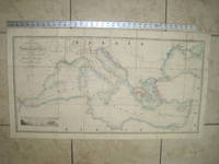
1853020822London: James Wyld Geographer to Her Majesty Charing Cross East 1853. Very Good condition only a little light soil SEE PHOTOS. This huge detailed map of the Mediterranean measures 99.5cm by 54cm when unfolded. The image itself is 93.5cm by 47.5cm. There is a finely engraved view of the entrance of Gibraltar Bay in the lower left corner. The map is a linen-backed copper engraving with original hand coloring. The map has handsome marbled paper endsheets and when folded-up measures 18cm by 12.5cm. SEE PHOTOS. Published by James Wyld Geographer to Her Majesty Charing Cross East London. A New General Atlas of Modern Geography Consisting of a Complete Collection of Maps of the Four Quarters of the Globe; Delineating their Physical Features and Coloured to Show the Limits of Their Respective States 1853. First Edition. Linen-backed hand-colored map. Very Good condition. 99.5cm by 54cm when unfolded. Great Packaging Fast Shipping. James Wyld, Geographer to Her Majesty, Charing Cross East Paperback
1823Map926London: Robt. Wilkinson 1823. 1st Edition . Hardback. Vg. Folio. 52 coloured plates - 45 maps 7 chrono-geological charts 7 maps double-page. Orignal boards and spine. Fine contents with hand-coloured maps thoughout. Rubbed and worn boards but a sound binding needing new paper covering pasted to the boards.The fine map plates are dated between 1800 and 1823 <br/> <br/> Robt. Wilkinson hardcover
187512639Wyld, London ca. 1875. Original hand-colour in block and outline, marking postal districts and railways in bold red. 21 segments, folded and linen-backed with marbled paper to folded end segments. Size 57x73, overall 59,5x77 cm. A bit tanned, verso a bit rubbed and stained.
18917594CBZürich, Hofer & Burger, 1891. Quer.-folio. (7) Bl. Mit Frontisp., Übersichtskarte und 56 Karten (chromolithogr. Reproduktionen). Illustr. Orig.-Halbleinenband. + Wichtig: Für unsere Kunden in der EU erfolgt der Versand alle 14 Tage verzollt ab Deutschland / Postbank-Konto in Deutschland vorhanden +, 7594CB
1804025579chez Charles Picquet, Paris 1804. Tadellos
1875Pa620London: William Blackwood 1875. New Edition . Hardback. Fine. Elephant Folio - over 15" - 23" tall. 20 x 135 inches. 48 double page folding colour maps and the North Polar Chart as a frontis. Fine original red half calf binding with gilt titles. Specail; index after each map. The fourth edition with each map updated to reflect the ever changing speed of the changes taking place in the industrail age. Dedication page to Queen Victoria. Each map as an adjacent index bound in and a prospectus for the companion book to the atlas is bound in at the front Atlas Geographicus' pub. separately. A complete and fine copy <br/> <br/> William Blackwood hardcover
1880NY068London: Mappin 1880. Original . No Binding. Fine. Metal dial and clasp with a small built in compass and a fine dial arm that is hinged to work out measurements. The compass dial pointer is loose but present within the bubble. A strong clasp ring 50mm surrounds the dial from the rear and the face is finely engraved with roman numerals of the hours of the day.The rear is finely stamped 1644 in minute type. The metal is not hall marked. A VERY ATTRACTIVE AND RARE ITEM c1880 <br/> <br/> Mappin unknown
1875115929The Lakeside Press, Chicago, 1875. 45,5 x 37,5 cm ; Halbleder
1830TH346London: Greenwood & Co. 1830. 1st Edition . No Binding. Vg. Dissected Map. A very large folding colour hand-washed map pub. 24th February 1830 and dissected into 40 sections and laid on a linen sheet. Massive size and covering the eastern half of the county of Lincolnshire. 79 x 204 cms. Green marbled covers and a small printed label 'EAST' to the upper cover. Sewn linen edges a trifle worn and some off-setting but a very scarce map in nice condition. The map was published as the whole county but this copy is covering the eastern section only. The map was dissecting into 72 sections when complete. SCALE 1:65000. 1 inch to 1 mile. Map 87 Carroll: The Printed Maps of Lincolnshire 1576-1900 PLEASE EMAIL FOR PHOTOS. <br/> <br/> Greenwood & Co. unknown
18472207260257xbvkGLOGAU - LEIPZIG, DRUCK U. VERLAG VON C. FLEMMING, 1844/1847. --- FORTSETZUNG der Tafeln / Maps continued: . . . Christliches Staatensystem; Buddhaistisches Staatensystem; Mohammedanisches Staatensystem; Dalmatien; Europäisches Russland; Kaukasus; Pal SCHWERER HALBLEDEREINBAND DER ZEIT mit unbedruckten Vorsatzblättern (diese geknittert und angestaubt), die Karten auf unterschiedlich starken Papieren gedruckt; QUER-FOLIO (ca. 44 x 36 x 4,5 cm; ca. 3.65 kg.).
18452407150241xbvkFirenze, Presso gli editori - Tipografia e calcografia all'insegna di Clio, 1835-1845. X, 184 p. / XIX, 116 p.; XXIII, 771 p.; II+V+1 folded plates. / VII, 1.026 p. / 1.110 p. / 618 p. / XXVII, 1.102 p.; III folded plates. / VIII, 603 p. / XII, 273; XIII, 481 p. / XVII, 619 p. / XII, 652 p.; IV (of IX?) folded plates. / IX, 385 p.; V folded plates. / XXI, 1.091 p.; IV folded plates. / 311 p. / 1.133 p. / 670, VI; 83 p. / XXV, 1.064 p.; I folded plate. / 573 p. / XXIV, 844 pages. - Overall CCXXXIII, 13.713 pages; XXV (of 30?) often multiple-folded plates**. --- GILT-DECORATED AND -TITLED 'PUBLISHERs' HALF-LEATHER BINDING WITH MARBLED PANELS, sparkled edges (Vol. 8.II: Plain brown papercover of the period); 8vo.(ca. 23 x 15 x 95 cm; ca. 17 kg.).
1821Map884Blundtisham St Ives: R.G. Baker 1821. 1st Edition . No Binding. Vg./Fine. Rolled wall map from four engraved sheets laid on a single roll of strong linen. Surveys by R.G. Allen in the Years 1816 17 18 19 & 20. Engraved by J.Allen 17 Poplar Row New Kent Road Surrey. Dedication to 'The Right Honorable Philip Earl of Hardwicke Lord Lieutenant and Custos Rotorum of the County of Cambridge. B.L. 004813374 One inch to one mile. The first large large scale survey and map of the county of Cambridge one of the last to be surveyed in England. This map was funded by public subscription. Hand -coloured and comprising 4 sheets joined and mounted on two wooden rolls to display lacking one roll. <br/> <br/> R.G. Baker unknown
1828GT100London: Richard Holmes Laurie 1828. 1st Edition . No Binding. Fine. A fine and very rare printed folding map of IRELAND by Richard Holmes Laurie 53 Fleet Street London 84 x 64 cms 33 x 25 inches with original fine hand-colouring and enclosed in the original green calf slipcase with gilt title embossed to the case edge. Divided into 18 panels on a linen sheet. No recorded copy at auction and no copy in Copac a similar dated 1817 in the BL Published 8th April 1828. No copies in WorldCat. Richard Holmes Laurie 1777-1835 was the son of Robert Laurie who whom he apprenticed as a mezzotinter who went into partnership with his fathers old partner Whittle until the latters death in 1818. Laurie and Whittle were one of the leading British Cartographic publishers in the 18th and 19th century. Richard Holmes Laurie used Captain Powell's observations of Laurie Island in the South Atlantic and printed the first map of the island which was then named after him. <br/> <br/> Richard Holmes Laurie unknown
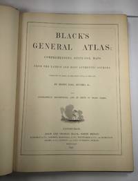
1844026815Edinburgh / London / Dublin: Adam and Charles Black / Longman / Simpkin / Whittaker / Hamilton / Cumming 1844. Good - Very Good condition. Bound in green cloth with black leather spine and corners elaborately gilt decorated. The leather is surprisingly well preserved. The cloth is faded and soiled with frayed edges. SEE PHOTOS. NO owner's name or bookplate. NOT a library discard. Imprinted "MDCCCXLIV" at the foot of the title page with "1844" hand inked beneath. All other pages are crisp clean and umarked with almost no foxing. Full title; "Black's General Atlas: Comprehending Sixty-One Maps from the Latest and Most Authentic Sources Engraved on Steel in the First Style of the Art by Sidney Hall Hughes etc. with Geographic Descriptions and an Index of 56000 Names." The maps several double page are tissue guarded and most are handcolored in red yellow and green. SEE PHOTOS. With the binder's ticket of Smith & Son 306 Lawnmarket Edinburgh. All edges gilt. Oversize hardcover. 13.25" wide by 17.75" tall. This large heavy book will require SUBSTANTIAL extra postage depending on destination that will be charged at our cost. 1844 edition. Oversize Hardcover. Good - Very Good condition. Illus. by NOT a library discard. 12pp. 61 maps 57 page Index. Great Packaging Fast Shipping. Adam and Charles Black / Longman / Simpkin / Whittaker / Hamilton / Cumming Hardcover
1875Map877London: Edward Stanford 55 Charing Cross 1875. 1st issue . paper wrappers. Fine. Folding map. 78.5 x 66.5 cms. The rare first issue of Stanford's April 19th 1875 map of the North Pole. Laid on cloth in 12 dissected sections. Coloured printing. Pasted to the lower left corner is a contemporary inset map of the Kennedy Channel entering ther 'frozen Polar Ocean' text to the reverse of the inset map.The voyages and journeys of the Artic explorers throughout the centeries are neatly printed in red throughout the map with dates including up to Austrian Exped. Payer 1874. Neatly enclosed in cloth covers when folded with a hand-written original label 'North Pole'. A lovely copy of a very scarce item. PLEASE EMAIL FOR PHOTOS. <br/> <br/> Edward Stanford, 55 Charing Cross unknown
1802Le534London: C. Cooke 1802. Extra Illustrated Fine Edition . Hardback. Vg. 4to. : containing an accurate and entertaining description of Europe Asia Africa and America being a complete and universal history and description of the whole world as divided into Empires. 2 volumes. 'Upwards of 100 engravings'. All plates and maps present as per the binders list. 24 MAPS SOME FOLDING ALL HAND-COLOURED. The two North American plates have small fold splits with a trifle loss otherwise all plates are fine and lovely dark impressions with fine hand-colouring to the maps. Undated but presumed 1802 first edition. Hand-coloured maps and copper-plate engraving throughout. Rubbed and worn full calf original binding with black calf labels gilt. Armorial bookplates in each volumes of T. Grimshaw with marbled end-papers. The fine world map was engraved by A. Arrowsmith and engraved by J. Lodge. The anon. large folding Pacific Ocean is complete but torn to the lower centre fold. The plate list calls for 8 extra plates given in the 'Fine' edition. These are all present and are beautiful strong dark impressions. PLEASE EMAIL FOR PHOTOS. <br/> <br/> C. Cooke hardcover
1850Map883Edinburgh and London: William Blackwood & Sons 1850. 1st edition 2nd issue . Hardback. Fine. Imperial Folio. 22 x 14.5 inches 57x38cms published simultaneously with divisions concerning the Geology Meteorology Phytology and Zoology of the world WITH a total of 30 maps AS CALLED-FOR. ALL DOUBLE PAGE AND HAND-COLOURED each plate measures 67x45cms. Bound in the orginal half-calf binding with cloth boards. Attractive sound spine but some wear. The 1st edition as published 1848 but with 1850 to the title-page. The large orignal edition with 30 beautiful hand-coloured engraved plates hinged. The first 1848 issue was engraved with some plates hand-coloured. This slightly later issue has all the plates engraved and with hand-colouring and the second issue of 1856 had lithographic plates with some printed colour and some hand-colour. A SCARCE ITEM. The best set of plates. <br/> <br/> William Blackwood & Sons hardcover
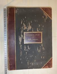
1889028277New York: Julius Bien & Co 1889. Condition of the binding is only Fair with pest damage. Leather over the spine has perished. Front and rear outer hinges cracks have been neatly reinforced with high quality clear flexible glue. Inner hinges are OK having been reinforced by the publisher/bookbinder with sturdy maroon cloth. SEE PHOTOS. Condition of all maps is NEAR FINE - FINE. NO foxing or toning. Pages are clean and unmarked. SEE PHOTOS. Includes a title page map of New Jersey Key to the System of Mapping and 19 linen-backed double page maps. Collated and complete per table of contents -- SEE PHOTOS. The maps are lithographically printed in blue red yellow and black. The double page maps open to an impressive 26.50" across by 36.50" tall. No year of publication is stated but Phillips 2149 in A LIST OF GEOGRAPHIC ATLASES Vol. 1 says 1889. The maps themselves are variously dated up to 1888. Titles of Sheets: No. 0. New Jersey State Map Geographic; No. 1. Kittatinny Valley and Mountain No. 2. Southwestern Highlands; No. 3. Central Highlands; No. 4. Northeastern Highlands; No. 5.Vicinity of Flemington; No. 6. Valley of the Passaic; No. 7. The Counties of Bergen Hudson Essex No. 8. Vicinity of Trenton; No. 9. Monmouth Shore; No. 10. Vicinity of Salem No. 11. Vicinity of Camden; No. 12. Vicinity of Mount Holly; No. 13. Vicinity of Barnegat Bay; No. 14. Vicinity of Bridgeton; No. 15. Southern Interior; No. 16. Egg Harbor and Vicinity; No. 17. Peninsula of Cape May; Unnumbered map. "New Jersey from Original Surveys based on the Triangulation of the U.S. Coast and Geodetic Survey Relief Map." Scale of first and last doublepage maps: 5 miles to an Inch. Scale of maps No. 1 to No. 17: 1 mile to an Inch. Bound in black pebble-grain cloth with gilt-stamped brown leather title label leather spine and corners leather backstrip has perished. SEE PHOTOS. The textblock could be easily rebacked or recased with no re-sewing required since all pages/maps are still securely bound together. Oversize Hardcover. 19.50" wide by 27" tall. This massive extremely heavy book will require SUBSTANTIAL extra postage at our cost based on your location. LeGear ATLASES OF THE UNITED STATES L5609. See also Schwartz and Ehrenerg's THE MAPPING OF AMERICA pp. 310-311. Phillips 2149. This massive extremely heavy book will require SUBSTANTIAL extra postage at our cost based on your location. Second Edition. Oversize Hardcover. Fair - FINE condition. Illus. by NOT a library discard. Atlas folio. Great Packaging Fast Shipping. Julius Bien & Co Hardcover
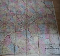
1861TS430Philadelphia: J.E. Gillette & Co. 1861. 1st Edition . printed Map. Fine. A very rare large folding map of Philadelphia divided into 36 sections each 22x23 cms and laid on a single linen sheet 132x 138cms 52x54 inches. Hand coloured. Enclosed with marbled paper covers. Only one copy traced. City of Philadelphia Parks and Recreation Historic Archives. No copy traced at auction. PLEASE EMAIL FOR PHOTOS <br/> <br/> J.E. Gillette & Co. unknown
1834Map893London: Greenwood 13 Regent Street Pall Mall 1834. 1st Edition . Hardback. Fine. Elephant Folio - over 15" - 23" tall. A fine large ATLAS with 44 of 46 lacking Suffolk and lacking Norfolk double page maps bound with central hinges. Clean paper with little off-setting foxing tanning or marks. Decorative double page engraved maps of the counties with an uncoloured vignette views. Fine elegant engraved titles Original hand-colour block and outline. 65 x 80.5 cms 25 1/2 x 31 3/4 inches printed on thick paper with wide clean and fine margins. Printed July 4th 1829 and published in the C& J Greenwoods "Atlas of The Counties of England" dated 1834. SPINE LACKING AND THE BOARDS DETACHED. PLEASE EMAIL FOR PHOTOS. <br/> <br/> Greenwood, 13 Regent Street, Pall Mall hardcover