5 782 résultats
Firenze, I.G.M., 1893. Scala di 1: 25.000. Cm. 53 x 90. In sezioni riportate su tela. Ripiegata a soffietto.
Firenze, I.G.M., 1909. Scala di 1: 25.000. Cm. 62 x 103. In sezioni riportate su tela. Ripiegata a soffietto.
Firenze, I.G.M., 1920. Scala di 1: 25.000. Cm. 100 x 75. In sezioni riportate su tela. Ripiegata a soffietto. Alcune sezioni semistaccate.
48574Paris Imprimerie Nationale 1951 in 8 (23,5x15,5) 1 volume broché, XV et 332 pages, et un feuillet volant d'errata, Service hydrographique de la marine, N°7. Bel exemplaire ( Photographies sur demande / We can send pictures of this book on simple request )
26787London - Liverpool George Philip & Son. No date (circa 1890) 1 carte entoilée et pliée d'époque fin XIXème, présentée sous chemise de percaline rouge de l'éditeur (17x11,5 cm), plat supérieur titré en lettres dorées. Carte lithographique en couleurs des Etats-Unis d'Amérique (Color lithographic map of the UNITED STATES), par J. Bartholomew F. R. G. S. chacun des états dans une couleur différente avec contours (56x65,5 cm). Bel exemplaire ( Photographies sur demande / We can send pictures of this book on simple request )
c7084Paris , Baudouin frères, 1828 ; in-8°, pleine basane fauve flammée de l' époque, dos lisse orné de palettes dorées alternant avec des fleurons dorés, titre doré sur étiquette de maroquin citron, tranches jaunes; X, (2), 739pp., ( 1)p.( texte sur 2 colonnes) ; 6 cartes dépliantes hors texte des continents et 1 mappemonde.
Milano, T.C.I., 1985, in-4, cartone editoriale, pp. 192. Con numerose illustrazioni a colori. (“Un'esplorazione” che spazia dall'alta Valsesia al Grand Canyon; dagli Xavante del Mato Grosso alla “città ideale” di San Gimignano; dalla carta topografica alla Compagnia delle Indie...).
London, Sotheby, 1965 & 1968, 2 cataloghi, in-8, br., pp. 54, 123. Con 4 tavv. in b.n. e prezzi di stima.
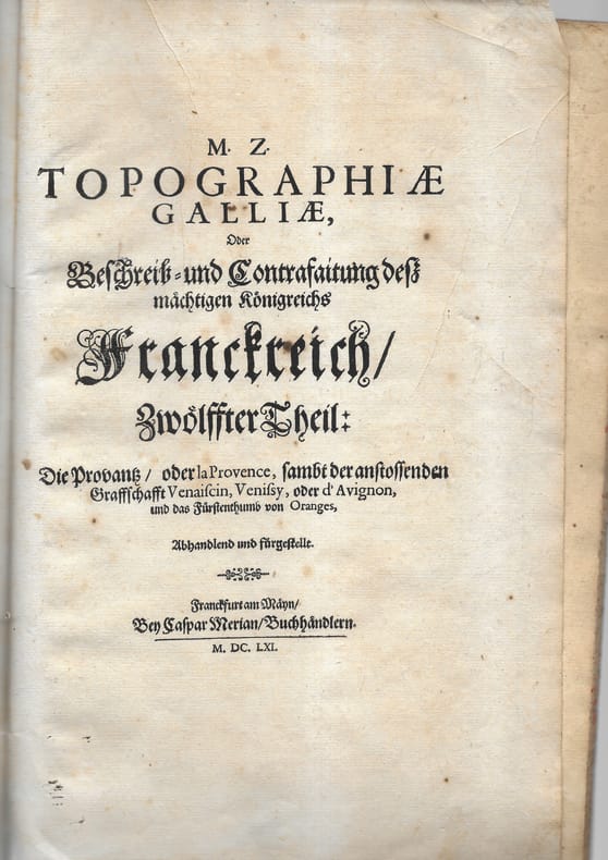
166178701 plaquette petit in-folio comprenant 9 cartes, plans et vues. Broché Bon Frankfurt Merian 1661 1 plaquette petit in-folio
Opuscoli. Le Alpi Ligure: un depliant, una carta più volte ripiegata, un libretto di presentazioni, un opuscolo, tutti in triplice lingua, francese, italiana ed inglese. Con ill. e imm. fot. a col. e in b.n. n.t.
Carta stradale più volte ripiegata con ill. a col. n.t.
Opuscolo pieghevole con mappa della Siclia e delle relative strade, distanze kilometriche dai capoluoghi e breve descrizione dei principali comuni siciliani. Pubblicato a cura della ditta "Cutrano", vendita elettrodomestici in Palermo (32h).
Venezia, Cento Servizi Interpartimentale di Cartografia e Fotogrammetria “Nani Valle” - 1993, 4to brossura, pp. 201 con numerosissime illustrazioni nel testo.
Bella carta geografica incisa in rame, formato lastra 380x500 mm. + margini, contorni acquarellati . Cartiglio in alto a destra e scala di miglia nove italiane in basso a sinistra, entrambi in bella coloritura coeva. Testo latino al verso. Tratta dall'edizione latina dell'Atlas Novus pubblicato ad Amsterdam nel 1640 ca. La carta è in cornice di legno scuro di epoca metà '900, con doppio vetro in modo da poter leggere anche il testo. Rinforzo alla piegatura centrale sul verso, ma buon esemplare.
Riproduzione sistema Gliamas. Ripiegata a soffietto, in sezioni riportate su tela. In evidenza: i laghi lombardi, il Golfo di Trieste, con Trieste, Capodistria, Pirano, Umago e parte dell'Istria. Con doppia legenda.
Cartellina di cm. 26,5 con legacci e scritta in oro al centro “Scoperte Artiche Atlante”. All’interno due grandi carte geografiche: Carta delle Terre Polari Artiche dalla Baia di Baffin all’Isola di Baring corretta sopra documenti ufficiali al 1853 dal Conte Francesco Miniscalchi Erizzo (cm. 60x90), leggermente colorata; Carta delle Terre Polari Artiche tratta da quella dell’Ammiraglio Inglese e corretta al 1853 dal Conte Francesco Miniscalchi Erizzo (cm. 60x90), leggermente colorata. Il Conte F. Miniscalchi compiuti i primi studi nel collegio di Parma e in quello di Desenzano del Garda, li completò nel liceo di Verona. La passione per i viaggi gli fu trasmessa dai genitori, con i quali percorse gran parte d’Italia già nel 1830. Qualche anno più tardi (1834), autonomamente, visitò la Svizzera, la Germania, la Danimarca, e poi (1837) la Francia e l’Inghilterra, traendo stimoli per una visione più aperta e moderna della propria classe sociale: fu infatti esponente di spicco di quella aristocrazia non parassitaria, ma direttamente impegnata nell’amministrazione e nell’ammodernamento delle proprie tenute agricole, secondo la migliore tradizione illuministica. Appassionato di studi geografici e di cartografia, il M. dette un impulso notevole alle conoscenze geografiche in Italia con un volume incentrato su Le scoperte artiche (Venezia 1855). Lo studio è ancora oggi utile sia per l’ingente materiale documentario raccolto sia «per alcune osservazioni etnologiche sui lapponi e i loro contatti con il mondo ugro-finnico, e più in generale, uralo-altaico». A parte i pregi sul piano dell’informazione e dell’erudizione, non mancano al M. anche schiette doti narrative, per l’emozione che riesce a far vibrare nel racconto delle spedizioni più sfortunate, e per la fiducia, sincera se pur non scevra d’ingenuità, dimostrata verso i progressi della scienza. Axs
Livorno, Tipografia Raffaello Giusti, 1905. Terza edizione. Volume appartenente alla Collana: Manuali Giusti. In 16mo (cm. 15,5); legatura originale in tutta tela editoriale di colore rosso con titoli in nero al piatto e al dorso; pp. XII + 64 tavole illustrate a pagina doppia con esempi di disegno cartografico di coste e spiaggie, mare, fiumi, laghi, isole, montagne, ecc. Ottima copia. Ax
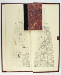
1987ST20505-11Madison Wisconsin: The Juniper Press 1987. No. 116 OF 150 COPIES. 632 x 250 mm. 25 x 9 3/4". 2p.l. 19 1 pp. <br/> Black quarter buckram over maroon marbled paper boards spine lettered in gilt. In a custom maroon buckram clamshell box. WITH 24 FACSIMILE GLOBE GORES. Signed by Woodward on the limitation page. Just a hint of use to the box booklet corners just a touch rubbed otherwise as new.<br/> <br/> This sizable attractive publication reproduces one of the largest complete sets of 16th century globe gores. Dating from around 1574 the original gores which when assembled would make a globe measuring just under 70 centimeters in diameter have been attributed to brothers Livio and Giulio Sanuto Venetian cartographers and engravers. Little is known about the gores' origin; the accompanying essay suggests they may have never made it to the final stages of publication and production possibly stopped by an outbreak of plague. This facsimile was created from the only extant set in the collection of Arthur Holzheimer 1932-2025 and was produced by his research foundation along with the Newberry Library. The gores are accompanied by a booklet by noted cartography scholar David Woodward 1942-2004 which provides background and the evidence supporting the attribution of the gores to the Sanuto brothers. The Juniper Press unknown
2 volumes grand in-8° (24x16 cm), 1018 pages, abdt ill.en n&b et couleurs, brochés sous étui carton illustré. COMME NEUF ! [FL-3]
London, Studio Editions, 1990, 4to tutta tela editoriale con sovraccopertina illustrata a colori, pp. 224 completamente illustrato a colori. In stato di nuovo.
97512Berne, Imprimerie Staempfli & Cie. 1898, 250x165mm, frontispice, VIII - 270pages, reliure percaline verte de l’éditeur. Auteur, titre dorés et ornementations à froid au dos et sur le plat supérieur. Très bel exemplaire.
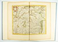
1985ST20505-12Fullerton California: Stone & Lorson 1985. ONE OF 89 COPIES in quarter vellum of a total edition of 115. 490 x 325 mm. 19 1/4 x 13". viii 23 1 pp. 1 leaf. <br/> Publisher's quarter vellum over gray paper boards covers with device in gilt smooth spine lettered in gilt. In just slightly chafed black buckram slipcase. WITH A MAP FROM THE ORIGINAL 1619 ATLAS bound in with period hand coloring. Map 293 "Tarvisina Marchia Et Tirolis Comitatus". De Hamel & Silver "Disbound and Dispersed" 186. One corner a bit bumped otherwise the main volume flawless; the map edges a bit browned and just slightly frayed a few light spots but still excellent with good color and strong general appeal.<br/> <br/> This attractive oversized production includes an original map of an important region of northeastern Italy taken from the 1619 edition of the Mercator-Hondius atlas. A pioneer in commercial cartography and a founder of the Netherlandish school of cartography and geography Mercator 1512-94 produced maps used around the world that were informed by his brilliant "Mercator Projection" which allowed the round Earth to be accurately depicted on a flat map. Near the end of his life he began work on an ambitious cosmography that would contain an account of the creation of the world a description of the universe descriptions of the countries and oceans of the world genealogies and political histories of the several countries and a chronology of the cosmos. Only the account of creation the chronology and maps of the known regions of the world came to fruition. Mercator having died before the work came to press it was completed by his heirs and published in 1595 with 107 maps. Leading Amsterdam map publisher Jodocus Hondius 1563-1612 acquired the plates in 1604 and issued the first Mercator-Hondius "Atlas" in 1606 with 37 maps he had engraved added to the original 107. Teacher and Hondius' brother-in-law Pieter van den Berg wrote the introduction and the descriptive text that appears on the versos of the maps. A 1611 edition increased the number of maps to 150 and another six were added in 1619. The hand-colored map included in our copy depicts the South Tyrol and Veneto regions including Lake Garda Verona Padua and Venice. It is accompanied with an essay by Norman J. W. Thrower 1919-2020 UCLA geography professor and cartographer describing the historical background of the atlas. Joel Silver in "Disbound and Dispersed" tells us that "the physical production of this leaf book is superb from the design by Vance Gerry to the presswork of Patrick Reagh.". Stone & Lorson unknown
Venezia, Il Poligrafo, 2004, in-4to brossura con copertina illustrata, pp. 200 con numerosissime illustrazioni in nero e a colori nel testo (Quaderni IUAV)
Progetto per un canale di collegamento tra il Mar Baltico e il Mare del Nord; il canale doveva andare da Travemünde (nel distretto di Lubecca sul Mar Baltico) a Sankt Margarethen (nel distretto di Steinburg), alla foce dell'Elba nel Mare del Nord. Tre carte in busta editoriale: due carte (ripiegate a metà) di cm 40 x 46, ed una (ripiegata in cinque parti) di cm 40 x 100 con il tracciato e il profilo del canale; tutte acquarellate. Buono stato di conservazione.