333 résultats
1817Map687Edinburgh: John Thomson 1817. 1st Edition . No Binding. Fine. Original hand-colour fine scarce unfolded copy 620 X 490 From John Thomsons New General Atlas 1817 beautifully hand-coloured on thick paper <br/> <br/> John Thomson unknown
1643Map555aLondon: Thomas Jenner 1643. printed Map. Vg. An uncoloured original map of Somersetshire with a distance grid showing the miles between the principal towns 125x130mm. A nice dark copy with a couple of worm holes <br/> <br/> Thomas Jenner unknown
1627Map863London: George Humble 1627. 1st Edition . No Binding. Fine. An original uncoloured issue of Van Der Keere's map of Somerset. Lovely dark impression of this 'miniature Speede map'. 5 x 3.5 inches <br/> <br/> George Humble unknown
1790Map924London: Thomas Bowen 1790. 1st Edition . printed Map. Fine. Folio. ND 1790. Engraved by Thomas Bowen for Barlow's General Hostory of Europe. A fine copy printed on thick paper with two folds. Nice strong impression with strong plate mark and good margins. No wear or splits. A lovely example. One small fox mark. 36x47cms. Interesting map in that Portugal is not mapped in this cartographic original merely the ' Portugal' where the country should be.ESCT 97895 Barlows History c1790. <br/> <br/> Thomas Bowen unknown
1816Map682Edinburgh: John Thomson 1816. 1st Edition . No Binding. Fine. Original hand-colour fine scarce unfolded copy small damp stain to top margin 510 X 610 From John Thomsons New General Atlas 1817 beautifully hand-coloured on thick paper <br/> <br/> John Thomson unknown
1817Map684Edinburgh: John Thomson 1817. 1st Edition . No Binding. Fine. Original hand-colour fine scarce unfolded copy 530 x 670mm From John Thomson's New General Atlas 1817 beautifully hand-coloured on thick paper wide margins <br/> <br/> John Thomson unknown
1769Map1003London: Russell and Price 1769. Original Map . No Binding. Fine. 4to. Single page map of the County of SUFFOLK John Roque.Published in ENGLAND DISLAYED Being a New Complete and Accurate Survey and Description of the Kingdom of England and Principality of Wales. Plate 16 x20cm on sheet 160 x 243mm. Fine original map printed on laid paper. Uncoloured. 2ND EDITION DATED 1769. OTHER COUNTIES ARE AVAILABLE FROM THIS ISSUE. <br/> <br/> Russell and Price unknown
1643Map588London: Thomas Jenner 1643. Original Map . printed Map. Vg. An uncoloured original map of Surry with a distance grid showing the miles between the principal towns 125x130mm. A nice dark copy with a couple of worm holes <br/> <br/> Thomas Jenner unknown
1848Map 595London: George Virtue 1848. No Binding. Fine. 10.75"x 8.25" Later hand-colour. Original steel engraving <br/> <br/> George Virtue unknown
185275869Oregon City: Surveyor General's Office 1852. First edition. 15 3/4 x 26 inches. Printed in various shades of green blue red and black. Some light toning long fold-lines else a very good map of a vastly underpopulated Territory.The map above shows the surveyed portion of the Oregon Territory as of October 21 1852. It was prepared by John B. Preston first surveyor general of Oregon."With the establishment of the Oregon Territory on August 14 1848 all grants of claims of land in the territory were nullified. It was not until the passage of the Donation Land Act on September 27 1850 that new provisions were made for acquiring unclaimed land to be based upon government surveys. John B. Preston was appointed first surveyor general of Oregon where he arrived on April 20 1851. On June 7 1851 Preston drove the “starting stake†for the base surveys of the territory at what is today known as the Willamette Stone. The east-west Willamette Base Line and the north-south Willamette Meridian still define surveying and legal land descriptions in Oregon and Washington state.Preston and his crew were able to carry out their surveying and mapping to the extent depicted on this map in just over one year. Each square of the grid termed a section is one mile on each side and includes 640 acres of land—the maximum acreage allowed for a married couple making a claim under the Donation Land Act; a single man could claim up to 320 acres. Thirty-six sections make up a township.The surveyors took careful note of waterways hills prairies and roads. Some recognizable places are already viable communities such as Salem and Lafayette; other communities of the period—Champoeg Fairfield Cincinnati for example—have vanished as meaningful places. All three of those were river landings that were affected by floods channel changes and the eventual disappearance of river transportation. Notably absent from the map is Mission Bottom or Mission Landing the by-then-abandoned site of the Methodist mission of the 1830s and St. Paul on French Prairie. The roads that are mapped include ancient routes such as the California-Oregon Trail which had sections that paralleled both sides of the valley as well as newer roads established in recent years. The roads converging on Salem from the outlying farming districts for instance reflect its recent importance as a mill town powered by the waters of Mill Creek Surveyor General's Office unknown
1821Map884Blundtisham St Ives: R.G. Baker 1821. 1st Edition . No Binding. Vg./Fine. Rolled wall map from four engraved sheets laid on a single roll of strong linen. Surveys by R.G. Allen in the Years 1816 17 18 19 & 20. Engraved by J.Allen 17 Poplar Row New Kent Road Surrey. Dedication to 'The Right Honorable Philip Earl of Hardwicke Lord Lieutenant and Custos Rotorum of the County of Cambridge. B.L. 004813374 One inch to one mile. The first large large scale survey and map of the county of Cambridge one of the last to be surveyed in England. This map was funded by public subscription. Hand -coloured and comprising 4 sheets joined and mounted on two wooden rolls to display lacking one roll. <br/> <br/> R.G. Baker unknown
1830TH346London: Greenwood & Co. 1830. 1st Edition . No Binding. Vg. Dissected Map. A very large folding colour hand-washed map pub. 24th February 1830 and dissected into 40 sections and laid on a linen sheet. Massive size and covering the eastern half of the county of Lincolnshire. 79 x 204 cms. Green marbled covers and a small printed label 'EAST' to the upper cover. Sewn linen edges a trifle worn and some off-setting but a very scarce map in nice condition. The map was published as the whole county but this copy is covering the eastern section only. The map was dissecting into 72 sections when complete. SCALE 1:65000. 1 inch to 1 mile. Map 87 Carroll: The Printed Maps of Lincolnshire 1576-1900 PLEASE EMAIL FOR PHOTOS. <br/> <br/> Greenwood & Co. unknown
1829Map887London: Greenwood 13 Regent Street Pall Mall 1829. 1st Edition . No Binding. Fine. Folding map. A fine large folding double page map with the original centre hinge present. Clean paper with no off-setting foxing tanning or marks. Decorative double page engraved map of the county with an uncoloured vignette view of Lambeth Castle & Church engraved by R. Creighton. Fine elegant title to the top left. Original hand-colour block and outline. 65 x 80.5 cms 25 1/2 x 31 3/4 inches printed on thick paper with wide clean and fine margins. Printed July 4th 1829 and published in the C& J Greenwoods "Atlas of The Counties of England" dated 1834. PLEASE EMAIL FOR PHOTOS. WE have many more Greenwoods from this atlas in stock all individually priced. Please email for details. <br/> <br/> Greenwood , 13 Regent Street, Pall Mall unknown
1829Map909London: Greenwood 13 Regent Street Pall Mall 1829. 1st Edition . No Binding. Incomplete original Map. A large folding double page map UNFOLDED EXAMPLE with cropped and damaged margin including the dec. border. Decorative double page engraved map of the county with an uncoloured vignette view of engraved by R. Creighton. Fine elegant title to the top left. Original hand-colour block and outline. 65 x 80.5 cms 25 1/2 x 31 3/4 inches printed on thick paper with wide clean and fine margins. "Atlas of The Counties of England" dated 1834. PLEASE EMAIL FOR PHOTOS. WE have many more Greenwoods from this atlas in stock all individually priced. Please email for details. <br/> <br/> Greenwood , 13 Regent Street, Pall Mall unknown
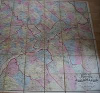
1861TS430Philadelphia: J.E. Gillette & Co. 1861. 1st Edition . printed Map. Fine. A very rare large folding map of Philadelphia divided into 36 sections each 22x23 cms and laid on a single linen sheet 132x 138cms 52x54 inches. Hand coloured. Enclosed with marbled paper covers. Only one copy traced. City of Philadelphia Parks and Recreation Historic Archives. No copy traced at auction. PLEASE EMAIL FOR PHOTOS <br/> <br/> J.E. Gillette & Co. unknown
1814Map689Edinburgh: John Thomson 1814. No Binding. Fine. Original hand-colour fine scarce unfolded copy 520 X 650 From John Thomsons New General Atlas 1817 beautifully hand-coloured on thick paper <br/> <br/> John Thomson unknown
1880S218London: Hakluyt Society 1880. 1st Edition . No Binding. Vg. Folio. A single sheet folding map based on the map in Richard Hakluyt's ' Principall Navigations Voyages and Discoveries of the English Nation' associated with Edward Wright map-maker. The Wright Molyneux map. Called by Shakespeare in Twelth Night ' the new map with augmentation of the Indies'. To illustrate the Voyages of John Davies'. Map only lacks the 16pp booklet. 29 x 21 inches. One small repair. A trifle foxed. PLEASE EMAIL FOR PHOTO. Produced by THE TYPOGRAPHICAL PRINTING COMPANY. <br/> <br/> Hakluyt Society unknown
1817Map706Edin`: John Thomson 1817. 1st Edition . No Binding. Fine. Original hand-colour fine scarce unfolded copy one edge sl. Stain 410 x 520 From John Thomsons New General Atlas 1817 beautifully hand-coloured on thick paper <br/> <br/> John Thomson unknown
Map617George Humble. 1st Edition . No Binding. Fine. An original uncoloured issue of Van Der Keere's map of Warwickshire. Lovely dark impression of this 'miniature Speede map'. 5 x 3.5 inches <br/> <br/> George Humble unknown
Map6331695. No Binding. Very Good. UNCOLOURED V.G. 14.25 X16.75 <br/> <br/> 1695. unknown
1627Map635London: George Humble 1627. 1st Edition . No Binding. Fine. An original uncoloured issue of Van Der Keere's map of Westmoreland and Cumberland Lovely dark impression of this 'miniature Speede map'. 5 x 3.5 inches. Nice wide margins <br/> <br/> George Humble unknown
1823Map921London: C. Smith 1823. Corrected 3rd Edition . No Binding. Fine. Folding map. Original hand-coloured map dated 1823 58x50 cms. Double-page folding plate printed on fine paper and original hand-colour. With a numbered list of the Wapontakes including 8 examples found on this plate. A lovely example of the 3rd 1823 issue of the Jan 6th 1804 map by C. Smith of 172 The Strand London. Smith's County Altas being a complete set of County Maps divided into Hundreds. Wide margins no wear and very clean example with no marks or wear to the centre-fold. <br/> <br/> C. Smith unknown
1830Map914London: Longman Rees Orme Brown and Green Paternoster Row 1830. 1st Edition . printed Map. Fine. Folio. ND c1850 Plate XXX double page folding original map with outline hand coloured boundaries and relief shown by hachures. Finely engraved decorative wide border and wide margins to three sides. Strengthened hinge to the rear centre fold. PLEASE EMAIL FOR PHOTOS 42x53 cms <br/> <br/> Longman, Rees, Orme, Brown and Green, Paternoster Row unknown
1705Map901London: Richard Blome 1705. re-issue . No Binding. Vg. Folio. 50x42cms. Nice dark impression printed on thick paper. Single original plain red ink hand drawn crossing borders to the image edges and repeated in the blank verso. Uncoloured map. Originally engraved by Joseph Moxon in 1671 this later issue of 1705 by Richard Blome has the cartouche and coats of arms and lower engraving re-engraved and the lower part of the plate removed and replaced with a irnage of small hills! The Jonas and his whale engraving has also been re-engraved at the centre top of the image. Now measuring 27x45cms. Very wide margins. Joseph Moxn 1627-1699. The map was first designed by Nicolas Visscher. <br/> <br/> Richard Blome unknown
1705Map902London: Richard Blome 1705. re-issue . No Binding. Vg. Folio. 50x42cms. Nice dark impression printed on thick paper. Single original plain red ink hand drawn crossing borders to the image edges and repeated in the blank verso. Uncoloured map. Originally engraved by Joseph Moxon in 1660 this later issue of 1705 by Richard Blome has the cartouche and corner engraving removed and rplaced by a compass and pair of dividers. Very wide margins. Joseph Moxn 1627-1699. The map was first designed by Nicolas Visscher. <br/> <br/> Richard Blome unknown