12 890 résultats
Paris, Masson & Cie, 1904; in-folio, atlas de 55 cartes, cartonnage d'éditeur, sans jaquette. Très bon état.
Very Good Turkish Modern cloth bdg. Roy. 8vo. (24 x 17 cm). In Turkish. 50, [2] p., 9 unnumbered folded maps. Türk süel alaninda harita ve krokilere verilen deger ve Ali Macar Reis atlasi. First Edition. Extremely rare.
187354200Chicago IL: Warner & Beers 62 & 64 Lake Street 1873. Atlas folio. 16 x 18.7 in. 3 3 5-91 1 pp. Woodcut-engraved title page 42 hand-coloured steel-engraved maps all w/ nicely executed engraved borders couple double-page additional steel-engraved “Family Records†page filled-out in manuscript inserted. Original front panel stamped in decorative gilt lettering mounted on recent black cloth binding occasional edgewear minor soiling to fore-edges of textblock couple very minor closed tears still VG copy from the library of John Inkster 1828-1908 Scottish-American farmer who immigrated in 1860 to Pilot Township Kankakee IL to farm with his brother James and then continued West to farm in Coast Fork Lane Co. Oregon and finally the Washington Territory in 1881 where he homesteaded near Davenport WT assisted in building Fort Spokane and served as County Commissioner from 1886-1892. First edition of this exceedingly scarce Illinois Atlas published just after the great Chicago Fire of 1871 featuring an unrecorded platt map of Pilot Township in Kankakee County Illinois showing all the properties and property owners in 1872. This atlas also features the Railway map of Illinois City Map of Chicago maps of all the Illinois Counties and large map of the United States. Of special interest are the excellent early western maps of Texas; Minnesota Nebraska and the Dakota Territory; Wyoming Montana and Idaho Territories; Nevada and California along with map of Oregon and Washington and Alaska Territories. The Beers and Warners were successful map publishers in Chicago IL from about 1850 to 1886 and often publishing as Warner & Beers the cartographers produced a series of early state and county atlases and regional maps which were considered the most detailed maps produced at the time of the respective regions. As their Township and County maps often detailed individual homes and landowners they provide invaluable reference tools to researchers historians and genealogists. No copies located of this specific Warner & Beers Atlas in Worldcat; No individual copies located of the Pilot Township Map; See: Portrait & Biographical Record of Kankakee County Illinois 1893 pp. 390-391; An Illustrated History of the Big Bend Country embracing Lincoln Douglas Adams & Franklin Counties 1904 pp. 421-425. Warner & Beers, 62 & 64 Lake Street, hardcover
184040828(Mainz, um 1840). 39,5 x 48 cm. Mittig gefaltet (wie erschienen).
184040827(Mainz, um 1840). 39,5 x 48 cm. Mittig gefaltet (wie erschienen).
5251Paris, Imprimerie de l'Illustration Economique et Financière, 1926 . 1 volume in-4, 109 pp., très nombreuses illustrations in texte, 1 grande carte de l'Indochine, 7 pages de publicités pour des sociétés Indochinoises in fine, reliure moderne plein cuir brun, couvertures illustrées conservées. Très bon état (malgré une petite découpure de texte page 5 et 6).
11400Hanoï, Service Géographique de l'Indochine, 1920. 1 volume in plano (31*41 cm) contenant 46 cartes en couleurs sur doubles pages montées sur onglets. Reliure demi-toile, dos usagé, plats cartonnés marbrés, intérieur en bon état. Atlas à l'échelle 1/1.000.000e.
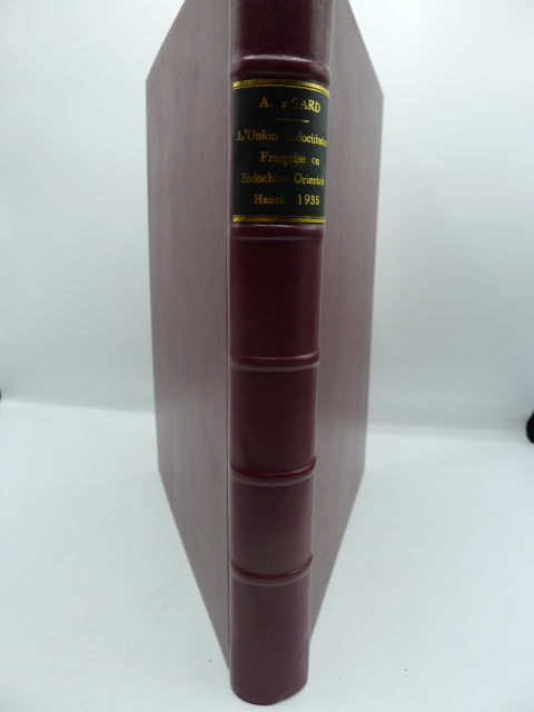
7569Hanoï, Imprimerie d'Extrême-Orient, 1935. 1 volume in-4, 370 pp., reliure moderne plein cuir. Richement illustré de XIV cartes en couleurs hors texte, de 48 cartes, plans et figures in texte et de 30 planches hors texte représentant plusieurs centaines de clichés photographiques. Avec un bel envoi de l'auteur à Monsieur Charton, Inspecteur Conseil de l'Instruction Publique, Lycée Albert Sarraut, Hanoi, 12 novembre 1938.
12299Paris, Augustin Challamel, Editeur, 1903. 1 volume in-4, 54 pp., reliure ancienne demi-basane, plats cartonnés, enrichi de 9 planches de cartes en couleurs, très bon état.
9205Paris, Imprimerie de l'Illustration Economique et Financière, 1926 . 1 volume in-4, 109 pp., très nombreuses illustrations in texte, 1 grande carte de l'Indochine, 7 pages de publicités pour des sociétés Indochinoises in fine, reliure moderne plein cuir brun, couvertures illustrées conservées. Très bon état (malgré une petite découpure de texte page 5 et 6).
Very Good Turkish, Ottoman (1500-1928) Original color map. Folded. Oblong atlas folio. (50 x 60 cm). In Ottoman script. [MAP of EAST ANATOLIA] Malatya - Divrigi, Mancinik, Adiyaman, Harput. Shows Malatya, Adiyaman and Kharpout region; Firat River (Euphrates), Yazi Düzü, Erguvan etc. Scale: 1/200.000. This is one the serie of the Bonn projection maps which are the first map series in modern techniques in Turkey and the Ottoman Empire. In order to produce these maps covering Turkish territory, Reconnaissance Branch was incorporated into The Mapping Commission. The maps were produced in the datum based on the latitude and longitude of Ayasofya Mosque in equal area Bonn Projection. The field works for the 123 sheets covering the country were conducted by 76 staff. The production was completed in 18 years starting from east west. Field works continued without stopping except in years 1914 and 1920. This map series called also reconnaissance maps contributed a lot to producing 1:25.000 scale maps. Hegira: 1332 = Gregorian: 1916. Not description on map-maker. According to Türkezer & Çobanoglu: History of Mapping in Turkey-1:200.000 Scale Maps, cartographer of this map is Kambay, Cemal.
46405253[Paris, Boisseau, vers 1640], 11,5 X 17,5 cm. sur une feuille de 14 x 20 cm., monté dans un passe-partout. Vue de la ville de Crémieux tirée de Topographie françoise parue chez Boisseau.
184040833(Mainz, um 1840). 39,5 x 48 cm. Mittig gefaltet (wie erschienen).
184040836(Mainz, um 1840). 39,5 x 48 cm. Mittig gefaltet (wie erschienen).
Faksimilierte Auswahl aus dem 92 Karten umfassenden Deutschland-Band von Janssons monumentalem Atlas, dessen deutsche Ausgabe in 10 Bänden im Jahr 1658 in Amsterdam erschienen war. Beigelegt ist ein grossformatiges Textheft mit einer Einführung zum „historischen und kulturellen Hintergrund” von Traudl Seifert (damalige Leiterin der Kartensammlung der Bayr. Staatsbibliiothek, deren Exemplar als Vorlage für den Nachdruck verwendet wurde) und den faksimilierten Texten aus Janssons Atlas zu den entsprechenden Karten. - Klappen mit leichten Knickspuren, sonst sehr sauberes, dekoratives Exemplar.
189056329Yamada Village Japan: n.p. ca. 1890. 4to. 7.5 x 11 in. 354 pp index maps & sections separately paginated. entirely in original manuscript with over 250 plat and section maps many double-page some folding many w/ additions tipped-in or laid-in as supplemental overlays and many w/ additional manuscript annotations most hand-coloured throughout. Original beige limp boards punch-sewn at gutter margin title in manuscript on front cover some scuffing wear occasional internal worming mildly affecting some maps still a VG- exemplar. An extraordinary Meiji-era manuscript real estate plat map atlas for the Yamada Village and environs of the Keta District in present-day northern Hyogo Prefecture. Traditionally ruled over by descendants of the Miwabe-no-Atai clan this real estate atlas volume encompasses hundreds of plat maps tied to outline maps with the plats all numbered and many colour-coded with colour coding to the opening index. The creator of this map atlas appears to have been commissioned by local land agents following the economic expansion after the opening of the Hyogo Harbor in 1867 for foreign trade while quickly became one of the largest trading ports in Japan. The Tajima province is perhaps best known as the birthplace of Kobe Beef or Tajima Wagyu traditionally compact working cattle with a calm nature but which quickly came into high demand as Kobe Beef in the late 1880s as the large foreign trading and tourist community desired beef and the Tajima cattle were especially desired. This also contributed to a rising demand for land in which to raise the Tajima Wagyu cattle and land prices. At the same time the nearby coast also began slowly developing a small tourist trade and coastal resorts. The map sections include No. 5 -- Kitakami no machi; No. 11 -- Sampo no matsu; No. 12 - Shita takimiya; No. 13 - Okawahara; No. 14 - Takimiya; No. 30 - Kita shitaya as well as No. 36 - Kawahara. In April 1896 the Keta District was dissolved and merged into the Kinosaki District along with the Mikumi District and became the Hyogo Prefecture anchored by the city of Kobe. The additional supplemental pieces tipped-in others laid-in and the many add-ons to the folding map with many bearing annotations indicate that this was a meticulously maintained working document for Meiji land agents. We have been unable to locate any similar manuscript or printed real estate atlases for this era and geographical location. See: Mochizuki Kotaro Japan To-Day: A Souvenir of the Anglo-Japanese Exhibition Held in London 1910 Special Number of the “Japan Financial and Economic Monthly;†Mike Buchanan Hyogo Prefecture Tajima Wagyu History Australian Wagyu Forum 2018; Masanobu Suzuki Development and Dispersal Process of Ancient Japanese Clans 2003. [n.p.], hardcover
1837891931837. JAPANESE ATLAS Ichikawa Tokei. KOKUGUN ZENZU 2 volumes. Nagoya Edo Osaka Kyoto. Eirakuya Toshiro et al. Preface dated 1837. String-bound Japanese-style fukuro-toji printed paper title labels. Original yellow covers. Covers are a bit soiled with ownership labels. Internal occasional marginal worming. Printed in color woodblock throughout an interesting atlas of the traditional governing divisions of Edo-era Japan. unknown
Very Good German Original color map on cloth. A little foxing on cloth. Very good. Folded. Oblong folio. (45 x 51 cm). In German. Shows N. Enyed, Zalathna, Mediasch, Hermannstadt, Hatszeg, Petroseni, Ôzt River, etc. Scale: 1/300,000. Sibiu (Sibiiu - Hermannstadt - Nagyszeben) is a city in Romanian Transylvania. The city straddles the Cibin River, a tributary of the river Olt. The first official record referring to the Sibiu area comes from 1191 when Pope Celestine III confirmed the existence of the free prepositure of the German settlers in Transylvania, the prepositure having its headquarters in Sibiu, named Cibinium at that time. In the 14th century, it was already an important trade center. As of the year 1376, the craftsmen were divided into 19 guilds. Sibiu became the most important ethnic German city among the seven cities that gave Transylvania its German name Siebenbürgen (literally "Seven Citadels"). It was home to the Universitas Saxorum (Community of the Saxons), a network of pedagogues, ministers, intellectuals, city officials, and councilmen of the German community forging an ordered legal corpus and political system in Transylvania since the 1400s. During the 18th and 19th centuries, the city became the second -and then the first most important center of Transylvanian Romanian ethnics. The first Romanian-owned bank had its headquarters here (The Albina Bank), as did the ASTRA (Transylvanian Association for Romanian Literature and Romanian's People Culture). After the Romanian Orthodox Church was granted status in the Habsburg Empire from the 1860s onwards, Sibiu became the Metropolitan seat, and the city is still regarded as the third-most important center of the Romanian Orthodox Church. Between the Hungarian Revolution of 1848 and 1867 (the year of the Ausgleich), Sibiu was the meeting-place of the Transylvanian Diet, which had taken its most representative form after the Empire agreed to extend voting rights in the region (Source: Wikipedia). A sheet of the collection of 'The general map of Central Europe'. appeared in the years between 1873-1876 with the work of Joseph Ritter von Scheda, (1815-1888) who was a general, geographer, and cartographer.
190763122Chicago & New York: George F. Cram 55-61 Market Street 1907. Folio. 12.25 x 15 in. 160 pp. Illustrated title in blue. Over 100 photo illustrations maps colour maps many double-page with Cram’s Kansas 51.5 x 31.5 inch map in full colour laid-in minor soiling faint markings from glue offsetting where previously attached to rear pastedown. Dark forest-green coloured publisher’s cloth silver lettering & decoration embossed on front cover minor soiling minor wear to corners slight bumping head & foot of spine light restoration back cover still a VG- copy. First edition of this rare Cram’s reference atlas replete with colour World maps and maps of the individual states and many different local cities including Omaha Minneapolis St. Paul St. Louis Chicago and others. The section on Kansas includes two colour maps depicting manufacturing and mechanical industries by counties as well as statistical map showing live stock and dairy products. The photos depict the Kansas oil fields brick yards in Pittsburg KS; oil tank farms in Neodesha Strawboard Factory in Coffeyville streets in Atchison and other areas across the state. The atlas is also unusually complete with the very scarce giant oversize colour Kansas map typically missing from these Cram’s local history reference atlases. George F. Cram, 55-61 Market Street, hardcover
Sehr seltener Atlasband zum militärischen Kartenwerk über den napoleonischen Feldzug entlang des Rheins und durch Süddeutschland im Jahr 1796. – Inhalt: Als letzter Generalfeldmarschall des »Heiligen Römischen Reiches Deutscher Nation«, demissionierte Karl nach der vernichtenden Niederlage bei Wagram (1809) und stellte u.a. dieses opulente Kartenwerk zusammen, dem zwischen 1814 und 1819 eine dreibändige Textausgabe folgen sollte. 1862 schließlich gab die österreichischen Staatsdruckerei eine Faksimile-Ausgabe des Werks heraus. – Die 12 von verschiedenen Offizieren gezeichneten und den ersten Stechern ihrer Zeit wie Kilian Pohnheimer gestochenen großformatigen Kupfer zeichnen die 1796 im Rahmen des »Ersten Koalitionskrieges« erfolgten Kampfhandlungen zwischen dem Heer Napoleons und einer europäischen Koalitionsarmee unter der Führung des österreichischen Erzherzogs Karl nach. Die Mappe enthält eine Übersichtskarte mit der Begrenzung durch den Rheinlauf von Basel bis Köln im Westen bzw. Linz und Prag im Osten, ferner eine Karte des Lahn-Sieg-Gebietes, detaillierte Umgebungskarten von Malsch, Rastatt, Neresheim, Amberg, Würzburg, Biberach, Emmendingen, Schliengen, Kehl, Hühningen (in dieser Reihenfolge). – Erhaltung: Mappenrücken fachkundig mit starkem Papier ergänzt, Decken stellenweise etwas fleckig, Ecken und Kanten bestoßen, die auf dickem Papier gedruckten Karten teils gebräunt, gering stock- bzw. schmutzfleckig, Faltstellen außen mit leichten Rissen, insgesamt sauberer Satz. – Seltenheit: Gemäß JAP/APO kamen in den letzten 4 Jahrzehnten lediglich 2 vollständige Exemplare des hier angebotenen Atlasbandes zur Auktion. – Literatur: Holzmann-Bohatta II, 8159; ÖBL zit. DBA 2 681, 445 u. Wurzbach VI, 379.
199554502Weißenhorn, Anton H. Konrad Verlag, 1995. Qu.-4°. Mit zahlr. tlw. ganzs. bzw. farb. Abbildungen. 382 S., 1 Bl., Illustr.-OPpbd.
69584P., Librairie Illustrée, sans date, 2 forts volumes in 4° reliés demi-veau bleu nuit, dos à nerfs ornés, XLVIII-721 et 817 pages ; quelques rousseurs ; petits frottis.
2006LFA-126719902Une publication de 176 pages, format 235 x 300 mm, illustrée + cartes, brochée couverture couleurs, publiée en 2006, bon état
Paris, Lebail-Weissert, 2003-2007. Ensemble de 6 catalogues de format in 4°; environ 1000 pp.; nombreuses illustrations en couleurs. Bel état. Luxueux catalogues; exactement 1700 numéros soigneusement décrits.
201710331Paris, Universalis, 1990 ; in-folio, 435 pp., cartonnage de l'éditeur. Avec jaquette.