[MT FUJI CLIMBING ROUTE MAP FAN].Biblio.com
4 345 résultats
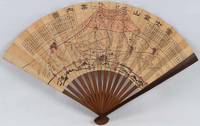
1718220781Japan.: 大海扇子商會. Taikai Sensu Shōkai. Meiji 17 1884. Black and white printed map with handcoloured pink highlights 23.5 x 39cm date stamped on reverse. A little minor wear at folds but overall very good. This fascinating fan was produced as a commemorative item marking a climb to the summit of Mount Fuji. A stamp on the reverse is dated 27 July Year 17 and appears to have been applied at the summit. This date likely refers to Meiji 17 or 1884. Commemorative fans of this type were popular at the time and the paper printing and general style appear consistent with that period. The red printed patterns and characters on the reverse also back up our belief that the fan was obtained at the summit. The pictorial map of the mountain shows four different routes to the summit marked in red with distance charts printed above. <br> <br>Mount Fuji is Japan’s highest peak. Long perceived as a sacred mountain it has a Shinto shrine at the summit and the climb has traditionally been regarded as a form of pilgrimage. . 大海扇子商會. [Taikai Sensu Shōkai]. unknown
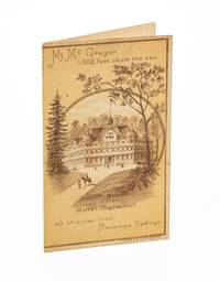
3735323<p>New York: Judge Publishing Co. Lith ca. 1885. 4 pp. Bifolium brochure. 6 x 3½ inches. Lithographic covers. Pages 3-4 with one diagonal crease line; good.</p> <p>A rare promotional piece advertising The Hotel Balmoral and Mt. McGregor Railroad Company aimed at tourists visiting Saratoga Springs New York for a mountain-top excursion. A timetable inside notes that the train journey from Saratoga Springs to the summit of Mt. McGregor took about 35 minutes. Visitors could enjoy expansive views from the summit and tour General Grant’s Drexel Cottage. In a nineteenth-century hand “July 23 1885†is neatly inked at the bottom of the back cover.</p> unknown
AQ24783s.l.: s.n. s.d. Manuscript of paper. 14pp. Bound with: ACTS - GEORGE III. Drop-head title: An act for Amending an Act made in the Twenty-ninth Year of the Reign of His Present Majesty for making and repairing the Road from the City of Glasgow in the County off Lanerk to Muirkirk in the County of Ayr. s.l. s.n. 1791. 11pp 1. Docket title to verso of final leaf of text. Not in ESTC. And: ACTS - GEORGE III. Drop-head title: An act.for Making and repairing the Road from the City of Glasgow by Muirkirk to the Confines of the County of Ayr. s.l. s.n. 1798. 16pp. Docket title to verso of final leaf of text. Not in ESTC. And: ACTS - GEORGE III. Drop-head title: An act for Continuing altering and enlarging the Terms abnd Powers of several Acts for making and maintaining certain Roads in the Counties of Lanrak Ayr and Renfrew and building a Bridge over the River Clyde at Dalmarnock. London. J. Richardson 1819. 40pp 2. Docket title to verso of final leaf of text. And: Nine leaves of manuscript abstracts of minutes of meetings held by the committee charged with road maintenance of the Muirkirk and Cambuslang roads and related amendments to legislation between 1819 and 1834. Folio. Nineteenth-century half-calf marbled boards contrasting red morocco lettering-piece. Extremities worn upper board detached. Inked ownership inscription of J. Ewing to recto of FFEP manuscript headings to drop-head titles of all printed material occasional dust-soiling scattered foxing. A sammelband of manuscript and apparently unrecorded printed material relating to the construction and maintenance of the Muirkirk and Cambuslang roads from the late-eighteenth to mid-nineteenth-century. . [s.n.], [s.d.] hardcover
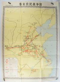
1981173280Beijing.: 地图出版社. Di tu chu ban she. 1st Edition 2nd Printing. 1981. Large Chinese coloured educational map folded scale 1:2000000. Legend lower left corner shows the routes of military advance led by peasant rebellion leaders' 陈胜Chen Sheng and 吴广Wu Guang in red and other military activities led by 项羽Xiang Yu and 刘邦Liu Bang in various colours. In original worn paper wrapper map in very good condition. Text in Chinese. Map measures 105.5 x 76.6cm. . 地图出版社. [Di tu chu ban she]. unknown
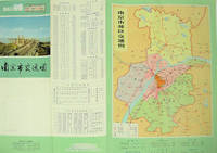
1977137003No place of publication.: 江苏人民出版社.Jiangsu ren min chu ban she. 1st Edition 2nd Printing. 1977. Colour Chinese transportation map featuring the city of Nanjing capital city of Jiangsu Province and its surrounding regions. Upper side: A transpiration map of Nanjing and neighbouring counties right section with a list of names of stations buses trains coaches ferries and their addresses lower right edge tourist guide including the addresses and phone numbers of major travel agents hospitals cinemas and more left section accompanied by two tables of bus routes. On reverse: a "Map of Nanjing Municipal Transpiration Map" scale not given a chart of terminus for bus and trolley bus lower right section. Some soiling on reverse stamp of a prior dealer in Guangzhou a handwritten date of "September 17th 1977" upper side light creases good copy. Text in Chinese. Sheet measures 37.8 x 52.3cm. . 江苏人民出版社.[Jiangsu ren min chu ban she]. unknown
179725649chambery 1797 1 document original sur papier velin crème ligné : FEUILLE DE ROUTE POUR JULIEN LAURENT [NATIF DE NANTES], BRIGADIER AU 7EME RÉGIMENT DE HUSSARDS COMPAGNIE N°7 PARTANT DE CHAMBÉRY POUR SE RENDRE A NANTES DÉLIVRÉE PAR CLAPIER : COMMISSAIRE DES GUERRES DE CHAMBERY DU 26 FRUCTIDOR AN V, format : 38,5 x 28 cm, préimprimé en noir et manuscrit à l'encre brune de deux pages, avec notés la liste des arrets dans les villes traversées avec signatures , cachet noir de la présidence de l'autorité municipale de Nantes gravé en noir, + 1 document original sur papier velin bleu ligné : CERTIFICAT DE VISITE ET CONGÉ ABSOLU POUR CAUSE DE BLESSURES [CERTIFICAT DE RÉFORME] DÉLIVRÉ PAR L'ARMÉE DES ALPES - HÔPITAL MILITAIRE D'AIX DU 17 FRUCTIDOR AN V (3 SEPTEMBRE 1797) SIGNÉ CLAPIER, format : 25 x 38 cm, certificat détaillé et signé côté Nantais par l'Autorité Municipale de Nantes (avec cachet illustré en noir et signature de CHEVY Ainé, Administrateur Municipal de la Commune de Nantes),
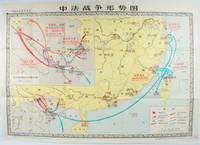
1978171343北京. Beijing.: 地图出版社.Di tu chu ban she. 1978. Large Chinese map in colour showing southern part of China and northern Vietnam folded in original envelope scale 1: 150000 inset map upper left corner scale 1:800000. Both maps show the battles between Qing court and French army between 23 Aug 1884 and 25 Mar 1885. Original paper envelope repaired with acidic free tape map in very good condition. Text in Chinese. Sheet measures 76.8 x 107.1cm. . 地图出版社.[Di tu chu ban she]. unknown
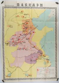
1980176714北京. Beijing.: 地图出版社.Di tu chu ban she. 1st Edition 1st Printing. 1980. Large Chinese education map folded with original envelope scale 1:1500000 legend left lower corner showing the military advance routes and battle grounds led by several leaders of the agrarian rebels including 王薄 Wang Bo 窦建德 Dou Jiande 杜伏威 Du Fuwei and 翟让 Zhai Rang. Very good copy. <br> <br>Text in Chinese. Sheet measures 106.8 x 76.52cm. . 地图出版社.[Di tu chu ban she]. unknown
in-8, 76 pp., nombreuses photographies en noir, broche, couverture muette sous jaquette. VG - Bel exemplaire. [BU-1]
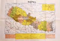
1979207710Dehli.: Indian Book Depot Map House. 1979. Colour map on blush coloured paper 44.2 x 63.6 cms; 53.6 x 75.9 cms sheet inset map of air service routes folding into pictorial card wrappers 25.5 x 19.3 cms issued into colour pictorial paper folder in very good condition. Map shows Nepal and surrounding borders with India Tibet and China provinces picked out in colour international and state boundaries sealed roads railway lines canals lakes springs rivers towns and villages tourist places temples and the inset map shows air services from Nepal to Thailand and India. The rear wrapper shows a view of Pashupatinath Temple the oldest Hindu temple in Kathmandu. . Indian Book Depot (Map House). unknown
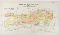
1912177249Sydney.: W.A. Gullick Govt. Printer. 1912. Large lithographed folding county map 78.8 x 45.4 cm the parishes highlighted in colour two small fold splits slight toning in very good bright condition. Attractive map from the Report on the first Interstate Conference on Artesian Water Sydney 1912 showing boundaries of water trust districts proposed boundaries with position and length of drains for the counties of Denham and Jamison in northern New South Wales boundaried by the Namoi River to the South. . [W.A. Gullick, Govt. Printer] unknown
192548702N.P.: Privately printed n.d. ca 1925. ca 1925. 9" x 6" color pictorial wrappers. 47 pages tinted illustrations maps tour plans. Numerous tour itineraries and schedules with numerous beautifully colored photographs of various areas buildings and parks. Tours discussed include Glacier and Yellowstone; Colorado and Yellowstone; Inter-Mountain Route From Colorado to Yellowstone and Glacier; Colorado and Glacier. General information for the tourist including cost of tours discussion of climate apparel booklets of possible interest a list of ticket routing for various tours calendar schedules for various tours etc. Separate map depicting each tour. Very good plus. Privately printed, n.d. [ca 1925]. unknown
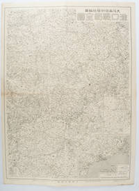
1572172829大阪. Osaka.: 大阪毎日新聞社. Osaka Mainichi Shinbunsha. 昭和 13 1938. Black and white map folded showing Hankow one of the three cities which merged to become Wuhan 54.5 x 49cm scale 1:2000000. Some light browning tiny closed tear upper margin neatly repaired with conservation standard tape. Good copy. This Hankow/Hankou War Situation Map is a supplement map of Osaka Mainichi Newspaper on 25 August 1938. The two inset maps show the region around Nanjing and Hong Kong. It gives detailed place names of Hankow area. . 大阪毎日新聞社. [Osaka Mainichi Shinbunsha]. unknown
1816175252Philadelphia.: Carey Mathew and Warner Benjamin. 1816. Engraved map 19 x 22.3 cm original folds some offsetting to the map marginal browning and staining small archival repairs to the outer margin but in good condition. Fine map Plate 19 prepared for Carey and Benjamin's "General Atlas.". . (Carey, Mathew and Warner, Benjamin). unknown
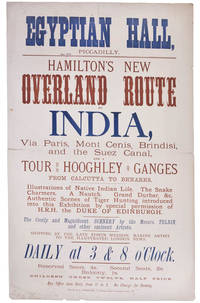
99252London Printed by S. Golbourn February 1876. . Broadsheet 51.25 x 31.4 cm printed in blue and tan horizontal centre fold short split short splits to head a good example.<br /> Rare broadsheet advertising an exhibition at the Egyptian Hall. The Egyptian Hall was a leading venue for exhibitions featuring original artwork and relics.<br /> London, Printed by S. Golbourn, February 1876. unknown
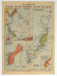
1944208880Chicago.: Chicago Daily Tribune. 28 September1944. Colour pictorial map on a single newspaper leaf archivally laid down on linen 50 x 39.2 cms; 59.3 x 43.3 cms sheet including captions faint toning to fold lines very good condition. Vivid colour maps of the Palau Islands Guam and Saipan in the Marianas and an inset location map published in the "Chicago Daily Tribune" in September 1944 months after the landing of US and Allied Forces in the offensive against the Japanese during the Pacific War. . Chicago Daily Tribune. unknown
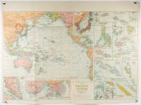
1930205997Sydney: H.E.C. Robinson. Circa1930s. Printed colour maps in all 65.5 x 99cm the main map roughly 50 x 65 cms on a single sheet 76 x 101.3 cms; a little carelessly folded decorative blue title cover a little dusty and a few fold splits and edgewear but in good condition. The exceptional feature of this map are the twenty six large scale inset maps of Pacific islands including: Malay States Singapore Hong Kong these at lower left Japan Philippine Islands Hawaiian Islands Fiji Solomon Islands Western and Eastern Samoa Tahiti Saipan New Caledonia and Dependencies and many others. <br> <br>The main map of the Pacific Ocean stretches from Southeast Asia including all of Australia and New Zealand the west coast of the Americas the Kamchatka Peninsula Manchukuo Manchuria and most of China. Korea and Taiwan are marked as Japanese Territory. Possessions of Britain France the Netherlands and the United States are highlighted. <br> <br>An incredibly rich source of information on the Pacific theatre during the years leading up to World War II. From the Sydney publisher H.E.C. Robinson the firm founded in 1895 by Herbert Robinson 1857-1933 a founder of the Royal Geographical Society of Australasia. . H.E.C. Robinson. unknown
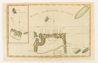
1784174895London.: Alexander Hogg at the King's Arms. circa1784. Engraved map on laid paper 21.4 x 33.7 cm inset of Gower's Simson's and Carteret's Island early outline hand colour trimmed to the plate mark at the top edge three small edge tears affecting the upper margin only slight paper toning but a most attractive map in very good condition. Fine impression of the Queen Charlotte's Islands Solomon Islands. It features the Swallow's track the ship's route taken by Captain Philip Carteret in 1767 the British naval officer and explorer who participated in two of the Royal Navy's circumnavigation expeditions in 1764–66 and 1766–69. . Alexander Hogg at the King's Arms. unknown
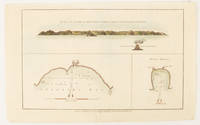
1784174896London.: Alexander Hogg at the King's Arms. circa1784. Engraved map in triptych on laid paper 20.1 x 32.7 cm three insets: cross section of the north side of Queen Charlotte's Islands Solomon Islands with detail of a volcano "6 leagues North"; Swallow's Bay Harbour; and Byron's Harbour early hand colour trimmed to the plate mark at the top edge neat sealed tear affecting the publisher's caption slight edge wear and paper toning but a most attractive map in very good condition. Attractive engraving of the Queen Charlotte's Islands Solomon Islands. The Islands were named for the consort of King George III by Philip Carteret the British naval officer and explorer who participated in two of the Royal Navy's circumnavigation expeditions in 1764–66 and 1766–69. His ship the Swallow gave her name to the Bay and Carteret's commanding officer on the first of his voyages John Byron to the Harbour depicted in this most attractive early chart. . Alexander Hogg at the King's Arms. unknown
13821Sans lieu, Chemins de fer Paris-Lyon-Méditerranée, sans date. Plaquette in-12 brochée de 31 pages, couverture illustrée.
201602773Paris, MON JOURNAL - aventures et voyages, s.d. ; in-12, 130 pp., broché, couverture illustr. Bon état -.
201602772Paris, MON JOURNAL - aventures et voyages, s.d. ; in-12, 130 pp., broché, couverture illustr. Bon état -.
201602774Paris, MON JOURNAL - aventures et voyages, s.d. ; in-12, 130 pp., broché, couverture illustr. Bon état -.
201102848Paris, MON JOURNAL - aventures et voyages, s.d. ; in-12, 130 pp., broché, couverture illustr. Bon état -.
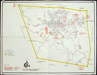
1960206510circa1960. Printed pictorial map 44.8 x 58 cms 46.7 x 60.3 cms sheet original folds a little wear but in very good condition. Attractive 1960s tourist map of Baguio city when it was the "Summer Capital" of the Philippines. Tourist attractions are shown pictorially in red blue triangles denote wood carving shops the city boundaries outlined in yellow sealed and unsealed roads are also shown. . unknown