4 345 résultats
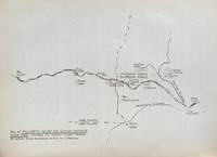
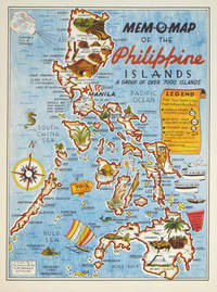
1945204557U.S.A.: Mem-O-Map Co. 1945. Colour pictographic / pictorial map 32.1 x 23.8 cms; 35.4 x 26.6 cms sheet very good condition. Rare pictorial map published in 1945 by John G. Drury aTechnical Officer who served with the 214th Ordnance Battalion to mark the end of World War II as souvenirs for the military. Military personnel could fill in banners "came in on good ship." and "departed on good ship." their name organisation and "Line of Advance or movement" blank in this example. Pictographs mark various memorable spots and wildlife including larger-than-life insects. A "Terrible Tillie Typhoon" looms over the coast at Luzon. <br>Drury published a series of five maps: Philippines and Okinawa in 1945; Japan and Korea Oahu and Europe in 1946. They are all scarce. “These almost whimsical maps are designed to support the creation of personalised geographies. At a time when digital mapping is beginning to experiment with the creation of personalised content that would render the same map in different ways for different users Mem-O-Maps demonstrate the principle in action." Kenneth Field ICA Commission on Map Design. . Mem-O-Map Co. unknown
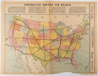
1938215547Los Angeles.: Los Angeles Examiner. Sunday 1 May1938. Printed colour pictorial map 33 x 48 cms; 41.8 x 54.5 cms sheet central fold sheet toned corners chipped with some loss to the bottom border and at the central fold in good condition; and on the verso "Movie-Go-Round" by Louella O. Parsons black and white photos and advertisements. Pictorial map printed for the weekend supplement of the Randolph Hearst owned newspaper the Los Angeles Examiner. The map-maker and artist Howard Burke had also worked for the San Francisco Examiner and was known for pictorial maps many with a persuasive or rhetorical edge and as here were designed to shore up American patriotism and defences against a wider world in the increasingly turbulent pre-war 1930s. The caption to this map outlines a multi-billion dollar 25 year proposal by Congressman J. Buell Snyder for a network of coast to coast transcontinental highways "in case of an attack by a foreign power at any point along the border". Buell Snyder earned the soubriquet "the father of superhighways" and during the War he was assigned to a Congressional Committee in charge of appropriations for the War Department. Scarce. . Los Angeles Examiner. unknown
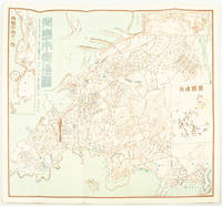
1572171093Qingdao: Taiheiyoko. 太平洋行. 昭和 13 1938. Coloured folding plan of Qingdao in 1938. some browning on reverse with a small lighter section on map Japanese place names no scale 36 x 39cm 3 inset maps. This 1938 Qingdao city map shows street names in Chinese characters and location of Chinese and Japanese public buildings such as the hospital shrines Japanese primary schools and high schools. The 3 inset maps show railway and transport routes as well as outskirts of the city. . [Taiheiyoko]. 太平洋行. unknown
3001Trenton: The Company; Press of the Emporium 1846. . 8vo self-wrappers side-stitched Not found in OCLC. Trenton: [The Company]; Press of the Emporium, 1846. unknown
3006Milwaukee: The Company; Daily News Book and Job Steam Printing Office 1857. . 8vo yellow wrappers front printed This is not a later printing of Library of Congress Modelski No. 440. There is no inset and the copyright is 1856 Milwaukee: [The Company]; Daily News Book and Job Steam Printing Office, 1857. unknown
200817469Lausanne, Cristal&derib, 1988 ; in-4, 60 pp., cartonnage de l'éditeur. Eo tome 1.
200817468Lausanne, Cristal&derib, 1988 ; in-4, 60 pp., cartonnage de l'éditeur. Eo tome 1.
200817467Lausanne, Cristal&derib, 1988 ; in-4, 60 pp., cartonnage de l'éditeur. Eo tome 1.
200809789Lausanne, Cristal&derib, 1988 ; in-4, 60 pp., cartonnage de l'éditeur. Eo tome 1.
9979GRAND' ROUTE. N° 4. (Juin 1930). André Cayatte, Philippe Lamour, Eric B. Hurel, Filippo Burzio, René Laporte, Jacques Dalleas, Pierre Scize, Henri Lens,W. Gebrowsky. /// Dessin de Mayo. /// Couverture et dos défraîchis ; propre intérieurement. Rare.
190060562Buffalo NY: Kellogg Iron Works ca. 1900. Oblong 8vo. 9.5 x 6 in. 16 pp unpaginated. printed photo plate followed by plates of elevations and bridge plans. Original gray printed softcovers black lettering front cover minor corner chip to first page couple closed tears w/ minor repairs dustsoiling to fore-edges still a VG- copy. First edition of this exceedingly scarce catalogue of touting “Kelloggâ€truss bridges which consisted of Pratt inner bracing with additional diagonals and were popular in the Northeast at the end of the 1800’s until about 1901-1905 spanning between 75 to 150 feet. These types of bridges played a crucial role in road building driven by the Good Roads Movement during the opening decades of the 20th century. At the end of the 19th century less than 50% of roads within American cities were paved and the very few highways and turnpikes connecting cities and towns were little more than crushed rock macadam dirt roads or even paths. Although founded in the 1880s by bicycling enthusiasts the Good Roads Movement at the beginning of the 20th century began to be driven largely by advocates of the automobile who favored sturdy durable bridges which could be easily maintained. These Kellogg truss bridges featured riveted steel trusses and were often anchored in stone foundations. Charles H. Kellogg the elder was an active bridge engineer and builder whose firm wen through several different configurations and owners between 1870-1915 while his son Charles H. Kellogg the younger operated his own company from 1891-1901 and should not be confused with the short-lived Kellogg Iron Bridge Works Co. which was using the Union Bridge Company’s shop. No copies in Worldcat; See: Mead & Hunt Contextual Study of New York State’s Pre-1961 Bridges pp. 23 & 93 1999. Kellogg Iron Works, paperback
191862523Peoria IL: Avery Company Manufacturers 1918. 4to. 24 pp unpaginated. printed in red gray & black throughout. Photo text illustrations throughout decorative borders illustrations. Self-printed colour-illustrated softcovers cover art of Avery road tractors and scrapers front & back minor edgewear creasing minor wear & dustsoiling w/ tiny closed tears at spine still VG- copy. First edition of this uncommon catalogue of equipment which played a crucial role in road building driven by the Good Roads Movement during the opening decades of the 20th century. At the end of the 19th century less than 50% of roads within American cities were paved and the very few highways and turnpikes connecting cities and towns were little more than crushed rock macadam dirt roads or even paths. Sidewalks were nearly unknown and unlike Europe road construction was not primarily managed by national or local governments. Although founded in the 1880s by bicycling enthusiasts the Good Roads Movement at the beginning of the 20th century began to be driven largely by advocates of the automobile. This catalogue illustrates Avery road tractors graders scarifiers blades drag scrapers and more building roads in Texas Oklahoma Idaho Nebraska Kansas Indiana and more. The Avery company was founded initially in Galesburg IL following the Civil War by Robert and John Avery with Robert as the ever-intrepid inventor and machinist one of whose earliest inventions was the riding cultivator. By 1883 and teamed up with his brother Cyrus the company proved successful and after 1892 became well-known for their internal combustion engine equipment. By 1920 the company led by Bartholomew employed 4000 people and pioneered motor cultivators and road-building equipment but was hit by the post-World War I depression about the time this catalogue was issued and although the company attempted to reorganize and laid off 90% of its workforce it failed by 1923 and was renamed the Avery Power Machinery Co. The company limped through the Great Depression and closed finally in World War II. No copies in Worldcat; See: Mowitz The Once-Great Tractor Innovator Lost to Time Successful Farming Nov. 20 2024. Avery Company Manufacturers, paperback
192859837Chicago IL: The Austin-Western Road Machinery Co. 1928. Oblong 4to. 11.2 x 8.25 in. 60 pp. Colour-tinted decorated title colour-tinted borders throughout some illustrations w/ colour-tinting 100s of photo & text illustrations some full page. Colour-illustrated softcovers cover art illustration of beautifully built highway with towering trees and Austin-Western road grader smoothing road in front of picturesque bungalow w/ mountains in the distance minor shelfwear rubbing still NF copy w/ promotional sheet detailing the equipment in this catalogue on Austin-Western Road Machinery Co. letterhead. First edition of this scarce catalogue of equipment which played a crucial role in road building driven by the Good Roads Movement during the opening decades of the 20th century. At the end of the 19th century less than 50% of roads within American cities were paved and the very few highways and turnpikes connecting cities and towns were little more than crushed rock macadam dirt roads or even paths. Sidewalks were nearly unknown and unlike Europe road construction was not primarily managed by national or local governments. Although founded in the 1880s by bicycling enthusiasts the Good Roads Movement at the beginning of the 20th century began to be driven largely by advocates of the automobile. In 1901 the F.C. Austin Manufacturing Co. and the Western Wheeled Scraper Co. which had been fierce competitors formed a selling corporation known as Austin-Western Road Machinery Co. The company specialized initially in building scrapers but during the opening decades of the 20th century began producing wheel graders patrol graders self motor graders snow plows rollers dump wagons gutter cleaners and even asphalt hot patch outfits all shown in this catalogue. In 1916 just 12 years before President Wilson had signed the Federal Aid Road Act enabling America to embark on a truly national highway and road construction campaign that continued to the end of the 1920s. No copies located in Worldcat; See: Austin-Western Road Machinery Grader History 2017; Thomas Berry Austin-Western Road Machinery Company 1905-1936 Historical Construction Equipment Association 2005. The Austin-Western Road Machinery Co., paperback
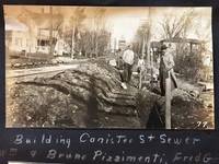
191353568Hornell NY & Low Moor VA: Homer A. Sitterley Asst. City Engineer for Hornell NY; Chief Mining Engineer Low Moor Iron Co. 1913-1917. Oblong 8vo. 10 x 7 in. 142 pp unpaginated. thick black paper stock w/ 298 original photographs sized from 2 x 3 in. up to 3.25 x 5.5 inches 280 this size 2 of them cyanotype and the majority with neat white ink manuscript descriptions linen-backed frontisp. map of Hornell NY dated 1915. Contemporary limp black-cloth post-binder sewn at gutter margin w/ black silk braid minor soiling tidemark to outer fore-edges of front cover first couple leaves minor fraying & wear to corners still a VG- exemplar w/ most images with strong contrast. This remarkable album documents the tremendous range of road building projects sewer improvements bridge building and dam construction in and around Hornell NY in Steuben County in the years before World War I. Steuben County was the next to the last County in New York State to join the Good Roads Board sponsored by the American Automobile Association in 1907 primarily because during the opening decades of the 20th century that area of New York had some of the worst roads. These images show the construction and building of sewer lines on Crosby Street Canister Street paving projects on East Ave. Jane Street West Street -- with fantastic images of early Foote Concrete Machinery Co. road paver in operation pouring concrete West Genesee Street Church Street and others. Sitterley b. 1889 makes a study of the filtering systems and sewer plant for New York City at the time includes photo of the newly opened Hornell trolley “Subway†as well as numerous photos of poor condition sidewalks which were slated for modernization as an adjunct of the Good Roads agenda hand-in-hand with laying of new sewer lines. In addition he has included photo of himself with surveyor’s transom and the Hornell City Engineer together with the City Park Superintendent. A significant portion of the album is devoted to the building of the Seneca Street Bridge including the building of the coffer dams to hold back the water to pour the piers the construction of the abutments and finally the finished bridge. That bridge would later be rebuilt by a WPA project in 1936 and now is up for replacement again. Sitterley’s last major projects were overseeing the building of the new Hornell city dams and city reservoirs together with road improvements gate houses and spillways. In March 1916 he leaves Hornell NY to become Chief Mining Engineer for the Low Moor Iron Co. which was a producer of pig iron in Alleghany County of Western Virginia which operated from 1872-1930. The company was often plagued with labor unrest as they maintained very poor “Company†towns and were constantly struggling with the Chesapeake & Ohio Railroad to ship their ore. In 1916 they were on the upswing as a company as the growing steel demands of World War I began to lift all ore producers at the time. See: Corning Convention of Good Roads Associations Good Roads Magazine April 1907 pp. 134-135; Homer Aldrich Sitterley Bi-Monthly Bulletin of the American Institute of Mining Engineers No. 126 June 1917 p. xxxv; Russell Story of the Great Flood and Cyclone Disasters in New York State 1913 New York Roots 1999; Papers of the Low Moor Iron Company 1873-1927 Special Collections Univ. of Virginia Library 2010. Homer A. Sitterley, Asst. City Engineer for Hornell, NY; Chief Mining Engineer, Low Moor Iron Co., hardcover
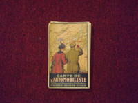
1914106329<p>Folding road map 22" x 34" folding into a 7" x 4 1/2" pocket type road map color illustrated title front cover with add panels on the reverse. Some tears at folds one panel split at fold some aging browning and soiling; otherwise a bright impression in pretty good condition. An attractive and somewhat scarce European roadmap. The map is French and shows roads available for motoring between France Italy and Switzerland. The OCLC locates only a couple of copies. OCLC. </p> Kummerly & Frey,
179521089Brest 1795 1 feuillet avec en-tête préimprimé en noir : Liberté Egalité Fraternité et orné d'une vignette en noir (avec symboles révolutionnaires : faisceaux d'Armes et bonnet Phrygien et marianne), manuscrit à l'encre brune sur papier vergé bleuté ligné filigrané, format 19,8 centimètres de large par 31,5 centimètres de haut, Lettre écrite à ROCHEFORT, le 9 Prairial, An 3, de la République Française, une et indivisible, signature manuscrite de LELARGE,
179521092Brest 1795 1 feuillet avec en-tête préimprimé en noir : Liberté Egalité Fraternité et orné d'une vignette en noir (avec symboles révolutionnaires : faisceaux d'Armes et bonnet Phrygien et marianne), manuscrit à l'encre brune sur papier vergé crème ligné filigrané, format 18 centimètres de large par 24 centimètres de haut, Lettre écrite à ROCHEFORT, le 13 Germinal, An 3, de la République Française, une et indivisible, signature manuscrite de LELARGE,
201503909Paris, Hermès, 2003 ; in-4, 269 pp., br.
201227969Paris, Eyrolles, 1972 ; in-8, 215 pp., br. Bon état.
193859631Portland OR: Works Progress Administration of Oregon ca. 1938. 4to. 4 pp. 41 leaves unnumbered. including mimeograph map embossed “Mimeograph†paper watermark at fore-edges of some leaves. Contemporary quarter simulated calf over embossed “Writing Portfolio†boards fuzzy textured brown endpapers light interior uniform toning scuffing edgewear very faint off-gassing odor still VG exemplar from library of Alfred Powers. First edition of No. 5 in the Historical Records Survey of Oregon series reproducing and detailing the intricacies of the preserved original abstract of the Willamette Valley & Cascade Wagon Road Co. held in Prineville OR. WV & CWR Co. The Wagon Road co. was originally incorporated in March 1864 by Luther Elkins D.W. Balland Morgan Kees John Settle and others opening a route connecting Albany OR with the bunchgrass range in Central Oregon. The toll road was finally finished by 1868 using Chinese-American labor with Jason Wheeler overseeing construction and later J.A. White. In 1884 C.E.S. Wood began practicing law in Portland OR specializing in maritime and corporate law as well as serving as land agent for Lazard Freres the New York banking firm controlling the WV & CWR Co. wagon road grant stretching from Albany OR to the Idaho border. Subsequent to the details included in this abstract Wood would negotiate the sale of the wagon road to Louis HIll son of railroad tycoon James J. Hill and the million-dollar commission allowed him to retire and relocate to northern California with Sara Bard Field. The wagon road was converted to US Highway 20 the Santiam Highway and completed in September 1939. Worldcat locates 8 copies LA Nat Hist. Mus Boise SU OR Hist. Soc. Lib. U of W Wash State Lib. Yale OR State Lib. U of O; See: Bingham Charles Erskine Scott Wood 1990 pp. 8-9 47; See: Griffith Works Progress Administration Oregon June 1936 p. 10. Works Progress Administration of Oregon, hardcover
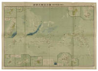
1819155215統正社 Tōseisha . Showa 18 1943. Colour folded map 54. x 76.5cm. Pinholes at corners light even browning good copy. This Japanese map of Micronesia shows the Mariana Islands Eastern and Western Caroline Islands Marshall Islands and Gilbert Islands. The separate maps around the edge are clockwise from the upper right corner: Jaluit Atoll Guam Island Rota Island Saipan Island Palau Islands Yap Island Hall Islands Pohnpei Island Truk Islands and Kusaie Island. . 統正社 [Tōseisha ]. unknown
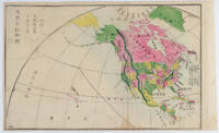
1877159812Kyoto.: 村上勘兵衛 文部省刊行. Murakami Kanbē; Monbushō kankō. Meiji 10 1877. Colour woodblock map of North and Central America. From the Journal of World Geography 萬國地誌略 published in 1877. Printed area measures 33.5 x 21cm a good copy with occasional soiling. . 村上勘兵衛, 文部省刊行. [Murakami Kanbē; Monbushō kanko& unknown
2001LFA-126741204Une revue de 12 pages, format 220 x 285 mm, illustrée, brochée couverture couleurs, Editions Atlas, bon état
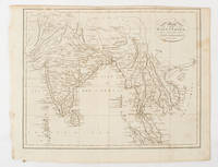
1805175148London & Glasgow.: W. and D. Brownlie. 1805. Engraved map 18.7 x 23.9 cm original folds age toned and spotted inner margin a trifle ragged paper thinning in a few spots in good condition. Attractive map engraved for "A System of Geography; or A Descriptive Historical and Philosophical View of the Several Quarters of the World" published in 1805. . (W. and D. Brownlie) unknown
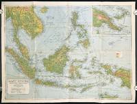
1940211106Sydney.: H.E.C. Robinson Pty. Ltd. circa1940. Full colour folding map 71 x 97 cms; 76.2 x 10² cms sheet blank on verso save for a neat inked stamp "East Indies" inset map of New Guinea and Papua heights shown by colour very good clean condition. Large scale World War II era map by Sydney publisher H. E. C. Robinson. Extremely detailed map it is coloured according to height above sea level and showing naval bases railways shipping routes air routes. Includes smaller inset map of "New Guinea & Papua" showing the eastern part of the island. . H.E.C. Robinson Pty. Ltd. unknown