Santiago EstradaBiblio.com
190 résultats
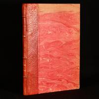
1866829B27Victoria: Imprenta del Siglo 1866. First edition. Leather. Good. 10" by 7". none . A scarce first edition copy of Santiago Estrada's short story that celebrates nature in the original Spanish. A scarce first edition copy of this work in the original Spanish. This is a short story by Santiago Estrada meaning The Home in the Pampas. The story aims to present a picture of the charms that can be found in the solitude of the fields and the beauty of nature. In quarter morocco with marbled covered boards. Externally generally smart with some fading to the boards and some marks to the spine. A library stamp and previous owner inscription to the page after the half title page. Internally firmly bound with generally clean pages which are a little age toned. Good Imprenta del Siglo hardcover
187524088Chicago: Beach Barnard & . Legal and mmercial Printers 1875. 35 1 blank pp. Original printed wrappers light dust and wear disbound four punch holes in blank left margin. Last few pages include charts trimmed a bit closely a few digits lost at edge of each line of one chart. Good. offered with ----TO THE HONORABLE THE JUDGE OF SAID COURT IN CHANCERY SITTING: THE RECEIVER IN THE ABOVE ENTITLED CAUSE RESPECTFULLY REPORTS TO THE COURT THE RECEIPTS AND DISBURSEMENTS ON ACCOUNT OF THE PROPERTY IN HIS CHARGE FROM APRIL 30TH 1877 THE DATE OF HIS LAST REPORT TO AUGUST 31ST 1877. 16pp. Caption title as issued disbound punch holes in blank inner margin. Light edge chipping and dusting. Good. offered with -----IN THE UNITED STATES SUPREME COURT OCTOBER TERM A.D. 1881. THE CHICAGO DANVILLE & VINCENNES RAILROAD COMPANY AND JAMES W. ELWELL APPELLANTS V. WM. R. FOSDICK AND JAMES D. FISH TRUSTEES APPELLEES. APPEALS FROM THE CIRCUIT COURT OF THE UNITED STATES NORTHERN DISTRICT OF ILLINOIS. PETITIONS FOR RE-HEARING AND SUGGESTIONS IN SUPPORT THEREOF. LAWRENCE CAMPBELL & LAWRENCE COUNSEL FOR PETITIONERS. Beach Barnard & . Legal Printers. 1882. 73 1 blank pp. Original printed front wrapper lightly age toned small hole in blank margin old ink inscription at head disbound four punch holes in left margin. Light vertical crease else Very Good. offered with ----- APPEALS FROM THE CIRCUIT COURT OF THE UNITED STATES NORTHERN DISTRICT OF ILLINOIS. SUGGESTIONS TO SUPPORT PETITION FOR RE-HEARING. HENRY CRAWFORD SOLICITOR. Beach Barnard & . Legal Printers. 1882. 38pp. Original printed front wrapper bottom corner chipped ink inscription at head disbound four punch holes in left margin. Text lightly age toned small chip to bottom corner of last page. Very Good. The suit originated in March 1875 on the issue of the Road's nonpayment of bond interest. Fosdick and Fish sued the Chicago Danville & Vincennes Railroad. Beach, Barnard & ., Legal and mmercial Printers unknown books
183539444México: Impreso por Ignacio Cumplido 1835. Paperback. Good. 44p wrps. Gutiérrez Estrada 1800-1867 was Secretary of Interior and Exterior Relations under Santa-Anna and Barragán in 1834 and 1835. Here he explains and documents that his resignation was not an attempt to discredit the government but to respond to his federalist convictions. Later he was forced into exile served as ambassador in several posts and was named head of the commission to offer the throne of Mexico to Maximillian. Impreso por Ignacio Cumplido paperback
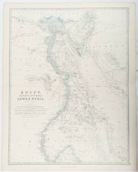
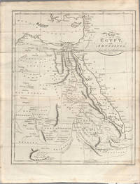
1861177021Edinburgh & London.: William Blackwood & Sons. 1861. Engraved map with original outline hand-colour 57 x 43.8 cm 61.1 x 49 cm sheet central fold very slight edge toning but the map in very good bright condition. First edition. Fine large folding map: the Nile delta and river with attractive original outline colour railways and canals marked and name references to biblical and classical geography. Published for inclusion as map 39 in "Keith Johnston's royal atlas of modern geography" . William Blackwood & Sons. unknown
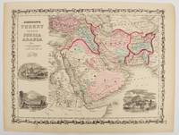
1860177019New York.: Johnson & Browning. circa1860. Engraved map 30.2 x 40.5 cm 34.5 x 45.5 cm sheet original hand-colour elaborate strapwork border three fine vignettes of Muscat Trebisond small marginal edge tears top corner chipped the map in very good condition. Most attractive decorative map of Arabia the Ottoman Empire Persia Afghanistan Beloochistan and surrounds by one of the most popular and successful 19th Century American atlas publishers. . Johnson & Browning. unknown
1805175148London & Glasgow.: W. and D. Brownlie. 1805. Engraved map 18.7 x 23.9 cm original folds age toned and spotted inner margin a trifle ragged paper thinning in a few spots in good condition. Attractive map engraved for "A System of Geography; or A Descriptive Historical and Philosophical View of the Several Quarters of the World" published in 1805. . (W. and D. Brownlie) unknown
1840174957London.: Charles Knight & Co. circa1840s. Lithographed map with original outline hand-colour 31.9 x 39.1 cm small marginal tears neatly repaired with archival material but no loss small surface abrasion affecting the border at the foot edgewear and browning inked pagination in an early hand but in very good condition. A handsome map with fine topographical engraving also showing the borders with Hungary Russia and Persia. . Charles Knight & Co. unknown
1862111032294Printed by R. & R. CLARK Edinburgh: PRINTED FOR PRIVATE CIRCULATION 1862. Book. Fair. Hardcover. First Edition. 12mo - over 6¾ - 7¾" tall. Age-toned cover with black border and chocolate endpapers gilt spine title and gilt - In Memoriam. 1862 at front cover center. Fair condition with partially re-glued inner spine to text block and old tape at the inside front. Some page sections have been moved slightly forward from the binding and there is a separation at the contents gutter. The cover is spotted and sunned with frays at the corners and the pages are lightly foxed. Whole page 1863 associated related inscription at the half-title page with a 1971 inscription below from another relative. Pasted picture of his wife opposite the title page. Civil War era book. 7 x 4 1/2 with 133 pages. Rare. PRINTED FOR PRIVATE CIRCULATION Hardcover
18891933PRIMERA EDICION.- Barcelona: Imp. Henrich y Cia. 1889.- XIII276 p.; en 4º. 23 cm.- Interesantes biografÃas americanas: Santiago Liniers; Félix FrÃas amplio estudio biográfico; Mi padre; El Tte. General Pedernera; Domingo Sarmiento.- CONTINUA EN EL MISMO VOLUMEN: ESTRADA Santiago.- Discursos / Precedidos de una introducción de D. Santiago Liniers.- Barcelona: Imp. Henrich y Cia. 1889.- XV327 p. 1 h.; 4º 23 cm.; Las 2 obras encuadernadas en un solo volumen en Media Piel de la época.- RARO. El lomo restaurado de un desgarro en la cabeza y algunas pequeñas rozaduras. En la portadilla lleva estampado un pequeño sello tampón del anterior propietario. Las portadas con mÃnimas y tenues motas de óxido. Dicho esto que es preceptivo el libro se encuentra por lo demás en muy buen estado. HISTORIA POLÃTICA Y DERECHO POLÃTICO-INTERNACIONAL AMERICANOS DESDE LA INDEPENDENCIA Libro en español Imp. Henrich y Cia. hardcover
1803174955London. circa1803. Engraved map 23 x 18.5 cm original folds small split to one fold affecting the margin only paper age- toned lower corner darkened and on the verso inked circles to the lower half in an early hand but in good condition. Finely engraved early 19th Century map also showing to the north Syria Palestine and Cyprus and Darfur and Mountains of the Moon Sources of the Nile to the South. . unknown
1819162103Tokyo.: Tōseisha. Showa 18 1943. Folding colour map of Australia 54.2 x 76.4cm. Some foxing particularly along folds and upper right margins a few repaired tears and small holes at folds.With original sleeve. The 15th map in the Standard Maps of Greater East Asia series of 20 maps. Shows the natural resources such as sheep gold pearl diary regions opals etc. Tasmania appears as an inset in the bottom right corner. Text in Japanese. . Tōseisha. unknown
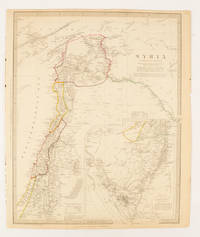
1843174934London.: Chapman & Hall. 1843. Engraved map with outline hand colour 39.4 x 31.4 cm inset map "Continuation from the Dead Sea to Mount Sinai" with finely engraved notes and a key to the Divisions under control of the Turkish Government manuscript pagination in an early hand to the top right edge tear nicks and browning but in very good condition. A most attractive map with detailed notes published when Syria was still under control of the Ottoman Empire. . Chapman & Hall. unknown
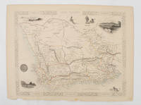
1851174666London.: Tallis John. 1851. Lithographed map 24.2 x 32 cm districts picked out in original hand colour inset vignette illustrations decorative border lower margin ragged but the attractive map in very good condition. Attractive decorative map from "Tallis's illustrated atlas and modern history of the world." one of the last great illustrated series of world maps. The fine vignettes are of Cape Town Graham Town and entrance to the Knysha Heads. . (Tallis, John). unknown
18972605120102Philadelphia: Armstrong & Fears 1897. 10. Maps. Very Good. Double sided foldout colored map 43 x 39 cm labelled "L.A.W. Local cycling Map" and colored corresponding to the road type. 79 p. Includes: an official list of consuls hotels and repair services in the area that acts as a very early example of a travel coupon. Pages include routes from Adamsville to Zionsville with route maps and information about the views road conditions and recommendations from riders. <br>Published to capitalize on the bike boom of the period where recent innovations in safety components and reduction of manufacturing costs made bicycles more commercially available and bike clubs sprung up across the country. Philadelphia was one of the centers of this Bike Boom due to it's relatively flat cityscape and was home to some of the most prominent cycling clubs. The League of American Wheelman was one of the most prominent with 103000 members in 1898 the year after this map was published. The league of American Wheelman still exists to this day. <br> Catalogued by Anastasia Rittenhousesmith. Armstrong & Fears unknown
188210744Paris, s.n., novembre 1882 ; in-folio, broché ; 59 pp., couverture grise imprimée, 75 plans côtés, texte manuscrit lithographié.
1835203763Philadelphia.: W. Marshall. Circa1835. Handcoloured engraved map 26.5 x 41.3 cms; 29.6 x 48.3 cms sheet central fold insets of "Oceanica" and "New Holland" central table some light staining in the image and margins in good condition. Eurocentrism laid bare. This 19th Century map includes a "State of Society" for each part of the world declared with a symbol to represent "Barbarous Half Civilized Civilized and Enlightened Societies" as well as noting religion and ethnicity. It includes a table of distances between chief towns or capitals and between these towns and Washington DC. Australia "New Holland" is styled principally as pagan barbarous unexplored and African a thin sliver of what is now New South Wales and Victoria is labelled civilized European and Protestant. Scarce. . (W. Marshall). unknown
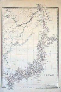
1852185246London.: Cassell Petter & Galpin. circa1852. Map with outline handcolour 42.5 x 30.1 cms; 49.2 x 34.3 cms sheet margins a little toned small corner crase but in very good condition. Very detailed map of the Japanese islands with Sakhalin above and the coast of Manchuria and Korea. . Cassell, Petter & Galpin. unknown
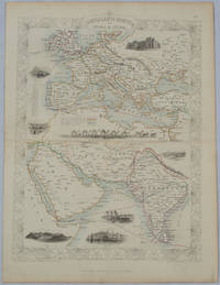
1850177525London.: The London Printing and Publishing Company. circa1850s. Lithographed map with original outline hand colour 33 x 24.5 cm including border and captions seven vignette illustrations two reference keys decorative border central fold light toning mainly at the central fold and to the verso of the sheet in very good condition preserved in a window mount. Attractive decorative map with fine vignettes of the London Post Office Suez Bombay Madras. Aden Malta Gibraltar and a wonderful camel train led by a carriage and horses crossing North Africa originally by the great mapmaker and publisher John Tallis. The two reference keys note steam packet routes railways electric telegraph and the Suez Canal. . The London Printing and Publishing Company. unknown
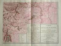
1805570721805. Copper engraving with handcolouring map shows the border of the Austrian Empire and Hungary Vienne sic and the Danube can be seen at the top of the map Two keys and scale inset. Few closed tears and some browning edges otherwise a clean and bright image. Map measures approximately 34 x 44cm. Map of Germany <br>indicating the present division of this empire as well as the new possessions of the princes who make up the Germanic body and including Batavia and Helvetia Switzerland with their divisions. by E. Mentelle a member of the institute and P. G. Chanlaire one of the authors of the National Atlas. An xiii 1805. Paris. There is a key to the explanation of the signs and an explanation of the colours used for the district of the various states contained in this map. . unknown
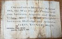
185836085Augusta: Georgia Rail Road 1858. Broadside. Fair. Broadside. Approximately 5" x 7.5". Paper is folded creased toned with two small holes. Tears at the splits. Tape repair on the blank reverse side. Fair condition only. Obscure. No other copies of this advertisement were found during a recent search. Georgia Rail Road unknown
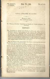
183928837Washington 1839. 25th Cong. 3d Sess. H.Rep.322. 167pp disbound. Six folding maps and chart. Several text leaves browned Very Good plus. <br /> <br /> Reviewing proposals and data for a canal route including a memorial from Matthew Carey. <br /> Morrison 5 noting only 3 maps. unknown
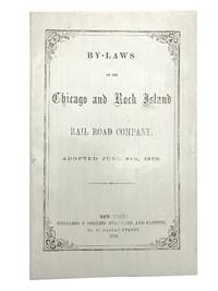
185830039New York: Benjamin Corlies 1858. Original printed glossy wrappers light fading to lettering. Stitched. 10 2 blanks pp. Near Fine.<br /> <br /> Founded in 1847 as the Rock Island and LaSalle Rail Road Company the Chicago and Rock Island reincorporated in 1851 and adopted these bylaws in 1858. In 1880 the Company was reorganized as the Chicago Rock Island and Pacific Railway. <br /> 131 Eberstadt 354. Benjamin Corlies unknown
1858406267New York: Benjamin F. Corlies 1858. A very good to near-fine copy with one closed tear and some light discoloration to the wrappers. 8vo. 10 pages. Original glazed-paper printed wrappers. Nine articles outline the structure of the company which had formed in 1847 as the Rock Island and LaSalle Rail Road Company and reincorporated under its new name in 1851. OCLC 4997635. Eberstadt catalogue 131 item 354. <br/><br/> Benjamin F. Corlies unknown books
185830039New York: Benjamin Corlies 1858. Original printed glossy wrappers light fading to lettering. Stitched. 10 2 blanks pp. Near Fine.<br/><br/> Founded in 1847 as the Rock Island and LaSalle Rail Road Company the Chicago and Rock Island reincorporated in 1851 and adopted these bylaws in 1858. In 1880 the Company was reorganized as the Chicago Rock Island and Pacific Railway. <br/>131 Eberstadt 354. Benjamin Corlies unknown books
183928837Washington 1839. 25th Cong. 3d Sess. H.Rep.322. 167pp disbound. Six folding maps and chart. Several text leaves browned Very Good plus. <br/><br/> Reviewing proposals and data for a canal route including a memorial from Matthew Carey. <br/>Morrison 5 noting only 3 maps. unknown books