2 067 résultats
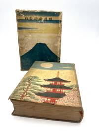
192686404Tky Tokyo: Hakubunkan 1926. Fine. Hakubunkan Tky Tokyo 1926 19.50 x 11 cm relié Work published by the Japanese Ministry of Railways admirably illustrated with 166 illustrations. This new edition was entirely revised and the illustration is completely new. The Ministry of Railways published this collection from 1923 to 1928; from 1923 to 1925 the collection contained numerous bird's-eye view maps by Yoshida which were replaced by photographs and now only adorn the pastedowns. This is the first collection to use photography with 126 black and white photographs and 18 hand-colored ones. 22 color prints by Hatsusaburo Yoshida. 7 folding color maps and several black and white maps in-text. Cloth binding and cardboard slipcase. Pale green cloth covers. Smooth spine with title. Boards printed with a Japanese temple with full moon and trees on the first board and on the second. Illustrated cardboard slipcase with Mount Fuji and birds. Rubbing and dulled edges to the slipcase. Small cut to the cloth on the spine. Fine condition of the collection with some foxing. Spine darkened boards spotted. Handsome copy rare with its original slipcase. A vast undertaking this guide was intended as a monument to the glory of Japan. For the first time modern Japan meets traditional Japan. Celebrated as the Hiroshige of the Taisho era Yoshida 1884-1955 was a painter and cartographer. A major retrospective of his works took place in Japan at the Sakai Museum in 1999. The prints created for this collection are particularly beautiful. Hakubunkan hardcover
186278773New York:: Francis Hart & Co. 1862. First edition. publisher's gilt-lettered and blind-embossed cloth. Small marginal chip to one map; cloth a little sunned; a beautiful clean tight and sound copy. . Folio. Decorative half-title page; engraved illustrations throughout; one double-page and one folding double-page map; engraved decorative borders throughout. . Francis Hart & Co., hardcover
1868173873Lille: Imprimerie de L. Danel 1868. Limited to 25 copies. Good overall the silk endpaper has lifted from the corner. 3/4/ black leather with 6 raised bands and gilt title second compartment. Purple silk endpapers and pastedowns. T.e.g. Title-page with large gilt-decorated emblem device above imprint. 3 preliminary leaves 7-97 2 pages mounted portrait. Preliminary states "Recueil des Discours Pronounces sur la Tombe du Baron James De Rothschild et des principaux articles de journaux publiées à l'occasion de sa mort et de ses funéreailles Ce Recuei tire vingt-cinq exemplaires est offert A Madame La Baronne James De Rothschild et a sa famille par le personnel du Chemin de fer du Nord." Includes funeral sermons and obituaries published in Le Temps Journal des debats L'Epoque and other perodicals. The photograph shows the Baron as he appeared in 1864. Worthy of restoration and exceedingly scarce. Worldcat locates 4 copies including 1 in the United States. Imprimerie de L. Danel hardcover
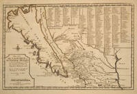
170015901Paris 1700. Early original color large map of California showing it as an island and based on the explorations of missionary Father Kino. From De Fer's Atlas Curieux. In great detail with 314 locations in New Mexico identified by a numbered key at the upper right portion of the map. Engraved by Charles Inselin. mage size: 13 1/2 x 8 7/8". Paper size: 16 1/2 x 11 1/2". With a small chip at lower edge; very faint damp staining at upper left corner toning to edges; otherwise very good. Tooley R. V. Amer P 126-7. unknown
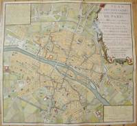
1735M7483Paris c.1735. Very Good;. Notes: Large scale decorative 18th century map of Paris. Top right title in a cartouche adorns a fountain spewing water referring to the establishment of the network of fountains in the capital. Size : 565x590 mm 22.24x23.23 Inches Coloring: Hand Colored Reference: Jean Boutier #212A Category: Maps Europe France Paris;Maps City Maps; unknown
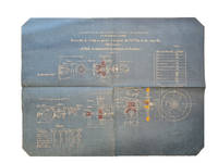
189159258Loire Saint-Chamond 1891. Folio. 45 technical drawings most printed and hand-coloured on blue paper. All plates depicts the "Tourelle à éclipse pour canon 1 Canon de 75 m/m á tir rapide". Sizes vary from 75x36 cm to 101x73 cm. All housed in contemporary portfolio front board detached. All plates with stamp and nubering in contemporary hand. Plates fine and clean. <br/><br/><em>Collection of techincal drawings of Saint-Chamond's fast 75 mm canon. The Compagnie des forges et aciéries de la marine et d'Homécourt FAMH Company of marine forges and steelworks and of Homécourt was a French industrial enterprise that made iron and steel products for the French navy army and railroads. It is often known as Saint-Chamond from its main location in Saint-Chamond Loire. </em> unknown
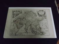
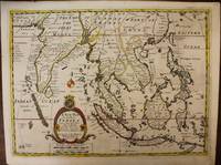
1722biblio10<p>Engraved double page map 28" x 20" wide margins hand colored in outline two uncolored pictorial cartouches. Expert and nearly invisible repairs along centerfold normal aging; about near fine. Impression is bright and clean. Nicholas De Fer 1646-1720 was a highly respected and prolific French cartographer whose maps were valued for their decorative appeal. Around 1690 he was made the geographer to the Dauphin and published his first atlas. He would become geographer to other high-ranking individuals in French and Spanish society. The present map is detailed and attractive map of Asia with a cartouche showing Chinese at the upper left and Indians in the upper right. The map covers a lot of territory showing Arabia and the Persian Empire in the West and Japan in the east but goes as far south as the Isle of Borneo and Java. Part of Eastern Europe is also visible. Library missouri website.</p>
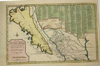
1705M5240Paris c.1705. Very Good. Notes: “California with indented northern coast and labeled: Californias o Carolinas. New Mexico is shown covered with engraved key at may top right. Includes Father Kino’s Place name Co. S. Francisco Xavier at California’s northern tip†McLaughlin<br><br>The title Ba. d. las 11000Virgenes is introduced for the first time. In the Southwest there are names such as Santa Fe Acoma and Casa Grande. The key covers 314 different places and their locations. Size : 230x345 mm 9x13.625 Inches Coloring: Hand Colored Reference: McLaughlin 134; Tooley Amer 62; Wagner 462. Category: Maps United States West California; Maps Central America Mexico; unknown
19252081502112400132Not Available 1925. Soft Cover. Fine. The book is in fine condition. Not Available paperback
18662092902144201629Not Available 1866. Soft Cover. Fine. The book is in fine condition. Not Available paperback
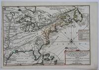
1705M4344Paris 1705. Excellent. Notes: This decorative map focuses on the French possessions in North America. The treatment of French Florida is intriguing. The map shows the United States of America and parts of Southern Canada East of the Mississippi river.<br>"Territorial expansion of New France had reached the Mississipi River with the establishment of the first European settlement at Fort Maurepas by Pierre Le Moyne d'Iberville in 1699 sixteen years after La Salle had reached the mouth of the river. This attractive map from 'L'Atlas Curieux ou le Monde' paris 1705 although containing geographical errors has many interesting historical notes" -The Macdonald Stewart Foundation Size : 232x342 mm 9.125x13.5 Inches Coloring: Hand Colored in Outline Reference: The Macdonald Stewart Foundation "La Decouverte du Monde Cartographes et Cosmographes" Map # 44; McCorkle 702.2 Category: ; Maps North America Great Lakes; Maps Canada; Maps Canada East; Maps United States East; Maps United States South unknown
1700M6975London c. 1700. Very Good. Notes: A late 17th Century map of South East Asia by Edward Wells based upon the previous work by De Fer. <br><br>The cartouche has the dedication in the coat of arms to the Duke of Gloucester. Size : 367x487 mm 14.45x19.17 Inches Coloring: Original Outline Coloring Category: Maps Asia South East; Maps Asia Central India & Sri Lanka / Ceylon; unknown
51-3483Paris: Nicolas de Fer circa 1693. 4to. 23 x 29cm. 18th Century rose cardboard covers. 33 engraved views and plans and 2 hand-drawn plans of Versoi and the col of Grand-Saint-Bernard showing Saint-Rhémy et San Leonardo. Old manuscript table of contents. Most of the plates are 17th Century but 2 are 18th Century. Small losses and browning to most plates.Nicholas de Fer 1646 – 1720 was the son of cartographer Antoine de Fer. Nicholas was established as an engraver cartographer and map publisher in Paris with over 600 maps and atlases to his credit. His work earned a large following because of its considerable decorative appeal. In the late 17th century de Fer’s career culminated in his appointment as Geographer to the King of France. Upon his death in 1720 Nicolas was succeeded by two of his sons-in-law Guillaume Danet and Jacques-François Danet and their heirs who continued the de Fer publishing firm until c. 1760. Recueil de 35 cartes plans et vues de villes fortifiées gravées sur cuivre 33 et manuscrites 2. S.l.n.d. Paris 1693 e.a. In-4 oblong cartonnage rose pièce de titre manuscrite Reliure vers 1800.Le présent ensemble contient :– 27 cartes et plans de villes fortifiées extraites pour la plupart de l'atlas de Nicolas de Fer 1693 montrant Turin Endingen Mont Royal Mayence Ath Pignerol Mont-Melian Landau Casal Verceil Genève Maestricht Huningue Nice Charle-Roy Bonn Calais Coblentz Stetin Juliers Wismar Mons Verüe Berg S. Winox Kamieniec Podolski Donquerque Coni ;– 4 vues gravées de Montmélian Miolans Verue Verrua Savoia et du siège de Genève ;– 2 planches manuscrites : un plan de Versoi et une carte du col du Grand-Saint-Bernard montrant Saint-Rhémy et San Leonardo ;– 2 petites planches gravées postérieures.Exemplaire défraîchi : cartes jaunies présentant parfois des restaurations ; petits manques marginaux à quelques cartes quelques rousseurs et taches d'encre. Paris: Nicolas de Fer, circa 1693. unknown
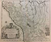
1719291534Paris 1719. Map. Engraving with original hand outline color. Image measures 19 x 23". Sheet measures 20 x 28".<br/> <br/> Unusual map of Peru from the early 18th century. Includes part of Ecuador Bolivia and Brazil based on Jesuit activity in the area. Amazon rain forest is visualized with a dynamic design. Cartouche describes the mining industry. Nicolas de Fer 1646-1720 was a prolific cartographer engraver and publisher who took over the family map business from his mother when she retired in 1687. The business flourished and he gained a great reputation in his lifetime and was appointed 'Geographer to the King' in 1690. This map demonstrates his skill and provides a curious yet alluring mixture of history and geography.<br/> <br/> unknown
1760M5799Paris: Desnos 1760. Very Good. Notes: French map of Poland Lithuania and the surrounding region.<br>1760 edition of rare Nicolas De Fer's map. Size : 480x590 mm 18.875x23.25 Inches Coloring: Hand Colored in Outline Category: Maps Europe Poland Lithuania Desnos unknown
1704M10805Paris: St. Gaspar Baillieu 1704. Very Good backed on acid free tissue paper for long term preservation. Notes: Fine large scale map focused on Southern Portugal and Southern Spain. The map is surrounded by inset maps of Olivenca Castello Ferreire Aronches Badaioz Lisbonne Setubal Chateau St. Iulien Evora.<br> Size : 561x940 mm 22.09x37.01 Inches Coloring: Original Hand Coloring Category: Maps Europe Spain; Maps Europe Portugal; St. Gaspar Baillieu unknown
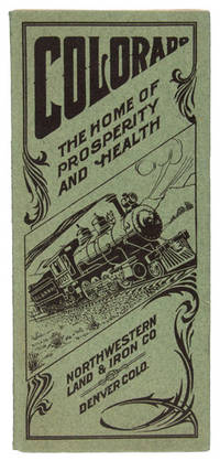
190948065N. P. Denver: Privately printed for The Northwestern Land & Iron Company n. d. ca 1909. 1909. First edition. First edition. 8vo. 9" x 8" pictorial sheet folds to 9" x 4" 16 pp. illustrated from photographs map town plat. In this booklet you are told of the commercial importance and residential desirability of MILLIKEN; THE TOWN BEAUTIFUL In Weld County Colorado and of the marvelously productive irrigated section of which it is the center and which has made Colorado famous the world over for its products of field and orchard. This is a promotional pamphlet for the town of Milliken Colorado. The folded pamphlet touches on several aspects of the town such as her educational and agricultural potential. She is touted as being a part of the irrigated district of Northern Colorado making it ideal for farming creating a homestead. Milliken is praised for her soil conditions abundance of water and a desirable truck farming district among many other topics. Also noted is her proximity to major public educational institutions making it a wonderful locality to further one’s prospects. There is a place for postage and an address on the rear wrapper as well as a perforated sheet still attached meant for inquiries about the land advertised. The railway is aggressively promoting land along their railway line for settlement. First two pages have a tiny clip to the top corners tiny tear to the fore-edge margin of page 5 else a very good copy of an attractive Colorado land promotional booklet. Privately printed for The Northwestern Land & Iron Company, n. d. (ca 1909). unknown
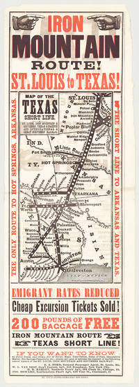
5718St. Louis: St. Louis Globe-Democrat Job Print; Woodward Tiernan & Hale Map Engr's 1878. Broadsheet with map 20.75" x 6.5" plus margins printed in black and red. Map size 11" x 5". Faded purple stamp of agent Henry H. Hannan. CONDITION: Very good upper-half of right margin rough cut. <p>A scarce and attractive promotional broadsheet with map issued by the St. Louis Iron Mountain & Southern Railway advertising special railway offers to emigrants headed to Texas.</p> <p>This broadsheet announces cheap excursion tickets free baggage up to 200 lbs. and reduced emigrant rates for departures from St. Louis on the Short Line Route which runs through Arkansas into Texas. A table of rates on the verso lists first class and emigrant rates. The Texas Short Line extends from St. Louis Missouri to Galveston and Austin and cuts diagonally across the map with various spurs along the way including intersections the Texas & Pacific R'y and the International & Great Northern R'y. Interested parties seeking assistance information on Texas maps time-tables rates of fare etc. are encouraged to call upon or address the nearest of the railroad's Agents located in Missouri Chicago New York City and Ohio whose names are provided on both recto and verso.</p> <p>The St. Louis Iron Mountain & Southern Railway began selling off land holdings in Arkansas in the mid-1870s and continued to do so into the early twentieth century. OCLC records some twenty maps published by the railroad company promoting land it owned in Arkansas issued during this time period. These lands extended from the northernmost point of the state around Little Rock to the line's southern terminus in Texarkana. The company offered various inducements for settlers deep discounts for putting money down as well as reduced freight should homesteaders wish to transport their belongings via the railway. As demonstrated by the present broadsheet the railroad also capitalized on emigration to Texas.</p> <p>OCLC records only three copies at Yale Princeton and University of Texas at Arlington.</p> St. Louis: St. Louis Globe-Democrat Job Print; Woodward, Tiernan & Hale, Map Engr's, 1878 unknown
20132081502111904015Peking University Medical Press 2013. Soft Cover. Fine. The book is in fine condition. Peking University Medical Press paperback
2091502135300807Not Available N.A. Soft Cover. Fine. Number of books: 1 Not Available paperback
2008__0415440661Taylor & Francis 2008. Hardcover. New. 1958 pages. 9.75x7.50x4.50 inches. Taylor & Francis hardcover
16-3950Paris: chez l'Auteur dans l'Isle du Palais sur le Quay de l'Orloge a la Sphere Royal avec privilege du Roy 1710. Original handcolored engraved map. 74 x 54 cm. sheet size. On old laid paper with windmill in a necklace watermark.From; Atlas ou Recueil de Cartes Geographiques Dressees Sur les Nouvelles Observations de Mrs. de L'Academie Royale des Sciences Par N. de Fer Geographe de sa Majeste Catolique et de Monseigneur le Dauphin. A Paris chez l'Auteur dans l'Isle du Palais sur le Quay de l'Orloge a la Sphere Royal avec privilege du Roy 1709.Pastoureau describes this large atlas as De Fer's folio atlas. It is described by De Fer in his catalog of 1716 as his highly detailed atlas showing all parts of the world with all the maps available separately. Paris: chez l'Auteur dans l'Isle du Palais sur le Quay de l'Orloge a la Sphere Royal, avec privilege du Roy, 1710 unknown
1706M6655Paris c. 1706. Very Good;. Notes: Cartouche in upper right corner depicts the shield of the Royal coat of arms of the United Kingdom three hunting dogs and a cockfight. The cartouche in the upper left defines the geographical coordinates of London Edinburgh Dublin and Dunkirk. Size : 460x486 mm 18.11x19.13 Inches Coloring: Original Outline Coloring Category: Maps Europe United Kingdom; Maps Europe Ireland; unknown
20061-097069704XPrivateer Pr 2006. Hardcover. New. 4 pages. 11.50x8.50x1.25 inches. Privateer Pr hardcover