2 067 résultats
170123030Paris: Nicolas De Fer 1701. First Edition. Very Good. Ginville Vincent de. Ginville Vincent de. First Edition. Paper size 42.5 cm x 28.5 cm. Plate mark 34 x 22.5 cm. Marginal paper clip stain inked '109' upper right corner some marginal chipping to the paper and old penciled price lower right. A few unobtrusive spots inside the plate marks. Copperplate engraving by Vincent de Ginville with later awfully bright hand color. This map would frame up nicely. There appears to be several versions of this map. The David Rumsey Collection has an example dated on the cartouch 1705 which he notes as being from Nicolas De Fer's Atlas Curieux published later. <br /> <br /> The Library of Congress has an example of the map offered here with the 1701 date and a separate page with explanations of the map. We don't know where this 1701 example came from separately issued or another atlas. The map highlights locations of Indian villages found by La Salle during his explorations of the coastal areas of the United States. We see the Gulf of Mexico Cap de la Floride and many inland village names. A nice map showing some early history of the southern United States. It includes parts of modern-day Louisiana Mississippi Alabama and Florida as well as the Bahamas and Cuba. Nicolas De Fer unknown
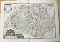
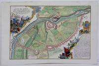
1764M10199Paris c. 1764. Very Good. Notes: An important and decorative map of Switzerland published in mid 18th century. The map originally was drawn by De Fer and later updated and improved by Desnos. Size : 485x670 mm 19.09x26.38 Inches Coloring: Hand Colored Category: Maps Europe Switzerland; unknown
2011x-9401080356Springer 2011. Paperback. New. 644 pages. 9.25x6.10x1.46 inches. Springer paperback
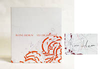
2013025242Hauser & Wirth and Xavier Hufkens Galleries in association with JRP/Ringier 2013. Book. Fine. Hardcover. Signed by the Artist. 1st Edition. 324 pages with 153 illustrations in color. SIGNED Signed on the illustrated endpaper in graphite by the artist. There are no other internal markings the binding is tight and solid the edges and corners of the boards are sharp and jacket is bright and unblemished. Edited by Michaela Unterdörfer. List of Illustrated Works. Hauser & Wirth and Xavier Hufkens Galleries, in association with JRP/Ringier Hardcover
16-5006Paris: Galerie Raymond Cordier 1962. 70x45 cm. Folded since 1962. One small hole along a fold. . Rare affiche des expositions et manifestations organisées par Raymond Cordier et Jean-Jacques Lebel du 27 novembre au 12 décembre 1962 " pour conjurer l'esprit de catastrophe. "Vous eÌ‚tes cordialement inviteÌ aÌ€ assister ou aÌ€ participer au Happening auquel prendront part entre autres J. Gab.Printed by Bernard Neyrolles. Paris: Galerie Raymond Cordier, 1962 unknown
1987x-1851660577Springer 1987. Hardcover. New. 1st edition. 550 pages. 9.50x6.40x1.50 inches. Springer hardcover
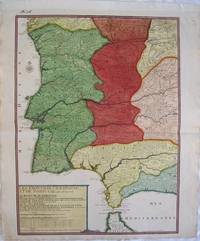
2539Europe: Paris de Fer. N 1705. Copper engraved map of Portugal and part of Spain by Nicholas de Fer from his "Atlas ou Recueil de Cartes Geographiques" Original old full wash colour; verso blank. The map shows the south western part of the Iberian peninsular: Portugal; the Algarve and parts of the kingdoms of Estramadura AndalusiaGrenada Leon and Castille extending down to the straits of Gibraltar. Good dark impression; colours bright; old ink number to upper blank margin; guard attached to upper margin; light diagonal creases towards centre fold other small printers creases/ wrinkles to centrefold; old ink title to verso. Nicholas de Fer 1646 - 1720 was the son of cartographer Antoine de Fer. Nicholas was established as an engraver cartographer and map publisher in Paris. De Fer was a prolific cartographer with over 600 maps and atlases to his credit. De Fer's work though replete with geographical errors earned a large following because of its considerable decorative appeal. In the late 17th century De Fer's fame culminated in his appointment as Geographe de le Dauphin a position that offered him unprecedented access to the most up to date new cartographic information. He would later be appointed Geographe de Roi to the kings of both France and Spain. Pastoureau FER II C 72. Europe Spain & Portugal Portugal Paris de Fer. N 1705 unknown
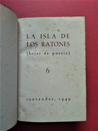
194922.1439Santander: Taller de Artes Gráficas de los Hermanos Bedia 1949 - 1952. 1ª ed. Once volúmenes encuadernados en plena piel verde. 17.5x25. Taller de Artes Gráficas de los Hermanos Bedia unknown
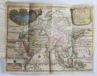
171750277Paris: Guillaume Danet Son-in law of the author 1717. Second edition. Hardcover. Good- to very good condition. Octavo. 197 9pp. 5 folding maps. Original calf with gilt lettering tooling and ruling on spine; raised bands. Decorative endpapers. Title page with copperplate engravings of two hand-colored printed globes and black double-framing California depicted as an island in this and two other maps. Second edition augmented with longitudes and latitudes of major cities. Illustrated headpiece decorative initials and endpieces. All pages with double frames; marginalia. <br /> <br /> Introduction to geography by the French cartographer and engraver Nicolas de Fer 1646–1720 containing five folding copperplate engraved maps four of them hand-colored. The first showing a general map of the globe with America in one Europe Africa and Australia in the second globe both with North and South Poles. The margins are adorned with hand-colored portraits of significant explorers; Columbus Vespuci Shouten etc. The second map is the only one in black and white. It depicts "La Sphere Artificielle." The third map shows Europe the fourth Asia the Middle-East and Oceania with parts of Europe and Africa and finally North and South America depicted on the fifth. Contains list of cities and catalog of Fer publications at rear.<br /> <br /> At the age of twelve Fer became an apprentice of the Parisian engraver Louis Spirinx. After the death of Fer's father in 1673 he also was a cartographer Nicolas took over the business specializing in the production atlases geography and cartography-oriented publications. Well connected to the Royal Court Fer advanced to become the official geographer of the Philip V of Spain and Louis XIV of France. His numerous publications are considered artistic rather than accurate.<br /> <br /> Text in French. Binding rubbed along edges and boards with front joint mostly cracked but holding together. Small plate of previous owner glued to upper inside front cover. Inked and penciled notes on verso of decorative front endpaper. Starting at title page. Some creasing and small closed tears of maps. B/w map with two inch tear reinforced with tape on verso. Map of Europe with four inch closed tear. Map of America also reinforced with three and a half inch paper strip on verso. Page ninety-three with remnants of black glossy paper glued to gutter and part of text some loss of text. Binding in overall good- interior in good to very good condition. Guillaume Danet (Son-in law of the author) hardcover
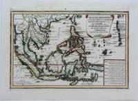
1702M5177Paris 1702. Excellent. Size : 235x340 mm 9.25x13.375 Inches Coloring: Original Outline Coloring Category: ; Maps Asia South East unknown
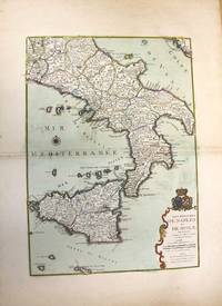
1708M10188Paris: chez Benard c.1708. Very Good. Notes: A detailed map of Southern Italy and Sicily also shows Malta. With wide margins and a pair of coats of arms is placed on top of the cartouche. Size : 560x402 mm 22.05x15.83 Inches Coloring: Original Hand Coloring Category: Maps Europe Italy; Maps Mediterranean Islands; chez Benard unknown
1401JC073<p>Nuova Raccolta Colombiana. Introduzioni note e schede di con la collaborazione di Carla Pampolini Laura Monferdini Maria Teresa di Palma. Coordinamento redazionale ed editoriale Gianni Eugenio Viola. Ministero per i Beni Culturali e Ambientali. Comitato Nazionale per le Celebrazioni del V Centenario della Scoperta dellAmerica. Istituto Poligrafico e Zecca dello Stato. Roma. 1991.</p>_x000d_<p>De 30x21 cm. com 655 págs.</p>_x000d_<p>Encadernação do editor em pergaminho rígido com ferros a ouro na lombada e nas pastas e acondicionada em caixa.</p>_x000d_<p>Profusamente ilustrado com as várias efigies de Colombo com os mapas gravuras desenhos e inscrições da época. </p>_x000d_<p>Obra impressa em papel de linho filigranado produzido especialmente para esta edição e apresentando marca-de-água com a efigie de Colombo em todos os fólios. Inclui bibliografia e índice. Obra completa pertencente à colecção editada pelo Estado Italiano com o título de Nuova Racolta Colombiana. Tiragem especial de 47/100 exemplares.</p> I-27-E-4 unknown
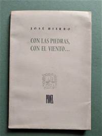
195039.184Santander: Proel 1950. 1ª ed. Rústica. 17x24.3. Retrato de Ricardo Zamorano. Dedicatoria autógrafa al poeta santanderino Ignacio Romero Raizábal con un dibujo original y fechada en 1950. Ligeras huellas de óxido en unas pocas páginas pero muy buen ejemplar. Este es el segundo libro de poesía de Hierro. Proel paperback
1996403084California 1996. Hardcover. Near Fine. A Collection of 100 used concert tickets featuring punk new wave and heavy metal bands performing in California from 1983 through 1996. The tickets vary in size from 3†x 2†to 5.25†x 2.5â€. All items are near fine with light soiling and a modest amount of creasing except for three torn tickets and 4 tickets stubs from use. The L.A. and Bay Area rock scene started in the late 1970s until new wave and heavy metal bands became the central focus of the 1980s. Some of the bands include: Mötley Crüe Iron Maiden Guns N’ Roses Depeche Mode Fatal Attraction Porno for Pyros Billy Idol Culture Club and others. The tickets span from Los Angeles to San Francisco and cities in between from 26 different venues some of which include The Troubadour Coconut Teaszer The Stone Trocadero Transfer The Metro Cow Palace The Palomino and Filthy McNasty Station. Many of the tickets are bright colors with printed pictures and stamped band logos showing the typographic designs of the time frame.<br /> <br /> Many bands kicked off their careers in California during this time. Mötley Crüe a popular heavy metal band formed in Los Angeles in 1981 is featured here playing at Oakland stadium on October 10 1987. The band is well known for their heavy make-up shocking clothing high-heeled boots and their abuse of drugs and alcohol. In 1985 the band transitioned to a more glam metal style influencing the heavy metal signature look. Guns N' Roses formed in 1985 in Los Angeles and is featured here playing at the Warfield Theatre on February 5 1988. They are a hard rock band that quickly gained popularity after the release of their debut album “Appetite for Destruction†which has sold over 28 million copies worldwide. The band has been labeled as the "the most dangerous band in the world" due to their rebelliousness and were credited to the rekindling of rock music during a time of dance music and glam metal. 1n 1992 Porno for Pyros formed in Los Angeles as an alternative rock group formed out of Jane’s Addiction. They are featured here playing at the Trocadero Transfer on June 19 1996. Their shows featured props extras and pyrotechnics. The band lasted through the mid-1990s and mixed the sounds of grunge and rock together.<br /> <br /> In the 1980s California became the melting pot of music genres mixing in punk rock new wave and metal. Certain venues became synonymous with the music genres and bands of that time. The Stone opened in the 1980s and was linked to the Keystone Berkeley and Keystone Palo Alto. It was large enough for a capacity of 700 sold only hard liquor at the bar and attracted an audience with bigger hair bigger shoes and makeup. It featured many local and big name artists in its day and was an important part of the Bay Area rock scene in the 1980s. The Coconut Teaszer operated from the 1980s through the mid-2000s. It hosted bands from all genres and featured a downstairs acoustic bar named “8121â€. Sawdust on the dance floor and giant goblets for draft beer were some of the popular trademarks of the venue. One of the notable and peculiar policies of the venue was “no open toe shoes†which was painted on the front door. The Troubadour which is still functioning today opened in 1957. New wave and punk was the main feature for The Troubadour in the late 1970s and early 1980s. Through the 1980’s the venue became synonymous with the heavy metal genre and glam bands during that time. Today The Troubadour is revered as one of Hollywood’s most respected places to see live music.<br /> <br /> <br /> An attractive collection of brightly colored concert tickets featuring popular heavy metal and punk bands from the 1980s through the mid-1990s displaying over a decade of music in California. hardcover
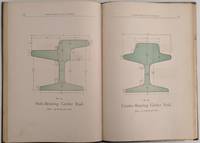
1890502San Francsico California: Pacific Rolling Mill Company 1890. 8vo. 250 x 170 mm. 10 x 7 inches. 100 pp. plus 4 leaves of ruled paper 2 with measurements in manuscript. Illustrated throughout with simple drawings of parts many stenciled with green wash; one plate folding. Bound in limp cloth covered boards title in gilt on front cover; a cloth binding shows some wear to gilt title two pencil drawings on front endpaper; other a very good sound copy. Straight forward price list of iron bar steel rail rolled and forged metal axles nuts bolts washers and dozens of other metal products. There is no introduction about the history of the firm just images of parts prices and a few lines of text describing specifications for some of the more complicated manufacture items. What distinguishes this rare trade catalogue is the design sense of many of the images and the application of stenciled color to highlight the object. The printed form of the parts are in outline and as one pages through the catalogue the images take on an abstract quality. Metal parts become contoured shapes with form being determined only by the light green wash applied to the physical part of the design. Although unintentional I am sure this late 19th century publication replete with many of the characteristics of period book design exhibits a very modernist feel one that is most unusual in publications of this nature. Although called the 7th edition this is only one of three issues of the PRMC's product guide and price list that is known. Organized in 1867 PRMC grew continuously and by 1892 was producing more than 40 thousand tons of iron and steel. "This giant enterprise is so closely identified with the manufacturing interests of the Pacific Coast that there is scarcely a manufacturing firm or corporation on the Coast that does not depend upon its output. The mills are located at Potrero Point in South San Francisco and cover an immense area" Master Hands. Romaine Guide to American Trade Catalogues p. 200 this edition and one from 1886 both known in only one copy each at California Historical Society. OCLC cites an edition from 1885 in one copy at San Francisco Public Library and this edition 1890 also in only one copy at California H. S. See: Master Hands in the Affairs of the Pacific Coast Historical Biographical and Descriptive. A Resumé of the Builders of Our Material Progress. San Francisco: Western Historical Publishing Company 1892 pp. 260. Pacific Rolling Mill Company unknown
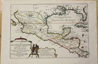
1705M772Paris 1705. Excellent. Notes: This map covers the Gulf of Mexico through Central America and includes parts of Cuba and Jamaica. It extends through Mexico to show the southern tip of Baja California. This is an early map to show the correct location of the Mississippi River delta gleaned from the expeditions of La Salle and Iberville. Two French forts are located: LaSalle's Fort St. Louis in Texas Fortbati en 1685 and another near present-day New Orleans. One of the prominent features in northern Mexico is Les Fameuses Mines de Ste. Barbe the legendary Santa Barbara mines of the Chihuahua-Durango region. Size : 230x335 mm 9x13.125 Inches Coloring: Original Outline Coloring Category: Maps Central America Mexico unknown
1705M5280Paris 1705. Excellent. Size : 225x340 mm 8.875x13.375 Inches Coloring: Hand Colored Category: ; Maps Europe Estonia Latvia unknown
AQ27281s.i. London: s.n. s.d. c. 1730 3pp 1. Docket title to verso of second leaf. Disbound with slight chipping at gutter and extremities old folds slightly browned to extremities. Wax crayon numeral and ink paginations at head. A rare example of early eighteenth-century lobbying literature composed 'four years since' ironmaster and mintmaster William Wood 1671-1730 began exploiting newly developed methods of producing 'Iron with Oar and Pitcoal in Air-Furnaces' in enormous industrial works at Whitehaven apparently composed to discourage the Government from providing funds for the building of further furnaces near Chelsea high-road. In addition to decrying the quality of the iron produced and 'several notorious Frauds practised' by Wood's operation this work warned of the danger of his somewhat novel company incorporation practices and the possibility of these resulting in 'Stock-Jobbing and the Arts of raising Bubbles'. Rare; ESTC locates a single copy BL. ESTC T20614. Folio. [s.n.], [s.d., c. 1730] unknown
mon0000685296Blurb 6/4/2019 12:00:00 AM. hardcover. Very Good. 1.3386 in x 8.1890 in x 5.2362 in. Crease on cover Blurb hardcover
183730091St. Louis 1837. 36pp folding plate frontis full-page map. Institutional rubberstamps at base of title page verso. Original printed wrappers light rubberstamp discard stamp on front wrapper. Otherwise Very Good. <br /> <br /> "Missouri Imprints Inventory No. 197 cites only one copy. This tract is probably the first description of Iron mines west of the Mississippi. The Iron Mountains were located in St. Francis and Madison Counties. A proposal is made to make iron rails for a railroad from the mountains to the Mississippi" Decker. <br /> AII MO 197 1. 37 Decker 214. Not in Eberstadt Soliday Graff. OCLC indicates a number of institutional copies. unknown
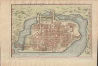
1715019811Paris. Very Good. 1715. Map. Lovely engraved map depicting Mexico City in the early 18th century. Map is on a 10 ¾" x 15 ¾" sheet that was taken from Nicolas de Fer's "L'Atlas Curieux" of 1715; no content on verso. Date of map was printed in upper margin along with the sheet number "125" and title; content in French. Hand-coloring is still bright. Map has very light toning to edges but is otherwise clean. This detailed map depicts Mexico City when it was surrounded by water and was linked to the mainland by the famous causeways originally designed by the Aztecs. Also pictured are aqueducts and farms and about 50 locations have been numbered on the map but the key is not present likely printed on another page in the Atlas. A beautiful map. . unknown
ria9789401080354_inpPaperback. New. New Book; Fast Shipping from UK; Not signed; Not First Edition; N/A paperback
ria9781851660575_inpHardcover. New. New Book; Fast Shipping from UK; Not signed; Not First Edition; N/A hardcover
19225564mInternational Casement Co. Good. Paperback. 1922. Solid and very well-preserved. Some wear along the spine crown otherwise clean <br><div class=book__description> l Casement Co Jamestown New York. Elegant October 1922 catalogue the 7th cata logue issued by International Casement Company of Jamestwon NY and featuring d . International Casement Co. paperback
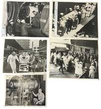
1937234531937. Iron lung transport press archive documenting the movement of respirator-dependent polio patients through rail terminals ships ramps aircraft hospitals and Coast Guard facilities during the years before the Salk vaccine changed American polio care in 1955. The iron lung developed in 1928 by Philip Drinker and Louis Agassiz Shaw kept patients breathing when polio paralyzed the muscles needed for respiration. Fred B. Snite Jr. appears in several views as the nationally followed Chicago patient who contracted polio in China in 1936 and returned to the United States after a highly publicized 9300-mile medical journey. The group is strongest as a record of medical transport itself: nurses in masks uniformed officers attendants ramps crowds and captioned press slips show how survival could depend on coordinated movement as much as bedside treatment.<br /> <br /> Photo archive of 5 large silver gelatin press photographs approx 8 x 10 inches Chicago Seattle Port Angeles and related transport locations 1937-1951. Snite's respirator is loaded at a Chicago railroad terminal with his head visible through the front window while men adjust the wheeled carriage; another scene places the iron lung at a ship or dockside ramp surrounded by masked nurses uniformed officers and hospital attendants. A Chicago caption dated February 8 1939 reads "Iron Lung Kid and Bride Entrain for South" identifying Snite and his bride leaving for Miami Florida after their winter vacation. Another verso caption dated June 22 1937 describes his return to Chicago after transport from China where he had been stricken. A January 14 1951 Coast Guard caption identifies an iron lung flown from Seattle to Port Angeles to aid Eldon Tetum a 36-year-old logger stricken with polio.<br /> <br /> Polio epidemics made the iron lung one of the most visible medical machines of the mid-twentieth century especially before vaccination reduced annual cases after 1955. These scenes connect celebrity medical news to emergency public health logistics showing how mechanical respiration required attendants vehicles terminals aircraft and institutional coordination outside the hospital room. Press stamps pasted captions adhesive staining and surface marks visible on versos; images remain strong and readable. Overall in good condition. unknown