8 447 résultats
1889286066Kendal: printed by T. Wilson / Stafford: Allison & Bowen 1889. First Edition. Softcover. Good copy in original stiff card wrappers with some wear and tear as with age. Remains well-preserved overall; bright and clean. Physical description; two pamphlets in one. Subjects; Society Transactions. Cumberland. Westmorland. North Staffordshire. Field Club. Antiquarian Society. Archaeological Society. Kendal: printed by T. Wilson / Stafford: Allison & Bowen paperback
1809984F6Edinburgh; London: Bell & Bradfute; A. Constable; T. Cadell and W. Davies 1809. First edition. Paperback. Very Good. 11.5" by 9.5". Not Stated. The first edition of Volume VI Part II of this impressive early 19th century scientific and mathematical journal with articles on a range of subjects from zoology to geology. First appearing in 1788 the journal Transactions of the Royal Society of Edinburgh saw the first publication of countless important works of scientific research and studies in humanities social sciences and history.Present here is first edition of Volume VI Part II 1809 this volume includes a history of the society alongside articled including 'Chemical Analysis of Sodalite' by Thomas Thomson 'The Large Snake Alea-azagur' by James Russell 'Remarks on a Mineral from Greenland' by Thomas Allan 'Chemical Analysis of Black Sand' by Thomas Thomson and 'The Quadrature of the Conic Sections' by William Wallace.Illustrated with four folding plates plates IX-XII. Collated lacking three additional plates that are not present. In the publisher's original paper wraps with paper label to back strip. Externally excellent. Internally firmly bound. Title page lightly age toned to head with spotting. Pages otherwise bright with the odd spot. Gatherings unopened to heads. Lacking three folding plates. Very Good Bell & Bradfute; A. Constable; T. Cadell and W. Davies paperback
181744518Paris Courcier 1817. Contemp. hcalf. Richly gilt spine. Tome-and titlelabels with gilt lettering. An old repair to spine at upper compartment. Some small cracks to leather at spine. Spine a bit rubbed. XVIXXII253 pp. and 3 large folded engraved plates with many figs. showing crystal forms and Nicholson's hydrometer. Some scattered brownspots mainly at margins. A wide-margined copy. <br/><br/><em>Scarce first edition of Haüys landmark work on the crystallography of gemstones. Haüy had already in 1784 demonstrated the constancy of aspects of the geometric form of the individual crystals and hereby he laid the foundation stones of the science of Crystallography in general. In the offered work he applies his crystal-discoveries of the constancy of angles to the cutting of gems thus providing us with the first handbook to show how to determine different kinds of gemstones and he thereby also founded the science of Gemology. "He hypothesized that each crystal was built up of successive additions of what we now call a "unit cell" to form - in the absence of external inteference - a simple geometric shape with constant angles and with sides trhat could be related by simple integral ratios. he maintained that an identity of difference in crystalline form implied an identity or difference in chemical composition. This was the beginning of the science of crystallograpy which was to attain maturity over a century later with the development of X-ray techniques by Laue and Bragg."Asimov. </em> hardcover
180551116Paris Courcier 1805. 4to. Contemp. Full calf. Gilt spine. Titlelabel with gilt lettering. A paperlabel pasted on top of spine. Stamps on title-page.Corners a bit bumped. Spine slightly rubbed. XXIV318 4 Errata pp. 16 Tables and 10 large folded engraved plates apparatus. Wide-margined and clean. <br/><br/><em>First edition. Pouissant is best remembered for his invention of a new map projection for a new map of France and he was involved in the production of the map. The map was produced with considerable detail the projection used spherical trigonometry truncated power series and differential geometry as described here. </em> unknown
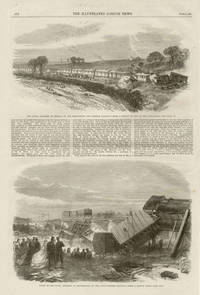
186524211865. Wood-engraving. 405mm by 275mm sheet. Top image titled - 'The Fatal Accident at Rednal on the Shrewsbury and Chester Railway'<br /> Lower image titled - 'Scene of the Fatal Accident at Staplehurst on the South-Eastern Railway'Charles Dickens was a survivor of the Staplehurst crash.Related and unrelated text on the reverse. unknown
1860mon0000052523John W Parker 1860-01-01. Hardcover. Good. in x in x in. Ex-library book usual markings. Hardback rebound by library. Clean text sound binding. John W Parker hardcover
180112760Leeds: printed by Thomas Wright January 18 1801. 11.9 x 7.6 cm. Printed on one side only with a border of small printer’s flowers. Bit darkened at edges with a little spotting on the bottom left corner.R. Spencer & Sons were a chemist and alcohol merchants in Leeds who imported good Brandy and rum from the Caribbean as well as Gin and what they called British wines viz. madeira malaga mountain calcavella orange cowslip &c “which from Age and Quality are little inferior to Foreign Wines of nearly double the price.<br>The card refers to a “present scarcity of corn†and advertise “pectoral and cordial balls for racers hunters and horses of every descriptionâ€. printed by Thomas Wright unknown
18158986740F. C. and J. Rivington 1815. This is an ex-library book and may have the usual library/used-book markings inside.This book has hardback covers. Contains pencil markings. In poor condition suitable as a reading copy. Re-bound by library. Size: Octavo. Binding: Rebound. Frontispiece map. Map is slightly torn at the edge but not onto the actual image. Front page has damage repaired by tape. Heavy foxing. Pages are yellowing. Please note the Image in this listing is a stock photo and may not match the covers of the actual item600grams ISBN: F. C. and J. Rivington hardcover
18151086E152London: F.C. & J. Rivington 1815. 2nd Edition . Hardback. Printed pages: viii 326 Fold-out hand coloured map 'Christianography or Map of Christendom at the end of the Fifteenth Century'. Very Good Plus. 5.75 x 9.25 inches 14.5 x 23.5 cm. Later quarter cloth with original paper covered boards. Paper title label to spine light marking to boards engraved bookplate and private library label inside front board. Fold-out map is in excellent condition with no creasing or tears and no marks or foxing. Good solid binding. Page edges untrimmed. Occasional light foxing to text but pages are generally very clean throughout. A very scarce collection of tracts denouncing the claims of the Roman Catholic church. Complete with the hand coloured fold-out map. Overall condition is Very Good Plus. Size: 5.75 x 9.25 inches 14.5 x 23.5 cm. F.C. & J. Rivington hardcover
184074678London and Oxford: J.G.F. & J. Rivington & J.H. Parker 1840. Boards sunned along edges and to spine rubbed light wear to corners and spine ends small ink inscription to front pastedown light foxing to endpapers light spotting to fly-title page contents clean and tidy binding sound. Cloth Covered Boards. Good. 8vo. J.G.F. & J. Rivington & J.H. Parker Hardcover
1840213329New York: Charles Henry 1840. Hardcover. Good. Good Hinges cracked but binding still fairly tight cloth on spine ends and panel corners torn panels and spine soiled and worn panel corners bumped brown spotting on pages various pages show outer edge roughly cut former owners name in ink on front end page Volume 3 only. Charles Henry hardcover
1839201410New York: Charles Henry 1839. Hardcover. Good. Second edition. Good hardcover. 2nd US edition. Volume one only. Former owner's name on front endpaper. Light brown spots inside covers and on endpapers and outer edges of pages. Cover panels coming off the hinges. Spine completely missing. Corners on cover rubbed and bent. Charles Henry hardcover
1840213148New York: Charles Henry 1840. Hardcover. Good. Volume 2. Good Cloth on panels and spine rubbed and soiled panel corners and spine ends bumped and rubbed top of spine shows cloth torn about 1/2in on each side of top of spine some slight tearing on bottom spine end pages show brown spotting former owners name in pen on front end page Volume 2 only. Charles Henry hardcover
184040777London: J.G.F & J Rivington 1840. spine and back cover have considerable sunning inscrip to p/d light foxing to closed edges and rear end papers pp clean and tidy. Leather Boards. Good Minus/No Jacket. 8vo. J.G.F & J Rivington Hardcover
189937660London: Duckworth and Co. As New. 1899. Hardcover. FREE UPGRADE to Courier/Priority Shipping Upon Request IN STOCK AND IMMEDIATELY AVAILABLE FOR SHIPMENT - -- with a bonus offer-- . Duckworth and Co. hardcover
189677014Washington DC: U.S. Department of the Navy Bureau of Navigation Hydrographic Office 1896. Presumed First Edition First printing thus. Map. Good. This was published at the Hydrographic Office in Washington D.C. in February 1896. No. 1530. Charles D. Sigabee Commander U.S. N. Hydrographer. Format is approximately 26 inches by 17 inches folded. This map is disbound from Volume I of the Commercial Directory of the American Republics compiled by the Bureau of American Republics International Union of American Republics Joseph P. Smith Director 1897 Title page from Directory is present. Taped to top right of map in margin is the statement "This chart is intended solely to show tracks of steam vessels on the ocean and no authority is assumed for the boundary lines as drawn between the countries." Map has some color differentiation and several inserts presenting distance information between major ports of call. Map has been folded with approximately the top third folded down. It is also folded into four sections of different lengths to fit as the frontis to the Directory. Map has some wear and soiling/staining. This is similar to the large-scale and detailed World chart on Mercator's projection produced by the British Admiralty under the "Superintendence of Captain Wharton R.N. F.R.S Hydrographer" engraved by Edward Weller and sold by J. D. Potter chart agent. The map has no internal landmass detail unless relevant to steam ship routes thus the Suez and Panama canals are marked as is the Canadian Pacific Railway. Panels along the lower edge list major ports and give distances dependent on routes taken and average knots-per-hour speeds with daily distances covered in miles. The world's major ports are linked by ship-routes each track with its relevant distance and so on. An interesting chart at the time steam took over from sail. Charles Dwight Sigsbee 1845 - 1923 was a Rear Admiral in the United States Navy. In his earlier career he was a pioneering oceanographer and hydrographer. He is best remembered as the captain of the USS Maine which exploded in Havana harbor Cuba in 1898. U.S. Department of the Navy, Bureau of Navigation, Hydrographic Office unknown
1860025831London: Richard Bentley 1860. Hardcover. Good/No Jacket. 4.5" x 7. 286 pages. Accounts of social conditions in east London and south Essex. A clean and sound book in a faux-leather hard cover binding and the usual stamps and stickers from a reading room / library. Light foxing throughout. All orders processed promptly and shipped from the UK. If your shipping destination is outside the UK please order with the fast / air / expedited shipping service at checkout. 4.5"x7". <br/> <br/> Richard Bentley hardcover
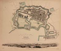
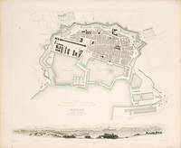
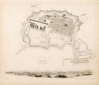
1844310653London: Charles Knight 1844. unbound. Map. Original engraving. Sheet measures 13 1/2" x 15 7/8". London: Charles Knight 1844.<br/> <br/> Incredibly detailed city plan of Toulon with a lovely panoramic view overlooking the city and harbor from the outworks on the east. Canals and ports surrounding the fortified city are hand colored. Streets buildings bridges plazas churches gardens and other points of interest are labeled. In the illustrated view principal buildings are indicated. Drawn by W.B. Clarke and engraved by B.R Davies. In excellent condition.<br> <br> The Society for the Diffusion of Useful Knowledge or SDUK was formed in 1826 and published low cost maps with the goal of reaching a large market while still maintaining high quality and precision.<br/> <br/> Charles Knight unknown
184766542London. 1847. This is a pleasant town plan of the important French Naval port of Toulon on the Mediterreanean coast. Along the base of the map is a delightful panoramic view taken from the east. Published by Charles Knight for the S.D.U.K. Size: 355 x 430 mm. Steel engraving with original outline colour. Good condition. unknown
183765520London. c.1837. This is a pleasant town plan of the important French Naval port of Toulon on the Mediterreanean coast. Along the base of the map is a delightful panoramic view taken from the east. Size: 340 x 410 mm. Steel engraving. Good condition. Some age toning. unknown
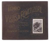
18996800London: Church Missionary Society. Good with no dust jacket. 1899. First Edition. Hardcover. Owner's inscription on front pastedown. Fading to front board. Some rubbing to ends of spine. 1/4" tear to paper at head of spine. 2" split at head of front spine joint. 3/8" x 1/8" loss of paper at tail of spine. ; i 51 pages. Black papered boards with gilt illustration. Gilt page edges. Illustrated. Page Dimensions: Oblong 220mm x 188mm. List of Illustrations: A Muganda Porter; The Mission Station Toro; A Storm: Bethlehem Mission Station Toro; On The Way To Toro; The Ruwenzori From Semliki Valley; Ruwenzori Toro; Waganda Soldiers; The Rev. T. R. Buckley And The Katikiro of Toro; Threshing Beans: A Village Of The Bakonja Ruwenzori; A Crater Lake Toro; The Albert Edward Nyanza; The Boiling Springs At The Foot Of Mount Ruwenzori Semliki Valley; Crossing The Semliki River.; 8vo . Church Missionary Society hardcover
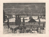
187527051875. Wood-engraving. 165mm by 225mm image. Half-page illustration from 'The Australasian Sketcher'. Unrelated text on the reverse.<br /> unknown
1891022669Boston: Appalachian Mountain Club 1891. No Binding. Near Fine. An original heliotype map published by the AMC Appalachian Mountain Club in January 1891. Folded twice each way as published. 21" x 24". Archival tape on the verso some minor loss at a few fold junctions. Good Scarce. <br/> <br/> Appalachian Mountain Club unknown
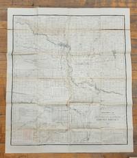
18981550351898. Fair. Part of the Annual Report of the Department of the Interior for 1899. From Surveys by R. W. Macintyre C.E. 103x89 cm unfolded. Partial colour. Shows Sarcee Indian Reserve Calgary Okotoks Red Lake High River. Folds to fit into 19x24 cm brown envelope with tears chips and soiling. Map itself has holes and tears in the folds. Fragile. <br/><br/> unknown