Ortelius, AbrahamBiblio.com
213 résultats
159813293451598. A map of the Holy Land by Abraham Ortelius dated 1598 first issued in 1584 as a part of Theatrum Orbit Terrarium. In Very Good condition with age toning and a central crease. Matted but not framed. w 26.5 in. x h 22 in. Shelved at Rockville PS 1101 #25. Based on material collected by the Dutch Astronomer Peter Laicksteen who travelled to the Holy Land in 1556. Christian Sgrooten here written "Schrot" royal geographer to King Phillip II of Spain produced a nine-sheet map of Palestine in 1570 from Laikstain's information. This map was condensed into the present form by Abraham Ortelius. Ortelius the creator of the first modern atlas collected and edited maps from all over Europe for his book. Many of the original mapmakers rose to fame solely through Ortelius's decision to include their maps in his atlas. Laicksteen took thorough and accurate notes and the original Laicksteen and Sgrooten map contained improvements over earlier maps. For instance the River Kishon is here shown as flowing from the mountains near the Sea of Galilee not as was previously thought from the Sea of Galilee itself. However the Levantine coastline Sgrooten and Ortelius depicted is hardly recognizable to modern eyes. The map is replete with fanciful bays and peninsulas though some of the most recognizable features of the coastline such as the outcrops of land at Haifa and Beirut are absent. Ortelius had originally used another map of the Holy Land by cartographer Tilleman Stella in the early editions of the Theatrum Orbis Terrarum. It covered a far more extensive territory including part of Egypt and Syria. Oddly the coastline in this first map was much more accurate than in the Sgrooten map. Laicksteen and Sgrooten's original map included a small inset with an extended geography. However their mapping of the Dead Sea and surrounding areas was so controversial that Ortelius chose to leave out this region completely. The strange anecdote written in the Dead Sea is Ortelius's own addition. It describes how the Dead Sea was once a fertile valley but was transformed by an act of God into a barren sea to punish the wickedness of Sodom and Gomorrah. In the bottom left hand corner is a hand colored illustration of the story of Jonah. Above the luscious cartouche Ortelius has added three miniatures featuring the Crucifixion the Nativity and the Resurrection of Christ. The French text on the verso a long-winded description with little relevance to the map was changed to a more "reader-friendly" version shortly after the publication of this edition. 525 copies were made of this edition of Ortelius's map. 1329345. Special Collections - Upstairs. unknown
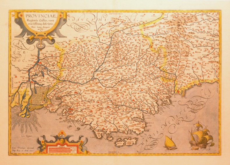
159854753Antwerp. 1598. This glorious map is embellished with an elegant border and a bold imposing title cartouche in top right corner and a smaller oval cartouche in bottom left corner containing nine lines of Latin text. Natural topography is clearly delineated with the relief shown pictorially. Charming details include a couple of sailing ships a large flying fish and two warriors in their tented camps. This beautiful and important map still showing California as a peninsula was much copied by other cartographers. Size: 470 x 350 mm. Copper engraving. Original colour. Fine condition. Moreland & Bannister Antique Maps p.269. unknown
15782206Antwerp: Plantin 1578. Hardcover. Very Good. 4to - over 9¾ - 12" tall. 4to. 23 x 16.5 cm 4 ff. 417 1 pp. 1 f. Bound in contemporary vellum over flexible boards head slightly chipped; early signature on t-p. Woodcut 'golden compass' device of the Plantin press on title. Generally good. First edition of this early modern geographical dictionary published alongside the first Plantin edition of Ortelius' successful Theatrum orbis terrarum Antwerp 1579 and listing thousands of names both ancient and modern for "peoples regions islands great and small towns mountains foothills forests seas bays lakes" etc. depicted in the atlas. Earlier versions of the Synonymia had previously appeared as indices to the atlas containing a little over 2000 entries; "in all this first version of Ortelius' geographical dictionary in the form of a separate book includes approximately 10000 entries" Meurer. Ortelius' methodology in the present volume differs from that of his earlier indices: a parallel glossary of non-Latin names has been turned into a bilingual appendix and Ortelius relies almost completely on classical authors quoting moderns only when he cannot go straight to the source. The significance of these alterations for the author's role not as mapmaker but as linguist and lexicographer is hard to overstate: his introduction declares that he undertook the new Synonymia largely out of frustration at the scholarly inadequacy of current Latin lexica including earlier editions of his own which frequently printed inexact or even nonexistent terms sometimes on dodgy authority. Voet 1835; Skelton Theatrum orbis terrarum facsimile 1964; Meurer in Abraham Ortelius and the First Atlas ed. Voet pp. 331-346. Plantin hardcover books
15782206Antwerp: Plantin 1578. Hardcover. Very Good. 4to - over 9¾ - 12" tall. 4to. 23 x 16.5 cm 4 ff. 417 1 pp. 1 f. Bound in contemporary vellum over flexible boards head slightly chipped; early signature on t-p. Woodcut 'golden compass' device of the Plantin press on title. Generally good. First edition of this early modern geographical dictionary published alongside the first Plantin edition of Ortelius' successful Theatrum orbis terrarum Antwerp 1579 and listing thousands of names both ancient and modern for "peoples regions islands great and small towns mountains foothills forests seas bays lakes" etc. depicted in the atlas. Earlier versions of the Synonymia had previously appeared as indices to the atlas containing a little over 2000 entries; "in all this first version of Ortelius' geographical dictionary in the form of a separate book includes approximately 10000 entries" Meurer. Ortelius' methodology in the present volume differs from that of his earlier indices: a parallel glossary of non-Latin names has been turned into a bilingual appendix and Ortelius relies almost completely on classical authors quoting moderns only when he cannot go straight to the source. The significance of these alterations for the author's role not as mapmaker but as linguist and lexicographer is hard to overstate: his introduction declares that he undertook the new Synonymia largely out of frustration at the scholarly inadequacy of current Latin lexica including earlier editions of his own which frequently printed inexact or even nonexistent terms sometimes on dodgy authority. Voet 1835; Skelton Theatrum orbis terrarum facsimile 1964; Meurer in Abraham Ortelius and the First Atlas ed. Voet pp. 331-346. Plantin hardcover
1598LBW-1391Anvers 1598 81 x 106 mm.
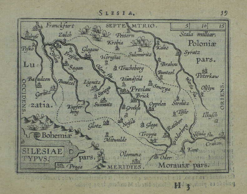
15793004<p>Paper size: 392 x 500 mm. Plate size: 278 x 386 mm. 16th century map in original hand-coloring. Depicts rivers forests ranges monasteries and towns/cities including Prague and Frankfurt. Latin text regarding Silesia to verso. Please see image. Ortelius 102. ; 392 x 500 mm ; All shipments through USPS insured Priority Mail.</p> Abraham Ortelius
157426946Antwerpen: Platin 1574. Other. A strong impression. In excellent condition. 280 by 385mm 11 by 15¼ inches. Copper engraving uncolored as published. Latin text edition printed 1574. Broe. 102. Platin unknown
158715883Antwerp 1587. Three part old color map of Italy showing Corsica Siena and Ancona. With an Ortelius watermark on the section with Corsica. According to Dr. Marcel van den Broecke it is based on "an anonymous 'Marca Anconitana' published in 1564 by Vincenzo Luchini Meurer p. 95. On the authority of Brandmair 1914 p. 71 Karrow attributes this map to Cæsar Orlandi see Hessels nr. 39". Ornate cartouche in the map of Siena with a text block about the bountiful supply of fish. French text on verso. This map corresponds to Dr. Marcel van den Broecke and Dr. Deborah van den Broecke-Günzburger's Ort 137 classification: "Occurrence in Theatrum editions and page number: 1587F74 250 copies printed last line left aligned: se sous le Pape. A la fin elle est retournée en la puissance des Geneuoisausquels elle obeit encore. Image size: 19 x 13". Paper size: 23 1/8 x 17 1/2". Very good. unknown
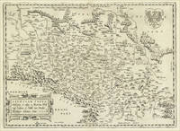
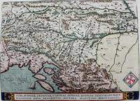
1595M7934Antwerp Belgium c.1595. Very Good;. Notes: French text on verso. Size : 336x463 mm 13.23x18.23 Inches Coloring: Hand Colored Reference: Marcel P.R. van den Broecke 145. Category: Maps Europe Balkans; unknown
15958231Antwerp Plantin-Moretus 1595. Copper engraving 33 x 46 cms modern hand-colour Latin text on verso. Ortelius map of the western Balkans drew on the cartography of Augustin Hirschvogel. Van den Broecke 145.3 Map unknown
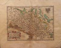
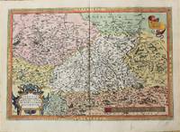
1571M10736Antwerp 1571. Very Good. Notes: Dutch text on verso. <br>16th century map of Germany by Abraham Ortelius published in his atlas; Theatrum Orbis Terrarum. Size : 342x508 mm 13.46x20.00 Inches Coloring: Hand Colored Reference: Marcel P. R. van den Broecke #93. Category: Maps Europe Germany; unknown
158437541Antwerpen 1584. In excellent condition. . 345 by 503mm 13 by 19 inches. Hand-Colored Original Copperplate Engraving by Abraham Ortelius depicting Saxoniae Misniae Thuringiae Nova Exactissimaq Descriptio. Published Antwerpen 1584. Sheet: 345 by 503mm 13 by 19 inches. A fine and original hand-colored example of Ortelius's celebrated cartographic work documenting this region of Germany with the precision and decorative artistry characteristic of the 15800s. Abraham Ortelius 1527-1598 was a Flemish cartographer and geographer from Antwerp widely regarded as the creator of the first modern atlas. His landmark publication Theatrum Orbis Terrarum 1570 set the standard for atlas-making for the next century presenting uniform copper-engraved maps with scholarly commentary. By Ortelius's death the Theatrum had appeared in 25 editions in seven languages. In 1575 King Philip II of Spain appointed him Royal Geographer. His maps engraved with extraordinary precision are among the most sought-after in antique cartography held in collections including the Plantin-Moretus Museum in Antwerp the Library of Congress and the British Library.This original copperplate engraving with original hand coloring depicts the region of Saxoniae Misniae Thuringiae Nova Exactissimaq Descriptio. published in Antwerpen 1584. The map records the political and geographic boundaries of the region as understood in 1584 offering a fascinating window into the history of German territorial organization. Sheet measures 345 by 503mm 13 by 19 inches. In good condition overall with minor signs of age appropriate for a 16th-century engraving. Ready to frame. Broe. 93 unknown
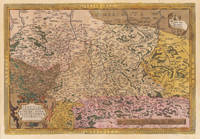
158552380Antwerp. c.1585. Very attractive map with ornamented cartouche and border.Three scales. The map was criticised by Hiob van Magdeburg at an early stage but survived through all editions of the Ortelius's landmark atlas. Published in the landmark work by Abraham Ortelius The Theatrum Orbis Terrarum. Copper engraving. The map itself is in good condition.V shaped water mark at top centre fold affecting margin and extending 25 mm. on to map tiny hole at top edge of centre fold. Expert repairs near invisible from the front on left hand margin and lower left hand corner faint watermarks on lower edge. Original colour. Size: 50 x 34 cm. van den Broecke 93. unknown
159552816Theatrum Orbis Terrarum. 1595. Ortelius based the map on the map and plan by Marcus Secsnagel 1551. Braun and Hogenberg also used Secsnagel work. The poem at the top left commemorates him. The map has been drawn as if stretched over a frame with the edges pinned down the lower edges have rolled free to reveal the town plan at lower right Copper engraving. Fine condition good margins top edge very slightly worn Later colouring. Size: 43 x 34 cm. 17 x 13½ inches van den Broecke 107 unknown
15842100981584. Auf Bütten mit Wasserzeichen "Wappen". 35 x 19,7 cm (Plattengröße) 43,5 x 26 cm (Papier).
15842101091584. Auf Bütten mit Wasserzeichen "Zwei gekreuzte Pfeile". 35 x 19,7 cm (Plattengröße) 43,5 x 26 cm (Papier).
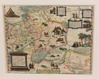
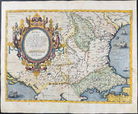
1574M10843Antwerp Belgium c.1574. Very Good. Notes: Latin text on verso. L.61<br>Decorative map of Russia by Abraham Ortelius. Size : 352x448 mm 13.86x17.64 Inches Coloring: Original Hand Coloring Reference: Marcel P. R. van den Broecke #162. Category: Maps Russia; unknown
1598LBW-1431[Anvers, 1598]. 80 x 106 mm.
15849713<p>Original hand-colored engraving from Abraham Ortelius's <em>Theatrum Orbis Terrarum - Parergon - Nomenclator Ptolemaicus. </em>Features Latin text to verso see image and a large attractive cartouche. The map includes firing vessels a sea monster as well as birds & insects sitting on the cartouche. The image measures approximately 19.5 x 14.25 in 49.5 x 36 cm; page measures 21 x 17.25 in 53.5 x 44 cm.</p> Christoph Plantin Press
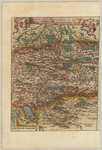
157432793Antwerp: Platin 1574. Other. In excellent condition.which was then in theHabsburg Netherlandsmodern-day Belgium. 340 by 260mm 13½ by 10¼ inches. Original antique copper engraving hand colored in outline and wash when published. Latin text edition. "Tirolis Comitatus" a fine engraved map depicting of the county of Tirol after Wolfgang Lazius published in a 1574 Latin text edition of the "Theatrum Orbis Terrarum" by Abraham Ortelius. Abraham Ortelius published this map between 1573 until 1612 in various editions of his atlas "Theatrum Orbis Terrarum". From this 1574 Latin text edition only 175 copies were published! A fine a decorative 16th century map of Tirol. With many engraved details as some place names rivers mountains lakes small villages and cities. Place names are still engraved as miniature views. At the bottom the "privilegium" and a dedication to Wolfgang Lazius. Ortelius was born on 14 April 1527 in the city of Antwerp which was then in the Habsburg Netherlands modern-day Belgium. The Orthellius family were originally from Augsburg a Free imperial city of the Holy Roman Empire. In 1535 the family had fallen under suspicion of Protestantism. Following the death of Ortelius's father his uncle Jacobus van Meteren returned from religious exile in England to take care of Ortelius. Abraham remained close to his cousin Emanuel van Meteren who would later moved to London. In 1575 he was appointed geographer to the king of Spain Philip II on the recommendation of Arias Montanus who vouched for his orthodoxy. He travelled extensively in Europe and is specifically known to have traveled throughout the Seventeen Provinces; in southern western northern and eastern Germany e.g. 1560 15751576; France 15591560; England and Ireland 1576; and Italy 1578 and perhaps twice or thrice between 1550 and 1558. Beginning as a map-engraver in 1547 he entered the Antwerp Guild of Saint Luke as an illuminator of maps. He supplemented his income trading in books prints and maps and his journeys included yearly visits to the Frankfurt book and print fair where he met Gerardus Mercator in 1554. In 1560 however when travelling with Mercator to Trier Lorraine and Poitiers he seems to have been attracted largely by Mercator's influence towards the career of a scientific geographer. Wikipedia Bibliography: Broe. 116a K/M:62a K:1/89 Platin unknown
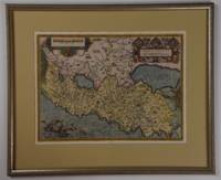
1570214216Antwerp: Ortelius Abraham 1570. unbound. very good. Map. Uncolored engraving. Image measures 14 3/8" x 19.75".<br/><br/> Beautiful map of southern Italy. Latin text on verso. Published in "Theatrum Orbis Terrarum". Minor scattered staining particularly in margins. Full original margins.<br/><br/> Ortelius, Abraham unknown books
1592200015AG1592. Antwerp Ortelius c.1592. Original hand-coloured engraving. Plate Size: 49.6 cm x 37.6 cm. Sheet Size: 57.8 cm x 45.6 cm. Original map. Very good condition. Clean and crisp impression. Some slight creases along edges. Very minor barely visible tears to lower edges. Hernando Abb. S. 139; Imagens 11; Broecke 25.3; Koeman III 6000:31/b. - 3. Zustand from 4 with "Estrecho de Gibraltar". Border with longitudinal and latitudinal information. A beautifully detailed map of the Kingdom of Spain with the smaller provincial and historical kingdoms - Galitia Asturias Biscaia Navarra Aragonia Catalonia Castilia Nova and Vetus Valencia Murcia Granada and Andaluzia - also delineated as is Portugal. The Balearic Islands are also included. In the top right corner the French cities of Montpellier and Marseille can be seen. The Barbary Coast of North Africa lies to the lower section of the map. Relief shown pictorially with rivers mountains and significant towns and cities depicted. Lower right corner bears Ortelius characteristic strapwork design ornaments the title cartouche. Scale topped with a large pair of dividers in the lower left corner. Two naval ships pictured highlight the maritime importance of the peninsula. Giant mythical sea creatures guard the straits at Gibraltar and at the Balearic Islands. Abraham Ortelius was a Flemish cartographer and geographer conventionally recognized as the creator of the first modern atlas the 'Theatrum Orbis Terrarum' Theatre of the World. He was one of the most notable figures of the Dutch school of cartography during its golden age approximately 1570s-1670s. unknown
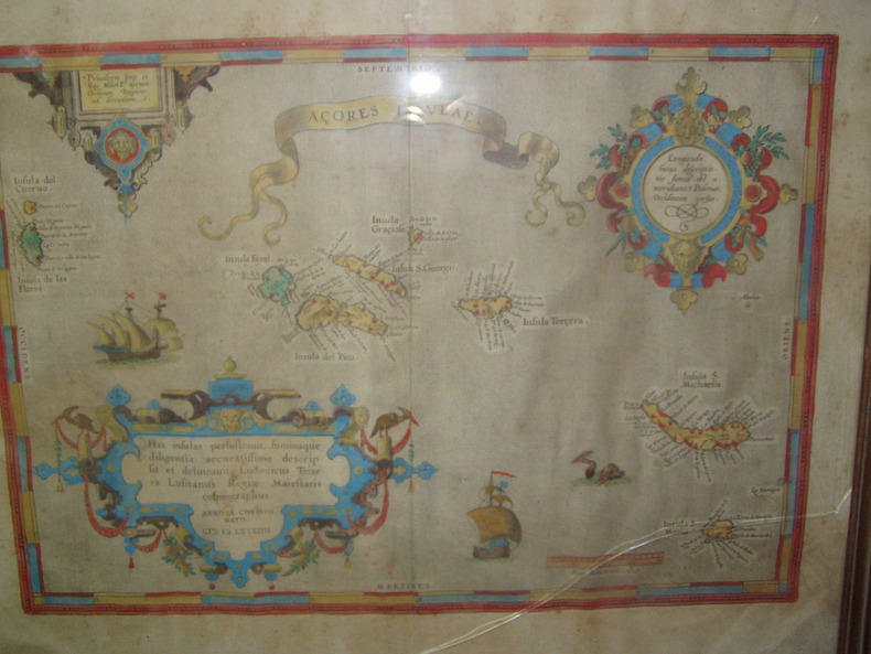
1584224251584 Orig. copper-engraving. Published by A. Ortelius after to L. Teixeira's map of the Açores. Dated 1584. Coloured. With title in decorative border, 3 ornamental cartouches, 2 ships, sea-monster and "Scala Leucarum". 32,5:46,5 cm (12 3/4 x 18 1/4 inch.) 2,5 x 46,5 cm Van der Krogt, Koeman's Atlantes Neerlandici, Vol. III B, 6350:31; Van den Broecke, Ortelius Atlas Maps, Nr. 24. - Stammt aus einer von fünf lateinischen Ausgaben, die in den Jahren 1595 - 1612 erschienen. Alle tragen das Datum 1584 in der großen Kartusche.A splendid sea chart of the Azores with three scrollwork cartouches; the ocean is decorated with sailing vessels. A fresh example of this scarce sea chart, based on Teixeira's single sheet map of Terceira from 1582, and a later manuscript atlas of the Azores islands. The Azores played a significant role in international sea trade as a victualling stop and shelter for ships sailing into the South Atlantic. In very good condition. The map was first issued in an edition of 100 examples in the Additamentum to the 1583 edition of Ortelius' Theatrum Orbis Terrarum, which is widely referred to as the first modern atlas and a landmark in the history of Western map making. Beginning in 1570, Abraham Ortelius and his successors published (and continuously added to) this monumental work for a period of over 40 years (not including the very rare edition of 1641), with text on the verso in Latin, Italian, German, Dutch, French, Spanish and English.References: Van Den Broecke 24. Meurs p 253-254.
15950044301595 [Anvers], Ortelius, 1594. Carte (557 X 405 mm, marges comprises) sous cadre en bois noirci moderne.
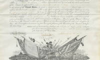
15073254115/07/1864. <blockquote><p>A real rarity the first Lincoln appointment to the Signal Corps for an officer active in Sherman’s Georgia Campaign we have seen</p></blockquote><p>On March 29 1860 the United States House of Representatives approved the Army appropriations bill for fiscal year 1861 which included the following amendment: ""For the manufacture or purchase of apparatus and equipment for field signals $2000; and that there be added to the staff of the Army one signal officer with the rank pay and allowance of a major of cavalry who shall have charge under the direction of the Secretary of War of all signal duty and all books papers and apparatus connected therewith."" The United States Senate eventually approved the appropriations bill over the objections of Jefferson Davis now Senator from Mississippi and President James Buchanan signed it into law on June 21 1860 the date now celebrated as the birthday of the modern U.S. Army Signal Corps.</p><p>Now armies on the go could report back to their civilian leadership in real time and those leaders could make decisions without waiting for a messenger on horse. This changed the face of warfare. President Lincoln himself spent significant time in the telegraph office sending and receiving war correspondence. He often walked alone from the White House to the office and chatted with the operators. As Bates later wrote “During the Civil War the President spent more of his waking hours in the War Department telegraph office than in any other place except the White House. While in the Telegraph Office he was comparatively free from official cares and therefore more apt to disclose his natural traits and disposition than elsewhere under other conditions.â€</p><p>John Quincy Adams first enlisted in 1862 with the 38th Ohio Volunteers. On October 15 of that year he was a quartermaster sergeant with the 10th Ohio Cavalry. After a stint as acting lieutenant on July 15 1864 he was appointed by the President Second Lieutenant to date from March 3 1863. Adams was actively involved in the Georgia campaign conducted by Gen. William T. Sherman. He was with left wing of the 16th Army Corps on the march to Chattanooga Tenn. In the Atlanta Campaign he participated in the battles of Resaca Dallas Kenesaw Mountain. and Jonesboro. He manned signal corps stations at Kenesaw Mt. and Allatoona.</p><p>Adams was in the engagements at Port McAllister and Rice Mill station in the campaign from Savannah through the Carolinas including battles at Columbia Bentonville and Raleigh; and at the surrender of Confederate Gen. Joseph E. Johnston to Sherman on April 26 1865. Adams was breveted 1st lieutenant for gallant and meritorious service in the Signal Corps at the battle of Allatoona; he was breveted captain for gallant and meritorious services in the Signal Corps at the capture of Fort McAllister and Savannah and throughout the war. Adams was mustered out August 22 1865. After the war he was in the 1st U. S. Cavalry and was in the Indian wars and finished his career as captain and aide to Gen. O.O. Howard in October 1884. He is listed on the roster of the U.S. Signal Corps in the Civil War.</p><p>Adams is also a protagonist in one of the most famous telegraph exchanges of the war during the battle near Allatoona. During this battle legend goes that Sherman signaled to General Corse and his men to ""hold the fort"" a phrase that inspired the later popular religious hymn entitled Hold the Fort by Chicago evangelist Philip P. Bliss which featured the chorus 'Hold the fort for I am coming’ which then became a common expression. We still use ""hold down the fort"" today. Adams was the signal officer who received that message or rather a variant as Sherman did not use that exact phrase though captured the sentiment.</p><p>This is President Lincoln’s appointment of Adams as Second Lieutenant. <strong>Document signed</strong> Washington July 15 1864 naming Adams <em>""Second Lieutenant in the Signal Corps""</em> dating from the third of March 1863.</p><p>This document is a real rarity as we have never before seen a Lincoln appointment to the Signal Corps for an officer active in Sherman’s March to the Sea. Moreover Lincoln Signal Corps appointments are themselves uncommon this being our first.</p><p>It was acquired from the Adams descendants and has never been offered for sale before.</p><p><img class=""alignnone wp-image-25018 size-post-window"" src=""https://cdn.raabcollection.com/wp-content/uploads/20231204144051/Folder-site-11-1600x1327.jpg"" alt="""" width=""1600"" height=""1327"" /></p> unknown