Abraham LincolnBiblio.com
213 résultats
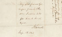
15093547615/09/1863. <blockquote><p>The letter itself was from Lamb a pallbearer after Lincoln's assassination</p></blockquote><p>Joseph Gillespie was a Whig member of the Illinois Assembly in 1840-41 and then served in the State Senate from 1847 to 1859. He joined the Republicans in 1856. Gillespie chaired the Illinois Republican State Convention in 1860 where presidential electors were selected who would vote for Abraham Lincoln and served as circuit court judge in Southern Illinois from 1861 to 1873.</p><p>From when they met in 1840 Gillespie was a key political ally lawyer and trusted and intimate friend to Abraham Lincoln. They consulted on legal cases and in political matters where they kept each other informed of political developments. Gillespie visited President-elect Lincoln at Springfield before he left for Washington. When Lincoln was president Gillespie occasionally went to Washington to see him and kept him informed about the political situation in the western states. Their correspondence shows a close personal bond.</p><p>James L. Lamb was a meatpacker industrialist and friend of Lincoln from Illinois known for his business dealings with the future President and his role as one of the pallbearers at Lincoln's funeral. In a letter addressed to President Lincoln Lamb wrote him from Springfield Ill. September 10 1863 to secure a position for a relative. “My friend and relative Mr. James H. Lea is an applicant for the position of paymaster in the army. His appointment I am sure would meet the approbation of all true friends of the Government who are acquainted with him. I have long known him as a reliable competent businessman and one whose integrity could be fully relied upon. His moral character is without blemish and the most satisfactory assurances can be given of his integrity and fitness for the position.†The docket states “Springfield Sep. 10/63 James L. Lamb to the President. Application for appointment of James H. Lea as a Paymaster.â€</p><p>This letter was not mailed by Lamb to Lincoln. Instead Lamb gave the letter to Gillespie to enlist his support and use his influence with Lincoln. Gillespie presented Lamb’s letter to Lincoln with his request that it be honored.</p><p><strong>Autograph endorsement signed</strong> Washington September 15 1863. <em>“My old friend Gillespie presents this; and I would like for him to be obliged.†</em>This is unpublished and not in Basler’s Collected Works of Abraham Lincoln. The wording of Lincoln’s endorsement saying that Gillespie presented this to Lincoln and the implication that Gillespie will need to be presenting this to the Secretary of War raises the possibility that Gillespie handed this to Lincoln in person and then took the endorsement to Stanton.</p><p>On October 10 Gillespie wrote Lincoln that the appointment had not yet been made and relating a communication with Stanton saying<em> “I would beg to call your attention to the subject of the appointment of my friend James H. Lea of Alton to the office of paymaster in the regular army. Secy. Stanton told me that he would retire one now on the list to make place for Mr Lea in a short time. I have heard nothing from him since. I would take it as a great favor if this thing could be done soon. I am aware how much you must be pressed with business of an engrossing character at this juncture but hope you may find leisure to jog the secretary’s memory.â€</em></p><p>According to papers in the Library of Congress James H. Lea was appointed an additional paymaster of volunteers to rank from February 23 1864. He signed his oath of office in April.</p><p>This is a fascinating endorsement showing how Lincoln sought to assist his old friends to the extent he appropriately could.</p><p><img class=""alignnone wp-image-25018 size-post-window"" src=""https://cdn.raabcollection.com/wp-content/uploads/20231204144051/Folder-site-11-1600x1327.jpg"" alt="""" width=""1600"" height=""1327"" /></p> unknown
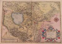
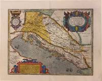
158728094Antwerp: Ortelius 1587. Maps. Overall in very good condition. A very nice example of Ortelius' famous map of the Kingdom of Prester John with later hand color. It is from a Latin edition of Ortelius' Theatrum Orbis Terrarum the first modern atlas of the world. <br /> <br /> Cartographica Neerlandica Background for Ortelius Map No. 175. The map is difficult to date. The following details correspond to the aforementioned bibliography - it is consistent with 175.2 as the coastline has hatching extended from about 3 to about 6 mm signifying from 1587 & beyond. The ship in the lower left corner has a vessel attached to its mast. In the first state this vessel has vertical hatching. Now this is changed to horizontal hatching. In this copy the frame around the map has curved oval hatching around its oval ornaments. The sea was not re-engraved in later editions and as they are strongly engraved in this copy it would indicate an earlier edition. There is a watermark of two crossed arrows measuring 10 cm in length. The last line of text on the verso reads "uerit vide Jacobum Nauarchum in sua epistola Asiatica & Gerardum Mercatorem in sua universali tabula. 89". <br /> "Ortelius 1579 is penciled on the verso by an unknown person but that is unknown.<br /> <br /> The map centers on "Africva" in a strange configuration which goes from the coast of Benin and the "Mare Aethiopicum" to the Arabian Sea titled "Barbaricus Sinus". Arabia Felix covers the area of Saudi Arabia and adjoining countries with the Red Sea between the Arabian Penninsula and the coast of Africa. Mecca Medina and Jerusalem are noted with large buildings indicating their importance and colored red.<br /> <br /> Prester John was a mythical African King waging a war against the Muslim Infidels from his Kingdom in Central Africa. Add the Byzantine Patriarch Crusaders Islamic Saracens the Portuguese and a fake letter for this For centuries from the receipt of a fake letter from Prester John to the Byzantine Patriarch Europeans searched for Prester John initially in Asia and later in Africa. The Crusaders hoped that Prester John would join with Europeans in the protection of the Holy Lands from the Islamic Saracens and in the protection of all Europe from the Mongols. In the late 1400s and early 1500s the Portugese searched for Prester John in East Africa through they did eventually find a Christian kingdom in Abyssinia. A dedication to King David of the Bible is in the upper left of map. Above the dedication is the coat of arms of Prester John. Elephants and other figures adorn the map. <br /> <br /> Copper engraving with period hand color 17.5 x 15" with wide margins. Text in Latin on the verso. Two small wormholes in the top margin. Ortelius unknown
1598LBW-1384Anvers 1598 81 x 106 mm.
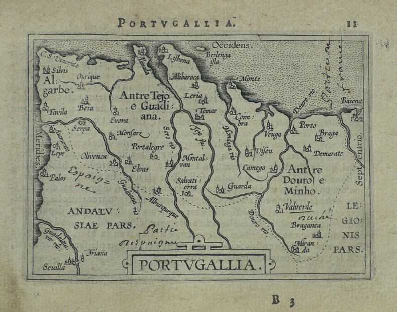
1579M11348Antwerp Belgium 1579. Very Good. Notes: Highly decorative and detailed map of Portugal with two elaborate cartouches. <br>Latin text on verso.<br>Abraham Ortelius April 1527 – June 1598 was a Flemish cartographer geographer and cosmographer from Antwerp in the Spanish Netherlands. He is recognized as the creator of the first modern atlas the Theatrum Orbis Terrarum Theatre of the World. Along with Gemma Frisius and Gerardus Mercator Ortelius is generally considered one of the founders of the Netherlandish school of cartography and geography. He was a notable figure of this school in its golden age approximately 1570s–1670s and an important geographer of Spain during the age of discovery. The publication of his atlas in 1570 is often considered as the official beginning of the Golden Age of Netherlandish cartography. Size : 342x520 mm 13.46x20.47 Inches Coloring: Original Hand Coloring Reference: Van den Broecke #26. Category: Maps Europe Portugal; unknown
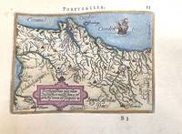
1588M11346Antwerp Belgium c.1588. Very Good. Notes: A miniature map of Portugal.<br>French text on verso. <br>Abraham Ortelius April 1527 – June 1598 was a Flemish cartographer geographer and cosmographer from Antwerp in the Spanish Netherlands. He is recognized as the creator of the first modern atlas the Theatrum Orbis Terrarum Theatre of the World. Along with Gemma Frisius and Gerardus Mercator Ortelius is generally considered one of the founders of the Netherlandish school of cartography and geography. He was a notable figure of this school in its golden age approximately 1570s–1670s and an important geographer of Spain during the age of discovery. The publication of his atlas in 1570 is often considered as the official beginning of the Golden Age of Netherlandish cartography. Size : 78x110 mm 3.07x4.33 Inches Coloring: Hand Colored Category: Maps Europe Portugal; unknown
1590003611Belgico Antwerp: Abraham Ortelius 1590. No Binding. Very Good. Elephant Folio - over 15" - 23" tall. ORTELIUS Abraham. VG 1590 B&W Map of the Black Sea Coast. 50 35.5 the Map 54 44.5 cm map including margins. Latin Text to verso of 1 side p xxvii. No pin holes inscriptions etc very light edge browning. Includes part of Ukraine Russia Georgia Bulgaria Romania and Turkey. Belongs to a series of historical maps known as the Parergon Theatri from 1579 onwards. Tooley's Dictionary of Mapmaker Early World Press 2004 p358-359 Marcel P. R. van den Broecke Ortelius Atlas Maps HES Publishers 2011 p633. <br/> <br/> Abraham Ortelius unknown
15739404Antwerp 1573. Three engraved maps on one sheet 38.5 x 50 cm black and white very faintly red-ruled slight marginal soiling Latin text on verso; old tabs on verso where previously mounted. An early example of this particular map which was first printed in Dutch German and Latin editions of Ortelius Theatrum in the same year 1573. Pomerania running along the Baltic coast between Rostock and Gdansk is now divided between Germany and Poland; Livonia covers much of modern Latvia and Estonia; the Duchies of Oswiecim and Zator were two of the Duchies of Silesia in modern Poland. Ortelius's Theatrum Orbis Terrarum is generally considered the first modern atlas of the world originally published in 1570. Ortelius gathered the best available cartographic knowledge and presented it in a consistent style in a single volume with text. The Theatrum was very decorative and hugely popular amongst the wealthy and educated running into over forty editions in Latin and the major European languages. Marcel Van den Broecke Ortelius Atlas Maps no. 158. Map unknown
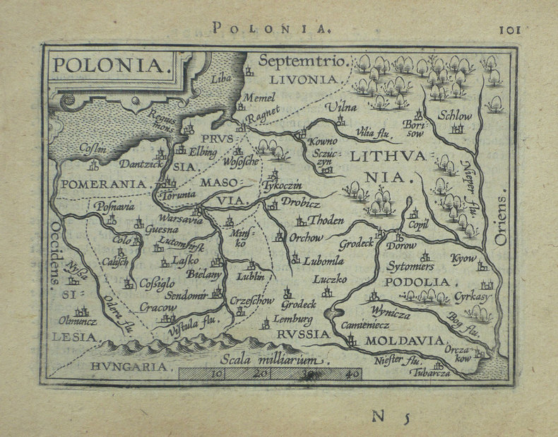
1598M3122Antwerp c.1598. Very Good. Notes: Scarce map of Poland and Lithuania during the late 16th century. <br>The map shows major cities and towns as well as geographical features. Includes a charming image of a horse-drawn sleigh in the bottom right corner. <br>Dutch text on verso. Size : 369x482 mm 14.53x18.98 Inches Coloring: Hand Colored Category: Maps Europe Poland Lithuania; unknown
1584001117Antwerp: Christopher Plantin 1584. Map. Fine. Framed. Size: 377 x 485 mm. Framed size: 580 x 465mm. Hand-coloured engraved map published in the Theatrum Orbis Terrarum. Wooden moulding frames glazed and mounted late 20th century. In fine condition only a small two spots in a upper part. A beautiful map of Poland and Lithuania part of the Baltic Sea title in cartouche at lower left in Latin scale at top left decorated sleigh with a horse. . Christopher Plantin Hardcover
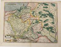
1574M6759Antwerp Belgium: Abraham Ortelius 1527-1598 1574. Very Good;. Notes: Latin text on verso. L58.<br><br>"Waclaw Grodecki his true name was Grodziecki which was latinized as Grodecius corrupt Godreccius was born about 1535. He was the son of a Silesian gentleman to whom belonged the village Grodziec in Cieszyn Silesia hence the family name. He entered Cracow University in 1550 and in 1555 was still there studying mathematics and philosophy. In 1556 he left for Leipzig as tutor to the son of a great noble and there too he entered the university. In 1557 he drew his well-known map of Poland. He travelled to Italy and after his return in 1561 took orders. In 1564 he received the degree of Master of Arts at the Cracow University. He later became canon of the chapter in Wroclaw this post having been ceded on his behalf by his elder brother Jan when he became bishop of Olomouc in 1572. Waclaw Grodecki followed his brother to Moravia in 1566 and settled for good in Brno where later he became dean of the collegiate chapter. Being to the end of his life a devoted Catholic and a protector of the Jesuits he was a major figure of the counter-reformation movement in Moravia. He was a man of humble character and good-natured. He died in Brno in 1591." Buczek<br> <br> Size : 373x498 mm 14.69x19.61 Inches Coloring: Original Hand Coloring Reference: Marcel P. R. van den Broecke #154. Category: Maps Europe Poland Lithuania; Abraham Ortelius (1527-1598) unknown
1598LBW-1390Anvers 1598 82 x 108 mm.
15703399<p>Very Good. 1570. 16th century map with original hand-colored outlines of the region of Poictou. Decorative cartouche. Some foxing most apparent to margins. Otherwise a handsome copy. Please see image. Plate size approximately 19 1/2 x 14 in. Overall size approx. 21 1/4 x 16 3/4 in 537 x 425 mm.; 1 pages; All shipments through USPS insured Priority Mail. .</p>
15843014<p>Map. Paper size: 422 x 530 mm. Image size: 330 x 465 mm. 16th century map in original hand-coloring. Decorative polychrome cartouche and compass rose. Depicts bodies of water heights and towns/cities. Latin text to verso. Van den Broecke 2nd ed. 1584 L3.; 422 x 530 mm.; All shipments through USPS insured Priority Mail.</p> Abraham Ortelius
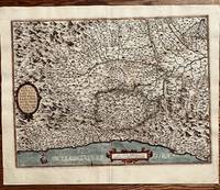
158453174Antwerp. c.1584. Based on Egnatio Dante's 1580 Perugia map engraved by Mario Cartaro. Decorated strapwork cartouche at lower right scale at lower left and compass point at centre right empty cartouche at top left. Published in Ortelius' epic atlas the Theatrum Orbis Terrarum. Copper engraving. A little darkened but clean with good margins. Expert repairs to cracks. caused by verdi gris. Closed tear at lower margin not affecting map.Very good condition. Original colour. Size: 33.4 x 47 cm. van den Broecke 136. unknown
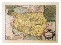
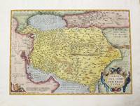
1574G1ADU6GU6IANAntwerp: Christophe Plantin 1574. Engraved map 35 x 50 cm in contemporary hand-colouring and highlighted in gold. Scale 1:9000000. 16th-century Dutch map of Persia based on the Gastaldi map with additional new cartographic information.l Alai General maps E.70; Al-Qasimi 30; Van den Broecke 167 first state. Christophe Plantin, unknown
1595M457Antwerp 1595. Very good. Size : 352x504 mm 13.875x19.875 Inches Coloring: Hand Colored Reference: Marcel P. R. van den Broecke "Ortelius Atlas Maps An Illustrated Guide" map 167. Category: ; Maps Asia Middle East Iran Iraq unknown
1584673Antwerp: Abraham Ortelius 1584. 19 1/2 x 14 1/2 inches. Very good condition. This is an exquisite map of Italy with Monaco in the west. and Milano in the Northeast. It shows the coast of the Mediterranean Sea at the borrow/ There is an extensive river network flowing throughout a mountainous terrain.The Po river dominates the central portion of the maps. This is an example of the best of the mapmakers art. This is nicely colored in a later than issued application. Abraham Ortelius unknown
157513973Antwerp: Juan Baptist Vrients 1575. Other. In excellent condition. 368 by 495mm 14 by 19 inches. Original antique copper engraving uncolored from the 'Theatrum Orbis Terrarum' by Abraham Ortelius the world's first modern atlas published in Antwerp 1575. Depicting Piedmont this map is a fine example of 1570s European cartography. Image: 368 by 495mm 14 by 19 inches. An attractive and historically significant 16th-century map for the discerning collector. Abraham Ortelius 15271598 was a Flemish cartographer and geographer born in Antwerp. He is widely regarded as the creator of the first modern atlas the 'Theatrum Orbis Terrarum' Theatre of the World first published in 1570 by Gilles Coppens de Diest in Antwerp. Considered the world's first true atlas it established the modern format of uniform standardized maps bound together in a single volume. Appointed Geographer to King Philip II of Spain in 1575 Ortelius was one of the most influential figures in the history of cartography. His maps are held in the collections of the British Library the Library of Congress and major European institutions. The 'Theatrum' went through more than 30 editions and was translated into multiple languages making Ortelius's maps among the most sought-after in the world of antique cartography.The Piedmont region is based in the middle on these map of Giacomo Gastaldi. Milan is in the upper right and Monaco is at lower left corner. The map is a great illustration of the mountainous countryside and is filled with information including even the tiniest of villages. Decorated with two cartouches and a sailing ship in the Mediterranean.A fine example from Theatrum Orbis Terrarum Antwerp sought after by collectors of antique maps of Italy antique maps of Piedmont and antique copper engraving uncoloreds for sale. In good condition consistent with age. Light age-toning to the sheet as expected for a 16th-century engraving. Centerfold as published. Broe: 128 Juan Baptist Vrients unknown
15753397<p>Very Good. 1575. 16th century map with original hand-colored outlines of the Italian region of Piedmont. Decorative cartouche. Some foxing most apparent to margins. Otherwise a handsome copy. Latin text to verso with colored historiated initial. Please see image. Plate size approximately 19 1/2 x 14 1/2 in. Overall size approx. 21 3/4 x 16 3/4 in 530 x 427 mm.; 1 pages; All shipments through USPS insured Priority Mail. .</p>
1590M9803Antwerp c.1590. Very Good. Notes: Latin text on verso. A beautiful map of the Balkans. Size : 352x455 mm 13.86x17.91 Inches Coloring: Original Hand Coloring Category: Maps Europe Balkans; unknown
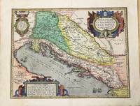
1595303401Antwerp: Abraham Ortelius 1595. Map. Engraving with original hand coloring. Image measures 14" x 18 1/8". Sheet measures 17" x 21 3/8"<br/> <br/> Beautifully colored map of the classical regions of Pannonia and Illyria Dalmatia lying on the northeastern coast of the Adriatic Sea. Depicts present-day Croatia Bosnia and Herzegovina and Montenegro. Shows classical place names topographical and geographical features. Latin text on verso. From "Theatrum Orbis Terrarum". Light scattered stains to margins and cartouche. Minor abrasion to upper right. <br> <br> Abraham Ortelius 1527--1598 a Flemish cartographer and geographer is widely regarded as one of the important and influential cartographers in history. He is known for his "Theatrum Orbis Terrarum" which was the first modern atlas. van den Broecke 203.<br/> <br/> Abraham Ortelius unknown
1595M6473Antwerp: Ortelius c. 1595. Very Good; margins shaved. Notes: "From 1595L onwards this successor of plate 171 a previous edition of the map which has 4 ships instead of the 3 on this plate and "SIGENENSI" instead of "SIGENENS" in the cartouche moves to the Parergon. Bertius bought a number of sheets with this map and included the map in his historical 1619 atlas 'Theatrum Geographiae Veteris'." van den Broecke Size : 340x457 mm 13.39x17.99 Inches Coloring: Hand Colored Reference: Marcel P.R. van den Broecke 172<br>Tooley 358 Category: Maps Asia Middle East Holy Land & Palestine; Maps Africa North Egypt; Ortelius unknown
1592272534Antwerp: Abraham Ortelius 1592. unbound. Map. Engraving with hand color. Image measures 14" x 18 3/4".<br/><br/> This beautiful 1592 map by Abraham Ortelius depicts the Balkan Peninsula or the Balkans extending from The Sea of Marmara Istanbul and the Bosporus Strait westward to Macedonia including Bulgaria. Portions of the Black Sea and the Thrakikon Pelagos are also shown. Topographical and geographical features such as mountains forests and cities are beautifully rendered in profile.<br><br>Ortelius based this map on the 1560 South-East Europe map by Gastaldi and on on information from numerous ancient sources specifically Herodotus Plinius Strabo Appianus Virgilius Plutarchus and Sidonius. A beautifully engraved title cartouche adorns the top left of the map. Two additional cartouches containing text are also included in the top and bottom right.<br><br>This map was published in the 1592 edition of Ortelius's famous "Theatrum Orbis Terrarum" which is historically considered the first modern atlas. Based on the Latin text on verso only 525 copies of this particular atlas were ever printed van der Broecke 214. The map is in good condition with minor wear and toning along the original centerfold. Light stain in lower left margin. Minor foxing with Latin text on verso.<br><br>Abraham Ortelius 1527--1598 a Flemish cartographer and geographer is widely regarded as one of the important and influential cartographers in history. He is known for his "Theatrum Orbis Terrarum" which was the first modern atlas. Van den Broecke #214<br/><br/> Abraham Ortelius unknown books
156821922Antwerpen: Platin 1568. Other. In excellent condition. 343 by 510mm 13 by 20 inches. Original antique copper engraving hand colored in outline when published. German text edition. Shows West and East Frisia with the islands. Decorative cartouche with card title lower right. Cartridge with mileage indicators in the lower center; in the Zuidersee Ijsselmeer compass rose; the map is illustrated with numerous sailing ships. Rare 1st condition with German back text. Ortelius was born on 14 April 1527 in the city of Antwerp which was then in the Habsburg Netherlands modern-day Belgium. The Orthellius family were originally from Augsburg a Free imperial city of the Holy Roman Empire. In 1535 the family had fallen under suspicion of Protestantism. Following the death of Ortelius's father his uncle Jacobus van Meteren returned from religious exile in England to take care of Ortelius. Abraham remained close to his cousin Emanuel van Meteren who would later moved to London. In 1575 he was appointed geographer to the king of Spain Philip II on the recommendation of Arias Montanus who vouched for his orthodoxy. He travelled extensively in Europe and is specifically known to have traveled throughout the Seventeen Provinces; in southern western northern and eastern Germany e.g. 1560 15751576; France 15591560; England and Ireland 1576; and Italy 1578 and perhaps twice or thrice between 1550 and 1558. Beginning as a map-engraver in 1547 he entered the Antwerp Guild of Saint Luke as an illuminator of maps. He supplemented his income trading in books prints and maps and his journeys included yearly visits to the Frankfurt book and print fair where he met Gerardus Mercator in 1554. In 1560 however when travelling with Mercator to Trier Lorraine and Poitiers he seems to have been attracted largely by Mercator's influence towards the career of a scientific geographer. Wikipedia Broe: 80 Platin unknown
1590910274CGAntwerpen:, Ortelius, nach 1590. Kupferstich 31 x 23,5 cm (hoch), Blattgröße 41,5 x 26,5 cm.