1 546 résultats
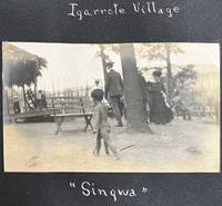
190462227St. Louis MO: n.p. 1904. Oblong 4to. 10.25 x 7 in. 24 pp unpaginated. on thick black paper stock 27 mounted silver gelatin photographs nearly all sized 3.25 x 5.5 in. annotated below or alongside in white ink manuscript. Contemporary self-printed black paper covers white lettering printed on front cover title in white ink manuscript punch-sewn at spine w/ red silk braid minor edgewear slight bumping to 1 corner minor over-exposure to some of the images still a VG exemplar. An original vernacular souvenir photo album created by an unknown amateur photographer documenting their tour of the famed 1904 St. Louis World Louisiana Exposition World’s Fair using their own camera -- typically after paying an entrance fee as inaugurated at the 1893 Columbia Exposition over 10 years before. The album opens with views of the Palace of Liberal Arts Festival Hall and the fountains Terrace of the States Electricity Palace Education and more. Along with many of the general public fair-goers these photographs reflect a fascination with the ethnological “Human Zoo†exhibits at the Exposition including the Igarrote-Filipino Village with one young child striding in the fore-ground the Philippine Restaurant and view of the Village with huts temple and walled city. Also featured are a few of the Japanese tea garden and pavilion and the Chinese temple exterior and interior. The photographer also captured the Life-Saver’s Exhibit by the Lifesaving Service; the Jefferson City Guards marching in front of the Austria & Sweden Buildings as well as the entrance to “the Pike†with visits to the Japanese Roof Garden Restaurant Beer Garden and German Coffee House. [n.p.], unknown
18116624AWien, Bauer, 1810/1811. 8°. Bde. 1 und 2 von 3 Bdn. 336, 360 Seiten. Mit 2 gestochenen Frontispizen. Pappbände der Zeit mit Rückenschildern. Rücken etwas angestaubt, sonst tadellos.
17684A-8PARIS, GANEAU (DE L'IMPRIMERIE D' HOURY), 1768. IN-8° (185x115mm), XX - 372 - 2ff., 1 CARTE DÉPLIANTE, FAUX TITRE ET TITRE TACHÉS, PIQÛRES, TRÈS CLAIRE MOUILL. MARG. AU MILIEU DE L'EXEMPLAIRE. BROCHÉ, DOS SALI. UNIQUE ÉDITION DE CET OUVRAGE BASÉ SUR CELUI DU BOTANISTE PEHR KALM POUR L'HISTOIRE NATURELLE ET SUR LE VOYAGE DE GOTTLIEB MITTELBERGER POUR LA PARTIE CONSACRÉES AU QUAKERS. ILLUSTRÉ D'UNE CARTE DÉPLIANTE. UNIQUE FRENCH EDITION OF THIS DESCRIPTION OF PENNSYLVANIA BASED ON THE WORKS OF KALM AND MITTELBERGER. ILLUSTRATED WITH 1 FOLDING MAD. SEWED (FIRST LVS STAINED, FOXING).
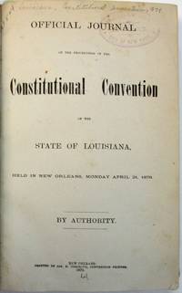
187936489New Orleans: Jas. S. Cosgrove Convention Printer 1879. 337 1 blank 156 pp plus two folding tables. Each page printed in two columns. Bound in buckram with gilt-lettered morocco spine labels light rubberstamp on title page. Clean text. Very Good. Last leaf with a tear affecting about five letters of a two-page report in the Appendix concerning drainage and taxation in the City of New Orleans.<br /> <br /> The Convention dominated by white Democrats returned Louisiana to Home Rule. It was consumed with issues of State debt financial auditing bonds and the public treasury. One delegate expressing his colleagues' deep resentment of Reconstruction asserted that "the deplorable gloomy and painful condition of Louisiana must be the result of the most barefaced prostitution of power the most barefaced abuse of sacred trusts and the most infamously corrupt application of the people's money" page 298. The Journal a day-by-day account of these Proceedings does not print the Constitution. <br /> Not in Marke Harv. Law Cat. Thompson. Jas. S. Cosgrove, Convention Printer unknown
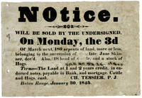
1845WRCAM36605Baton Rouge La 1845. Broadside 6 1/2 x 9 1/2 inches. Moderate dampstaining and age-toning. Contemporary annotation partially covered over in contemporary ink. Two small holes in margin not affecting text. A good copy. An unrecorded mid-19th-century Louisiana broadside advertising the sale on March 3 1845 of 180 arpents approximately 153 acres which belonged to the heirs of the late Jane Skinner and eighteen head of cattle and an unspecified number of hogs. The terms for purchase are also noted: "The Land at 1 and 2 years credit in endorsed notes payable in Bank and mortgage. Cattle and Hogs cash." The notice is signed in print "Ch. Tessier" possibly a justice of the peace and dated Baton Rouge January 30 1845. A rare Louisiana advertising broadside; no copies recorded in Hummel or OCLC. unknown books
187936489New Orleans: Jas. S. Cosgrove Convention Printer 1879. 337 1 blank 156 pp plus two folding tables. Each page printed in two columns. Bound in buckram with gilt-lettered morocco spine labels light rubberstamp on title page. Clean text. Very Good. Last leaf with a tear affecting about five letters of a two-page report in the Appendix concerning drainage and taxation in the City of New Orleans.<br/><br/> The Convention dominated by white Democrats returned Louisiana to Home Rule. It was consumed with issues of State debt financial auditing bonds and the public treasury. One delegate expressing his colleagues' deep resentment of Reconstruction asserted that "the deplorable gloomy and painful condition of Louisiana must be the result of the most barefaced prostitution of power the most barefaced abuse of sacred trusts and the most infamously corrupt application of the people's money" page 298. The Journal a day-by-day account of these Proceedings does not print the Constitution. <br/>Not in Marke Harv. Law Cat. Thompson. Jas. S. Cosgrove, Convention Printer unknown books
180311298Washington 1803. 5pp later stitching. Light wear Very Good. <br/> offered with SUPPLEMENTARY REPORT.RELATIVE TO THE MEANS BY WHICH THE MAIL MAY BE CONVEYED WITH GREATER DISPATCH THAN AT PRESENT BETWEEN THE CITY OF WASHINGTON & NATCHEZ AND NEW ORLEANS.12TH JANUARY 1804. READ AND REFERRED TO A COMMITTEE OF THE WHOLE HOUSE ON MONDAY NEXT. 1804. 4pp later stitching light wear. Very Good. <br/><br/> "The late cession of Louisiana by France to the United States renders it an object of primary importance to have the nearest and most expeditious mode of communication established between the city of Washington and the city of New Orleans the capitol of that province." The Committee thus urges a post road from Washington "to pass through or near the Tuckabachee settlement to the Tombigby settlement in the Mississippi territory and from thence to New Orleans. And further that a post road ought also to be established from the said Tombigby settlement to Natchez." Recognizing however that the route includes "a distance of nearly four hundred miles wholly uninhabited by citizens of the United States" in the Mississippi Territory the Committee adds that the precise route cannot be determined "until this unimproved territory has been explored." <br/>FIRST EDITIONS. AI 5472 3 7633 2. unknown books
186433590Natchitoches LA: Printed at the "Times" Office- Louis Dupleix Proprietor 1864. 48pp printed in English only as issued. Disbound old institutional rubberstamp on blank portion of title page. Else Very Good.<br/><br/> A scarce Confederate imprint which the Times Office also issued in a more common version with English and French on opposite pages. Much material on the prosecution of the War.<br/>Parrish & Willingham 2992 1- LNHC only. For the English-French printing see P&W 2991 11 locations. Printed at the "Times" Office- Louis Dupleix, Proprietor unknown books
ria9780471109457_inpHardback. New. New Book; Fast Shipping from UK; Not signed; Not First Edition; Kinematic wave modeling methods are gaining wide acceptance as a fast and accurate way of handling a wide range of water modeling problems. This book provides a thorough reference to the application of KW methods to such problems as the hardcover
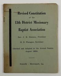
19594635Shreveport La 1959. Very good. 8pp. Original printed wrappers stapled. Minor toning around the edges short split to spine. A very rare if not unrecorded African American religious pamphlet from Jim Crow Louisiana. This revised constitution was printed to govern the Thirteenth District Missionary Baptist Association in Shreveport in 1959. The purpose of the organization is "to promote and support Home and Foreign Missions contribute to Christian Education to develop and maintain Christian Unity and to give AID to struggling churches also to foster Charitable Institutions." The constitution provides rules for membership officers the duties of officers meetings departments within the association the presbytery and more. No copies listed in OCLC. unknown
192041169Washington D.C.: Published by the United States Coast and Geodetic Survey 1920. Large folding nautical chart printed on heavy paper stock. Colored. A rare original coastal survey of the Barataria Bay area and includes Grand Isle Grand Terre Island and the Mississippi River.<br/> <br/> Established by President Thomas Jefferson in 1807 as the Survey of the Coast the U.S. Coast and Geodetic Survey was the United States' first civilian scientific agency. This agency has followed its mission to survey the U.S. coastline create nautical charts of the coast and help increase maritime safety since its founding and has often played fascinating roles in significant chapters of U.S. history. It served in all theaters of the Civil War in the service of the Union Army and Navy pioneered acoustic exploration in the wake of the sinking of the Titanic and during WWI it worked to detect enemy submarines. In addition this agency worked to survey and produce detailed maps and renderings of the U.S. coast. These nautical survey maps commonly referred to as "T-sheets" provide fascinating insights into the history of the United States coastline which has and will continue to shift. These maps are the most important data source for understanding the physical and ecological characteristics of the U.S. shoreline. The present map of the Louisiana coastline is notable for the inclusion of Grand Isle the only inhabited barrier isle of Louisiana and of Barataria Bay which used to be frequented by pirates including Privateer Jean Lafitte. It is a highly detailed and accurate sea chart of the Barataria Bay and an important historical view of the developing Louisiana. Published by the United States Coast and Geodetic Survey unknown
19192278Crowley 1919. About very good. 31pp. 16mo. Original printed wrappers stapled. Moderate soiling to covers contemporary pencil ownership notation on front cover. Doodle inside front cover. Minor soiling internally. "The city that sets the pace in the race for prosperity in the rice belt takes nobody's dust and keeps her head turned always in the direction of success." A promotional work for the city of Crowley Louisiana located in the south-central portion of the state. The work is extensively illustrated with views of the city as well as scenes of rice fields and a map of the state showing Crowley's location and all of the railroads that connect it to the wider world. We locate four copies in OCLC -- University of Alabama Yale University of Louisiana at Lafayette and the Louisiana state library. unknown
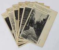
19203617Hammond La: Vindicator Job Print 1920. Very good. Six photographically-illustrated postcards each 5.5 x 3.5 inches. Minor edge wear some toning around the edges and at corners one slightly misprinted with very minor loss of text. A visually-interesting group of a half dozen promotional postcards picturing various locations around Hammond Louisiana issued by the Hammond Real Estate & Investment Company Limited. The company encourages potential emigrants and investors to contact them: "If you want to know about Hammond and vicinity write to the Hammond Real Estate & Investment Company Limited." The photographs on the postcards feature distinct locations and each is printed with a different caption at lower right. These captions read: "A Country Road" "Pines and Palmettoes" "A River Drive" "The Tangipahoa River" "The 'Hammond Oak'" and "Oak Street." The printer Vindicator Job Print was the local newspaper started in 1892 as the Hammond Graphic and by 1919 was known as the Hammond Vindicator. No results found in OCLC. Vindicator Job Print unknown
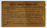
19143424N.p. likely near Bogalusa La 1914. Very good. 5pp. on a single folded sheet of cardstock. Oblong 12mo. Some toning and dust-soiling light chipping to one edge. A seemingly unrecorded promotional item touting the economic advantages of Bogalusa Louisiana located near the Mississippi border in the northeastern portion of the state. The population of the town is given as "10000 of which 6500 are whites and 3500 colored." The text primarily promotes the lumber industry as well as the mills railroads schools hotels and other amenities offered by the town. One item brags that "Every house occupied by a white person in Bogalusa has modern sanitary conveniences and electric lights." The last two lines highlight Bogalusa's "fine Base Ball Park" and that fact that "There were 363 babies born in Bogalusa in the year 1913" the only date listed anywhere on the item. No copies of the present publication in OCLC - just a similarly titled but more official publication produced by the Bogalusa Chamber of Commerce a dozen years later. unknown
192041182Washington D.C.: Published by the United States Coast and Geodetic Survey 1920. Large folding nautical chart printed on heavy paper stock. Colored. A rare original coastal survey of coast between Louisiana and Mississippi and includes Lake Borgne Lake Ponchartrain the Mississippi Sound St Louis Bay Cat Island Long Beach and Gulfport.<br/> <br/> Established by President Thomas Jefferson in 1807 as the Survey of the Coast the U.S. Coast and Geodetic Survey was the United States' first civilian scientific agency. This agency has followed its mission to survey the U.S. coastline create nautical charts of the coast and help increase maritime safety since its founding and has often played fascinating roles in significant chapters of U.S. history. It served in all theaters of the Civil War in the service of the Union Army and Navy pioneered acoustic exploration in the wake of the sinking of the Titanic and during WWI it worked to detect enemy submarines. In addition this agency worked to survey and produce detailed maps and renderings of the U.S. coast. These nautical survey maps commonly referred to as "T-sheets" provide fascinating insights into the history of the United States coastline which has and will continue to shift. These maps are the most important data source for understanding the physical and ecological characteristics of the U.S. shoreline. The present map is notable for its inclusion of Gulfport as it was gridded in 1920 and Cat Island a barrier island used for an undercover WWII program Dogs for Defense. Cat Island was chosen as the training camp dedicated to a specialized training program based off the untrue belief that dogs could differentiate humans by smell based on their cultural heritage. The top secret program attempted to train dogs to track and attack Japanese soldiers in the Pacific Theater and was held at Cat Island because of its similar terrain to that of the Pacific Islands and its uninhabited status. This operation was unsuccessful due to the incorrect assumption and shut down in 1944. This map is a highly detailed and accurate sea chart of the coastal border between Louisiana and Mississippi and is an important historical view of the developing Louisiana and Mississippi. Published by the United States Coast and Geodetic Survey unknown
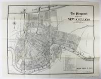
19062664New Orleans 1906. Very good. Sheet map 22 x 28 inches. Old folds. Minor soiling and wear. Scarce map of New Orleans issued by the Times Picayune. The map shows the city spread between Lake Pontchartrain to the north and the Mississippi River to the south with details of streets drainage railroads electric car lines and other points of interest. A numbered legend highlights various important locales such as the Picayune's offices City Hall different squares and parks the French Market and the railroad hubs. unknown
192141179Washington D.C.: Published by the United States Coast and Geodetic Survey 1921. Large folding nautical chart printed on heavy paper stock. Uncolored. A rare original coastal survey of Vermillion Parish including Vermilion Bay Marsh Island Pecan Island White Lake Cote Blanche Bay and Trinity Shoal.<br/> <br/> Established by President Thomas Jefferson in 1807 as the Survey of the Coast the U.S. Coast and Geodetic Survey was the United States' first civilian scientific agency. This agency has followed its mission to survey the U.S. coastline create nautical charts of the coast and help increase maritime safety since its founding and has often played fascinating roles in significant chapters of U.S. history. It served in all theaters of the Civil War in the service of the Union Army and Navy pioneered acoustic exploration in the wake of the sinking of the Titanic and during WWI it worked to detect enemy submarines. In addition this agency worked to survey and produce detailed maps and renderings of the U.S. coast. These nautical survey maps commonly referred to as "T-sheets" provide fascinating insights into the history of the United States coastline which has and will continue to shift. These maps are the most important data source for understanding the physical and ecological characteristics of the U.S. shoreline. The present map of the Louisiana coastline is notable for the inclusion of Marsh Island which was deeded to the state in 1920 the year this map was produced. It is a highly detailed and accurate sea chart of the Vermilion Parish and an important historical view of the developing Louisiana. Published by the United States Coast and Geodetic Survey unknown
182829714New Orleans: John Gibson- State Printer 1828. 211 1 blank; 199 1 blank pp. The 1827 Acts are bound in later cloth with morocco spine labels and an old law library gilt stamp at base of spine; bookplate on front pastedown; text lightly to moderately toned or foxed. Good. The 1828 Acts are bound in original attractive full calf with gilt-lettered morocco spine label. A couple of rubberstamps bookplate on front pastedown front and rear pastedowns worn. Good. <br /> <br /> English and French are on facing pages in each volume. The First Session passed acts prescribing the mode of private emancipation an act relative to runaway slaves the organization of the City of New Orleans into wards; establishment of a consolidated planters association of Louisiana; and various laws on internal improvements civil and criminal law. <br /> The Second Session repealed an Act which had prohibited entry of slaves into the State for purposes of sale and passed several statutes improving river and canal transportation incorporating "a society of Israelites" incorporating other associations like the New Orleans Jockey Club. Each Session includes an Index and Titles of Acts.<br /> Jumonville 600 625. AI 29537 3 33906 3. John Gibson- State Printer unknown
182829714New Orleans: John Gibson- State Printer 1828. 211 1 blank; 199 1 blank pp. The 1827 Acts are bound in later cloth with morocco spine labels and an old law library gilt stamp at base of spine; bookplate on front pastedown; text lightly to moderately toned or foxed. Good. The 1828 Acts are bound in original attractive full calf with gilt-lettered morocco spine label. A couple of rubberstamps bookplate on front pastedown front and rear pastedowns worn. Good. <br/><br/> English and French are on facing pages in each volume. The First Session passed acts prescribing the mode of private emancipation an act relative to runaway slaves the organization of the City of New Orleans into wards; establishment of a consolidated planters association of Louisiana; and various laws on internal improvements civil and criminal law. <br/> The Second Session repealed an Act which had prohibited entry of slaves into the State for purposes of sale and passed several statutes improving river and canal transportation incorporating "a society of Israelites" incorporating other associations like the New Orleans Jockey Club. Each Session includes an Index and Titles of Acts.<br/>Jumonville 600 625. AI 29537 3 33906 3. John Gibson- State Printer unknown books
1825WRCAM53386New-Orleans: M. Cruzat 1825. 241pp. Dbd. Moderate toning and foxing. Good. The official state publication of laws passed by the seventh legislature of Louisiana in its first session printed in English and French on facing pages. Only five copies located by OCLC at Yale Michigan Minnesota North Carolina and Historic New Orleans. JUMONVILLE 457. SHAW & SHOEMAKER 21249. M. Cruzat unknown books
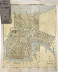
19081418New York 1908. Very good plus. Folding map 23 x 19 inches folded to 7.5 x 3.5 inches. Original grey printed card covers. Minor wear to covers a few small spots of foxing and wear to map. Handsome map of New Orleans printed in color with the canals railroads and electric street car lines highlighted. The map depicts the city from Lake Pontchartrain to the Mississippi showing minimal settlement south of the river primarily in the neighborhood of Algiers. Audubon Park Metairie Cemetery the city park and fair grounds are all highlighted as are many other smaller squares cemeteries and green spaces including the Oakland Driving Park today the New Orleans Country Club's golf course. At the time New Orleans was a city of about 300000 people. The present map shows that most of the neighborhoods along the Mississippi were traversed by "electric railways" with one line traveling north to the lake and terminating at West End while one line operated on the south side of the river. There are also numerous railroads delineated and several ferries crossing the river. A detailed look at the streets of New Orleans at the turn of the century. We locate fewer than ten copies in OCLC. unknown books
1812WRCAM40147Washington City 1812. 32pp. Dbd. Lightly foxed some chipping along spine- edge. Slight tanning to text. Good. The constitution of the State of Louisiana as accepted by the United States for entry into the Union. Louisiana's 1812 constitution was modeled after that of Kentucky providing for a two-house legislature and extensive executive powers. Only adult white males who paid taxes could vote which instantly disqualified two-thirds of the adult white male population and of course all nonwhites and women. The appeal for statehood was particularly urgent as the War of 1812 was unfolding. The Orleans Convention writes in January "Motives of peculiar urgency connected with the repose and security of the people of this territory have induced them to solicit of the executive that the constitution herewith transmitted may be immediately laid before Congress so as to be acted on without delay at their present session." Louisiana was the eighteenth state to enter the Union. SHAW & SHOEMAKER 27252. unknown books
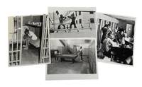
1973209341973. Archive of four press photographs produced between 1973 and 1976 documenting inmate life prison reform efforts and conditions within Orleans Parish Prison in New Orleans Louisiana a carceral institution whose origins extended back to the antebellum era and the policing of enslaved African Americans. The material documents systems of incarceration and institutional control through visual and textual evidence revealing recreational programs women's detention facilities inmate education initiatives and efforts to address violence within one of the nation's most criticized prison systems. Built in 1837 the prison historically functioned both as a municipal jail and as a site of punishment for enslaved people where imprisoned Black individuals could be subjected to whipping solitary confinement and deprivation. By the twentieth century the institution had become nationally associated with overcrowding violence and inmate abuse generating lawsuits and public scrutiny over prison conditions. These photographs provide primary-source evidence for the study of incarceration race prison reform and the lived experience of prisoners in the American South during the post-Civil Rights era.<br /> Archive consists of four black-and-white silver gelatin press photographs each approximately 8 x 10 inches many retaining original press captions or pasted articles on the verso or printed margins. One 1973 photograph depicts two Black inmates playing pool inside a sparse recreation area containing a single billiards table surrounded by concrete walls and rows of metal lockers illustrating the limited recreational infrastructure available to prisoners. A 1974 image captures two inmates identified as Perry Nelson and DeLyons boxing within an outdoor prison ring while correctional officers and inmates observe nearby; the accompanying article discusses prison efforts to channel inmate violence into organized athletic programming intended to improve morale and reduce assaults. A 1975 photograph shows a barefoot female inmate awaiting trial inside a dimly lit cell decorated with greeting cards small personal items and a cross placed on a shelf overhead while the accompanying article references public criticism and reforms intended to improve conditions for incarcerated women. Another photograph from the women's division dated circa 1976 documents female inmates and prison workers gathered in a classroom environment associated with "CONCEPT" a volunteer-led educational initiative established in 1973 offering counseling Black history courses creative writing sewing drawing music programs and lectures on topics including women's liberation and drug abuse.<br /> The archive reflects broader national debates surrounding incarceration and prison reform during the 1970s when increasing public attention focused on prison violence racial inequality within the criminal justice system and rehabilitation initiatives following the Attica uprising and other prison protests. Orleans Parish Prison became emblematic of deteriorating urban jail systems in the United States particularly regarding the treatment of poor and predominantly African American inmates. These photographs preserve both the punitive realities of the institution and the emergence of educational and rehabilitative efforts within the prison environment. Minor edge wear and occasional editor's markings. Very good condition overall. Historically significant visual record of incarceration race and reform efforts within one of the most notorious prison systems in the American South. unknown
In-8°; pp. 65, Due piccoli timbri a inchiostro al frontespizio. Resoconto delle attività delle missioni cattoliche in america del nord sotto il vescovo Du Bourg, la cui diocesi includeva l’Ohio, Mississippi, e le valli del Missouri. Du Bourg arrivò a Baltimora nel 1817 con un gruppo di preti e monache, e da lì viaggiò fino a Saint Louis. In quest’opera si riportano le attività svolte principalmente con gli Indiani. SABIN 55987
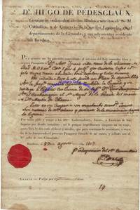
6238HUGO PEDESCLAUX 1751-1834. Pedesclaux served as consul of Spain at Bordeaux from 1796 to 1808. DS. 10 x 12. August 27 1803. Bordeaux. A partially printed document signed Juan Estrada in Spanish; the translation states: DON HUGO DE PDESCLAUX commanding Commissary for His Catholic Majestys Royal armies and the trade of the nation of Spain in the Department of Gironde and its vicinity residing at Bordeaux. Whereas I have deemed it beneficial to the Kings service to grant free and secure passage to Don Antonio Ignacio Silva a resident of Louisiana 32 years of age 5 feet 4 inches in height eyes brown eyebrows the same hair black nose bulbous mouth regular and complexion dark; the said individual arrived in this port with the rank of second officer on the Spanish merchant frigate named La Eugenia and is returning to Spain by leave of his Captain Don Luis Dauquemenil on the chasse-mare El Santo ngel de la Guarde Don Martn de Ybarra master; having as his companion a youth named Jacinto Len a native of New Orleans and arriving on the aforesaid frigate La Eugenia; I therefore pray and beseech the Lords Governors Judges and Peace Officers in the places through which he may travel to impose no obstruction to his journey but rather to afford him whatever favor and assistance he may require to continue. To this end I have granted the present passport signed by my hand and sealed with the Royal seal of this consulate. On the version the following is written in another hand in reply and signed Antonio Argote Villalobos: Having appeared with this passport at this Consulate of Spain in Virginia it is granted him to take passage to Louisiana on the vessel that suits him Norfolk 14 December 1803. This document is a passport for Don Antonio Ignacio Silva to enter the colony of Louisiana on the orders of Don Hugo de Pedesclaux the Spanish consul in French Bordeaux. It was issued during a time of great transition for Louisiana as it had just been purchased from France by the United States in the Louisiana Purchase. In return for fifteen million dollars about eighteen dollars per square mile the United States acquired 530000000 acres from France. Napoleon had hoped to re-establish a French colonial empire in North America as they had in the 18th century. France had only reacquired some of that territory the Louisiana Territory from Spain in 1800 having lost it in the Seven Years War in 1762 and explaining how a Spanish citizen like Silva could have lived there for so long. However France's failure to suppress a revolt in Saint-Domingue now Haiti plus the prospect of European warfare prompted Napoleon to sell off Frances North American possessions. Given that this document makes no mention of American control at either date and given how slow communication was in the early 19th century it is likely that none of the parties to this document knew of the Louisiana Purchase. In fact France would not turn over New Orleans their colonial capital until December 20 1803 after both signatures; and this was only three weeks after Spanish officials had belatedly formally turned over administration of the colony to France! The intertwined early 19th century histories of France and Spain would affect Pedesclaux. When Napoleon put his brother Joseph on the Spanish throne in 1808 Pedesclaux defected and swore loyalty to Joseph. He was not pardoned by Spain for this action until 1833. The document is in very good condition with some minor stains and folds. An English-language translation is included. unknown