2 675 résultats
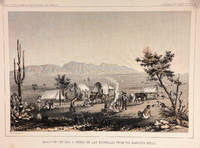
185714427Washington DC: Bevery Tucker Printer 1857. First Edition. Very Good. A.H Campbell. 8.25x11in One litho tinted illustrated plate Part I plate V; Light age-toning along edges with several light spots in margin. Samuels p. 81 Taft p. 265. This plate is from from Volume VII of the quarto edition of twelve volumes were published from 1855 to 1861 as exploration and survey reports became available. These volumes contained not only the survey maps and elevations but a monumental collection of scientific reports on geography geology zoology botany and ethnology of the Native American tribes. The surveys also included 11 artists to record the landscape and indigenous peoples of the west. <br /> <br /> <br /> <br /> Albert Henry Campbell 1826-1899 was a Railway survey artist-explorer civil engineer and surveyor. He was one of the more important artist of the surveys and participated in several survey expeditions across the west from 1853 to 1854. In the fall of 1854 he joined the Parke survey expedition for a coastal railroad route from San Francisco to San Diego and the survey along the 32nd parallel to Arizona. All eight of the full-page illustrations are credited to Campbell in the report three of California and five of Arizona scenes After the surveys he was assigned to Washington as Superintendent of Pacific wagon roads to 1860. During the Civil war he was a map maker for the Confederate Army and chief engineer of railroads based in West Virginia. from Samuels <br /> <br /> The twelve volumes were disorganized in publication with no overall all arrangement or indexing. Some of the plates and maps referred to in volumes were published in other volumes various reports were also published out of sequence relating to the four routes. Preliminary reports published were updated in latter volumes. From Wagner-Becker-Camp In 1853 Senator Gwin of California lead the inclusion of Congressional funding for 1853-54 of a series of surveys to determine the best and most economical railroad routes from the Mississippi River to the Pacific coast. The act directed the Secretary of War Jefferson Davis to plan and direct Army topographical engineers to conduct surveys of four routes. The first was between the 47th and 49th parallels generally along the Lewis and Clark route to the Pacific. The Second route between the 37th and 39th parallels was promoted by Senator Thomas Hart Benton of Missouri. The Third route was along the 35th parallel. The Fourth route was promoted by Secretary Davis along the 32nd parallel that followed Emory's 1846-47 reconnaissance. Bevery Tucker, Printer unknown
15-4983North Hollywood CA: Poets Of the Pacific 1954. 32mo. 5 pp. Postcard Envelope Brochures Very Good with some fading creasing and shelf wear. North Hollywood, CA: Poets Of the Pacific, 1954. unknown
69-4220Los Angeles California: Security Pacific Corporation 1987. 4to. Softcover. 52 pp. Color Plates. Good slight tear on binding.Provenance: Berkeley Architectural Historical Association Los Angeles, California: Security Pacific Corporation, 1987 paperback
75-6308Los Angeles: Pacific Design Center for Contemporary Culture 1980. 4to. Soft Cover ca. 150 pp. B&W and Color Plates. Very Good with CreasingAge Toning Sunning minor Abrasions and Minor Tearing Ex-Library.Provenance: From the library of the San Francisco Gallerist Pasquale Iannetti. Los Angeles: Pacific Design Center for Contemporary Culture, 1980 paperback
15-6914Anchorage: Alaska Pacific University 1979. POSTER. 4to. 7 x 9 inches Very Good some minor creasing. Photograph of Snyder. Anchorage: Alaska Pacific University, 1979. unknown
1986000892Southern Pacific 1986. VG. Very good plus hard cover. No dust jacket. Includes cover letter dated September 1 1988. Boards are clean and bright. Binding is excellent. Pages are clean and unmarked. Carefully wrapped and packaged in a padded box for safe shipping. . Hard Cover. Very Good . Southern Pacific Hardcover
01-0070San Francisco Calif.: Southern Pacific Railroad November 1931. Map. Blueprint. 8 x 26 inches. Scale 1 inch = 1000 feet. San Francisco, Calif.: Southern Pacific Railroad, November, 1931. unknown
19176139New Orleans: General Passenger Department Southern Pacific Lines 1917. Good. 105 x 235 mm. 32 pages in stapled wraps embossed with a medallion portrait of Bienville and printed in bronze. Text pages with green tinted borders and green tinted overlay illustrations. Each page with black and white half-tone photo illustration and text. Railroad map of the United States on inside back panel. Sun marks on front panel of wraps. A little dusty but unmarred. <br /><br /> General Passenger Department, Southern Pacific Lines paperback
15-8427San Francisco CA: 1885. Print of Ink Drawing 18 x 24 cm. Mounted on Archival Laid Paper Inside Mylar Folder Near Fine. Rendering of San Francisco's main train station rebuilt in 1914 for the Panama-Pacific Exposition held in 1915 then demolished and moved in 1971. San Francisco, CA: 1885 unknown
10-0096Omaha Neb.: Union Pacific Railroad 1923. Railway pass. Single card 2.5 x 4". Typewritten to various Union Pacific System employees. Valid 1923. W/ stamped signature of Pres. of SP. Signed in ink on verso by holder. Rare. Omaha, Neb.: Union Pacific Railroad, 1923. unknown
10-0100Omaha Neb.: Union Pacific Railroad 1923. Railway pass. Single card 2.5 x 4". Typewritten to various Union Pacific System employees. Valid 1923. W/ stamped signature of Pres. of SP. Signed in ink on verso by holder. Rare. Omaha, Neb.: Union Pacific Railroad, 1923. unknown
1987055924Salt Lake City UT: Howe Brothers 1987. 1st . Hardcover. Fine/Near Fine. 4to - over 9¾" - 12" tall. 305pp.incl.index; HB burgundy w/gilt; fine condition w/cleantight pgs. DJ blk.&white photo w/white; slight rub w/spiine&edges sunned. ".the 1889 expeditions' motivation adds an air of fantasy to what actually was a very practical enterprise-proving the feasibility of building a low-grade railroad alongside the Colorado all the way to the ocean." b/w photos. <br/> <br/> Howe Brothers hardcover
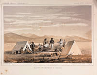
186014426Washington DC: Thomas H. Ford Printer 1860. First Edition. Very Good. 8.25x11in One litho tinted illustrated plate Part I plate XXXII; Some age-toning along edges with several light spots in margin and print. Samuels p.460 Taft p. 1. This plate is from from Volume XII of the quarto edition of twelve volumes were published from 1855 to 1861 as exploration and survey reports became available. These volumes contained not only the survey maps and elevations but a monumental collection of scientific reports on geography geology zoology botany and ethnology of the Native American tribes. The surveys also included 11 artists to record the landscape and indigenous peoples of the west. The twelve volumes were disorganized in publication with no overall all arrangement or indexing. Some of the plates and maps referred to in volumes were published in other volumes various reports were also published out of sequence relating to the four routes. Preliminary reports published were updated in latter volumes. From Wagner-Becker-Camp In 1853 Senator Gwin of California lead the inclusion of Congressional funding for 1853-54 of a series of surveys to determine the best and most economical railroad routes from the Mississippi River to the Pacific coast. The act directed the Secretary of War Jefferson Davis to plan and direct Army topographical engineers to conduct surveys of four routes. The first was between the 47th and 49th parallels generally along the Lewis and Clark route to the Pacific. The Second route between the 37th and 39th parallels was promoted by Senator Thomas Hart Benton of Missouri. The Third route was along the 35th parallel. The Fourth route was promoted by Secretary Davis along the 32nd parallel that followed Emory's 1846-47 reconnaissance.<br /> <br /> The illustration "Awaiting the Return of Mr. Tinkham" was done to support part of the report narrative by Stevens starting on p. 127 of the report. Mr. Tinkham was one of several civilian members of the survey that fanned out along the general route to identify better terrain for a railroad line. They were generally accompanied by Native American guides the knew the terrain. Mr. Tinkham proceed without a guide and became disoriented for a number of days before finding his way back to the camp. <br /> <br /> John Mix Stanley 1814-1872 was an artist-explorer American painter of landscapes and of Native American portraits and tribal life. In 1842 he traveled to the West to paint Native Americans and spend the next ten years painting and exhibiting in eastern cities and the Smithsonian. During the Mexican War in 1846 he was a draftsman for the Corps of Engineers assigned to Colonel Kearney's expedition to California and Oregon Territory. He produced maps and illustrations for the Army. After the war he spent time in Hawaii painting the Royal family native life and landscapes. In 1853 Stanley was appointed the chief artist to Isaac Stevens survey expedition for a Pacific railroad route from St. Paul to Puget Sound the Northern Survey. During the survey he produced the stunning 70 illustrations and fold out panoramas in the Stevens report. When he returned to Washington in 1854 he produced an exhibition of his paintings and large panoramas of western scenes from the Northern survey. from Wiki and Samuels in part. Thomas H. Ford, Printer unknown
63-9583Paris: Sud Pacific Films 1963. B&W Photo 18 x 13 cm. Very Good. Stamped on verso. Paris: Sud Pacific Films, 1963. unknown
1966066903Australian National Advisory Committee for Unesco 1966. Soft cover. Very Good. Large softcover in VG condition: unmarked slight wear slight corner bumps. 95 pages. 7oz <br/> <br/> Australian National Advisory Committee for Unesco paperback
59-3319San Francisco Calif.: State of California 1876. Stockholder lawsuit against the Central Pacific Railroad by Anthony Egl et al. seeking payment of bonds. Suit names Leland Standord C. P. Huntington and Mark Hopkins as owners of the railroad. From the Bancroft Library of the University of California. Pamphlet bound in taped boards. Original pamphlet pasted in printed wrapper. 6 x 9 inches. Library bookplate and stamp.Very Good condition. San Francisco, Calif.: State of California, 1876. hardcover
194525602The Pacific Telephone and Telegraph Co. Very Good with No dust jacket as issued. 1945. First Edition. Softcover. Light rubbing and creasing. ; 8vo 8" - 9" tall; 1763915 pages . The Pacific Telephone and Telegraph Co. paperback
192218889Portland Oregon: The Pacific Telephone and Telegraph Co. Very Good. 1922. First Edition. Softcover. Light stain and note on the front cover "please hang up this book" . ; 4to 11" - 13" tall; 112 pages . The Pacific Telephone and Telegraph Co. paperback
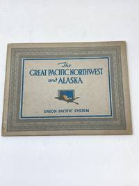
191588711Chicago IL: Newman-Monroe Company 1915. Staplebound Pamphlet. Very Good Plus. Oblong stapled pamphlet 8 in. x 6 1/2 in. printed on beautiful grey cardstock with lovely blue green and orange embossed graphic and lettering to front panel.47 pp. 33 of which are photographs with detailed captions. of rivers lakes mountain peaks canyons valleys gorges and cities from Seattle up through Alaska. Newman-Monroe Company unknown
192018586Union Pacific System. Good. 1920. First Edition. Hardcover. The book begins at page 3. However I am not sure a page is missing as page 3 is blank with a dated note tipped onto it signed in facsimile by the general manager. Either way priced as is. Rubbing at the corners and separating at the rear hinge ~2" . ; 16mo 6" - 7" tall; 135 pages . Union Pacific System hardcover
198060189Washington DC: U.S. Government Printing Office 1980. Wraps. Good. No dust jacket. Has some wear and soiling. Some edge soiling. iv 335 p.; 24 cm. Occasional footnotes. This hearing focussed on the human rights situation of Taiwan South Korea the Philippines and Indonesia. U.S. Government Printing Office paperback
68-7128Berkeley CA: UC Berkeley 1992. Exhibition Catalogue. 4to. Soft Covers. 48 pp.Mostly Color Plates. Very Good. Provenance: Suzaan Boettger. Berkeley, CA: UC Berkeley, 1992. paperback
200047987Washington DC: GPO 2000. First Edition. First Printing. very good. 139 wraps. Joint hearing with the Subcommittee on East Asian and Pacific Affairs of the Senate Committee on Foreign Relations. Serial No. 106-98. GPO paperback
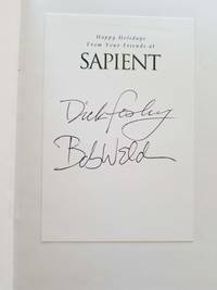
20182055New York: Skyhorse Publishing 2018. Second printing. Hardcover. Good/very good. Signed without inscription by Dick Foasbury and Bob Welch on a corporate Sapient holiday book plate affixed to the front free endpaper. Black hardcover with silver spine titles 2nd printing in dustjacket. A good only copy with wear to the spine tips bumping to the lower board corners and some dots of brown to the bottom of the front board. Interior is clean and unmarked other than the ghost of a previous bookstore price erased at the top of the ffep. The book opens widely at the half title page but the binding is solid as are the hinges. The unclipped jacket is much better - clean and bright with minimal edgewear. 282 pp. indexed black and white photo gathering at the center. Fosbury's passing in early 2023 was a blow to the track and field community in Oregon where he pioneered the Fosbury Flop - used by most competitors in the high jump to this day. <br/><br/> Skyhorse Publishing hardcover
010718San Francisco California. Photo Gravure Company. Western Pacific Railway Company. n.d. but ca. 1925. Octavo 8 x 12. 8 pp. Scenic photos of the canyon captured from the railroad side Highway 70 wasnt completed until 1936 showing the north fork of the Feather River including shots of Arch Rock and other scenic locations. Tragically now much of the forest in the canyon has been destroyed by the Dixie fire of 2021. The booklet is bound in cream and green wrappers with green titles. Light wear and mild splits at the folds otherwise very good. unknown