DUMONT D'URVILLE (Jules-Sébastien-César).Livre Rare Book
6 262 résultats
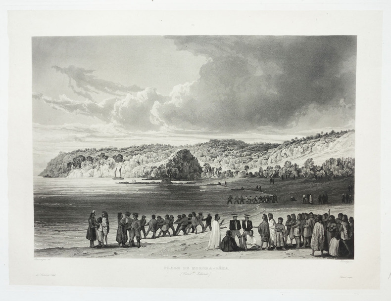
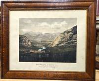
1833LBW-5457[Paris, 1833]. 581 x 429 mm.
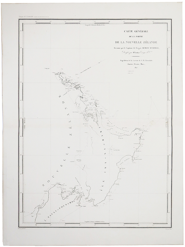
1833LBW-1980Paris, 1833-1839. 275 x 371 mm.
18174234Paris, Gide Fils and Nicolle, November 1817. 1817 2 vol. in-8° (250 x 125 mm) de : 398 pp. (dont les xxii pp. du début), [1] ff.; 398 pp. Demi-veau d'époque, dos lisse orné, plats recouverts de papier à la colle bleu, tranches jaspées. (Reliure et corps d'ouvrage très frais).
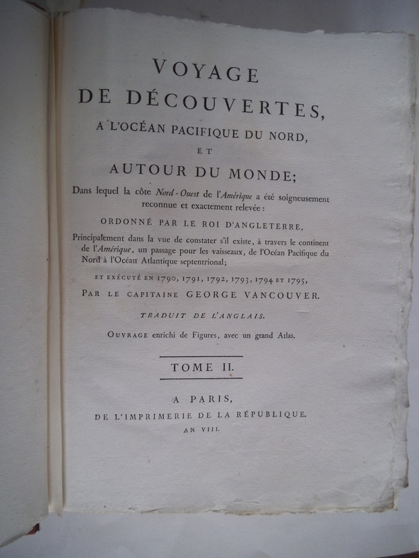
1800PHO-2418Paris, Imprimerie de la République, an VIII (1800). 3 vol. in-4 (28,5 × 21 cm), XII-491pp., 2ff.-516pp., 3ff.-562pp., demi-veau fauve à petits coins de vélin, dos lisses teintés vert et ornés de bateaux (reliure de l’époque). Charnières fendillées, accrocs à deux coiffes. Infimes rousseurs, petites déchirures sans gravité. Tome I, quelques cahiers brunis, 1 feuillet fragile.
104239De l'Imprimerie Didot Jeune, An X (1801-1802), 5 volumes +1atlas in-8 de 220x140 mm environ, viij-341 pages - 384 pp., - 381 pp., - 368 pp.,- 438 pp., dernier volume-atlas contenant 17 vues sous serpentes et 9 cartes dont 8 dépliantes, cartonnage de l'éditeur portant titres et tomaisons dorés sur le dos. Feuillets non rognés. Dos insolés, frottements sur les coins et coiffes, petits défauts de marge sur quelques pages sans atteinte au texte, sinon bon état.
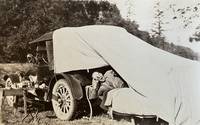
188059310Portland OR & Seattle WA: Walter Angus MacKay Julia Rose Eder MacKay Cross & Dimmitt ca. 1880-1958. Two vols. 1st - Thick oblong 4to. 11.5 x 8.75 x 2.25 in. 128 pp unpaginated. on thick black paper. With 461 photographs sized 1.75 x 2.75 in. up to 4.5 x 5.5 in. including 2 CDV’s 1 cyanotype several albumen and range of silver gelatin snapshots on matted and glossy paper stock many w/ annotations either on verso below images or w/in the margins at lower fore-edge or in pencil some w/ white ink alongside the images. Contemporary flexible polished calf post-binder punch-sewn at gutter margin in gold silk braid RPPC of Tillamook Bay OR by Gregg mounted on front cover chipping & wear to front cover wear to corners wear & rubbing to some fore-edges occasional chipping minor closed tears still VG exemplar; 2nd vol. -- Oblong 8vo. 8 x 5.75 in. 78 pp unpaginated. on thick tan paper stock. With 101 silver gelatin photographs mounted sized from 1.75 x 2.75 in. up to 4 x 6 in. some w/ sepia effect either mounted directly on the pages or many affixed with small strips of black paper or old paper corners affixing the images to the leaves a few w/ annotations on verso or below. Contemporary flexible diced calf “Housh†photo album chipping & wear to spine wear & bumping to corners some pages reworked by compilers at some point still a G exemplar both albums’ photos with bright strong contrast. These photo albums faithfully follow the sporting and leisure activities of two gearheads from Chicago -- Walter MacKay and his brother Carrol MacKay who together with their extended families and friends drive and auto-camp across the West. The large first album opens with many photos following a trip to Yosemite National Park as well as scenes along the route and upon the return of Walter & Julia. Their follow-up automobile trip in 1928 takes them to Yellowstone National Park via Spokane Idaho and Montana with photos included of Old Faithful a photo by Haynes of the Grand Geyser as well as auto camping at “Mammoth Hot Springs.†Subsequent photos trace their travels through the Columbia River Gorge the Snake River Mount Rainier National Park Ariel Dam near Ariel WA Hoods Canal WA and Newport OR. Their speed boat launch the Carmen is featured in some photos along with several views of pumps hoisting engines giant diesel and gas engines under repair. Other trips include those to Snoqualmie Falls Trout Lake WA near Mt. Adams working a hoist at logging camp partying with friends in Renton WA and even views of Walter MacKay advertising his Automobile Repair Shop with a cover on his rear tire. Other outings include auto camping and picnicking along the Mt. Hood Loop Grant’s Park on the Clackamas River Mt. Hood the Rogue River Table Mountain and views of Grants Pass. Walter and his gearhead friends were known for their stripped-down roadster racing cars and were also early participants in the Seattle Motorcycle Club and Motorcycle races. A couple photos within the two albums show early motorcycles and even gallivanting on some stripped down chassis without engines or tires. The second album includes a series of photos featuring Walter and his car beneath a towering Cedar Stump with arch cut into the base and him holding gun as well as standing on the fenders of the car. The second also includes automobile camping photos with tent and cots folded out of the rear of the automobile driving into Vancouver B.C. as well as driving to Mount Rainier and more along the Columbia River Highway and Mount Hood. Also featured are hunting shots in Eastern Oregon construction of a summer log cabin and much more. Mackay 1883-1959 was a mechanical engineer machinist gearhead racecar builder who came West working for the railroad as a machinist before working for Paragon Co. in Seattle as parts manager. He owned and operated the MacKay Automotive Repair at 165 E. 39th in Portland OR on the SW corner of 39th Cesar Chavez and Belmont for years before working at Albina Engine & Machine Works at the end of the Great Depression. One of the photos in the 2nd album shows MacKay with his camera shooting a photo and several show Julia MacKay’s 1880-1958 sisters and family. Should be noted we unknowingly catalogued an album on Seattle Auto Racing and Motorcycle Clubs from before World War I without having had access to these unknown albums. See: The Origins and Growth of the Club Scene in Western Washington 1910-1941 Jolly Rogers Motorcycle Club Feb. 7 2009; Seattle Motorcycle Races Pantages Theater Program Early Advertising in the West 1867-1918 Univ. of Washington Spec. Collections. Walter Angus MacKay, Julia Rose Eder MacKay, Cross & Dimmitt, unknown
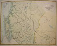
1874M7548Montreal: Canadian Pacific Railway 1874. Very Good; laid down on acid-free tissue paper for long-term preservation. Notes: A very important and early working map of Alberta and British Columbia depicting existing and suggested railways.<br>There is a note written in period ink in the lower margin in reference to a contemporary marking of newly suggested routes in black ink:<br><br>"Note -- The Surveys made since the publication of the Report & Maps of 1874 shew the routes colored full black line and thus broken black line to be the best lines for railway construction that have been found to this date Oct 1875. Mr. Smith".<br><br>"Mr. Smith" is believed to be Donald A. Smith a major partner in the yet-to-be incorporated Canadian Pacific Railway Company in 1881. <br><br>The routes marked out in red as printed depict potential lines crossing the Rockies to the west of Edmonton at Yellowhead Pass. Almost none of the suggested routes depicted on this map were eventually used--CPR dismissed the use of Yellowhead Pass for a pass farther south in order to discourage competition from railway lines south of the border. They chose instead Kicking Horse Pass which is depicted on this map. Size : 608x779 mm 23.94x30.67 Inches Coloring: Hand Colored Category: Maps Railroad; Maps Canada West British Columbia;Maps Canada West Alberta; Canadian Pacific Railway unknown
1868WRCAM33573Washington 1868. 39pp. plus large color folding map. Modern maroon cloth gilt maroon morocco label. Minor dust soiling in text. Map bright and clean. Overall very good. An application to Congress by the Northern Pacific Railroad headed by Minnesota railroad magnate James J. Hill for federal aid to support the Railroad's expansion to the West Coast. The petition reviews the railroad's original charter and includes an impressive color folding map "Map of the Country from Lake Superior to the Pacific Ocean" which illustrates the railroad's route from Duluth to Seattle and Portland. This map was originally produced to accompany Edwin Johnson's report on the feasibility of the railroad. This is one of the finest maps of the region traversed to be issued up to this time and was produced by Colton in New York not by the government. Wheat devotes several pages to discussing it noting that "the detail of such a map defies cataloging." Above the map appears an elevation chart for the same distance. <br> <br> A fine account of railroad expansion in the Northwest. Rare. Not on OCLC. MIDLAND NOTES 68-164. WHEAT TRANSMISSISSIPPI 1169. hardcover books
In-8 gr. (mm. 256x192), p. vitellino coevo (con aloni, restauro a una cerniera per spacco), dorso a cordoni con decoraz. e tit. oro su tassello, tagli rossi, pp. (4),XXII,314, con 4 carte geografiche, inc. in rame e più volte ripieg. (carte générale de l’Empire Russe - Voyage de Krenitzin et de Levasheff aux Isles des Renards, en 1768 et 1769 - Carte du voyage de Synd vers les Parages de Tschukotikoi: partie Nord Est de la Sibérie - Carte du voyage de Shalaurof: Mer Glaciale) e 1 bellissima grande tavola (più volte ripieg.) con la veduta di “Maimatschin ville frontière chinoise et du ruisseau de Kiachta, prise de l’Ouest”, pure inc. in rame. "Prima edizione della versione francese". Cfr. Brunet,II,399 - The Hill Collection of Pacific Voyages,391 per la prima ediz. inglese del 1780: “The Reverend William Coxe was an English historian who traveled widely in Europe and Russia.. Coxe recounts (from 1745 on) the principal Russian discoveries and explorations made in northwestern America in their attempts to open communications with Alaska and the Aleutia Islands. The voyages and discoveries of Nevodsikoff, Serebranikoff, Trapesnikoff, Drusinin, Korovin, Glottoff, Solovioff, Krenitzin, Levasheff, Synd, Bering, Shalauroff, and several others are included.. Coxe made suggestions which led the Russians to promote expeditions of discovery to the northern parts of Siberia. Notable in the present work are a useful bibliography and pertinent observations on the fur trade between the Russians and the Chinese”. Lievi arross. o aloni al margine esterno bianco, ma buon esemplare.
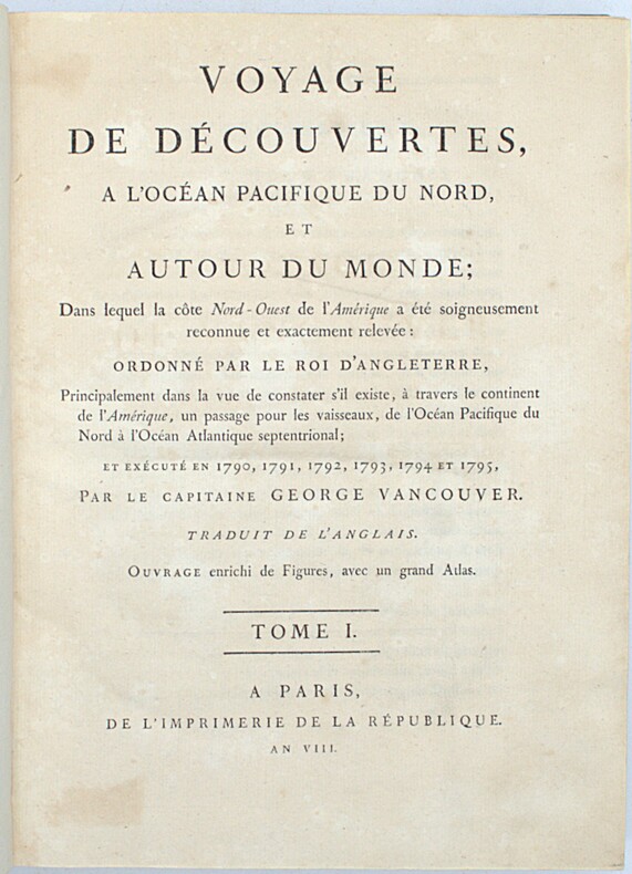
8186dans le quel la côte Nord-ouest de l’Amérique a été soigneusement reconnue et relevée ordonnée par le Roi d’Angleterre, principalement dans la vue de constater s’il existe,à travers le continent de l’Amérique,un passage pour les vaisseaux,de l’Océan pacifique du nord à l’Océan atlantique septentrional et exécuté en 1790,1791,1792,1793 par le capitaine George VANCOUVER traduit de l’anglais. Ouvrage enrichi de figures.Trois tomes en trois volumes petit in folio,reliure cartonnée, postérieure,avec étiquette de titre imprimée.Tome premier:faux-titre,titre, XII,491 pages 7 gravures hors-texte sous serpente.I) village indien désert II)4 mâts singuliers fichés en terre III) Mont Rainier IV) village d’une tribu d’indiens V) village de Cheslakées VI) la découverte VII) Anse des amis. Tome second : faux-titre titre 516 pages 5 planches hors-texte sous serpente petites déchirures réparées en marge inférieure de la table des matières. Planche I) La mission Carlos près de Monterey II) cartes des iles d’Hergest, III) Anse des Saumons, dans l’entrée de l’observatoire. IV) New-Eddystone, dans le canal de Behm. V) le Présidio de Monterey Tome troisième : faux-titre, titre 562 pages, une déchirure réparée à la dernière page de la table des matières ainsi qu’à la page de garde. 5 planches hors-texte sous serpente planche I) cratère d’un volcan au sommet du Mont Worroway dans l’ile d’Owhyhée. II) Port Dick pris à l’entrée de Cook avec une flotille de pirogues indiennes III) Le mont saint Elie IV) Montagne remarquable près de la rivière de Monterey VI) le village d’Almandrel dans la baie de Valparaiso.La vue de Valparaiso,annoncée,n’était pas jointe à ce volume.Grandes marges.Sans l'atlas.Edition originale de la traduction française. A Paris de l’Imprimerie de la République An VIII
18821204Portland Or: George H. Himes 1882. About very good. 328pp. plus photograph frontispiece. Original printed wrappers. Spine ends chipped; some light dust soiling and wear to wraps. Slight fading to frontispiece photo but a clear image. Light even tanning internally; three leaves with small patches of damp staining. A scarce 1882 promotional for potential excursions from Portland Oregon published in conjunction by the Northern Pacific Railroad and the Oregon Railway & Navigation Company. The work is illustrated with a real photograph of the Multnomah Falls east of the city on the Columbia River. The text prints itineraries for ten trips from Portland in the Pacific Northwest to the Cascades the Dalles Seattle Tacoma Olympia Ilwaco and even Alaska almost all via the steamers of the Oregon Railway & Navigation Company. The final four leaves of text contain numerous illustrated advertisements for Portland businesses. The frontispiece photograph of the Multnomah Falls is credited in print to Issac Grundy Davidson. "One of the Northwest's premier photographers Davidson published an extensive series of scenic photographs covering many aspects of life and scenes throughout Oregon Washington and Alaska. He operated portrait studios a traveling gallery and contracted with the Northern Pacific Railroad. A keen businessman who produced the finest photographic record of Oregon during the 1870s-80s" - Mautz. An excellent example of the collaboration between a pre-eminent photographer of the Pacific Northwest and the Northern Pacific Railroad as well as an unusual and scarce specimen of a rail and river travel promotional illustrated with a real photographic print. George H. Himes unknown books
1851PACIFICO015869Longman Brown Green and Longmans London. 1851. First edition. Octavo. Two volumes in one: pp xii 352; xii 371. Four chromolithograph plates. Original blue cloth decorated in blind lettered in gilt.On the front free endpaper are two 19th century inscriptions one of which has been crossed through. Some foxing here and there. Head and tail of spine a bit scuffed. Some wear to edges. Very good. Very scarce in the intact publishers' binding. Longman, Brown, Green, and Longmans, London. hardcover
9211196345New. Brand new and still unused unknown
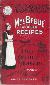
190010228San Francisco; Chicago: Southern Pacific Railroad; Printed by Poole Bros 1900. Duodecimo-size booklet 14.75 x 8.5 cm. 80 pages. Blue and brown ink on pink paper. Two photographic portraits Monsieur and Madame Bégué. Illustrations. List of railway agents. Title from cover. In logo at head of title: Southern Pacific Sunset Route. ~ Evident FIRST EDITION. A souvenir anthology of writings including sixty recipes from two landmark New Orleans restaurants offered for sale to customers traveling the Sunset Route San Francisco–New Orleans by the Southern Pacific Railroad Company. A sampling: Mutton Feet à la Créole Liver à la Bégué Jambalaya of Chicken Codish with White Beans Bisque of Crayfish Creamed Cauliflower Onion Salad Eggplant with Rice and Ham Mayonaise of Celery and Shrimps Pineapple with White Wine. ~ The title displayed on the wrappers is misleading: the atmospheric essays and testimonials – arranged by a literary journalist who contributed to Southern Pacific's promotional magazine Sunset Henry Monroe Mayo 1868-1950 – reveal little regarding the eponymous originator of the recipes or the history of the cuisine that brought her fame. Only pages 47-68 contain recipes by Elizabeth née Elisabetha Kettenring Dutreuil Bégué 1831-1906 the proprietary chef of the beloved restaurant in the Vieux Carré – the second oldest such establishment in New Orleans – located on the Rue de la Levée Decatur Street after 1870 downriver from Jackson Square and across from the French Market. An immigrant from southern Germany she had opened a coffee shop with her husband Louis Dutreuil in 1863. After his death in 1875 she married again and with her second husband Hippolyte Bégué 1842-1917 reopened in the same location with the aim of serving one meal per day – a “second breakfast†beginning at 11:00 a.m. – to accommodate laborers in the meat markets and on the docks who started work at dawn. A fuller history by David Shields is available in his The Culinarians Chicago: University or Chicago Press 2017 pages 270-273. By the mid-1880s trade fairs held in the city were bringing tourists as well and Bégué’s became a destination on its own. Madame Bégué died in 1906. The restaurant continued under management of her daughter but was sold in 1914 to relatives of the family Tujague competitors since 1856 on Decatur Street a few doors away. ~ A shorter tribute with recipes pages 69-74 is accorded another restaurateur presumably Victor Béro d. 1904 an immigrant from Belgium who had presided over Victor's Restaurant since 1873. Mayo appears to confuse the "Monsieur Victor" of his time with the founder and namesake of the establishment Victor Martin 1812-1865; cf. Shields page 136 445. ~ The Sunset Route of the Southern Pacific Company was the southernmost of the transport lines to the West Coast originally contemplated by the series of Pacific Railroad Acts between 1862 and 1866. Of the resulting publicly subsidized corporate consortia that would transform western North America – known collectively as the transcontinental railroads – Southern Pacific was already a mammoth system in 1900 including smaller subsidiaries such as the Texas and New Orleans Railroad and extending across territories that would later become New Mexico and Arizona as well as northwards through Nevada Utah and much of California. The in-house Sunset magazine appears to have been printed close to headquarters in San Francisco but like many publications issued by the transportation industry Mme. Bégué and Her Recipes was printed by Poole Brothers of Chicago who advertised as "railway printers" and also produced tickets brochures and mileage tables. ~ Internally clean and sound; in publisher's red wrappers decorated in black and white with an image of Madame Chef in kitchen apron. Wrappers with some rubbing and two small chips to the spine Near very good. Rare. OCLC locates thirteen copies; Uhler 28; New Orleans Culinary History Group page 13; not in Bitting Brown or Cagle. Southern Pacific Railroad]; [Printed by] Poole Bros unknown
1900P5495Canada: Canadian Pacific Railway c.1900. Very Good . Notes: View of Banff Springs Hotel and Bow River Valley National Park-Rocky Mountains. It is framed in its original frame. <br>The Fairmont Banff Springs formerly and commonly known as the Banff Springs Hotel is a historic hotel in western Canada located in Banff Alberta. Image Size : 404x528 mm 15.91x20.79 Inches Platemark Size : Paper Size : 550x692 mm 21.65x27.24 Inches Coloring: Hand Colored Medium: Offset Lithograph Categories: Views Canada Alberta & British Columbia; Canadian Pacific Railway unknown
187044035Omaha: Land Department Union Pacific Railroad Company 1870. 1870. First edition. First edition. 8vo. 8 3/4" x 5 3/4" printed wrappers with map on back cover 44 pp. introduction illustrated maps. The rear cover features a map of portions of Idaho Utah Wyoming Colorado Dakota Nebraska Kansas Missouri and Iowa. States where land grant bonds are available from the Union Pacific Railroad Company. The frontispiece is a map of the United States that shows the Union Pacific Railroad and its connections. A third map shows counties in Nebraska in 1870 and the Union Pacific Railroad lands first 200 miles grants of 1862-64. A description of the Nebraska lands are provided county by county. The available lands are contained in alternate sections of one square mile each within a breadth of twenty miles on either side of the railroad and extend along the entire line. They extend through central Nebraska southern Wyoming and northern Colorado and Utah and include within their limits the splendid agricultural lands of the Platte Valley the great natural pastures of the Laramie Plains and the valleys of Lodge Pole Creek and Bear River and the rich iron and coal fields between the Black Hills and the Wahsatch Mountains. Description advantages water resources climate soil live stock raising farming markets timber minerals information about homesteads advantages of living in colonies etc. Both Adams' Herd and Graff list similar titles but different years and claim their listings to be "rare." A small bump to the top edges light wear to the spine ends else a near fine copy. Land Department Union Pacific Railroad Company, 1870. unknown
20069924San Francisco CA: Pacific Editions 2006. One of 38 copies all on BFK Rives and Strathmore papers incorporating hand-colored cotton and jute twine each signed and numbered by the two poets and artist / designer Charles Hobson who assembled the edition with the assistance of Alice Shaw. Page size: 7-1/2 x 8 inches; 48pp. Bound: two signatures sewn in an accordion structure fabric and paper over boards red printed label on spine; housed in fabric-covered slipcase with red jute twine ties. The design of the book incorporates twine which actually weaves through the text. Inspired by the poem and evoking the experience explored in the text the string / thread acts like a drawn line and can be moved around by the reader to change the "drawing" and the experience. The reverse folds of the book contain images of beets to accentuate characteristics of the poem. The string-like roots and the fullness and ripeness of the vegetable shapes recall and emphasize the individual words from the poem that the artist has chosen to reprint with the images: voice awaken heart distance breath birth. <br/>The poets Paula Sager and Lizbeth Hamlin are practioners and teachers of Authentic Movement a practice that is concerned with the exploration of relationship. In its simplest form there is a mover and a witness. The mover with eyes closed waits for an impulse to move. The witness follows or tracks his or her own experience while being present and attentive to the mover. Their poem is rhythmic and flowing an exploration of insight discovery and personal revelation which is aimed at showing how we as human beings long to relate.<br/>Charles Hobson created the images and reproduced them in hand-colored high resolution digital prints. The text was set by Mr. Hobson in Cantoria MT Light following the authors' original spacing and printed offset. Each page is a visual delight with the text weaving swooping and dipping around the red cotton and jute twine sometimes under the threads with the ensuing shadows but always carrying forward the theme of connectedness. The reader is propelled forward following the motion of the words with the implicit motion of the "thread" of the book. Once again Charles Hobson has taken text and conceived of and created a structure that embodies that text. The reader / viewer is the richer for it. We are presented with a concept and it is explored in the text and then again in the book's structure. And the beets / beats . ! They are the organic imagery that not only move the eye forward but hold the eye with pleasure for at least a beat or two. One could dance to this book and I suspect that was the intent of authors and artist. Pacific Editions unknown books
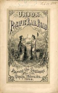
186854323New York: Published by the Company 1868. 1868. TRANSCONTINENTAL RAILROAD. First edition. Pamphlet edition. 8vo. Pictorial wrappers 40 pp. frontispiece Map of the Union Pacific Rail Road and its Connections introduction illustrated frontispiece map advertisement on rear cover for "First Mortgage Bonds at 102 principal and interest payable in gold with an annual income of "between eight and nine percent." This is an investment and advertising booklet for the first transcontinental railroad in the United States which was built by the Union Pacific Railroad and the Central Pacific Railroad in order to connect the Atlantic and Pacific coasts by rail for the first time. Begun in July of 1865 and built primarily by Civil War veterans the construction and completion of the Union Pacific line was one of the most significant technological and economic accomplishments of the 19th century creating the vital connection for commerce trade and travel and literally joining the eastern and western halves of the United States. Contents include the formation of the Union Pacific Railroad Company progress natural resources construction branch and connecting roads construction resources anticipated business & profits actual earnings and sale of first mortgage bonds. A list of officers of the company is provided. Top of front cover displays that this copy is mildly ex-library with stamp and number appearing at the upper right side a faint vertical fold to the center of the booklet tiny chips to bottom corner of front cover and a few preliminary pages. Overall a very good copy of an important railroad report. Published by the Company, 1868. unknown
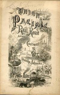
186754322New York: Brown & Hewitt Printers 1867. 1867. TRANSCONTINENTAL RAILROAD. First edition. Pamphlet edition. 8vo. Pictorial wrappers 24 pp. frontispiece Map of the Union Pacific Rail Road and its Connections introduction illustrated frontispiece map advertisement on rear cover for "First Mortgage Bonds at six per cent. In gold at Ninety Cents on the Dollar. Light evidence of the entire booklet having been folded vertically penciled name to top of front cover covers lightly soiled and used small closed tear to the lower margin of the front cover Overall a very good copy of an important railroad report. Brown & Hewitt, Printers, 1867. unknown
Uniform and handsome in beige cloth. Volume 5 printed in 1955, Volume 4 in 1959, Volume 3 in 1961, Volume 2 in 1964 and Volume 1 in 1969. Umarked with light wear and sound bindings. An excellent first edition example of this magnificent work. Please note: Very heavy. Special shipping considerations may apply.. Book
1740703979Ulm, Verlag Daniel Bartholomäi und Sohns, 1739-1740. 31 nnr. Bl., Text zweispaltig, 2304 Sp.; 25 nnr. Bl., Sp. 2305-4752, 3 3 nnr. Blätter (Gesamtregister). Schlichte Ganzpergamentbände der Zeit mit handschriftlichen Rückentiteln. Neueres Exlibris eines Vorbesitzers auf Innendeckel, Seiten teils schwach gebräunt, sonst von sehr guter Erhaltung.
179711688Guillaume Paris An V -1797 2 vol. 2 vol. in-8 de 12 pp. LVI 344 pp. et 2 ff.n.ch. 309 pp.; demi-basane fauve de l'époque, dos lisse orné, pièces de titre et de tomaison.
191861380Portland OR: Shope Brick Co. Columbia Commercial Studio 167 Fourth Ave. ca. 1918. Oblong 4to. 11.5 x 8.25 in. With 41 original linen-backed silver gelatin photographs sized 9.5 x 8 in. nearly all w/ neat type-written captions on versos all w/ photographer’s stamped imprint on verso. Contemporary flexible calf post-binder three nickel-plated screwposts at gutter margin rounded corners yapp edges gilt title stamped on front cover some fraying to the linen-backing at fore-edges minor edgewear some scuffing a few images w/ nearly indistinguishable perforated slices not penetrating linen still an exceptional exemplar w/ former ownership markings of Koch Schmidt on first image margin. An outstanding salesman sample photo album recording the use of Shope’s patented brick facades for homebuilding apartment buildings commercial buildings and interiors in the Pacific Northwest during World War I. The album opens with a 1914 award certificate from the Manufacturers & Land Products Show which remained on permanent exhibit at the Pacific International Exposition Building for over 10 years. This is followed by photographs shot of such buildings as the newly completed Aetna Apartments Printing Office at 21st & Sandy; the Utah-Idaho Motor Co. Maxwell dealership in Pocatello ID; the Golden Rule store in the Morris Block in Lewiston ID; the Miller Wood Fuel Co. in Portland OR with Chief Gasoline pump in front; the King Albert Apartments in Portland OR finished in 1918; together with many splendid examples of PNW Arts & Crafts homes. The featured homes include a stately residence on 49th & Belmont the Dr. Tamiesie House porch piers and tile floor in Laurelhurst now the Sisters of Social Services Home; the Nash home on Sunnyside; Armstrong residence on Council Crest; striking residences in Rose City Park Irvington and Alameda. Also featured are Craftsmen homes in Walla Walla Pocatello Corvallis Spokane and in other areas of Portland. Fourteen of the photographs depict the ornamental Arts & Crafts brick facades for fireplaces with interior shots. The main fireplace in the furnished Dr. Tamiesie home the DeKeater residence the fireplace finished in 1916 for the East Side Business Men’s Club in Portland and others. Founded originally in 1910 in the City of Portland by David Shope 1862-1948 having developed his specialized brick-making machinery for clay & concrete bricks as featured in the final photograph the company’s products quickly proved popular with Arts & Crafts architects in the Pacific Northwest. Shope used a patented process to achieve what he termed the “Red Wire Cut†and “Old Gold Rough Texture†for commercial facades and also used concrete cast stone to achieve special effects and sold his licensed machinery to contractors as well. By 1922 he heavily marketed the fact that the Shope facades were the only ones to mostly survive the 1922 Astoria fire. He also aggressively protected his patents suing competitors on a regular basis. After 1923 he sold out to the Eugene Concrete Pipe Company and returned to Lake City MN where he lived with his daughter Birdie. Gensler 1873-1968 was a German-American photographer in San Francisco CA who operated Columbia Commercial Studio from about 1915 through World War II before moving back to Alameda CA and in two of the photos he has proudly displayed his 1915 Harley-Davidson V-Twin motorcycle in the foreground. We could find no similar album or collection of photographs in any holdings for the Shope Brick Co. Shope Brick Co., [Columbia Commercial Studio, 167 Fourth Ave.], unknown
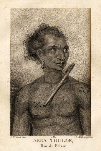
178814520Paris, Le Jay et Maradan, 1788 ; 2 tomes in-8 ; demi-chagrin noisette (reliure moderne) ; (4), 282 pp., portrait du capitaine Henri Wilson en frontispice, gravé par Mme Massard d'après I. Russell, grande carte géographique dépliante, 7 planches gravées dont 6 dépliantes ; (4), 274 pp., (3) ff. Errata et Approbation, 8 planches gravées dont 6 dépliantes, soit 17 planches au total ; vocabulaire de la langue Pelew pp. 251-267 du tome II.
183314286J. Morlent Le Havre 1833 1 vol. In-8 de XVI 280 pp., demi-basane fauve de l'époque, dos lisse fileté, pièce de titre, couverture conservée.