6 262 résultats
63080248Springer pp. 432 . Hardback. Used. Springer hardcover
52957P., Plon-Nourrit, 1908, in 8° relié demi-chagrin vert, dos à nerfs, couvetrure illustrée conservée, tête dorée, II-296 pages ; quelques infimes frottis.
4to [29.5 x 21 cm]; [xiv], 386 pp, 107 colored illustrations on plates, 371 monochrome illustrations on plates, bibliography, index. original brown cloth, gilt title lettering on spine and cover, slight stain at lower spine else near fine in very good dj (short tear, light stain at edge). A picture of this book is available upon request by email. A profusely illustrated work based on the collection of the Tropen museum in Amsterdam but with consultations of collections in Netherlands and United Kingdom. It discusses each of the hundreds of prints and books, that were published in Netherlands, United Kingdom and Indonesia in the nineteenth century, with collations, details of publication, artists, engravers, biographical information, etc, with a section on early lithographic printing in Indonesia.
12mo [19 x 13.5 cm]; 355, [iii, ads] pp, extra lithographed title page with vignette, frontis, plates, map, other engravings in text. original blind-stamped cloth with gilt picture on front cover, gilt spine title lettering, spine ends chipped, corner wear, very lightly foxed on few leaves, else very good solid copy. A picture of this book is available upon request by email. The illustrations include Kealakekua Bay, Kaahamunau, old Hawaiian idols, Lahaina at Maui, Wailuku, double canoe, coral island and the plate of surf-playing, an early plate of surfing. Smith C45: 'A good picture of the islands at that time'. Hill p. 51: 'This interesting work relates mainly to Cheever's wide travels among the Hawaiian Islands and to his observations of them. Much interesting data is included on the history and native culture of the islands. Chapters are given on the first Hawaiian college and on Hawaiian literature. Cheever predicted eventual American rule of the islands.' Hunnewell 30.
8vo [22.5 x 15 cm]; 320 pp, frontis, 54 illustrations from photos on plates, foldout map of Philippine Islands, South China Sea to Siam, Sumatra showing route in red, with the errata sheet (often lacking), index, title page printed in red and black. original cloth with gilt spine title lettering, lightly foxed at outer edge, signature of R. G. Pennington on endpaper, a very good copy. A picture of this book is available upon request by email. Robinson 233. The author and her husband Talbot, a restless and dissatisfied explorer, went plant hunting in the Andaman and Nicobar Islands, and although the main purpose of the expedition, the author describes their travels to Rangoon, Siam, Singapore, Batavia and all parts in between as well with good descriptions of the peoples, their customs, conditions, etc, with plant hunting forming a small part of the book.
8vo [23.5 x 16 cm]; xi, 375, 32 [ads] pp, frontis, 2 tinted maps including one folding, numerous engraved illustrations from drwgs including full-page, index. original pictorial gilt green cloth, corners and part of joint worn, very light foxing on a few leaves, a very good clean copy. A picture of this book is available upon request by email. Not in Hill. Hocken p. 269. The author's brother, R. H. Meade, edited the work from the original journals after he was killed in an accident. The author was a Lieutenant of English naval ships sailing in southern waters. Much of the book is on the expedition from Auckland to Lake Taupo in the northern island with good descriptions of the land and the native peoples. About a third of the book relates to the author's travels to various islands in the South Pacific including Solomon Islands, Norfolk Island, Friendly Islands, etc. 'Much valuable information on the country and a rapidly changing pattern of localities, all graphically recounted' (NZ National Biography). The illustrations are from the author's drawings.
8vo [22.5 x 14 cm]; iv, 112 pp, folding engraved map frontis showing Indian Ocean, Africa, the routes; plan of that coast of Isle of France; plan of landing of British army in Mapou Bay, Isle of France; engraved view of Cape of Good Hope. later brown cloth with title lettering on paper spine label, interior is quite clean and near fine, very minor foxing. A picture of this book is available upon request by email. National Maritime Museum 453. Royal Geographical Society Catalogue 572. The ship was commanded by Captain Philip Beaver. Much of the work describes the British attack on the Isle of France. 'Prior was born at Lisburn, Ireland in 1790. He entered the navy as a surgeon, served abroad and at home, became Deputy-Inspector of Hospitals in 1843, and was knighted in 1858. He was the author of several popular works: Voyage to the Indian Seas in 1810-11; Memoirs of Edmund Burke (1824); Life of Oliver Goldsmith (1836); Life of Edmond Malone (1860). His Burke and Goldsmith have gone through many editions, and are still looked upon as standard works. He died 14th November 1869'. [A Compendium of Irish Biography]
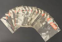
19455514<p>Set of 17 issues of Brief all from 1945. Each issue includes a full page photo of a pin-up girl on the back cover. Models include: Marguerite Chapman Virginia de Luce Lana Turner Belita Dorothy Morris Ava Gardner and many others. In addition to being a news and information publication Brief also strives to acquaint the men with the accomplishments of the personnel of AAFPOA. Creasing and occasional fold lines down middle a few have some water staining to back wrap see images. 18 pp. 9 x 12 inches. Complete list of issue dates: 9 Jan 6 Feb 13 Feb 20 Feb 27 Feb 6 March 13 March 5 June 12 June 19 June 26 June 3 July 10 July 24 July 7 Aug 14 Aug 28 Aug.</p> Information and Education Division of AAFPOA paperback
4248449like new. unknown
Anchorages on the North Coast of Tubuai Island From the latest F rench Government Chart. Tubuai Island From the latest French Government Charts. London Published at the Admiralty, 25th Feb. 1898, under the Superintendence of Rear Admiral Sir. W.J.L. Wharton, Hydrographer.Small corrections: 1923. Autore: Admiralty Charts. Luogo: Tubuai Islands - Pacific Ocean. Anno: 1898 [1923]. Tecnica: incisione. Dimensioni: 627x460 mm
Guadalcanal and Florida I.s with a portion of Malaita I. The South coast of Florida I. and North coast of Guadalcanal including Savo I are from Surveys by Commander R.W. Glennie and the Officers of H.M. Surveying Ship "Sealark", 1910-12, the remainder of the work is from various rough and imperfect sketch surveys of earlier date. West coast of Malaita I and Alite Reef, adjusted to positions determined by Lieut. Com. R.L. Hancock & the Officers of H.M.S. "Sealark", 1914. London Published at the Admiralty, 6th Nov. 1893, under the Superintendence of Captain W.J.L. Wharton, Hydrographer. Large corrections 10 th Jan. 1930. Interesting map of Guadacanal in which the capital Honiara is missing because it will be constructed only afet the second world war. Folded editorially. Autore: Admiralty Charts. Luogo: Guadalcanal - Solomon Islands - Pacific Ocean. Anno: '900. Tecnica: incisione. Dimensioni: 658x983 mm
Passes and Anchorages in Tuamotu or Low Archipelago. In the left side of the chart insert of Rarola Pass and Anchorage From the French Government Survey, 1904, Makemo I.N.E. Pass and Anchorages From the French Government Survey, 1874. With additions from the United States Government Survey, 1899. In the upper middle part of the chart insert of Tahanea I. Passes From the French Government Survey, 1902. London Published at the Admiralty 9th July 1907, under the Superintendence of Rear Admiral A. Mostyn Field, Hydrographer.Small corrections: 1920. Folded editorially. Autore: Admiralty Charts. Luogo: Tuamotu Islands - Polynesia - Pacific Ocean. Anno: 1907 [1920]. Tecnica: incisione. Dimensioni: 619x977 mm
Pekoa or Segond Channel and Wawa or Bruat Channel Surveyed by Lieut. & Commander H.E. Purey Cust, Assisted by Lieutenants W. Pudsey-Dawson, F.C. Pasco & A.E.H. Marescaux H.M. Surveying Ship "Dart", 1892. London Published at the Admiralty, 15th Jan. 1894, under the Superintendence of Captain W.J.L. Wharton, Hydrographer. It is interested to note that on the Island of Espiritu Santo the city of Luganville is missing it will be constructed after the Second World War. Small corrections: 1922. Folded editorially. Autore: Admiralty Charts. Luogo: Espiritu Santo Island - Aore - New Hebrides Islands -Pacific Ocean. Anno: '900. Tecnica: incisione. Dimensioni: 965x651 mm
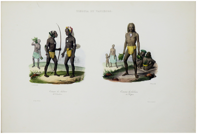
Santa Cruz I.s - Santa Cruz I. by Admiral Bruny D'Entrecasteaux 1793 Duff Group by Capt. J. Wilson of the Ship Duff 1797 Vanikoro I.s by Capt. Dumont D'Urville 1828 Swallow Group by Nav. Lieut. T.C. Tilly R.N. of the Mission Schooner Southern Cross. In the right side of the chart insert of Carlisle Bay Sketch by Lieut. H.R.M. Williams, H.M.S. Torch, 1897 and Graciosa Bay From a French Gov. Survey 1888. In the lower part of the chart insert of Mohawk Bay By Lieut. A.C. Scott, Assisted by Lieut. P. Robarts. H.M.S. Mohawk, 1898. London Published at the Admiralty 21st Febr. 1870, under the Superintendence of Capt. G.H. Richards, Hydrographer.Small corrections: 1929. Autore: Admiralty Charts. Luogo: Santa Cruz Island - South west Pacific Ocean. Anno: '900. Tecnica: incisione. Dimensioni: 634x474 mm
Solomon Islands From All available information in the Hydrographic Department to 1931. In the left side of the chart insert of Gazelle Harbour From the German Government Charts to 1919, Gizo Anchorage by Lieut F.J. Rendell & Nav. Sub. Lieut J.W. Brown 1875. London Published at the Admiralty 7th July 1874, under the Superintendence of Captain F.J. Evans, Hydrographer. Small corrections. Folded editorially. Autore: Admiralty Charts. Luogo: Salomon Islands - Pacific Ocean. Anno: '900. Tecnica: incisione. Dimensioni: 660x990 mm
17502180[], [], [1750 ca]. In-4 de 8 pp., cartonnage moderne.
New York, Charles Scribner´s Sons, 1899. 4to. mayor, XIII - 412 pp. Con 43 láminas fotográficas, 3 planos y dos mapas plegados. Encuadernación original en tela estampada, fatigada. El autor fue vecino de Robert Louis Stevenson en Samoa entre 1890 y 1893 en que como alma itinerante partió hacia la Polinesia Oriental en busca de islas vírgenes. A su vuelta a Sidney se topó con Louis Becke quien le habló de una isla que llamaba Venecia cubierta enteramente por la jungla y situada "en el mar de las pequeñas islas". Es así como fue a parar en las Carolinas, sobre las que escribió éste primer libro, fascinado por su belleza y por el misterio de las ruinas monumentales de Lele Island. . Cabe recordar que el año de publicación de esta obra España había vendido las islas a Alemania.
19892801989 - broché - Published by CTA - Produced and designed by Chayce Publications - Printed by E.P. Lowe Ltd. - 1989 - In-8 (24 x 18 cm) broché - 93 pages- ISBN-10 : 9290810572 ISBN-13 : 9789290810575 - Ouvrage en anglais - This volume is one of nine agricultural bibliographies. Other books in the Agricultural development in SADCC countries include: Botswana, Lesotho, Malawi, Mozambique, Swaziland, Tanzania, Zambia, Zimbabwe - The Southern African Centre for Cooperation in Agricultural Research (SACCAR) is a unit of the Southern African Development Coordination Conference (SADCC). It was established at Gaborone, Botswana in 1984 to provide a centre for the promotion of regional cooperation in agricultural research and the development of research manpower and training.
1785LBW-2858[1785]. 237 x 173 mm.
1774LBW-2851[1774]. 235 x 464 mm.
Carta geografica tratta dall'atlante della relazione di James Hawkesworth "Cartes et figures des voyages entrepris par ordre de sa Majesté Britannique pou fair des découvertes dans l'hémisphère méridional; exécutes par Byron, Carteret, Wallis & Cook dans les vaisseaux le Dauphin, Le Swallow & l'Endeavour" pubblicata in più edizioni di lingua francese, inglese, olandese ed italiano. Incisione in rame, in ottimo stato di conservazione. Map of the atlas is the report by James Hawkesworth "Cartes et figures des voyages entreprise par ordre de sa Majesté Britannique pou fair des découvertes dans l'Hémisphère southern exécutes par Byron, Carteret, Wallis and Cook dans les vaisseaux le Dauphin, Le Swallow & Endeavour "published in multiple editions of the English, French, Dutch and Italian.A map of Tahiti and the surrounding islands discovered by Wallis, Carteret and Cook in the years 1765, 1767 and 1769.The map shows Maurua, Tubai, Bolabola (Bora Bora), Otaha, Ulietéa and Huaheine. This group of islands was identified by Cook in 1769 when he wrote in his journal, "So call'd by the Natives and it was not thought advisable to give them any other names but these three together with Huaheine, Tubai, and Maurua as they lay contiguous to one another I have named Society Isles."
Carta geografica tratta dall'atlante della relazione di James Hawkesworth "Cartes et figures des voyages entrepris par ordre de sa Majesté Britannique pou fair des découvertes dans l'hémisphère méridional; exécutes par Byron, Carteret, Wallis & Cook dans les vaisseaux le Dauphin, Le Swallow & l'Endeavour" pubblicata in più edizioni di lingua francese, inglese, olandese ed italiano. Incisione in rame, in ottimo stato di conservazione. Captain James Cook (1728-79), explorer, circumnavigator and hydrographer. Three voyages, 1768-71, 1772-75 and 1776-79. From 1778 on printed editions of ' Captain Cook's Travels' appeared in English, Italian, French and Dutch. A map of the Society Islands. From a Dutch edition of "Cook's voyages". Copper engraving. Traces of the original folds. Perfect conditions.
1833LBW-5464[Paris, 1833]. 220 x 335 mm.
1833LBW-5456[Paris, 1833]. 427 x 580 mm.
1833LBW-5463[Paris, 1833]. 250 x 350 mm.