6 262 résultats
19021511San Francisco 1902. Very good. 120pp. including twenty plates many folding. 12mo. Original limp calf front cover gilt lettered. Light wear to spine and extremities. Internally quite clean. A very interesting early 20th-century manual and rule book for personnel in the Maintenance and Way Department of the Southern Pacific Railroad. Contained here are rules and instructions for a wide array of railroad employees including roadmasters bridge superintendants trackmen bridgemen and other watchmen. The principal portion of the text comprises nearly 270 general rules and regulations such as those governing the adjustment of woodtruss bridges lining and surfacing track keeping clear rights of way and establishing standards for numerous other basic repairs on track ties signals and other critical infrastructure. A short appendix contains laws from the several states in which Southern Pacific operated regarding the accidental killing of livestock by trains and railroad employees. At the rear are twenty plates many folding with reference diagrams for track and other maintenance projects.<br /><br />This edition is revised from the first edition of 1898 with a substantially different pagination. Several plates have been excised from the rear of this copy; however the only other copy that we locate of this work at UC Santa Barbara also is lacking a number of plates. books
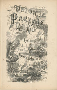
186849559New York: Published by the Union Pacific Railroad Company 1868. 1868. RAILROAD. First edition. 8vo. Original pictorial printed wrappers 32 pp. frontispiece Map of the Union Pacific Rail Road and its Connections introduction. Details the formation of the company and the progress of the work including the topography character of the country and distances along the line. Much information is provided regarding agricultural resources timber minerals etc. Branches and connecting roads along with the needed resources for construction are discussed as is information on actual earnings anticipated earnings and the issuance of the company's first mortgage bonds. A wonderful advertisement on the rear cover panel offers First Mortgage Bonds at par principal and interest Payable In Gold. A faint vertical crease and very lightly toned at the cover edges else a near fine bright copy. Published by the Union Pacific Railroad Company, 1868. unknown
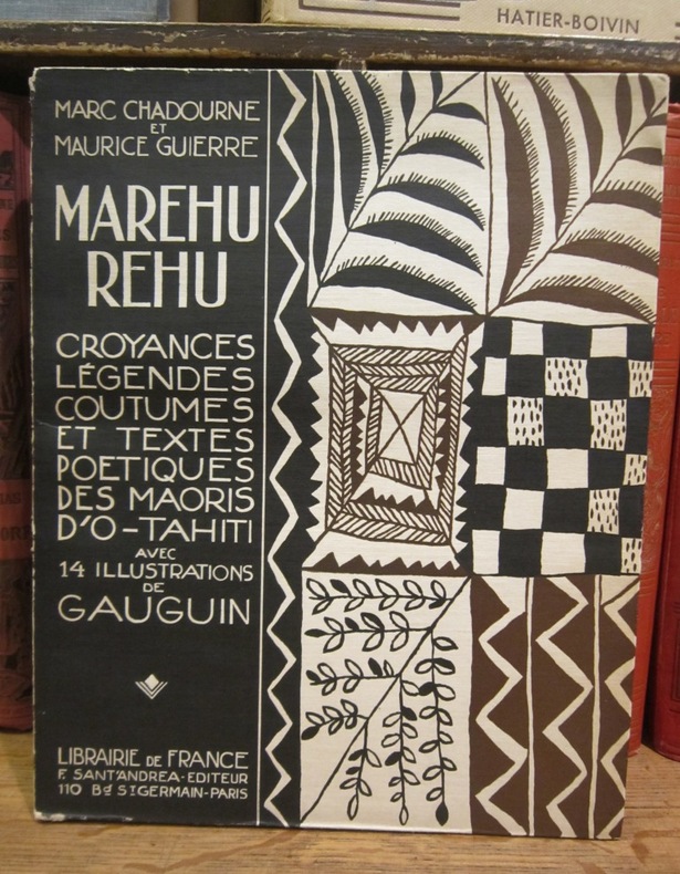
1925003212Librairie de France, F. Sant'Andrea éditeur, 1925
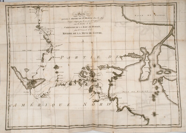
PHO-1184Paris, chez Patris , an VII (1799), 2 volumes in-8, lviii-373 pp ,332 pp.-xix , relié plein basane raciné , dos lisse orné avec titre et tomaison , tranches jaunes mouchetées ,T1, titre , extrait du 3eme voyage du capitaine Cook , A la Pérouse , préface , grande carte de la route de Samuel Hearne (60x80cm)déchirure sans manque , introduction, 2 planches et 2 cartes ,T2 , 3 cartes et 2 planches , table des chapitres , errata et placements des planches , intérieur très frais. Complet des 9 planches et cartes , 1 carte volante , manque page 17 à 32 .
1797LBW-2785[Paris, 1797]. 510 x 699 mm.
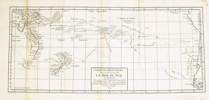
1774LBW-6111774 235 x 535 mm.
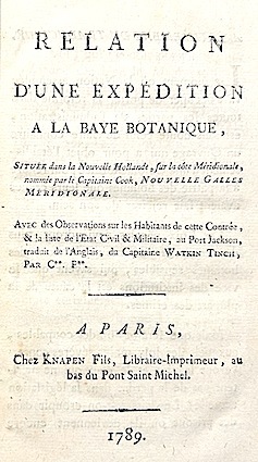
178915722Knapen fils Paris 1789 1 vol. In-8 de 8 ff.n.ch. 136 pp., pleine basane racinée de l'époque, dos lisse orné (frotté), pièce de titre, tranches jaspées (coiffe supérieure arasée, une charnière fragile).
1840LBW-3642[1840]. 220 x 291 mm.
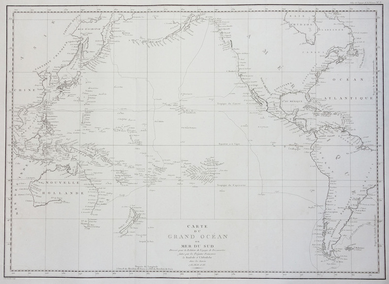
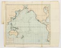
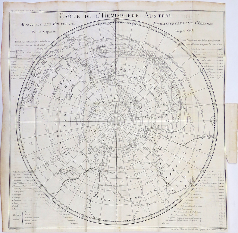
1790143934Paris: F. Dufart 1790. Very Good. Paris F. Dufart circa 1790. A hand-coloured engraved map printed surface 378× 415 mm sheet size approximately 420 × 540 mm. 'Gravée par Tardieu l'Ainé . Dessiné par Poirson . Ecrit par Beaublé'. Original folds as issued; some minor uneven tanning; in very good condition. An uncommon chart of the Pacific Ocean and Australia showing magnetic variation and dip drawing on observations made in the course of Pacific voyages after 1775 most notably Cook's third voyage. It is most likely from a duodecimo edition of Buffon's 'Histoire naturelle générale et particulière' around the end of the eighteenth century 'PL. III. Tome XVI' and 'Page 58' are printed in the top margin. It is based on a larger chart in four sheets attributed to Jean-Charles de Borda. The engraver Tardieu is one of half a dozen members of the family working as engravers at the period one of whom P.A.F. Tardieu would engrave the charts published in the official account of the Baudin voyage. F. Dufart unknown
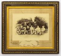
1888134827Sydney: Kerry & Jones 308 George Street 1888. Sydney Kerry & Jones 308 George Street 1888. A high-gloss gelatin silver photograph 222 × 296 mm laid down within a gilt border on the original cardboard mount with the photographic studio's details in gilt in the bottom margin. Also mounted there is a small gelatin silver photograph 47 × 165 mm of the signatures of the eight participants 'Government House Sydney Jan. 25 1888' is written below the original signatures. The item is in a contemporary frame wood with gilt-decorated plaster a little chipped now lacking the original glass visible image size 315 × 350 mm external dimensions 423 × 458 mm. The contemporary label of Cole's Book Arcade Melbourne is mounted on the verso. The main photograph has a couple of tiny surface chips to the top edge and a few tiny marks to the bottom right-hand corner; the mount is a little marked possibly lightly water-streaked but fortunately the photograph is untouched; these trifling blemishes have little impact on this fine portrait. This informal group portrait features the Governors of each of the Australian colonies along with the Governors of Fiji and New Zealand. It was taken on 25 January 1888 the day before the centenary of the arrival of the First Fleet at Port Jackson the main reason for their presence in Sydney. It features left to right Sir Robert George Crookshank Hamilton 1836-1895 KCB LLD Governor and Commander in Chief of Tasmania and its dependencies; Sir Anthony Musgrave 1828-1888 GCMG Governor of Queensland; Sir Charles Bullen Hugh Mitchell 1836-1899 Governor of Fiji; Henry Brougham Loch 1st Baron Loch 1827-1900 GCP GCMG PC Governor and Commander in Chief of Victoria; Charles Robert Wynn-Carrington 1st Marquess of Lincolnshire 1843-1928 KG GCMG PC JP DL Governor of New South Wales; Sir Frederick Napier Broome 1842-1896 KCMG Governor of Western Australia; Lieutenant General Sir William Francis Drummond Jervois 1821-1897 GCMG CB FRS Governor of New Zealand; and Sir William Cleaver Francis Robinson 1834-1897 GCMG FRGS Governor of South Australia. <p>Extensive research notes come with this item; they were compiled with the assistance of Dr John Fahey author of 'Australia's First Spies' Sydney 2018 and 'Traitors and Spies: Espionage and Corruption in High Places in Australia 1901-1950' Sydney 2018. Among much else the notes have identified a slightly variant photograph taken at the same time as this one held by the Blue Mountains City Library; the identity of the sitters comes from a letter and diagram sent to them from the Mitchell Library in 1929. 'From the various sources available most notably the title given by the State Library of New South Wales this photograph commemorates an unofficial side-meeting of these Governors to discuss Australia's interests in the South Pacific'. Dr Fahey puts it more succinctly when he says it likely offers 'evidence of one of our earliest "secret" off to the side policy conferences'. The notes provide a lot more background information for the purchaser. A few incidentals not mentioned there: Sir Anthony Musgrave was Governor of South Australia from 1873 to 1877 and he died on 9 October 1888; Sir William Jervois was Governor of South Australia from 1877 to 1883; Sir William Robinson was Governor of Western Australia three times between 1875 and 1895 1875-1877 1880-1883 and 1890-1895. Provenance: the Sloane Pastoral Family of the Riverina purchased at the estate clearing sale in April 2021. Kerry & Jones, 308 George Street unknown
MA05F-00383U. S. Government Printing Office. Collectible - Good. Washington D.C.: U. S. Government Printing Office 1946. Sm 4to. viii158pp. Folded illustrations maps. Good book. strategic bombing Japan electric utilities Inquire if you need further information. U. S. Government Printing Office unknown
Features: Steel Bridge Across Chehalis River at Aberdeen Formally Opened - article with photo; The Panama Canal Route for Canadian Northwest Shipping; Photo of Charles M. Hays, president of the Grand Trunk Railway; Address to General Passenger Agents by Howard Elliott, president of the Northern Pacific Railway (four pages); Brief business biography of George W. Hibbard, General Passenger Agent of the C.M. & P.S., with photo; Bernard N. Baker's Steamship Line a Golden Opportunity; Puget Sound Tugboat Co. on the Columbia River; New Boilers for North Vancouver Ferries; Steamer Maunganui Launched; Review of the Charter Market; Casualties to Pacific Coast Shipping; Modern Aids to Navigation Demanded for Alaskan Waters - article including lengthy list of vessels lost; Excellent illustrated centerfold makes the case for lighthouses in Alaskan waters; Review of Marine Insurance and Shipping Law; Address by president of the San Francisco Merchants' Exchange, Robert Dollar, entitled "The American Merchant Marine As It Affects Our Foreign Commerce" - with photo of Dollar; and more. 44 pages including several pages of nostalgic ads, some illustrated in black and white, featuring local marine and rail interests. Printed upon glossy coated stock. Average wear. Binding intact. Few library markings to front cover. A well-preserved copy of this highly-informative memento of Pacific Northwest transportation over a century ago. 12" x 9". Magazine
Features: Big Improvements by Northern Pacific During 1912; Through Service Seattle to Texas; O.-W. R. & N. Enter Vancouver; Will Carl Gray Succeed L.W. Hill? - article with photo of Gray; Dangers Attending Hauling Explosives; New H-H-1 Locomotive Design; Seattle's Greatest Opportunity; Bush Terminal Company to Build on Harbor Land - article with photo of Model Loft buildings at the New York Bush Terminal, similar to those to be built on Harbor Island; Portland's Proposed Harbor Front Development and the Commission of Public Docks - major article; South and Central American Trade; Great Prospects for Vancouver, B.C.; The Official Statement of the [Seattle] Port Commission re: improvements and facilities; Economy of the [Seattle] Municipal Plan (part 4) - major article which includes official map of Grand Trunk Pacific Railway showing proposed extension to Vancouver and Seattle, plus map of new thoroughfare donated to Seattle by Great Northern Railway with franchise for Interbay-Ballard Route; Bogue Plans for Tacoma Harbor Are Impressive - major article with map showing City section of harbor plans; Casualties to Pacific Coast Shipping for Year 1911 - Four full pages of fine print document the voluminous incidents of the year including the vessel and damage it sustained; Photo of Strathalbyn's bow after collision; Review of Marine Insurance and Shipping Law; Big Company to use Panama Canal - International Mercantile Marine; and more. 44 pages including several pages of nostalgic ads, some illustrated in black and white, featuring local marine and rail interests. Printed upon glossy coated stock. Average wear. Binding intact. Few library markings to front cover. A well-preserved copy of this highly-informative memento of Pacific Northwest transportation over a century ago. 12" x 9". Magazine
Features: Reasons Why the Canadian Pacific is So Prosperous; Spokane Rate Decision Eagerly Awaited; Value of Steel Equipment Demonstrated in Wreck of the Crack Milwaukee Train, Columbian on May 30th east of Ralston, WA; Continued Smuggling of Opium into West Coast Ports Aboard Trans-Pacific Steamships; Professional Biography of Joseph H. Young, President of Alaska Steamship Co. - with photo; Contracts Let for Coaling Plants in Seattle and Tacoma - article with two photos; $1 Million Available for Improvements at Moran Shipyards; Record Run Between Puget Sound and Callao by Schooner Wilbert L. Smith; After 20 Years on the Seattle-Tacoma Run, Steamer Flyer is Sold - Feature article with photo; Review of Marine Insurance and Shipping Law; Photo of Steamer Tampico Submerged in Seattle Harbor; Photo of New Boilers for Steamer Charmer built by Commercial Boiler Works of Seattle; Effects of the Panama Canal on Pacific Coast - Oriental Trade; News of Tacoma; Launching of the Titanic - 1/3 page article including photo of the Titanic in drydock with man standing below her massive 100-ton rudder; Charming one-page illustrated ad for The Shasta Limited, "The Finest Train in the West" which connected Seattle with San Francisco; and more. 44 pages including several pages of nostalgic ads, some illustrated in black and white, featuring local marine and rail interests. Printed upon glossy coated stock. Average wear. Binding intact. Few library markings to front cover. A well-preserved copy of this highly-informative memento of Pacific Northwest transportation over a century ago. 12" x 9". Magazine
1922IG038951922-1964 ca. 5000 p., num. figs & pls, paperbound or disbound (= taken from journal, no covers). Published in Videnskabelige Meddelelser fra Dansk naturhistorisk Forening i Kobenhavn. Contains numerous important contributions like: Ditlevsen, Marine freeliving Nematodes / Broch, Studies on Pacific Cirripeds / Mortensen, Echinoderms from New Zealand and the Auckland-Campbell Islands / Michaelsen, Ascidiae Ptychobranchiae / Dyktiobranchiae / Krikobranchiae von Neuseeland und den Chatham-Inseln / Sérène, Goneplacidae et Pinnotheridae / Stock, Pycnogonida from Indo-West-Pacific, Australian, and New-Zealand Waters / Odhner, New Zealand Mollusca / Carlgren, Actiniaria from New Zealand and its Subantarctic Islands / Bronsted, Sponges from New Zealand / Bock, Planarians / Boschma, Madreporaria. I. Fungiidae / Weber-van Bosse, Algues de l'Expédition danoise aux îles Kei / Augener, Polychaeta von Neuseeland and many other contributions. We added a biography and bibliography of Th. Mortensen.
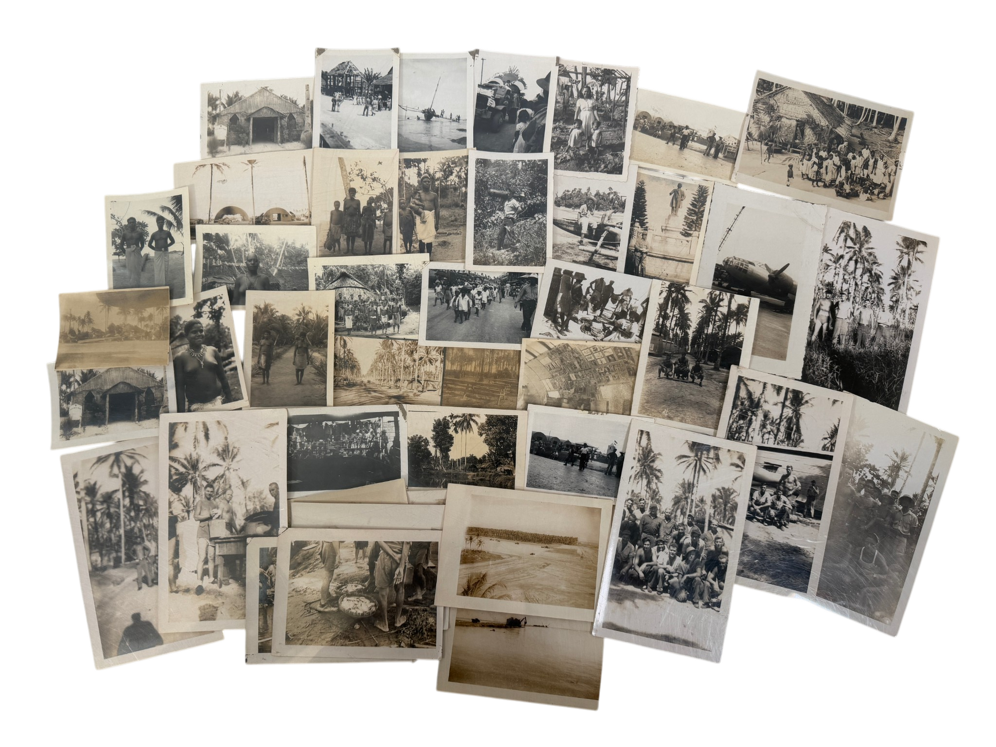
1944231791944. WWII Indigenous Peoples U.S. soldier photographs recording military occupation transport and daily movement across the Admiralty Islands Samar and the Philippines during World War II and its immediate aftermath establishing how American forces operated through island bases coastal landings aircraft facilities and encounters with local indigenous communities. Made and retained by an unidentified American serviceman the group follows the circulation of personnel through several linked wartime zones rather than a single camp with local captions on the versos anchoring parts of the sequence to "Admiralty Islands" "Samar Island" and the "Philippines." This archive showcases soldiers posed at encampments and beside aircraft landing craft and small boats military vehicles moved through settlements and photographs of Indigenous and Filipino civilians showing the human landscape through which U.S. forces advanced occupied and remained into the surrender period.<br /> Photo archive of 45 likely silver gelatin photographs ranging from 2.5 x 3 to 3.5 x 5.75 inches Admiralty Islands Samar and the Philippines circa 1944 to 1945. Numerous versos carry manuscript identifications including "on Admiralty Islands" "Natives on admiralty Islands" "Samar Island" "Samar Philippines" "Philippine" and "chapel in philippines" while several prints bear circular "Passed by Naval Censor" stamps and one caption reads "Jap bomber Betty Sept. 1945 Samar" fixing at least one portion of the group to the post surrender occupation moment. The images include shirtless American servicemen posed in palm lined camps group portraits outside Quonset huts or temporary structures a parked twin engine military aircraft a beached or near shore vessel soldiers gathered around tables and equipment and an Asian soldier who looks to possibly be in Japanese uniform standing in front a monument. Many photos show the local community with views of thatched buildings colonial era religious structures village crowds market or street scenes women and children gathered before huts and several close portraits of Indigenous islanders.<br /> The photographs belong to the final phase of the Pacific war when the Admiralty Islands served as a major Allied base complex after the 1944 campaign and Samar remained part of the wider Philippine theater retaken from Japanese control and held through the end of the war. This on the ground perspective shows how soldiers' photos moved through censorship channels recorded the built infrastructure of island warfare and fixed the asymmetrical encounter between U.S. servicemen and local populations. Minor surface and edgewear album glue residue en verso images remain clear and writing legible; overall very good condition. The combination of location notes naval censor stamps aircraft and coastal transport scenes and sustained views of local communities offer a raw visual representation of American military presence across the Southwest Pacific. unknown
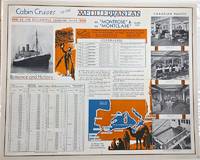
1930P2619Montreal: Canadian Pacific c. 1930. Very Good laid-down on acid-free paper for long-term preservation. Notes: A charming view of Canadian Pacific Montrose and Montclare. Image Size : 470x568 mm 18.50x22.36 Inches Platemark Size : Paper Size : 479x601 mm 18.86x23.66 Inches Coloring: Printed in Color Medium: Offset Lithograph Categories: Advertising; Transportation Ships; Canadian Pacific unknown
189132829St. Louis: Woodward & Tiernan Printing Co. n.d. 1891. 1891. First edition. Third edition. 12mo. Original orange wrappers printed in black ink 82 2 pp. illustrated map. advertising. Issued by the general passenger department of the Missouri Pacific Railway. A general description of the state and its place in history is provided. Plus soil rainfall churches schools higher educational opportunities newspapers population and wealth corn wheat oats stock farming wild flowers orchards and vineyards salt lead and zinc stone brick and lime coal gas hunting and fishing cities irrigation etc. Views are offered of farms and ranches parade grounds city parks etc. of various cities. Herd 1204 says "Issued by the Missouri Pacific Railway Company this book appeared in many editions though all are now rare." Prior to this copy the earliest edition of a similar booklet was a 13th edition and that was 15 years ago. Fine clean copy with a fine folding map. An exceptional copy of a rare item. Woodward & Tiernan Printing Co., n.d. (1891)]. unknown
2 vols., 8vo., First Edition, with title-vignettes, several illustrations in the text and 2 maps (one double-page) on green stock; handsomely bound in full dark red crushed morocco, sides framed in gilt, backs gilt with raised bands, second and fourth compartments ruled and lettered in gilt, hand-made endpapers, ribbon markers, white blocking from original upper boards preserved and mounted on new and separate leaves at front, custom-made slip-case, an elegant set ideal as a gift or for presentation. Bright set of Grimble's classic travel-autobiography set in the Gilbert and Ellice Islands of the Central Pacific
191264223Portland OR: American Map and Reproducing Company Corner E. Stark & E. 43rd 1912. One double atlas folio colour lithograph map sized 28 x 40.5 professionally mounted on archival linen sized 32 x 45 in. w/ scale of 1:24000 minor edgewear slight age toning at fore-edges and lower corner still a VG bright copy. First edition of this very uncommon Progressive Era map of Portland Oregon in the years between the Lewis & Clark Centennial Exposition and World War I. The map depicts public lands including township range and section grids along with neighborhood and addition place names steam & electric interurban railroads and electric streetcar lines along with parks city limits and radial distances from point in downtown Portland included. Place names included Zion Town the old steel bridge built in 1888 followed by a new Steel bridge which opened later in 1912 the Plank/Old Canyon Road Laurelhurst and others. Of particular interest beyond most maps of Portland during the era this map delineates a significant portion of Vancouver Washington prior to the construction of the Interstate Bridge across Hayden Island as well as inroads into portions of Northwest Portland and Washington County in the Southwest. Fritsche 1877-1928 was an intrepid German-American photo-lithographer architect printer and later photographer who first arrived in New York before coming West to the Pacific Northwest in 1907 where he set up an architecture and engraving firm with his brother Rudolph Fritsche. Wenzel is perhaps best remembered as architect of the historic Henry C. & Wilhemina Bruening House Craftsman bungalow located at 5919 North Williams in Portland’s Humboldt neighborhood erected in 1910. However by 1914 Wenzel had returned to Manhattan with his family including one son and three daughters. Worldcat locates 5 copies U of IL Boston Pub. OHS Reed U of O. American Map and Reproducing Company, [Corner E. Stark & E. 43rd], unknown
1910WRCAM46067Various locations 1910. 26pp. containing eighty-six photographs nine colored photographs and one photographic postcard. Two photos 8 x 6 inches the remainder approximately 3 1/2 x 4 1/2 inches. Oblong quarto. Original black cloth. Binding separating from text block; corners and extremities worn. Photos clean many with manuscript captions. Good plus. Photo album of assembled snapshots showing various parts of Japan the Philippines Alaska Hawaii and Washington State. The two larger images are of Snoqualmie Falls in Washington the first showing the park area and the second showing the falls itself. The images appear to be in no particular order with scenes from all the various locales dispersed throughout the album. Other photographs show scenes in Manila including the "oldest church" a "Spanish transport sunk by Dewey" in the Spanish-American War Fort Malata other churches some water buffalo and other rural scenes in the area. Images of Honolulu include a group of school children the palace views in a park and some rural scenes including a waterfall. Images of Japan are primarily from Nagasaki Kobe and Osaka. They include views of the harbors and ships the dry dock at Nagasaki the lower and upper falls at Kobe Japanese peddlers aboard a ship "temple 2000 years old" at Nagasaki among others. Views of Alaska are primarily taken from off the coast showing Dutch Harbor from several angles. <br> <br> The transport ship Oopack is featured in several photos; the Oopack was a British merchant vessel that was sunk by the Germans in 1918 off the coast of Malta. Several unlabeled photos at the rear of the volume show what are presumably local scenes from home likely the Pacific Northwest. There are two farmers plowing a field behind a horse bathers at the seashore picnickers and other group photos. The picture postcard is a baseball team group shot and the colored images are views of Japan. hardcover books
1837PHO-2143Paris, Arthus Bertrand, 1837, 1 volume (3) grand in-4° (30x24,5cm), VIII pp., 742 pp., demi basane époque, dos lisse avec auteur, titre et tomaison, frottements au dos, quelques rousseurs, défaut à la coiffe sup., de la bibliothèque de Cayrol avec son cachet et signature manuscrite.
176714642Molini Paris 1767 1 vol. In-12 de 2 ff.n.ch. LXVIII 335 pp., veau fauve de l'époque, dos à nerfs orné, pièce de titre, tranches rouges.
1780LBW-4310[1780]. 535 x 535 mm.
1827LBW-4441[1827]. 495 x 361 mm.