6 262 résultats
NUMBER ONE OF ONLY TEN SETS OF THIS OUTSTANDING PORTFOLIO OF EXPRESSIONIST ETCHINGS, WITH MANY OF THE ETCHINGS PRINTED ON OLD JAPANESE PAPER. In 1918 German novelist Hans Bethge wrote "Satuila oder vom Zauber der Suedsee" ("Satuila or the Enchantment of the South Sea"), the story of a young woman in Samoa. It is a sensual, escapist tale: the situation in Germany was quite terrible after the defeat in WWI, and there was great demand for escapism. This novel was a hit, and a deluxe edition, with 6 original etchings by German Expressionist artist Georg Alexander Mathey, was published in Berlin in 1921. The etchings are extremely beautiful, perfectly capturing the lush sensuality of the landscape and the unabashed sexuality of the characters (similar to the depictions of Gypsies by Otto Mueller, from about the same time). This edition of the novel was limited to 250 copies. Aside from the book edition, 10 sets of the etchings were printed, with large margins. In these 10 sets, each of the etchings is signed and numbered by the artist. I OFFER ONE OF THESE 10 SETS: SET NUMBER 1, with each of the etchings numbered 1/10 and signed in pencil by the artist. FOUR OF THE SIX ETCHINGS IN THIS SET ARE PRINTED ON OLD JAPANESE PAPER, AND ARE PERHAPS UNIQUE AS SUCH. Additionally, there is a signed working proof of an early version of one of the etchings, also printed on old Japanese paper. This proof is probably unique, as the etching was never published. The set is as it was issued. Each etching (sheet size 8 1/2 x 7 inches--22 x 18 cm) is individually matted, and the original parchment-backed cloth portfolio case (16 1/2 x 13 inches--42 x 33 cm). There is a little light wear to the portfolio, but the etchings are fine and bright. An important and extremely rare item (and perhaps the only German Expressionist depictions of the South Pacific!)
4to [29 x 24.5 cm]; [ii], xxiii, [i, errata], 388, 13, [i, directions] pp, engraved frontis portrait, plus 32 engraved plates, maps and charts including 20 folding. orig full tree calf, rebacked with orig gilt decorated spine, gilt title lettering on orig red spine leather label, wear at corners & spine ends, armorial bookplate of Robert Austen, marbled endpapers, interior clean, crisp & fine with only slight foxing. Taylor 401. Cox i, 301. Hill p. 108: 'Forrest sailed from Balembangan, in the 'Tartar', a native prahu of about ten tons burden, with two English officers and eighteen Malays, towards the Moluccas. He pushed further east than any of his company predecessors, eventually reaching Geelvink Bay in New Guinea. The voyage was one of examination and enquiry . . . the tact with which he conducted his intercourse with the natives, and the amount of work done in a small boat, deservedly won him credit as a navigator'. They explored the Gilolo Passage between New Guinea and the Moluccas, then sailed to Mindanao, examining the Sulu Archipelago, Mandiolo, Batchian and Waygiou, and reaching the Malay peninsula A vocabulary of the Magindano tongue is added at the end of the book. There is much on the native people, their customs, manners, activities. The book is famous for its fine engraved plates and maps.
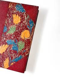
188553538Paris: Imprimé pour Isadore Liseux et ses amis 1885. First edition thus. Near fine. First vernacular translation of these suppressed Latin elegies that include the most explicit poetic expressions of homosexual desire of the Italian Renaissance. The HECATELEGIUM was first published in Florence in 1489 by a poet so notorious for his open homosexuality that Machiavelli named him in a 1501 letter as one of those poets who would have been burned at the stake had they not been protected by powerful cardinals "qui nisi haberent refugium in asylum nunc huius nunc illius Cardinalis combusti iam essent". Massimi's fame during his long life was nearly extinguished over the centuries of suppression and silence that followed which saw a heavily bowdlerized edition of the HECATELEGIUM published in Parma in 1691 and this privately printed edition in French and Latin only in 1885 the first uncensored edition since 1523. Though the Latin of this edition is complete certain obscene Latin words are printed in Greek rather than French in the facing translation still deemed too filthy to be read by anyone without a protective classical education. Undertaken by the shadowy publisher Antoine-Isidore Liseux 1835-1894 it was printed in Liseux's elegant typographical style in a "private" edition of 120 copies. Rare and important. 9.75'' x 6.5''. Later three-quarter cherry-red calf over marbled boards signed "Canape Belz" with matching marbled endpapers. Edition of 120 copies this copy no. 80. Text in French and Latin. xvi 354 2 pages. Minor rubbing to extremities. Old shelf label removed from head of spine. Else bright clean and sound. Imprimé pour Isadore Liseux et ses amis unknown
4to [30.5 x 23.5 cm]; xxix, [ii, errata, directions leaf], 360, 47 pp, 22 plates and maps including 6 folding maps and charts, tables, with the half title page (often lacking). contemporary leather backed marbled boards, gilt spine title lettering, joints rubbed, corners worn round, some light staining to about 5 plates at rear, mostly marginal, generally clean and unmarked, very good, a tall copy with wide margins. A picture of Two ships, the King George commanded by Portlock and the Queen Charlotte, commanded by George Dixon, visited the Falkland Islands, made a long stay at Hawaii, then proceeded to survey the American coast, to more accurately map the coast and to establish a British presence in the region's fur trade. National Maritime Museum 140: 'Dixon discovered Queen Charlotte Island, named after his ship'. Buck 35. Sabin 20364. Howes D365. Wickershaam 6574. Lada-Mocarski 43. Hill 352: 'This expedition set out to establish a trade in furs in North America. Dixon visited Hawaii three times in the course of the voyage. . .discovered Queen Charlotte Islands, Port Mulgrave, Norfolk Bay, Dixon Entrance and Archipelago while continuing down the coast and trading with the Indians.. . . Dixon's contribution to the work also includes the valuable maps. The accounts of this expedition relate to the geography, ethnology, and natural history of the American coast from Nootka Sound northward'. The fine plates including many views, birds, portrait, etc. One of the detailed appendices is on the natural history encountered. Dixon had earlier sailed with Cook on the Resolution
5510Chicago: Cameron Amberg & Co. Printers ca. 1880. Illustrated chromolithographic broadside with map 21.25†x 13.125†plus margins inset map measuring 4.5†x 5.875†illus. measuring 3.25†x 12.5â€. CONDITION: Very good margin chipped at upper right corner a few minor stains. <p>A rare and striking broadside issued by the Chicago Rock Island & Pacific Railway advertising the Rock Island through-express route and promoting the railroad’s numerous destinations connections and amenities.</p> <p>Featuring the eye-catching mix of typefaces and colors that characterized railroad advertising in this era this attractive broadside promotes the numerous midwestern stops and destinations accessible via the Chicago Rock Island & Pacific R’y. At this time two through-express trains for Kansas and Nebraska ran daily in connection with the Atchison Topeka & Santa Fe and Union Pacific railroads. As noted here meals were served in palace dining cars for seventy-five cents each and 150 pounds of baggage were allowed on each full ticket and seventy-five pounds on each half ticket free. The line’s various destinations included Iowa City Council Bluffs Denver Salt Lake City and San Francisco as well as “all points in Kansas Nebraska Colorado Arizona New Mexico Utah Montana and California.â€</p> <p>Showing the Rock Island R.R. in bold the inset map spans from Chicago and Lake Michigan in the east to Omaha and Council Bluffs in the west and reaches from St. Paul in the north to St. Louis and Kansas City in the south—with Lake Michigan lying in the upper-right corner. One axis of the line extends from Milwaukee and Racine Wisconsin to Leavenworth Kansas and another stretches from Chicago to Omaha. Various spurs connect to both.</p> <p>The lower section of the broadside features a marvelously detailed illustration of the interior of a palace dining car showing numerous fashionably dressed passengers seated and dining among African American waiters who are shown in the small kitchen and serving food. In the far-right end of the train men are depicted in drawing rooms—reading newspapers and smoking—and various railway operators and ticket-men appear at the ends of the car. Also included is a table of connections with various railroads that could be made in “Union depots.†Through-tickets via this route could be found on sale at all coupon offices in the U.S. and Canada. Those seeking additional information folders maps and times-tables are encouraged to contact any of the ten agents and managers of the Rock Island R.R. listed at the bottom who were based in New York Toronto Philadelphia Chicago etc.</p> <p>Established in 1847 as the Rock Island & LaSalle R.R. the company was reincorporated in 1851 as the Chicago & Rock Island R.R. Co.—its rails during this period reaching to Morris Illinois and later Ottawa. After acquiring the Mississippi & Missouri R.R. in 1866 the company was renamed Chicago Rock Island & Pacific R.R. Co. Expanding between 1873 and 1882 the company built more branch lines that reached into Iowa as well as Kansas City. In 1880 the firm was reorganized under the name Chicago Rock Island and Pacific R’y Co. and by 1883 extended nearly to the southern boundary of Kansas. After Congress granted passage across Indian Territory in 1887 the Rock Island R.R. began developing through Texas to Galveston as well as New Mexico Territory. During the 1920s the railroad enjoyed considerable success. In 1926 the company began constructing a freight line between Amarillo Texas and Liberal Kansas which was finished in 1929 and served to make accessible a country of rich grain. While the railroad industry continued fairly steadily through 1930 between 1931 and 1935 the Depression took a toll on the Rock Island R.R. and went into decline. The company ceased operation in 1980.</p> <p>OCLC records just one copy held at Yale.</p> <p>REFERENCES: “Chicago Rock Island and Pacific Railway Records†at Kansas Historical Society online.</p> Chicago: Cameron, Amberg & Co., Printers, [ca. 1880] unknown
18871408San Francisco 1887. About very good. 668pp. including numerous in-text or full page illustrations and eight photolithographed plates plus large folding map. Folio. Original pictorial wrappers. Wraps with some soiling wear at edges; front wrap with a few signs of biopredation; two small chips to rear wrapper; spine perishing at extremities. Minor worming at upper corner of a few interior leaves. Light tanning. A rare and extravagant promotional for the Pacific Cable Railway Company which manufactured installed and operated the famous streetcar system of San Francisco and in several other American cities. The present work also serves as a declaration of patent with a list of patents and patent holders at the rear and the text comprises a detailed technical description of the wire cable system with many illustrations of its mechanisms and operation as well as general accounts of the systems running in San Francisco Los Angeles Chicago and Kansas City. In addition to the technical diagrams are several attractive line illustrations and eight photolithographed plates reproduced by artotype of the cable cars of San Francisco in action all by Britton & Rey. The folding map at the rear provides a detailed delineation of the lines running across the city. Very scarce OCLC locates only five copies.<br /><br />Cowan II p.512. books
17916424A Paris, Chez F. Buisson, Imprimeur-Libraire, rue Hautefeuille, n°20. (1791). 1791 2 vol. in-8° (200 x 125 mm.) de : I. [2] ff. (titre, f. t.), viii, 466 pp.; II. [2] ff. (titre, f. t.), 486 pp. Initiales manuscrites à l'encre "L R" surles faux titres. Demi-basane dépoque, dos lisses ornés et titrés à l'or, coins de parchemin, plats recouverts de papier à la colle bleu.
Raro secondo stato della carta, proveniente dal quinto volume dell’opera Raccolta di tutti i viaggi fatti intorno al mondo da diverse nazioni dell’Europa di Jean Pierre Berenger edito nel 1794-96 illustrato con carte dell’editore veneziano Zatta. Rispetto alla medesima carta inserita in “Atlante novissimo”, cambiano il titolo e la data. Bel cartiglio figurato.Buono stato di conservazione con pieghe editoriali e traccia di restauri agli angoli delle medesime.La carta viene per la prima volta pubblicata in Atlante Novissimo dello Zatta, edito tra il 1779 ed il 1785. Atlante fra i più belli e completi mai pubblicati in Italia nel XVIII secolo, l'opera più famosa dello Zatta. L’Atlante Novissimo, come si specifica anche nel titolo, è “accresciuto sulle osservazioni scoperte fatte dai più celebri e più recenti geografi”. Tra le novità più significative vi è la comparsa delle nuove isole scoperte nell'Oceano Pacifico da James Cook e la prima carta italiana della Nuova Zelanda. Le illustrazioni furono ideate e disegnate dai suoi collaboratori Giovanni Marco Pitteri, Anton Friedrich Busching, Pietro Antonio Novelli ed incise da Giuliano Zuliani. Il primo tomo dell’atlante è introdotto da un breve saggio di geografia generale dove l’autore definisce in modo sintetico e preciso gli elementi che compongono i reticoli eclittico ed equatoriale usati nelle tavole. Interessante la sezione dove si sofferma a descrivere il fenomeno della precessione degli equinozi e quello della variazione ciclica dell'obliquità dell'eclittica. Acquaforte, stampata su carta vergata coeva, coloritura coeva dei contorni, in buone condizioni. - THE VERY RARE SECOND EDITION OF 1794 - Taken from 'Raccolta di tutti i viaggi fatti intorno al mondo da diverse nazioni dell’Europa' by Jean Pierre Berenger. The date is changed into 1794Antonio Zatta's map of New Zealand is not only one of the first to show the results of Cook's voyages, but is also one of the most attractive of the islands. Considerable coastal detail, with reference to the Endeavour's path, and a little and surmised internal detail. The map delineates two islands, tentatively identifying the Southern Island separate. The map shows Cook's tracks around the island, along with the astronomical observations. Nice topographical detail is shown, along with a blend of native and European place names on the islands. The map includes several annotations. The decorative cartouche, in full original colour, shows a native village scene. New Zealand, though discovered by Tasman in 1642, received no further European exploration until the first Pacific voyage of James Cook. Cook sailed the coast of New Zealand for 6 months, proving that it was not part of the Great Southern Continent, as many had believed. Cook visited New Zealand several times, with Zatta's map drawn from information provided in the latest of his voyages.
19048792San Francisco: Whitaker & Ray Company 1904. First Edition. Hardcover. Good. Whitaker & Ray Company San Francisco 1904. First Edition. Covers reinforced at the outer edges and spine with white tape. First free end-paper missing. Front hinge separated from the text. Moderate foxing to a few pages most pages clean and bright. -- A Juvenile book of jingles characteristic of the west. Contains jingles on such subjects as the Chinaman Cliff House Golden Gate Park etc. Beautifully illustrated by 19 full page seven color litho-prints. -- One edition published in 1904 in English and held by 2 libraries worldwide. Size: Quarto. 39 pages not numbered. -- Condition:. Whitaker & Ray Company hardcover
196010179Place of publication unknown: Self Published 1960. Deluxe Limited Edition. Very good . Oblong Folio 20" by 16". Heavy plastic overlay with title "Hilton Paints the Desert" stiff rear board. -- Introduction page with limitation inscription at the bottom in the author's hand: and his signature; "Number 52 of a deluxe edition of 350 for Leo and Irene Moore with best wishes". -- Condition. Twenty Seven Prints some duplicates twenty-five signed two not signed. Some prints signed in silver and some in regular ink. --: Hills of Home 3 - Joshuas in the Moonlight 2 - Oasis Mara 3 - Papago Dawn 3 - Power and Glory 3 - Red Mountain 2 - Smoke Trees and Thunderheads 2 Superstition Spring 1 - Sands of Tim 3 - San Jancinto Sunrise 3 - Wickenburg Yuccas 2. Self Published unknown
1868WRCAM33573AWashington: Government Printing Office 1868. 39pp. plus large color folding map 23 1/4 x 44 3/4 inches. Original printed wrappers. Presentation inscription on front wrapper see below. Wrapper edges chipped minor soiling and tanning to wrappers spine partially chipped old vertical fold to pamphlet. Light foxing and tanning and occasional soiling throughout Map with a few small closed tears at cross-folds with no loss. About very good. This copy is inscribed on the front wrapper: "With Regards of James Tilton C.E." Tilton 1819-78 was then chief engineer of the Washington Division of the Northern Pacific Railroad. Thanks in part to his support for Franklin Pierce's presidential campaign Tilton was appointed the first Surveyor General of Washington Territory and served from 1853-61. Both the Tilton River and Fort Tilton near Fall City Washington are named for him. <br> <br> An important report to Congress by the Northern Pacific Railroad headed by Minnesota railroad magnate James J. Hill for federal aid to support the Railroad's expansion to the West Coast. The petition reviews the railroad's original charter printing with it a memorial from the NPRR's Board of Directors and supporting communications from military figures including Montgomery Meigs and Ulysses S. Grant. Since the early 1850s Edwin Johnson described by Wheat as a "visionary" engineer had been associated with the plan to build a railroad across the northern part of the United States from the Great Lakes to the Pacific Coast. In 1867 he was named chief engineer of the Northern Pacific and this memorial is a work of major importance for the history of the railroad. It includes Johnson's topographical survey of the route to the Pacific a discussion of potential problems that may be encountered and a detailed economic and military survey of the area in justification of construction. <br> <br> The exceptional large folding "Map of the Country from Lake Superior to the Pacific Ocean from the Latest Explorations and Surveys" was produced by the Colton firm in New York. One of the finest maps of the region to date it shows the area from Detroit to the Pacific well into Canada and south to about the 39th parallel. Johnson has drawn the route of the Northern Pacific from Lake Superior to Washington Territory where the line splits with one branch heading toward Fort Vancouver and the other to Puget Sound. Among the details shown on the map are the Pony Express route wagon routes and overland mail routes exploration routes and other proposed railroad routes the locations of Indian tribes mineral deposits military forts and much more. Wheat gives a long description of the map and remarks that "the detail of such a map defies cataloging." Construction on the Northern Pacific Railroad began in 1870 and was completed in 1883. Edwin Johnson did not see its completion dying in 1872. An edition of this report with the supporting documents and map was also privately published in Hartford. <br> <br> A significant early account of railroad expansion in the Northwest. We could find only ten copies listed in OCLC and this is the first copy we have seen in wrappers and with a presentation from an important engineer on the project. RAILWAY ECONOMICS pp.242-43. SABIN 55819 Hartford edition. WHEAT TRANSMISSISSIPPI WEST V item 1169 pp.205-09. PHILLIPS MAPS p.916. DECKER 37:266 Hartford ed. MIDLAND NOTES 68:164. OCLC 60578657. Government Printing Office unknown books
4to, 8vo [33.5 x 26.5 & 23 x 14.5 cm]; 3 volumes including plate volume, xlviii, 536; iv, 332, clxxix pp,with large folding map, 92 plates including 10 finely hand-colored aquatints, large folding plan, music notation, other maps, tables, index. original red cloth with title lettering on front cover or spine, plate volume spine worn, mostly lacking, light foxing on some plates, heavier on a few, colored plates clean with tissue guards, text volumes bit faded but near fine, plate volume very good. First printed in 1817 in only 900 copies with only 66 plates, this edition being expanded to 92 plates and map. The plates are reputed to be by William Daniell. The author travelled extensively on the island. Abbey Travel 554; Tooley 391; Hill I, 245. According to Abbey, the atlas of plates was published separately for the second edition which was published in 1830 and printed in only a small number. Bastin p. 5: 'The book was got together with considerable haste and was published in 1817 in two quarto volumes. . .a total of 900 copies were published. Apart from its originality. . .the outstanding feature of the book is its 66 plates, ten or which are coloured aquatints illustrating Javanese life and costume and the Papuan boy who accompanied Raffles to England in 1816'. The plates of this edition include all the plates of the first edition plus additional plates of Javanese antiquities and topography. Prideaux: 'a monumental work. . . still a standard book'. Von Hunersdorff: 'An influential work valued for the author's firsthand observations on the customs and condition of the Javanese under his administration as Governor General during the British occupation of the Dutch East Indies'. The text volumes printed in 1830 have a great deal of data, much in tabular form including statistics, populartion, vocabularies, etc. with much of the author's text describing the people and country in great detail. from natural history and anitiquities to musical instruments, hunting methods, literature, games of skill, language, etc. All of the plates are present according to the plate list.
180011615John Stockdale London 1800 2 vol. 2 vol. in-8 de 487 pp. et 344 pp. 105 pp. (appendice) 2 ff.n.ch., veau fauve raciné de l'époque, dos à nerfs orné, pièces de titre et de tomaison.
1908138240High Bluff Manitoba: Edwin C. Blair c1908. Undetermined. very good. 24pp. Oblong quarto. Black cloth photo album rubbed with some loss of cloth on front board. Spine reinforced with additional patterned cloth. 24 albumen photographs loosely inserted between 12 double-mounted leaves. 10 photos are signed "Blair" a few with additional titling in pen to photo. 23 photos with a stamp on verso: "Real photographs of real life in Canada by Edwin C. Blair High Bluff Manitoba; 1 photo stamped "Photo by E.C. Blair. Two photos are dated 1908. Photos measure approximately 6.75" X 5". very good A fantastic collection of photographs documenting the construction of the Grand Trunk Railway in Alberta. Includes a variety of subjects such as horse-drawn lumber operations steam-powered construction equipment hard rock excavation construction of the Battle River and Clover Bar bridges steam locomotives and camp life. 1908 Edwin C. Blair unknown
20069787San Francisco: Pacific Editions 2006. One of 12 copies only all on Rives BFK paper each signed and numbered by Charles Hobson and Kay Bradner who collaborated on the design of the linoleum block print. Page size: 18 inches x 9 inches when closed and folded into 8 leaves and when opened fully 7-1/2 feet. There is a title page and page of text and a colophon page as well as the 8-page folded print. Bound: blue cloth spine coastal map over boards on covers with white label printed in black on front cover housed in translucent plastic slipcase fastening with cleat and sailing line on foredge fine. The central image of this book is a three foot square relief print that was created as part of a program at the San Francisco Center for the Book. It was original printed in 2005 by a steamroller at Carolina and 16th Streets San Francisco. Kay Bradner cut the linoleum block and printed it; Charles Hobson designed the book and assembled it with the assistance of Alice Shaw. The print at first glance seems to show a pleasant Sunday afternoon of sailing on the San Francisco Bay. However the position of the sailboats has been established to illustrate some of the most basic right of way rules. The rules themselves are actually embedded in the image in small window openings cut into the print. As usual with books from Pacific Editions all is meticulously crafted disparate elements aesthetically incorporated into a beautiful book. Both artists have a passion for the water and the vessels that move on it. Charles Hobson's extensive output has as a base the juxtaposition of word and image. He is a faculty member at the San Francisco Art Institute and at one time raced a Cal 20 sailboat on the San Francisco Bay where he had first hand experience with the application of the right of way rules. As with other books from Pacific Editions this too must be experienced. Turning the pages opening the "rules" windows and reveling in the deep blue of the print brings a land-locked person as close to the water as is possible. Pacific Editions unknown books
1837PHO-2280Paris, Arthus Bertrand, 1837, 2 volumes (3) grand in-4° (30x24,5cm), VIII pp., 742 pp., demi chagrin et coins époque, dos lisse avec auteur, titre et tomaison, frottements au dos, quelques rousseurs, défaut à la coiffe supérieure. Édition originale du texte du voyage du Bougainville autour du monde, manque l’atlas.
Edizione francese della mappa della Nuova Zelanda del capitano J. Cook, che riporta le rotte seguite intorno alle due grandi isole (Isola del Nord e Isola del Sud) dal 6 ottobre 1769 al primo aprile 1770.James Cook fu il primo a operare il rilevamento integrale delle coste.Esemplare tratto dalla prima edizione dell'opera "Relation des voyages entrepris par ordre de Sa Majesté Britannique . . ." di John Hawkersworth, pubblicata a Parigi nel 1774.Incisione su rame, carta irregolare il solo margine sinistro, per il resto in perfetto stato di conservazione. French edition of Cook’s foundation map of New Zealand, showing the track of the Endeavour around both islands, from October 6, 1769, to April 1, 1770.From John Hawkesworth’s "Relation des voyages entrepris par ordre de Sa Majesté Britannique . . ." (Paris, 1774). Copperplate, in very good condition.Endeavour came within sight of land on April 19, well north of the area charted by Tasman 125 years earlier. The New Holland (Australia) coast was exasperating, however, and Cook could not find a safe place to land until the afternoon of Saturday, April 28, when they entered Botany Bay (part of today’s Sydney Harbor), which Cook later named for the wide variety of plant life found there. The Aborigines that they saw there were unintelligible to Tupaia and kept away, avoiding contact. Through May and into June, Endeavour sailed north, arcing northwest, following the Great Barrier Reef coastline. On the evening of June 10, when most of the men were sleeping, the ship struck coral, stuck fast, and began leaking. Quick thinking and decisive action by Cook and his men—pumping furiously and jettisoning fifty tons of decayed stores, stone ballast, and cannons—kept the ship afloat and allowed a temporary underwater repair. A few days later, the damaged ship was safely beached on a barren shore (near today’s Cooktown, by the EndeavourRiver), and a fury of activity began more permanent work: the expedition had avoided a real disaster. (Henceforth, the British Admiralty would send Cook out with two ships for safety.) During this time, the men enjoyed more favorable interactions with the natives, but not without miscommunications and incidents of distrust. By August 13, the ship was ready to resume its journey.The labyrinth of treacherous islands and reefs was threaded slowly and carefully, with vigilance and some luck, as the expedition sailed northward through the Great Barrier Reef, westward around the northernmost point of New Holland, and into what Cook called Endeavour Strait. He stopped briefly at Possession Island (his name) where, now knowing he was in territory explored by the Dutch, he claimed the whole coastline he had just charted for King George III. It was a proud moment, essentially marking the end of Cook’s first Pacific voyage’s geographical discoveries.
1823PHO-1666London, John Murray, 1823 et 1828, 2 volumes In-4, relié pleine toile orange, dos lisse avec pièce d’auteur et titre, date en pied, xvi-768pp. et xxvi-320pp.cvii-1f., tome 1, tâche sur les 5 premiers feuillets, petites rousseurs, mouillure angulaire sur les planches au tome 2, petits frottements à la reliure. Édition originale, illustrée de 30 planches dont 11 en couleurs pour le tome et de 31 planches au tome 2, les cartes manquent, Cachet Émile Petitot, Ex-libris manuscrit, Ex-libris Jean-Pierre Legrand-Deloron. Avec une mention signée : "membre de l'Expédition arctique T.A. 23 , 1972-1973" .
183914879Pourrat frères Paris 1839 2 vol. 2 vol. in-8 de 2 ff.n.ch. 510 pp. 1 f.n.ch. (table) et 2 ff.n.ch. 547 pp. 1 f.n.ch. (table), demi-veau romantique de l'époque, dos à faux nerfs orné.
193249308N. P.: Published for the Northern Pacific Railway Company n. d. ca 1932. 1932. Color illustrated poster 40" x 30" after the painting by Gustav Wilhelm Krollman with his name and "Cascade Mountains State of Washington U.S.A. Northern Pacific Railway" in print. This striking vintage travel poster shows a view of Mount Saint Helens with its reflection in Spirit Lake many years before its dramatic eruption in 1980. Starting in the late 1920s Austrian-born artist and commercial illustrator Gustav Krollman produced a series of scenic paintings for the Northern Pacific. This view of Spirit Lake and Mt. St. Helens was one of the few that did not have a locomotive in it. Colorful original mounted poster with a tiny pinhole in each corner else in fine condition. Suitable for framing. Published for the Northern Pacific Railway Company, n. d. (ca 1932). unknown
20059671San Francisco CA: Pacific Editions 2005. First Edition thus one of 48 copies all on BFK Rives paper signed by the author Barry Lopez and the artist / designer / publisher Charles Hobson in pencil and numbered by Hobson. Page size: 11 inches x 12 inches. Bound: with original USGS maps for the concertina binding which when opened creates its own vista of mountains and valleys representing the maps that figure so prominently in the Lopez story covers made of paper over boards paper reproducing a 1911 map of Bogotá from the collection of the Library of Congress publisher's slipcase of wood-grained paper over boards with brass-toned metal label holder attached to spine of box holding white paper label with title and author in black all suggesting a map cabinet which plays a pivotal role in Lopez's story further housed in tan corrugated paper board slipcase slipcase and board covers made by John DeMerrit with the assistance of Kris Langan new. <br/> The book opens with images of hands emulating gestures of a map maker at work reproduced as digital pigment prints on transparent film. The book also contains landscape images and an image of pencils from the writing desk of Barry Lopez printed as digital pigment prints from monotypes with pastel all created by Charles Hobson. The text has been printed letterpress by Les Ferriss in Garamond Narrow type. The book and images were created by Charles Hobson who assembled the book with the assistance of Alice Shaw.<br/> Barry Lopez's THE MAPPIST was originally published in 2000 in LIGHT ACTION IN THE CARIBBEAN. It is a multi-layered story perfectly embodied by Charles Hobson's book. Themes of hidden identities searched out and deciphered hidden intentions coded in seemingly disparate actions and the tantalizing possibilities of bringing order to a chaotic history are beautifully served by the combination of maps that are the subject of the story and literally hold the story together. The story itself is certainly one of the wittiest "legends" ever devised for its surrounding map. The reader is challenged with images thrown up by the author and artist: bits of map interspersing text bits of map as foredge and gutter outside edge on any turn of the page a phrase full of possibilities "he was a patriot" and suggestions in the form of queries: was Lewis Mumford a populist When "The Mappist" gives the narrator a copy of his very rare book THE CITY OF GERANIUMS the reader is doubly seduced with this act of generosity or is it instinct to preserve one's values for the words are preceded and followed by a page of transparent film with the image of a map being passed from one hand to another. Turning the film page the reader is confronted with the act being completed and the hand off accomplished. The narrator finishes his tale with a ride down a very dark gravel road using the sound of the tires on the crushed stone as his "map." We are left wondering where will we find our maps - and will we be able to read them - or remember what we've read. Pacific Editions' THE MAPPIST will certainly help in this ongoing quest. Pacific Editions unknown books
In-8 gr. (mm. 255 x 165), 5 volumi, tela editoriale, ricca decoraz. a secco ai piatti e al dorso (2 volumi restaur. per piccole manc. ai bordi), pp. LX,434; XVI,476; XVI,438; XVI,540; XVI,558; molto ben illustrati da numerose figg. inc. su legno nel testo e da 63 (su 64) belle tavole inc. su acciaio fuori testo: sono vedute, ritratti di indigeni, loro abitazioni e cerimonie; unite 13 cartine geografiche piu' volte ripieg. Resoconto di una importante missione scientifica di esplorazione, diretta dall'ufficiale di marina americano Charles Wilkes (1798-1877). Durante il lungo viaggio vennero visitati vari arcipelaghi del Sud Pacifico, toccata l'Australia, scoperte le coste dell'Antartico oggi chiamate "Wilkes Land" e percorse le isole Fidji, Hawaii e la costa nord-ovest degli Stati Uniti; ritornata fino al Borneo via Filippine, la spedizione fece definitivo rientro attraverso la Polinesia e il Capo di Buona Speranza. Esemplare uniformemente arrossato e con fioriture ma complessivamente in buono stato.
1930P2531Montreal: Canadian Pacific c. 1930. Very Good; laid down on acid-free canvas for long-term preservation. Image Size : 685x908 mm 26.97x35.75 Inches Platemark Size : Paper Size : 724x948 mm 28.50x37.32 Inches Coloring: Printed in Color Medium: Lithograph Categories: Advertising; Transportation Ships; Posters; Canadian Pacific unknown
1860100432Large thick 4to contemporary calf spine and tips with marbled boards 70 very attractive color lithograph plates 358 41 pp. Extremeties worn minor aging one map has tear in lower corner plates bright and clean. The Pacific Railroad Surveys 1853-1855 explored possible routes for a transcontinental railroad. However the surveys went beyond looking for a place for a railroad they included and incredible amount of information on natural history and the peoples that inhabited the areas where the surveys explored. Representing the first part of the final volume of these surveys this installment focused on the northern route for a railroad. The 12 volumes included in these surveys is also known for rich illustrations many of which were in color. With 70 color plates one folding and three folding maps in Volume XII part 1 this edition is particularly rich in illustration and the plates are bright and clean. Thomas A. Ford hardcover
1860100432Large thick 4to contemporary calf spine and tips with marbled boards 70 very attractive color lithograph plates 358 41 pp. Extremeties worn minor aging one map has tear in lower corner plates bright and clean. The Pacific Railroad Surveys 1853-1855 explored possible routes for a transcontinental railroad. However the surveys went beyond looking for a place for a railroad they included and incredible amount of information on natural history and the peoples that inhabited the areas where the surveys explored. Representing the first part of the final volume of these surveys this installment focused on the northern route for a railroad. The 12 volumes included in these surveys is also known for rich illustrations many of which were in color. With 70 color plates one folding and three folding maps in Volume XII part 1 this edition is particularly rich in illustration and the plates are bright and clean. Thomas A. Ford hardcover books