2 675 résultats
1332991173.Gpaperback. Good. Access codes and supplements are not guaranteed with used items. May be an ex-library book. paperback
2010509130Oregon Archaeological Society Press 2010. Hardcover. VERY GOOD. 122pp. 122pp. Illustrated with B/W photos and drawings. 4to perfectbound in printed wraps. Clean sound copy. Out of print and scarce in trade. Oregon Archaeological Society Press hardcover
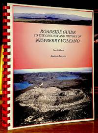
200610049Bend OR: GenOreGeoPUb 2006. Fourth Edition. Original wraps. Fine. Tall 4to. 182 pp. original paper wraps with clear plastic protectors illustrated glossary references index. -- "This book brings together much of the available information on Newberry Volcano into one publication which will be useful to the general public students teachers and geologists visiting Newberry. The book includes 19 trips covering 500 miles on and surrounding Newberry".-backcvr. -- Condition. GenOreGeoPUb unknown
19872083002116206929Asahi Shimbun Co. Ltd. Japan International Politics Research Department for the Causes of the War in the Pacific 1987. Soft Cover. Fine. Number of books: 8 Asahi Shimbun Co., Ltd. Japan International Politics Research Department for the Causes of the War in the Pacific paperback
19882080202102900340Asahishinbunsha 1988. Soft Cover. Fine. Book: 1 set Asahishinbunsha paperback
19622080202104501773Asahishinbunsha 1962. Soft Cover. Fine. Volume: 1 Asahishinbunsha paperback
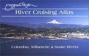
DADAX193470721XEvergreen Pacific Publishing Ltd 2015-01-20. spiral_bound. New. 0.00x0.00x0.00. Buy with confidence. Excellent Customer Service & Return policy. Evergreen Pacific Publishing Ltd unknown
SONG193470721XEvergreen Pacific Publishing Ltd 2015-01-20. spiral_bound. Used: Good. 0.00x0.00x0.00. Buy with confidence. Excellent Customer Service & Return policy. Evergreen Pacific Publishing Ltd unknown
2012Q-0945265654Evergreen Pacific Publishing Ltd 2012-02-01. Spiral-bound. New. In shrink wrap. Looks like an interesting title! Evergreen Pacific Publishing Ltd unknown
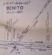
58-0555San Francisco Calif.: Southern Pacific Company 1938. Blueline print 24 x 56 inches. Yard limits and switching zones indicated in red and blue pencil. From Station Point Graves to southeastern City Limits. Includes City of Salinas. With Schedule of Property listing approx 65 transfers 1872-1938. Scale: 1 inch = 400 feet. San Francisco, Calif.: Southern Pacific Company, 1938. unknown
58-0531San Francisco Calif.: Southern Pacific Company n.d. Blackline print 24 inches x 56 inches. From Empire Avenue beyond Buena Vista Street to beyond Center Street and Burbank Boulevard. Includes Lockheed Aircraft Corporation Providencia Rancho San Rafael. Scale 1 inch = 200 feet. San Francisco, Calif.: Southern Pacific Company, [n.d.] unknown
58-0542Portland Ore.: Southern Pacific Company n.d. Blueline print 24 inches x 55 inches. From Station Point Page to approximate 3 miles south. With Isaac Hutchins Donation Land Claim Leonidas McFarland donation claim. Includes Schedule of Property listing 8 transfers 1870-1896. Scale 1 inch = 400 feet. Portland, Ore.: Southern Pacific Company, [n.d.] unknown
56-0206San Francisco Calif.: Southern Pacific Company 1958. Map. Blueline print. 24 x 54 inches. Includes Pleasanton Rancho El Valle Arroyo del Valle Laguna or Sunol Creek with Schedule of Property Acquisition Date Original Grantor/Grantee Instrument of Transfer and Remarks of Sale for 19 transfers 1868- 1958. Scale: 1 inch = 400 feet. Photo of detail. San Francisco, Calif.: Southern Pacific Company, 1958. unknown
58-0549San Francisco Calif.: Southern Pacific Company 1951. Blueline print 24 inches x 55 inches. From Willow Ranch to California-Oregon State Line. Includes Cottonwood Creek. No structures listed detailed signal and track measurements. With Schedule of Property listing approx 30 transfers 1861-1951. Scale: 1 inch = 1000 feet. San Francisco, Calif.: Southern Pacific Company, 1951. unknown
56-0215San Francisco Calif.: Southern Pacific Company 1928. Map. Blueline print. 24 x 56 inches. Includes town of Fowler Schedule of Property with approximately 30 transfers. Scale: 1 inch = 400 feet. San Francisco, Calif.: Southern Pacific Company, 1928. unknown
56-0302San Francisco Calif.: Southern Pacific Company n.d. Map. Blueline print 24" x 55" with red pencil indicating switching limits. Includes Santa Cruz and station point Eblis. From San Lorenzo Cottonwood St and River St to the north to Bay of Monterey and Santa Cruz St to the south. Scale 1" = 200'. San Francisco, Calif.: Southern Pacific Company, [n.d.] unknown
56-0352San Francisco Calif.: Southern Pacific Company 1923. Map. Blueprint 24" x 55". No details listed other than Southern Pacific Railroad land unnamed County Road and railroad track measurement markings. Scale 1" = 100'. San Francisco, Calif.: Southern Pacific Company, 1923. unknown
56-0325San Francisco Calif.: Southern Pacific Company 1961. Map. Blueline print 24" x 55". Includes three Miller and Lux subdivision plots no buildings included. With Schedule of Property listing approx. 30 transfers 1888-1961. Scale 1" = 400'. San Francisco, Calif.: Southern Pacific Company, 1961. unknown
58-0538San Francisco Calif.: Southern Pacific Company 1956. Blueline print 24 inches x 55 inches. From northwestern tip of Sierra Lands development to Ash Slough. With Sierra Vista Lands Subdivisions Chowchilla River. Includes Schedule of Property listing approx 20 transfers 1872-1956. Scale 1 inch = 400 feet. San Francisco, Calif.: Southern Pacific Company, 1956. unknown
56-0458San Francisco Calif.: Southern Pacific Company 1945. Blueline print 24" x 55". Sheet one of three. Switching limits indicated in colored pencil. From Cherokee Lane to Grant Street with approx 1 1/2 miles north and 2 miles south of station point Lodi. Includes Lodi Barnhart Tract. With Schedule of Property listing approx 110 transfers 1868 - 1945. Scale 1" = 400'. San Francisco, Calif.: Southern Pacific Company, 1945. unknown
58-0533San Francisco Calif.: Southern Pacific Company n.d. Blackline print 24 inches x 55 inches. From Garcia Avenue to Lincoln Avenue along Hemlock Avenue and California Drive. With Millbrae Burlingame Gate Bayside Manor Millsdale Industrial Park. Scale 1 inch = 200 feet. San Francisco, Calif.: Southern Pacific Company, [n.d.] unknown
56-0221San Francisco Calif.: Southern Pacific Company 1938. Map. Blueline print. 24 x 56 inches. With red and orange pencilling. Map of Mayfield with Schedule of Property Acquisition Date Original Grantor/Grantee Instrument of Transfer and Remarks of Sale for approximately 9 transfers 1809-1938. Scale: 1 inch = 200 feet. Includes index map showing sheets of Val. Sec. Scale: 1 inch = 1 mile. San Francisco, Calif.: Southern Pacific Company, 1938. unknown
56-0358Los Angeles Calif.: Southern Pacific Company 1961. Map. Blueline print 24" x 58". Includes town of Yuma with detailed railroad yard. Scale 1" = 100'. Joined with 24" x 55" aea map scale 1" = 400' with zones notated. From California border to beyond Gila Project canal and Air Force access road. Los Angeles, Calif.: Southern Pacific Company, 1961. unknown
56-0327San Francisco Calif.: Southern Pacific Company 1956. Map. Blueline print 24" x 55" with yard limit indicated in red pencil. Includes city of Mendota Associated Pipe Line Co and ajoining land. With Schedule of Property listing approx. 30 transfers 1888-1956. Scale 1" = 400'. San Francisco, Calif.: Southern Pacific Company, 1956. unknown