333 résultats
1805Map935Paternoster Row London: Longman Hurst Rees & Orme 1805. 1st Edition 1st Printing. No Binding. Fine. Original early 19th century map MAP OF THE EASTERN COAST AND LANDS OF THE UNITED STATES BY AARON ARROWSMITH. A FINE CLEAN AND DARK IMPRESSION. Original folding plate covering North Florida to Lower Canada Watermarked heavy paper 1804. A scarce example and in fine un-coloured original condition.41x27cms. Double-page. <br/> <br/> Longman, Hurst, Rees & Orme unknown
1804Map934Paternoster Row London: Longman Hurst Rees & Orme 1804. 1st Edition 1st Printing. No Binding. Fine. Original early 19th century map CHART OF THE PACIFIC WEST INDIES BY AARON ARROWSMITH. A FINE CLEAN AND DARK IMPRESSION. Original folding plate including Honduras Watermarked paper 1804. A scarce example and in fine un-coloured original condition.41x27cms. Double-page. <br/> <br/> Longman, Hurst, Rees & Orme unknown
1809Map939Paternoster Row London: Longman Hurst Rees & Orme 1809. 1st Edition 1st Printing. No Binding. Fine. Original early 19th century map MAP OF CHINA BY AARON ARROWSMITH. A FINE CLEAN AND DARK IMPRESSION. Original folding plate covering THE WHOLE OF CHINA AND THE EASTERN SEA Watermarked heavy paper dated 1808. A scarce example and in fine un-coloured original condition. An occasional light foxing mark. 41x27cms. Double-page folding map.Engraved by Russell. <br/> <br/> Longman, Hurst, Rees & Orme unknown
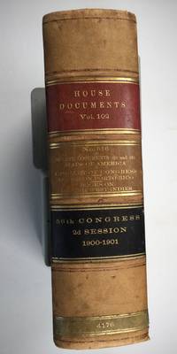
1901025183Washington: Government Printing Office 1901. SEE PHOTOS. A handsome example of the 1901 first edition in quite scarce original leather binding with 3 titles bound together as sometimes seen -- NOT print on demand edition or modern reprint. Very Good condition. NOT a library discard. NO owner's name or bookplate. Hinges are perfect. Minor offset as usual from the leather binding to edges of the endpapers. Front free endpaper has light soil and 4 small edge chips. Pages are otherwise clean and unmarked. NO foxing. 1901. First Edition. 1137pp. Bound in the original full leather calf binding we say "original" because we have seen other first editions in an identical leather binding including its 3 attractive leather spine labels -- in red black and brown -- although none of them were in condition as nice as this one. Leather is only moderately rubbed. SEE PHOTOS. All gilt stamping is still bright and shiny. This is House of Representatives Document No. 516 1901. Also bound in are: A LIST OF BOOKS WITH REFERENCES TO PERIODICALS ON PORTO RICO by A. P. C. Griffin. Senate Document No. 222. 55pp. 1901.; and A LIST OF BOOKS WITH REFERENCES TO PERIODICALS ON THE DANISH WEST INDIES by A. P. C. Griffin. Senate Document No. 223. 18 pp. 1901. Oversize Hardcover. 7.25" wide by 10.25" tall by 3" thick. This large heavy book will require extra postage for Priority and International shipments but only the standard charge for media mail. Sheehy 1986 CL287: "Lists maps to be found in books and atlases as well as those separately issued. Describes many old state and country maps and city plans.". First Edition. Oversize Hardcover. Very Good condition. Illus. by NOT a library discard. 1137pp. 55pp. 18pp. Great Packaging Fast Shipping. Government Printing Office Hardcover
1906Map 753Sampson Low Marston & Co. Ltd. 1906. 2nd Edition . No Binding. Fine. 67x106 cms. 42 x 26 inches. A large folding map laid on linen. The first issue of the map was 1902 and this is the second edition. The Franco-British Exhibition site is included on what became White City and covered 140 acres. The tube lines are updated and include approved and those under construction. A beautifully coloured map in green red and blue. The tube lines are inserted onto a geographical map. It covers a wide area of London and the Home Counties. Unfaded colour and in fine condition. Some folds a trifle split but not worn. The map folds to be enclosed in the original pictorial boardswhich is complete and sound but a trifle foxed and faded. PLEASE EMAIL FOR PHOTOS. <br/> <br/> Sampson Low, Marston & Co. Ltd. unknown
1806Map954Paternoster Row London: Longman Hurst Rees & Orme 1806. 1st Edition 1st Printing. No Binding. Fine. Original early 19th century map MAP OF ASIA BY AARON ARROWSMITH.A FINE CLEAN AND DARK IMPRESSION. Original folding plate printed on heavy paper A scarce example and in fine un-coloured original condition. An occasional light foxing mark. 41x27cms. Double-page folding map. Engraved by Edw. Jones.A LOVELY COPY. Imprint date May 6th 1806. <br/> <br/> Longman, Hurst, Rees & Orme unknown
1805Map947Paternoster Row London: Longman Hurst Rees & Orme 1805. 1st Edition 1st Printing. No Binding. Fine. Folio - over 12 - 15" tall. Original early 19th century uncoloured MAP OF HINDOOSTAN BY AARON ARROWSMITH. A FINE CLEAN AND DARK IMPRESSION. Original folding plate covering THE WHOLE OF HINDOOSTAN printed on heavy paper dated 1808. A scarce example and in fine un-coloured original condition. An occasional light foxing mark. 41x27cms. Double-page folding map. engraved by J. Russell.A LOVELY COPY. paper watermark dated 1811 <br/> <br/> Longman, Hurst, Rees & Orme unknown
1806Map943Paternoster Row London: Longman Hurst Rees & Orme 1806. 1st Edition 1st Printing. No Binding. Fine. Original early 19th century MAP OF THE WORLD On MERCATORS PROJECTION BY AARON ARROWSMITH. A FINE CLEAN AND DARK IMPRESSION. Original folding plate covering THE WORLD printed on heavy paper dated 1807. A scarce example and in fine un-coloured original condition. 41x27cms. Double-page folding map.A NICE COPY <br/> <br/> Longman, Hurst, Rees & Orme unknown
1839TH327London: Longman Orme Brown Green & Longmans 1839. a new Edition Considerably Improved . Hardback. Vg. 8vo. ND but preface dated Walworth 1839. xxiv 364pp 7 folding plates at the rear.12pp pub. cat. dated August 1841 London. Bound in the pub. green fine pebble gren cloth with gilt titles to the spine. Pasted -down end-papers list Longmans 'New School Books'/ Neat owners sig. dated 1842. Thomas Keith 1759-1824. The first edition was pub. in 1805 <br/> <br/> Longman, Orme, Brown, Green & Longmans hardcover
1814Map689Edinburgh: John Thomson 1814. No Binding. Fine. Original hand-colour fine scarce unfolded copy 520 X 650 From John Thomsons New General Atlas 1817 beautifully hand-coloured on thick paper <br/> <br/> John Thomson unknown
1705Map902London: Richard Blome 1705. re-issue . No Binding. Vg. Folio. 50x42cms. Nice dark impression printed on thick paper. Single original plain red ink hand drawn crossing borders to the image edges and repeated in the blank verso. Uncoloured map. Originally engraved by Joseph Moxon in 1660 this later issue of 1705 by Richard Blome has the cartouche and corner engraving removed and rplaced by a compass and pair of dividers. Very wide margins. Joseph Moxn 1627-1699. The map was first designed by Nicolas Visscher. <br/> <br/> Richard Blome unknown
1869Le273London: Trubner & Co. 1869. 2nd Edition . Hardback. Fine. Oblong 4to. 26 Coloured plate maps engraved on copper each with a description. Original brown blind-stamped decorative borders gilt titles. head and tail of the spine rubbed otherwises a fine copy. Karl Spruner von Merz 1803-92 <br/> <br/> Trubner & Co. hardcover
1909014713Albany: University of the State of New York 1909. Original green cloth gilt is in Very Good condition. The book's inner hinges are badly cracked and nearly separated. However since the text block is secure entirely intact it could be easily re-cased without any re-sewing required. Thick 8vo. 234pp. 51pp. 66pp. 41pp. approx. 100 plates inserted. Complete with all of the maps as called for by the table of contents. A tough-to-find book especially complete with all the BEAUTIFUL MULTI-COLOR FOLDING MAPS IN PERFECT CONDITION. Any of them would look magnificent framed. This amazing miscellany contains the Fifth Report to the Director 1908 and Museum Bulletins 126-128 and 133 and Report of the State Paleontologist for 1908. A particularly useful contribution is: One Hundred Years of New York State Geologic Maps 1809-1909 by Henry Leighton. It includes a CARTO-BIBLIOGRAPHY that describes 329 New York Geologic Maps and has its own index. Some other contributions: A Peculiar Landslip in the Hudson River Clays by D. H. Newland; Some Items Concerning a New and an Old Coast Line of Lake Champlain by George H. Hudson; Types of Inliers Observed in New York by Rudolf Ruedemann; The Last of the Iroquois Potters by M. R. Harrington; etc. There are several other articles on the same subjects as and supporting the maps described below. Bound into Museum Bulletin 127 are NINE MULTI-COLOR FOLDING MAPS #34-42: showing 9 stages of Glacial Lake Succession in New York State 1908. In a pocket at the end are SEVEN BEAUTIFUL MULTI-COLOR FOLDING MAPS most by H. L. Fairchild as follows: Museum Bulletin 126: Geologic Map of the Remsen Quadrangles unfolds to 17" wide by 21" tall; Museum Bulletin 127: Plate 2: Channels and Deltas of Ice-Border Drainage between Leroy and Fishers 1906. 39" wide by 17.5" tall; Museum Bulletin 127: Plate 3: Channels and Deltas of Ice-Border Drainage between Irondequoit and Cayuga Valleys 1906. 39" wide by 20" tall; Museum Bulletin 127: Plate 4: Channels and Deltas of Ice-Border Drainage between Jordan and Chittenango Valleys 1906. 36" wide by 20" tall; Museum Bulletin 127: Plate 5: Channels and Deltas of Ice-Border Drainage between Chittenango and Oneida 1906. 17" wide by 12" tall; Museum Bulletin 128: Geologic Map of the Geneva-Ovid Quadrangles 17" wide by 38" tall; Museum Bulletin 128: East-West Section on Ovid and Genoa Quadrangles. Showing the Low Synclines of the Lake Basins. 17" wide by 8" tall. This copy has the small ink stamp of C. Wesley Yeakel in 4 places. First Edition. Hardcover. VG inner hinges cracked/No jacket. Illus. by Fairchild H. L. maps. Thick 8vo. University of the State of New York Hardcover
1830Le601London: G.G. and J. Robinson 1830. 3rd Edition . Hardback. Vg. 8vo. :Containing a Comprehensive System of Modern Geography After a New and Curious Methodlxiii 567 viii pp appendix. Original full plain calf gilt ruled compartments. 5 engraved plates in the Introduction A double hemisphere world map worn but complete as a frontis. and 6 folding maps Europe creased in the main section. "Corrected and considerably enlarged". New descriptions of America and Cook's Voyages I. A General View of the Terraqueous Globe: Being a Description of the Figure Motion and Magnitude of the Earth; The Theory of the Air Winds and Tides; the Doctrine of the Sphere; the Use of the Globes etc etc. II. A particular View of the Terraqueous Globe: Being an accurate Description of all the Empires Kingdoms States Provinces and Colonies in the known World; shewing the Extent of their Situation Extent Climate Air Soil Animal Vegetable and Mineral Productions . To which is added An Appendix: Containing a Geographical Table with the Names and Situations of the Chief Cities Towns &c. etc etc.The first edition of this educational book was <br/> <br/> G.G. and J. Robinson hardcover
1704TH254London: printed for John Nicholson and Samuel Ballard 1704. The Seventh Edition . Hardback. Fine. 12mo. Being a geographical index. Of all the considerable cities patriachships. in Europe. The seventh edition corrected and very much enlarged with the addition of a table of births marriages &c. of.Unpaginated.256pp. Both parts present. The second part being The Births marriages etc of all the Kings Princes and Potentates of Europe. Original full calf binding with panelled polished calf boards and attractive decoration to the corners of the outer panel. Robbed to the extremities but a nice copy. PLEASE EMAIL FOR PHOTOS. <br/> <br/> printed for John Nicholson, and Samuel Ballard hardcover
1716Pa888London: John Nicholson and Samuel Ballad 1716. eleventh edition . Hardback. Vg. 12mo. ii pubs. ad. including maps and atlases by Herman Moll. i pp ad Preface incl. The Clavis i pp vi Gazetteer a5-Ll5; iii pub. book lists.; bound with the Second Part THE GAZETTEER'S OR NEWMAN'S INTERPRETER Being a Geographical Index .in Asia Africa and America pub. by George Sawbridgeand Maurice Atkins London the third edition Corrected and Enlarged 1710 Preface iv Or Divers Measures iii The Clavis i pp The Gazeteer A6- M5 pub. ads iii pp. Original full calf with raised bands. Single gilt ruled borders to the boards. <br/> <br/> John Nicholson and Samuel Ballad hardcover
1758T370Dublin: John Exshaw Dame Street 1758. No Binding. Fine. 8vo. 427-480pp. A disbound copy of the Dublin version of the Gentleman's Magazine for the month of August 1758. Fine fresh paper with no foxing wear or marks. The title-page lists 24 articles on the title-page and includes a fine copy of the rare 'A PLAN of the Harbour and TOWN of LOUISBOURG in the Island of CAPE BRETON Drawn on the Spot. Folding page 28 x 20 cms with a plate impression 24 x 18 cms.4 page description of the plan and town. Other articles include an estimate of the Naval Debt; Part of the trial of William Barnard; Journal of the Seige of Louisbourg; General Abercromby's Account of the Exped. to Crown Point. Single page map of 'The Country between CROWN POINT and ALBANY being the Great Pass from the English to the French Settlements in North America'.11.5 x 19.1 cms. Please email for photos. <br/> <br/> John Exshaw, Dame Street unknown
185275869Oregon City: Surveyor General's Office 1852. First edition. 15 3/4 x 26 inches. Printed in various shades of green blue red and black. Some light toning long fold-lines else a very good map of a vastly underpopulated Territory.The map above shows the surveyed portion of the Oregon Territory as of October 21 1852. It was prepared by John B. Preston first surveyor general of Oregon."With the establishment of the Oregon Territory on August 14 1848 all grants of claims of land in the territory were nullified. It was not until the passage of the Donation Land Act on September 27 1850 that new provisions were made for acquiring unclaimed land to be based upon government surveys. John B. Preston was appointed first surveyor general of Oregon where he arrived on April 20 1851. On June 7 1851 Preston drove the “starting stake†for the base surveys of the territory at what is today known as the Willamette Stone. The east-west Willamette Base Line and the north-south Willamette Meridian still define surveying and legal land descriptions in Oregon and Washington state.Preston and his crew were able to carry out their surveying and mapping to the extent depicted on this map in just over one year. Each square of the grid termed a section is one mile on each side and includes 640 acres of land—the maximum acreage allowed for a married couple making a claim under the Donation Land Act; a single man could claim up to 320 acres. Thirty-six sections make up a township.The surveyors took careful note of waterways hills prairies and roads. Some recognizable places are already viable communities such as Salem and Lafayette; other communities of the period—Champoeg Fairfield Cincinnati for example—have vanished as meaningful places. All three of those were river landings that were affected by floods channel changes and the eventual disappearance of river transportation. Notably absent from the map is Mission Bottom or Mission Landing the by-then-abandoned site of the Methodist mission of the 1830s and St. Paul on French Prairie. The roads that are mapped include ancient routes such as the California-Oregon Trail which had sections that paralleled both sides of the valley as well as newer roads established in recent years. The roads converging on Salem from the outlying farming districts for instance reflect its recent importance as a mill town powered by the waters of Mill Creek Surveyor General's Office unknown
195282192Minneapolis:: Printed for the Author by the Voyageur Press 1952. First edition; one of Sixty Copies Printed. Two looseleaf albums . Generally fine. 8vo. A comprehensive album for collecting postage stamps featuring maps from around the world with spaces to affix specimens and information about each stamp. In this example there are approximately 150 affixed stamps and 133 blank spaces for stamps. Printed for the Author by the Voyageur Press, unknown
1705Map901London: Richard Blome 1705. re-issue . No Binding. Vg. Folio. 50x42cms. Nice dark impression printed on thick paper. Single original plain red ink hand drawn crossing borders to the image edges and repeated in the blank verso. Uncoloured map. Originally engraved by Joseph Moxon in 1671 this later issue of 1705 by Richard Blome has the cartouche and coats of arms and lower engraving re-engraved and the lower part of the plate removed and replaced with a irnage of small hills! The Jonas and his whale engraving has also been re-engraved at the centre top of the image. Now measuring 27x45cms. Very wide margins. Joseph Moxn 1627-1699. The map was first designed by Nicolas Visscher. <br/> <br/> Richard Blome unknown
1799Map913London: G.G.& J. Robinson Paternoster Row 1799. Original Map . No Binding. Fine. Folio. Folding folio map of Asia with outline hand-colour. An attractive map of Asia at the end of the eighteenth century probably engraved by Thomas Kitchen. Nice hand-coloured to the boundaries of the countries stretching from Arabia to Japan and down to Java and New Guinea Nice wide margins 38 x 47.5 cms. image 34 x39 cms. This large scarce map appeared in several publicatons including Clement Cruttwells 1799 Atlas. see House of Commons Map Collection. PLEASE EMAIL FOR PHOTOS <br/> <br/> G.G.& J. Robinson, Paternoster Row unknown
1814Map705Edinburgh: John Thomson 1814. 1st Edition . No Binding. Fine. Original hand-colour fine scarce unfolded copy one edge sl. stain 470 x 520 From John Thomsons New General Atlas 1817 beautifully hand-coloured on thick paper <br/> <br/> John Thomson unknown
1794025454Hartford Connecticut: Elisha Babcock 1794. Good - Very Good condition. SEE PHOTOS. Hinges are sound with only a single half inch hairline crack. NOT a library discard. NO owner's name or bookplate. Foxing mostly light to moderate to several pages. Slight age toning. Bound in full leather sprinkled calf with 5 raised spine bands. Brown leather spine label mostly chipped away. Gilt spine decorations and gilt double ruled borders on the front and rear covers. Handsome gilt inside dentelles i.e. borders decorated with gilt lacy pattern at inner edges. SEE PHOTOS. Frontispiece portrait of the author engraved by Amos Doolittle. This copy includes plates 1 2 4 5 6 8 also engraved Amos Doolittle. Of these 6 plates 5 are folding some copies have only 3 plates that are folding. Plate 1 is a map of New Haven and Its Environs Wheat 281. Plate 4 shows 3 maps one of which shows Hadley Mass Wheat 276 278 280. Plate 5 is a map of the City of New Haven Wheat 275. Plate 8 is another map of Hadley Massachusetts Wheat 279. Lacks pages 145-156 plates 3 and 9 which apparently were not bound in. Plate 7 does not exist in any copy per Howes and Sabin: "there is no plate 7 in any of the copies seen and it is probable none was made." This is a history of three members of the tribunal which had Charles I beheaded in 1649. The author Ezra Stiles was president of Yale College from 1778 until his death in 1795. No errata slip is present in this copy so presumably it is Howes' second issue. Includes the "Advertisement" at the end on an unnumbered page that offers subscribers the option to cancel if dissatisfied with the change in the dimensions of this book from what was described in the prospectus not present. Full title: "A history of three of the judges of King Charles I. Major-General Whalley Major-General Goffe and Colonel Dixwell: Who at the Restoration 1660 fled to America; and were secreted and concealed in Massachusetts and Connecticut for near thirty years. With an account of Mr. Theophilus Whale of Narragansett supposed to have been also one of the judges." Howes S-999. Evans 27743. Sabin 91742. Trumbull Connecticut 1425. ESTC W20469. Church 1264. Wheat and Brun 275-283. First Edition Second Issue. Hardcover. Good - Very Good condition. Illus. by NOT a library discard. 12mo. 358pp. "Advertisement". Great Packaging Fast Shipping. Elisha Babcock Hardcover
1806Map952Paternoster Row London: Longman Hurst Rees & Orme 1806. 1st Edition 1st Printing. No Binding. Fine. Folio - over 12 - 15" tall. Original early 19th century uncoloured MAP OF THE SWITZERLAND BY AARON ARROWSMITH. A FINE CLEAN AND DARK IMPRESSION. Original folding plate covering HOLLAND printed on heavy paper dated 1807. A scarce example and in fine un-coloured original condition. An occasional light foxing mark. 41x27cms. Double-page folding map. engraved by COOPER.A LOVELY COPY. paper watermark dated 1808 <br/> <br/> Longman, Hurst, Rees & Orme unknown
1816Map682Edinburgh: John Thomson 1816. 1st Edition . No Binding. Fine. Original hand-colour fine scarce unfolded copy small damp stain to top margin 510 X 610 From John Thomsons New General Atlas 1817 beautifully hand-coloured on thick paper <br/> <br/> John Thomson unknown