Braun, Georg - Hogenberg, FransAntiquariat.de

5 783 résultats
60339BBo.J. Frans Hogenberg (oder Hooghenbergh, auch Franz Hogenberggeboren 1535 in Mechelen, gestorben 1590 in Köln. Kupferstecher und Radierer. Georg Braun, geboren 1541 in Köln, gestorben 1622 ebenda. Theologe, Kanoniker. Braun und Hogenberg waren in den Jahren von 1572 bis 1618 Herausgeber des Städteansichtenbuches 'Civitates Orbis Terrarum'. [2 Warenabbildungen]
L'INDIA DI QUA' E DI LA' DAL GANGE OVE SONO GLI STATI DEL G. MOGOL.DATA IN LUCE DA G. GIACOMO DE ROSSI IN ROMA 1683.[Veduta] (cm. 59,5 x 46) Rara carta incisa in rame con cartiglio in alto a destra. Alcuni confini leggermente colorati d'epoca. Bell'esemplare con ottimo restauro per rinforzo alla piega centrale e piccola integrazione agli angolini bianchi.[f18] Libro
196725514ABDietikon-Zürich, Bibliophile Drucke von Josef Stocker, 1967. 4°. 56 Blätter mit Teilkarten (49 zu ca. 30 x 30 cm. und 7 zu ca. 30 x 8 cm.) und 1 Übersichtsraster. Begleitheft: 25 (3) S. Mit zahlr. Abbildungen. In Holzkiste. + Wichtig: Für unsere Kunden in der EU erfolgt der Versand alle 14 Tage verzollt ab Deutschland / Postbank-Konto in Deutschland vorhanden +, A
1980417075Duisburg, (1595. Reprint Lachen, Coron, 1980). Fol. 57 doppelblattgr. farb. Ktn. 30 Texts. u. 32 S. Erläut., diese auch m. (teils farb.) Vergleichsabb. Insges. 258 faks. S. Blind- u. goldgepr. Ldrbd.
Basilea, 1550 circa. Xilografia, b/n, cm 21 x 32,3 (il foglio). Dalla “Cosmographiae Universalis” (lib. VI – Basileae, Henrichum Petri, 1550), la pag. 274 dell’atlante, come riportato in alto a sinistra, al margine bianco superiore. Edizione latina incisa da H. Petri, con riquadro figurato (cervo o muflone) al verso del foglio. Si vede la punta meridionale della Corsica con segnalata Bonifacio. Il disegno dell'isola, il cui titolo è inserito in un nastro svolazzante che la abbraccia, mostra una semiologia elementare; i rilievi sono rappresentati da vedute prospettiche di mucchi di talpa allineati a catena; i fiumi da un tratto forte; il mare da un tratteggio ondulato con strisce bianche e nere alternate; la vegetazione è simboleggiata da gruppi di alberelli, mentre i centri abitati sono segnalati da prospettini di case e torri. Sebastian Munster (1488 – 1552). Impressione leggermente stanca con lievi tracce di ingiallimento che però non disturbano l’esemplare. Foglio con due leggere pieghe trasversali ma in buono stato di conservazione.
ORTELIO ABRAMO (Anversa, 1527 - 1598) SCHLAVONIAE, CROATIAE, CARNIAE, ISTRIAE, BOSNIAE, FINITIMARUMQUE REGIONUM NOVA DESCRIPTIO, AUCTORE AUGUSTINO HIRSVOGELIO. , 1592 ca., Buono (Good) Buon es., piega al centro. acquaforte <br> cm. 46 x 33,5 <br> <br> <br>
RARE LIMITED EDITION - COPY #95 OF 500. Reprint of a 16th century Atlas displaying maps of the four known continents: Europe, Africa, Asia and America. The book itself is a portfolio of 26 folded maps of various regions, complete with floral and figurative decoration. The book features a short preface in English, German and Dutch. 350x225mm. Unpaginated. Black cloth Hardcover with cloth straps. Cover slightly worn and slightly dirty. Rear cover edge bumped. Rear cover corners bent. Pages yellowing. [SUMMARY]: Save for some light external wear, this rare reprint of an historical atlas is in very good condition. PLEASE NOTE: This item is overweight. We may ask for extra shipping costs.
1850140962Gotha, Justus Perthes 1850 In-4à l’italienne 23,5 x 31 cm. Reliure demi-basane havane, dos lisse muet, 24 planches, table. Reliure défraîchie avec manque angulaire, coupes usées, intérieur correct. En l’état.
1805Map947Paternoster Row London: Longman Hurst Rees & Orme 1805. 1st Edition 1st Printing. No Binding. Fine. Folio - over 12 - 15" tall. Original early 19th century uncoloured MAP OF HINDOOSTAN BY AARON ARROWSMITH. A FINE CLEAN AND DARK IMPRESSION. Original folding plate covering THE WHOLE OF HINDOOSTAN printed on heavy paper dated 1808. A scarce example and in fine un-coloured original condition. An occasional light foxing mark. 41x27cms. Double-page folding map. engraved by J. Russell.A LOVELY COPY. paper watermark dated 1811 <br/> <br/> Longman, Hurst, Rees & Orme unknown
1806Map943Paternoster Row London: Longman Hurst Rees & Orme 1806. 1st Edition 1st Printing. No Binding. Fine. Original early 19th century MAP OF THE WORLD On MERCATORS PROJECTION BY AARON ARROWSMITH. A FINE CLEAN AND DARK IMPRESSION. Original folding plate covering THE WORLD printed on heavy paper dated 1807. A scarce example and in fine un-coloured original condition. 41x27cms. Double-page folding map.A NICE COPY <br/> <br/> Longman, Hurst, Rees & Orme unknown
1839TH327London: Longman Orme Brown Green & Longmans 1839. a new Edition Considerably Improved . Hardback. Vg. 8vo. ND but preface dated Walworth 1839. xxiv 364pp 7 folding plates at the rear.12pp pub. cat. dated August 1841 London. Bound in the pub. green fine pebble gren cloth with gilt titles to the spine. Pasted -down end-papers list Longmans 'New School Books'/ Neat owners sig. dated 1842. Thomas Keith 1759-1824. The first edition was pub. in 1805 <br/> <br/> Longman, Orme, Brown, Green & Longmans hardcover
1814Map689Edinburgh: John Thomson 1814. No Binding. Fine. Original hand-colour fine scarce unfolded copy 520 X 650 From John Thomsons New General Atlas 1817 beautifully hand-coloured on thick paper <br/> <br/> John Thomson unknown
Very Good German Original color map on cloth of Constantinople, the Bosphorus, the Golden Horn, Princess' Islands, Pera, Galata, Scutari and environment. Map on cloth. 50x60 cm. Toponyms are in German entirely. Folded. Scale: 1:100000. A detailed toponyms list titled "Verzeichnis der mit Ziffern bezeichneten öffentlichen Gebaude" under the sections A: Pera und Galata, B: Stambul, C: Skutari; and "Erlauterung der Abkürzungen". Some toponyms are transcripted Turkish into western characters like Karadenis - Bahr-i Siach, Burgas Adassi, Kisil Adalar, Jeni Djami, etc. A rare Istanbul map printed in 19th century.
1705Map902London: Richard Blome 1705. re-issue . No Binding. Vg. Folio. 50x42cms. Nice dark impression printed on thick paper. Single original plain red ink hand drawn crossing borders to the image edges and repeated in the blank verso. Uncoloured map. Originally engraved by Joseph Moxon in 1660 this later issue of 1705 by Richard Blome has the cartouche and corner engraving removed and rplaced by a compass and pair of dividers. Very wide margins. Joseph Moxn 1627-1699. The map was first designed by Nicolas Visscher. <br/> <br/> Richard Blome unknown
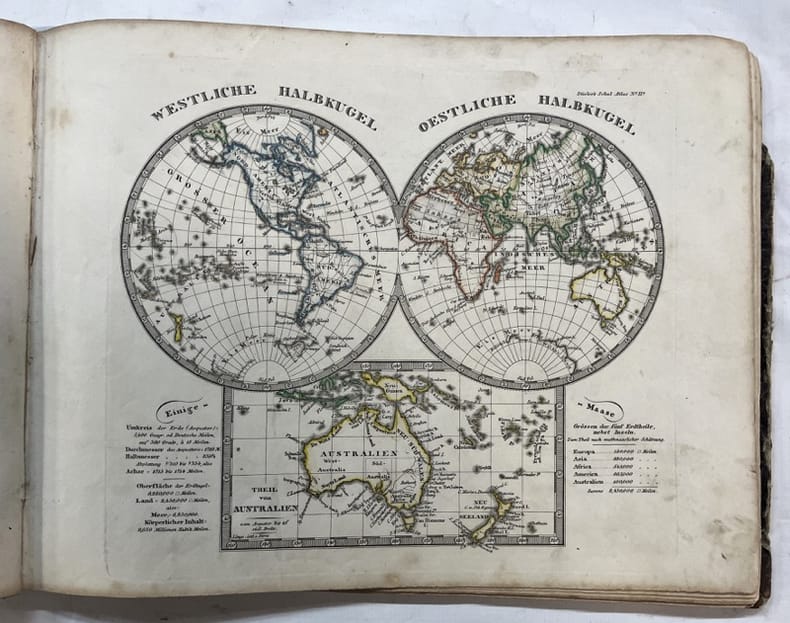
1869Le273London: Trubner & Co. 1869. 2nd Edition . Hardback. Fine. Oblong 4to. 26 Coloured plate maps engraved on copper each with a description. Original brown blind-stamped decorative borders gilt titles. head and tail of the spine rubbed otherwises a fine copy. Karl Spruner von Merz 1803-92 <br/> <br/> Trubner & Co. hardcover
18943000DBBasel, 1894. Gr.-Folio. 1 Titelblatt, Uebersichtsplan, 9 farbige Tafeln und dem dazugehörenden Beiheft mit 19 S. Beiheft leicht fleckig. Papiermappe mit Einrissen. + Wichtig: Für unsere Kunden in der EU erfolgt der Versand alle 14 Tage verzollt ab Deutschland / Postbank-Konto in Deutschland vorhanden + Brochiertes Heft und Papiermappe. Mitteilungen der historischen und antiquarischen Gesellschaft zu Basel. Neue Folge IV.
Pianta di Milano (cm. 31,6 x 40), inc. in rame, montata su tela e suddivisa in 8 riquadri: sul lato sinistro e destro sono riportati i dati relativi alle Chiese (Parrocchiali e sussidiarie) e agli Stabilimenti primarj con il Nome e la relativa ubicazione. Lieve alone al margine del lato destro, altrimenti ben conservata.
grande carta di Parigi (cm 90x62) in cartellina cartonata in 16° - indiquant tous les changements, dessiné par narat -26 piccole incisioni nel riquadro, strappo marginale ricongiungibile e restaurabile
19893828DBLangnau am Albis., Dorfpresse Langnau., (1989). 14 gerollte Karten (mehrfarbig), 48 x 70 cm. In illustrierter Box. + Wichtig: Für unsere Kunden in der EU erfolgt der Versand alle 14 Tage verzollt ab Deutschland / Postbank-Konto in Deutschland vorhanden +, Abb. Masstab 1:25000 - Faksimileausgabe. Deckelboden von Schachtel fehlt. Deckel oben mit Schadstellen. Sonst gutes Exemplar.
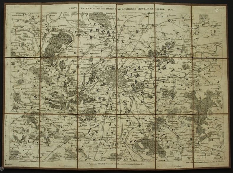
1830140501830 P., chez Auvray, 1830, 1 carte gravée et découpée en 18 parties collées sur une toile (395 x 287 mm dépliée, 93 x 65 mm repliée). Petites déchirures aux pliures, très bel état.
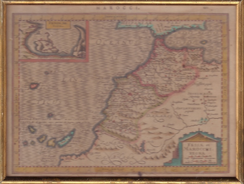
ORD-1849Sans nom d'auteur, d'éditeur et sans date, sans doute vers 1600. Carte de ca 257 x 192 mm (à la cuvette) mention MAROCCI. et le nombre 662 au dessus de la carte. Vue de Penon de Velez dans un rectangle réservé en haut et à gauche de la carte, cartouche rectangulaire placé à l'intérieur d'une construction mauresque en silhouette. Coloris apparemment d'époque, texte en latin imprimé au verso. Encadrement ancien de baguette dorée. Bel exemplaire.
162016204Carte gravée sur cuivre (cuvette 38 x 49 cm environ), non identifiée ; probablement Blaeu ou Hondius à Amsterdam, circa début XVIIe siècle, coloris et gommage d'époque.
ORD-7863Carte couleurs dessinée à la main à l'échelle 1/5000e, accompagnée de notes manuscrites, signées par le Lieutenant de Vaisseau Léon CHAMBEYRON, datée de août 1863. Grande feuille de 242 x 385mm, la carte occupant la partie supérieure et le texte la partie inférieure. Travail de vers marginal affectant seulement 4 lettres, document un peu sali sur les bords. Il s'agit sans doute d'une page originale des instructions nautiques que CHAMBEYRON fit paraître à partir de 1867.
1796644DGWien, ca. 1796. Kolorierte Kupferstichkarte. Plattengrösse: 24 x 31 cm. + Wichtig: Für unsere Kunden in der EU erfolgt der Versand alle 14 Tage verzollt ab Deutschland / Postbank-Konto in Deutschland vorhanden +, Bild
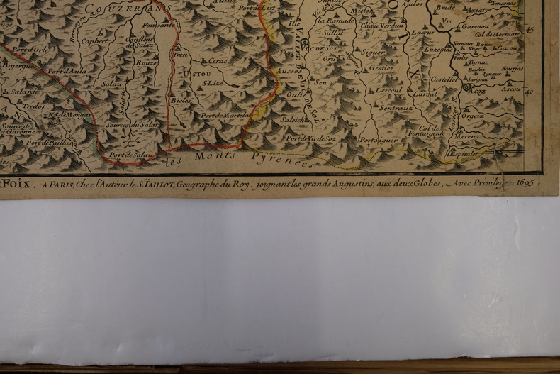
CARTE2T101695, à Paris chez l'Auteur. 65x47cm (marges à ras). Carte réalisée par Jaillot. Épreuve originale de 1695 tirée de l'Atas François. Colorisation des limites datant de l'époque. Deux restaurations au coin gauche de la marge supérieure. Pliure verticale au milieu de la feuille. Brunissure normale. Charmant exemplaire