5 783 résultats
31.5x41 cm. 152 pages. Hardcover with dust jacket. Cover corners slightly rubbed. Else in good condition. PLEASE NOTE: This item is overweight. We may ask for extra shipping costs.
London, 1802, mapa grabado en cobre, suavemente coloreado a mano, de 23'5 x 19 cm.
Very Good German Original color lithograph maps in 7 special cloth cases. Cases large 8vo., only seventh one is smaller which is covered by European marbling. Bookseller and bibliothek stamps on some maps, plans and sketches; and cases interior. A fine map collection. Contents: V.1: Includes 1 map, 2 plans and 5 skecthes, 1 uebersichtskarte. Uebersichtskarte für die Geschichte des Iten und IIten schlesisschen Krieges von 1740-1745. Kriege Friedrichs des Grossen. 1/740000. 73x81 cm.; Plan zur Erstürmung von Glogam am 9 Marz 1741 (Entworfen nach alten Planen). 1/6250 / 1/100000. 48x52 cm; Plan der Schlach bei Mollwitz am 10 April 1741. 1/25000. 43x59 cm.; (Skizze) Stellung der preussischen und oesterreichischen Truppenam, 3 Januar 1741. 1/740000. 30x30 cm.; Skizze zum Scharmützel bei Ellguth und zum Gefecht bei Ottomachall am 9. Januar 1741. 1/67500. 34x26 cm.; Skizze zu den Winterquartieren des preussen mit Stellung der Truppen am 20 Februar 1741. 1/740000. 46x52 cm.; Skizze zum Ueberfall bei Baumgarten am 27 Feb. 1741. 1/50000. 29x34 cm.; Marsch der oesterreichischen Armee unter F. M. Neipperg und der preussischen Truppen unter dem Könige von der Schlacht bei Mollwitz. 1/1480000. 36x42 cm.; [.] Standorte des preussischen Heeres bei Ausbruch des Krieges 1740. 1/2400000. 34x55 cm.; V.2: 12 pieces: 3 uebersichtskarten, 2 planen, 7 skizzen. ... von Europa im Jahre 1756. 1/18000000. 33x46 cm.; ... des südöstlichen Kriegsschauplatzes. 1/740000. 65x95 cm.; Standorte des preussischen uns sachsischen Heeres und Stellung des oestreichischen Truppen in Böhmen, Mahren, oestrç Schlesen und Erzth. oesterreich var Beginn des siebenjahrigen Krieges. 1/2200000. 56x72 cm.; Plan der Schlacht bei Lobositz am 1. Oktober 1756. Verlauf des Schlact bis etwa 12 Uhr Mittags. 1/25000. 47x60cm (Also includes Plan der 2ten Attacke des preussischen Kavallerie and Skizze des beiderseitigen Vormarsches am 30ten September 1756).; ... Weiterer Verlaufdes Schlact bis etwa 3 Uhr Nachtmittags. 1/25000. 47x60 cm.; Skizzen: 1. Vormarssch 28. 8 bis 10.9.56. 2.-3. Pirna 1.10.56. 4. Bewegungen Schwerins 56. 5. Pirna 10.10.56. 6. Pirna 12.10.56. 7. Pirna 13.10.56. V.3: 5 skizzen (No: 8-12) und 3 plannen (No: 3, 4-A, 4-B). Plan 4-A-4-B: Prag, 6.5.1757.; Plan 3: Reichenberg, 21.4.57. Skizze 8: Postrungen und Winterquartiere Dezember 56 (Huge size).; Versammlung der Heere, Marz und April 57.; Einmarsch bis 30.4.57.; Stellungen am 1.5.57.; Stellungen am 5.5.57. V.4: Karten 1,2,3,5 (4 is missing); skies 31,32; uebersichtskarte 5; Plan 12-B. ... des nordöstlischen Kriegsschauplatzes (Huge size).; Skizze 31: Heeresbewegungen vom 11.11.57 bs zum Einrücken in die Winterquartiere, Winter 1757-58.; (World War 1): Karte 1: Belgien und nordost-frankreich. Ostpreussen, polen, kurland, Weissrussland.; Galizien und Wolkynien.; Kleinasien , Schweizes Meer, Kaukasien, Kurdistan, Armenien, Aserbeidschan, Arabier, Mittellandisches Meer: Vordasien map. V.5: Sizzen 20-24 - Planen 6-A, 6-B - 9. Planen: Gr. Jagersdorf, 30.8.57.; Jager b. Goerlitz, 31.8.-9.9.57. Moys, 7.9.57.; Breslau, 22.11.57.; Schweidnitz, 24.10-12.11.57.; Skizze 20: Feldzung in ostpreussen Vormarsch des russischen Heeres bis 6.7.57.; 21: Heeresbewegungen vom 6.7.57 bis zur Schlact bei Gr. Jagersdorf. 22: ... nach der Schlact bei Gr.-Jagersdorf bis zum Schluss.; 23: Bewegungen i. d. Lausitz u. i. Schleisen, 20.8.-30.11.57.; 24: Lager bei Liegnitz, 19.-27.9.57. V.6: Plan 5-A, 5-B - Skizzen no: 13-19. Plans: Kolin, 18.6.57.; Kolin, 18.6.57.; Skizzen 13: Beiderseitige Stellungen 8.5.57.; 14: Operationen Beverns u. d. Königs gegen Daun 10.5.-17.6.57.; Bewegungen vom 20.6.-1.7.57. Stellungen vom 1.7.57.; Rechten Elbufer in der ersten Halfte des Juli 1757.; ... vor Zittau, 12.-20.8.57. V.7: 4 plans in cloth covered with European marbling. These last 4 plans from "Suworow und Polens untergang. Nach archivalischen Quellen dargestellt" von Friedrich von Smitt, 1858 First Edition. Pl. 1: Der Schlact am Rymnik den 11/22 Septeember 1789. Pl. 2: ... der
414p. Numerous illustrations. 8vo. Original printed wraps. **PRICE JUST REDUCED! REF4
19901904CBZürich, Meliorations- und Vermessungsamt, 1990. 4°-quer. Titelblatt, Ueberischt und 30 faksimilierte, farbige Kartenblätter. 16 Seiten Dokumentation zur Faksimilierung. Orig. Pappschachtel mit Deckelschild. + Wichtig: Für unsere Kunden in der EU erfolgt der Versand alle 14 Tage verzollt ab Deutschland / Postbank-Konto in Deutschland vorhanden +, A|B [2 Warenabbildungen]
66524Antwerpen , Uitgeverij Luster, 2024 Hardcover, 264 pages, 30.5 x 25 cm, richly illustrated, English text. *new ISBN 9789460583674.
199575321France Loisirs 1995 415 pages in8. 1995. cartonné. 415 pages.
199587879France Loisirs 1995 415 pages in8. 1995. cartonné. 415 pages.
199598687France Loisirs 1995 415 pages in8. 1995. cartonné. 415 pages.
62446, Holland Casino, Ringband; COMPLEET; Inclusief kaartspel en losse bijlage met vertaling in Engels en Duits.
Serie di 9 (su 10) incisioni all'acquaforte di mm 670 x 340 alla battuta su carta di gran corpo. Tutti i foglio a grandi margini in perfetto stato di conserazione. Carta in scala 1:30 000. Magnifica e molto rara opera cartografica sul Corso del Reno, purtroppo mancante dell'ottavo (8) foglio.
59489aafBerlin, Ernst Siegfried Mittler, 1872, in-8vo, 2 Bl. + 86 S. + 2 lith. Figurentafeln, Bibl.-Stempel und hs. Bibl.-Nr. auf Titelbl., Leinenband, vergold. Titel und Bibl.-Nr. auf dem Rücken.
London, The British Library, 1996, 4to quadrato (cm. 27 x 29) tutta tela editoriale con sovraccopertina illustrata a colori, pp. 136 con numerosissime illustrazioni in nero e a colori nel testo. Stato di nuovo.
Roy 4to., First Edition, with numerous fine coloured reproductions and pictorial endpapers; blue cloth, gilt back, a fine copy in unclipped dustwrapper.
4to., SOLE EDITION, with a frontispiece and 9 plates of facsimiles; cloth, covers a little sunned and age-marked, backstrip faded else a very good, clean copy of a scarce work. This outstanding catalogue (compiled by Whitaker of his own collection) was published by the Brotherton Library as 'Library Publications' No. 2. It was never reprinted and is now increasingly hard to find. Sold from an institution with its small, neat stamp on front free endpaper, half-title and title only
First Edition, 4to, frontis., facsimiles, orig. cloth.
4856Folio Society, Londres, 2000. Un volume in-4 reliure de l'éditeur sous étui cartonné illustré, 263 pages, texte en anglais, riche iconographie en couleurs. Parfait état.
1969018432New Haven Connecticut & London: Yale University Press 1969. SIGNED by co-author Christian Brun on the title page his signature only NOT personalized to anyone. Very Good condition. Mild crease to one corner of a few early leaves. NOT a library discard. NO owner's name or bookplate. NO underlining. NO highlighting. NO margin notes. 1969. First Edition. Expertly described here are all separately published maps and charts in America until 1800 as well as those in books pamphlets almanacs magazines atlases and gazetteers. Illustrated with 18 map reproductions frontispiece in color; 1 folding. Bibliography. Index. Bound in the original gilt-stamped blue cloth. 7.75" wide by 10.25" tall. Signed by Christian F. Brun. First Edition. Hardcover. Very Good condition/No jacket. xxii 215pp. 18 plates . Great Packaging Fast Shipping. Yale University Press Hardcover
MASTER361054IParsippany NJ.: Maurizio Martino. VG In Green Cloth With Gilt Lettering. 5 Books In 6 Volumes Complete. Oversize. All Pages Clean Bindings Tight. Pub. 1995 Reprint Of 1957 I.H.C. Edition. Pages: 1378. Undated. Reprint. Hardcover. Maurizio Martino hardcover
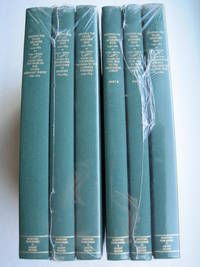
1995018762Storrs-Mansfield CT / Parsippany New Jersey: Martino Fine Books / About Books 1995. 6 separate volumes complete 5 volumes bound in 6 books WITH LARGE FOLD-OUT MAPS -- just like the first edition. SEE PHOTOS. Each of the 6 books in this 1995 large format edition measures 9.25" wide by 12.25" tall. This is NOT the later smaller format 3-volume reprint in which the maps are reduced in size. Unlike later reduced-size editions the maps in this 1995 six-volume edition measure as large as 21" by 33" when unfolded. SEE PHOTOS. As original co-publisher we are pleased to offer the few remaining sets of the 1995 large-format 6-volume edition recently rediscovered in our warehouse. They are BRAND NEW in perfect condition. STILL SEALED in the publisher's clear plastic SHRINKWRAP and the PUBLISHER'S CARDBOARD SHIPPING BOX. NO rubbing. NO fading. Bright clean square and tight. NO owner's name or bookplate. NOT a remainder. Fresh and crisp -- obviously never read. No date but 1995 First Martino/About Books printing "strictly limited to 350". Reprint of the original 1957-1963 six separate volumes: xiv 264; xiii 281; xiii 349; xiii 260; xix 222; iv 223-487pp. MAPPING THE TRANSMISSISSIPPI WEST is a monumental and exceptionally thorough work that is unlikely to be surpassed. The set is illustrated with a total of 376 maps including several that fold out. In this standard carto-bibliography are full descriptions of some 1300 maps from the year 1540 to about 1880. Wheat discusses each map showing the origins of its date and weighing its significance and accuracy. He also identifies the atlases and books in which the maps can be found. Norman Thrower: "Scholars and others who are interested in the American west have found Wheat's work indispensable." Ristow 382: "A comprehensive cartobibliography with many fine reproductions." The 6 volumes are uniformly bound in the original gilt-stamped green cloth. SEE PHOTOS. Oversize Hardcover. All 6 volumes measure 9.25" wide by 12.25" tall. This heavy set will require extra postage for Priority and International shipments. But for media mail you pay only our standard charge for 1 volume and we ship the other 5 volumes at no extra cost. First Martino/About Books printing. Oversize Hardcover. New/in publisher's shrinkwrap. Illus. by We ship all 6 volumes for cost of 1. 6 volumes: 9.25" wide by 12.25" tall. Great Packaging Fast Shipping. Martino Fine Books / About Books Hardcover
1995018771Storrs-Mansfield CT / Parsippany New Jersey: Martino Fine Books / About Books 1995. Vol. 5 Part I only of 6 separate books. As original co-publisher we are pleased to offer the few remaining individual volumes from our 1995 large-format 6-volume edition that were recently rediscovered in our warehouse. Oversize Hardcover. 9.25" wide by 12.25" tall. This volume is NOT from the later smaller format 3-volume reprint in which the maps are reduced in size. Offered here is Vol. 5 Part I only Vol. 5 was issued in 2 separate books. It is BRAND NEW in perfect condition. NO rubbing. NO fading. Bright clean square and tight. NO owner's name or bookplate. NOT a remainder. Fresh and crisp -- obviously never read. No date but 1995 First Martino/About Books printing "strictly limited to 350". Vol. 5 Part I only. Reprint of the 1963 Institute of Historical Cartography original. MAPPING THE TRANSMISSISSIPPI WEST is a monumental and exceptionally thorough work that is unlikely to be surpassed. In this standard carto-bibliography are full descriptions for hundreds of important maps 1861-1867. Many are illustrated on full page plates 9.25" wide by 12.25" tall. Wheat discusses each map showing the origins of its date and weighing its significance and accuracy. He also identifies the atlases and books in which the maps can be found. Norman Thrower: "Scholars and others who are interested in the American west have found Wheat's work indispensable." Ristow 382: "A comprehensive cartobibliography with many fine reproductions." Bound in the original gilt-stamped green cloth. This large heavy book will require extra postage for Priority and International shipments but only the standard charge for media mail. First Martino/About Books printing. Oversize Hardcover. New/No jacket as issued. xix 222pp. Great Packaging Fast Shipping. Martino Fine Books / About Books Hardcover
1995018772Storrs-Mansfield CT / Parsippany New Jersey: Martino Fine Books / About Books 1995. Vol. 5 Part 2 only of 6 separate books. As original co-publisher we are pleased to offer the few remaining individual volumes from our 1995 large-format 6-volume edition that were recently rediscovered in our warehouse. Oversize Hardcover. 9.25" wide by 12.25" tall. This volume is NOT from the later smaller format 3-volume reprint in which the maps are reduced in size. Offered here is Vol. 5 Part 2 only Vol. 5 was issued in 2 separate books. It is BRAND NEW in perfect condition. NO rubbing. NO fading. Bright clean square and tight. NO owner's name or bookplate. NOT a remainder. Fresh and crisp -- obviously never read. No date but 1995 First Martino/About Books printing "strictly limited to 350". Vol. 5 Part 2 only. Reprint of the 1963 Institute of Historical Cartography original. MAPPING THE TRANSMISSISSIPPI WEST is a monumental and exceptionally thorough work that is unlikely to be surpassed. In this standard carto-bibliography are full descriptions for hundreds of important maps from 1868 to the 1870s. Many are illustrated on full page plates 9.25" wide by 12.25" tall. Wheat discusses each map showing the origins of its date and weighing its significance and accuracy. He also identifies the atlases and books in which the maps can be found. As this is the final volume it contains a comprehensive index for all 6 books in the set. Norman Thrower: "Scholars and others who are interested in the American west have found Wheat's work indispensable." Ristow 382: "A comprehensive cartobibliography with many fine reproductions." Bound in the original gilt-stamped green cloth. This large heavy book will require extra postage for Priority and International shipments but only the standard charge for media mail. . First Martino/About Books printing. Oversize Hardcover. New/No jacket as issued. iv pp. 223-487. Great Packaging Fast Shipping. Martino Fine Books / About Books Hardcover
1995018317Storrs-Mansfield Connecticut: Maurizio Martino Publisher 1995. 1995 Enlarged edition. BRAND NEW in perfect condition. NO rubbing. NO fading. Bright clean square and tight. Sharp corners. NO owner's name or bookplate. NOT a remainder. Fresh and crisp -- obviously never read. No date but 1995 First Martino printing "strictly limited to 350". This 1995 edition has all the content of the 1942 original plus is updated and enlarged. There is a new introduction by Gary Kurutz that places Wheat's work in historical context and offers information on the book's production and initial reception. Also new are descriptions by Warren Heckrotte of 27 Gold Rush maps or variants that Wheat missed. Another plus is the frontispiece Map of the Southern Mines 1852 which did not appear in the 1942 trade edition but only in 22 deluxe presentation copies. Including the frontispiece there are a total of 27 full-page and double-page map facsimiles. This is an attractively produced book handsomely bound in the original tan cloth stamped in bright red and black over a cream color spine label. Oversize Hardcover. 9.25" wide by 12.25" tall. This large heavy book will require SUBSTANTIAL extra postage for international shipments but only the standard charge for priority or media mail. Updated and Expanded Edition. Oversize Hardcover. New/No jacket as issued. xlii 153pp. plates 262 total pages. Great Packaging Fast Shipping. Maurizio Martino Publisher Hardcover