John Speed (1552-1629)Biblio.com
1 204 résultats
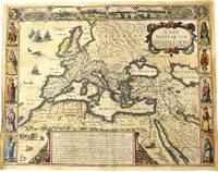
1676M10992London 1676. Very Good. Notes: English text on verso.<br>Map of the Roman Empire it is surrounded by views of the cities of Geneva Rome Jerusalem Venice and Constantinople and Alexandria and figures displaying the customary dress of Italians Egyptians Turks and Spaniards with their wives. <br><br>John Speed 1552 –1629 was an English cartographer and historian. He is known as England's most famous Stuart period mapmaker. His maps of English counties are often found framed in homes throughout the United Kingdom. For a series of maps Speed partnered with Dutch engraver Jodocus Hondius. <br><br> Size : 393x509 mm 15.47x20.04 Inches Coloring: Original Hand Coloring Category: Maps Europe Continent; Maps Asia Continent; unknown
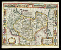
167621929<p>London: and are to be sold by Tho: Bassett in Fleet Street & Richard Chiswell in St. Pauls Churchyard 1676. 395 by 510mm. 15.5 by 20 inches. Speed's map of 'Tartary' Double-page engraved map with hand-colour. A map of Tartary encompassing parts of modern-day Siberia and Central Asia from the 1676 edition of the first atlas compiled and published by an Englishman Speed's 'Prospect'. The decorative border that runs along the top of the map depicts views of major cities as well as the house built on 'Nova Zemla' Novaya Zemlya by the explorer Willem Barentsz and his crew stranded there in 1596 here presented fending off a polar bear. Along each side are illustrated figures in regional costume. Accompanying text in English 'The Description of the Kingdom of Tartary' is printed on the reverse. John Speed 1552-1629 was the outstanding cartographer of his age. By trade a merchant tailor but by proclivity a historian it was the patronage of Sir Fulke Greville poet and statesman that allowed him to pursue this interest in earnest. His 'Theatre of Great Britain' first published in 1611 or 1612 was the first large-scale printed atlas of the British Isles. The 'Prospect of the Most Famous Parts of the World' from which the present work is drawn appeared in 1627 bound with the 'Theatre' and is the first world atlas compiled by an Englishman to be published in England. Engraved in Amsterdam many of the maps are anglicized versions of works by Dutch makers in distinctive carte-à-figure style featuring borders with figures in local costume and city views. This map is from the 1676 edition of the 'Prospect' published by Thomas Bassett and Richard Chiswell. While not as rare as the earlier publications this edition is perhaps the most important given that it is the first to include the nine new maps: among them Virginia and Maryland Barbados and Russia. It is also the last time that the 'Prospect' was printed as an atlas. Shirley Atlases T.SPE-2f.</p> and are to be sold by Tho: Bassett in Fleet Street & Richard Chiswell in St. Pauls Churchyard,
1626273459London: George Humble 1626. unbound. Map. Engraving with hand coloring. Image measures 15.25" x 19.75".<br/><br/> This beautiful carte a figures map of Tartary by John Speed presents the many geography speculations found at a time when parts of Asia were largely unexplored by Europeans. Extends from Armenia eastward to include part of North America and includes the Arctic Sea and Nova Zembla.<br><br>Korea is presented as an Island while the Kamchatka Peninsula is entirely absent. The Straits of Anian believed to be associated with the mythical Northwest Passage is identified. The Great Wall of China is depicted in a grand style south of which lies the Kingdom of China. Throughout several kingdoms important cities rivers lakes islands mountains and other topographical features are noted. These includes important cities which were part of the ancient Silk Route.<br><br>The Caspian Sea presented along its East-West Axis according to the practice of the time is identified by various names Sea of Sala otherwise Bachu called by the Russians Chualenske More in old time the Caspian and Hircan Sea. Further north Tazota Island from the Roman geographer Pliny the Elder appears in the Arctic Circle.<br><br>Beijing or Peking appears north of the Great Wall and is identified by the name Cambalu as used my Marco Polo. Interesting notations are also included throughout including one north of the Great Wall reading "In this Country is a hil out of which they dig earth called by Pliny terra Asbestus having fine veines like grasse which being spun and weaved yeeld cloth that wil nut burn in the fire".<br><br>The map is surrounded on the left and right with illustrations of the costumes and people from various parts of the region. Along the top border four views are included detailing the cities Astrakan Samarkand Cambalu and a view of the house of Nova Zembla.<br><br>Engraved by Dirck Grijp. Appears in Speed's important "Prospect of the Most Famous Parts of the World". The map is in good condition with some wear along the original centerfold. Overall foxing and some tape residue long the top margin from framing. Very good impression. English text verso.<br><br>John Speed 1552-1629 is widely considered to be the most famous English cartographer of the 17th century. His atlas "The Theatre of the Empire of Great Britaine" contained the first set of individual county maps of England and Wales as well as significant town plans that are in many cases the first visual records of their subjects. This important map of Asia is a wonderful example of his work.<br/><br/> George Humble unknown books
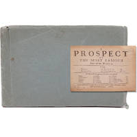
166821680London: Printed for Roger Rea 1668. Third edition. This was first published in 1631. Maps removed they were printed with the text. lacking A2 &7 B5 C2 &8 D5 E2 &8 F5 G2 &7 H5 I2 &8 K4 L1 & 6 M3 &7 and N4 &8. 1 vols. Oblong 24mo 6 1/2 x 4 inches. Later green wrappers some browning of text lacking 21 leaves else a very good copy. Third edition. This was first published in 1631. Maps removed they were printed with the text. lacking A2 &7 B5 C2 &8 D5 E2 &8 F5 G2 &7 H5 I2 &8 K4 L1 & 6 M3 &7 and N4 &8. 1 vols. Oblong 24mo 6 1/2 x 4 inches. The section on America the D gathering is lacking the first and final leaves but the comments on Virginia are present "on the East it has Mare del Nort on the North Norumbega Florida on the South and Westward the bound are not yet set.The North parts are most inhabited by our men and it is therefore called New England." Florida is "'a Pleasant Region.discovered by our English under Sebastian Cubbot 1497 but left for the Spaniard to possess.and after him the French but neither in quiet. For they warred upon each other till they left neither of them men enough to hold it". Sabin 89228n Printed for Roger Rea unknown
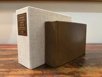
16466182London: M. F. for William Humble/George Humble 1646. First Thus. Very Good. An original travel atlas containing an early map of the world maps of the continents several countries and detailed maps of Ireland Wales Scotland and the counties in England. Bound in modern full grain leather over boards with new endpapers. Housed in a custom clamshell box using archival cloth and with a leather and gilded label on the spine. A few names on first blank in 19th century/early 20th century ink dated. Pages are toned some trimmed very close to the plate. Some infrequent soiling all text and maps are legible. With 1 folding map; a short tear to the folded part of the map. General wear to page edges. Complete with an engraved double-hemisphere map of the world 4 maps of the continents 15 other global maps and 63 maps of England Scotland Wales and Ireland. A 64th map is called out in the table of maps but Midia seems to be missing from all examples. This a miniaturized version of John Speed's folio edition.<br /> <br /> Pages: 4 206; 2; 378 Dimensions: 65/16 x 43/16 x 2. M. F. for William Humble/George Humble unknown
16279025633London: George Humble 1646 and 1627. Hardcover. Very good. Two works in one volume. Oblong octavo measuring 6 1/4 x 3 7/8 inches 16 x 9.75 cm.Rebound in full brown pebbled morocco with new tan endpapers. With custom made drop back folding clamshell slipcase in complementary tan cloth with leather spine labes stamped in gilt. First part with engraved title plus 19 engraved maps as called for. Second part with engraved title bound in upside down and remargined; Sixty - four maps called for in the index. Lacks map of England Scotland and Ireland1 and final map entitled MIDIA 64. Yorkshire map is missing section folded in from fore edge. 81 maps of 83 called for PLUS two engraved title pages. Some interior stains and foxing but still quite acceptable. A series of images is available on request. <br/><br/> George Humble hardcover books
166821680London: Printed for Roger Rea 1668. Third edition. This was first published in 1631. Maps removed they were printed with the text. lacking A2 &7 B5 C2 &8 D5 E2 &8 F5 G2 &7 H5 I2 &8 K4 L1 & 6 M3 &7 and N4 &8. 1 vols. Oblong 24mo 6 1/2 x 4 inches. Later green wrappers some browning of text lacking 21 leaves else a very good copy. Third edition. This was first published in 1631. Maps removed they were printed with the text. lacking A2 &7 B5 C2 &8 D5 E2 &8 F5 G2 &7 H5 I2 &8 K4 L1 & 6 M3 &7 and N4 &8. 1 vols. Oblong 24mo 6 1/2 x 4 inches. The section on America the D gathering is lacking the first and final leaves but the comments on Virginia are present "on the East it has Mare del Nort on the North Norumbega Florida on the South and Westward the bound are not yet set.The North parts are most inhabited by our men and it is therefore called New England." Florida is "'a Pleasant Region.discovered by our English under Sebastian Cubbot 1497 but left for the Spaniard to possess.and after him the French but neither in quiet. For they warred upon each other till they left neither of them men enough to hold it". Sabin 89228n Printed for Roger Rea unknown books
Z1-K-008-01548Longmans Green & Co. Used - Good. 1933. In poor dust wrapper. with colour picture to front. Ships from UK in 48 hours or less usually same day. Your purchase helps support Sri Lankan Children's Charity 'The Rainbow Centre'. Shows some signs of wear but in good overall condition. 100% money back guarantee. We are a world class secondhand bookstore based in Hertfordshire United Kingdom and specialize in high quality textbooks across an enormous variety of subjects. We aim to provide a vast range of textbooks rare and collectible books at a great price. Our donations to The Rainbow Centre have helped provide an education and a safe haven to hundreds of children who live in appalling conditions. We provide a 100% money back guarantee and are dedicated to providing our customers with the highest standards of service in the bookselling industry. Longmans, Green & Co unknown
0265538424.Ghardcover. Good. Access codes and supplements are not guaranteed with used items. May be an ex-library book. hardcover
A9781343732810Hardback. New. hardcover
1343732816.Ghardcover. Good. Access codes and supplements are not guaranteed with used items. May be an ex-library book. hardcover
1373147008.Ghardcover. Good. Access codes and supplements are not guaranteed with used items. May be an ex-library book. hardcover
1377965031.Gpaperback. Good. Access codes and supplements are not guaranteed with used items. May be an ex-library book. paperback
0282750029.Gpaperback. Good. Access codes and supplements are not guaranteed with used items. May be an ex-library book. paperback
25106446like new. unknown
192821459Philadelphia: Lea & Febiger 1928. 2nd edition. 1928. Thick heavy 8vo. xiii 952 pp. 987 figs. Original dark green cloth binding. Bookplates of "Hewitt H. Robinson" and a signature on flyleaf "Marcus B. Gonzalez." Internal hinges slightly cracked else very good. 2nd Edition. Hardcover. Very Good. Philadelphia: Lea & Febiger, 1928. 2nd edition. hardcover
0365355062.Ghardcover. Good. Access codes and supplements are not guaranteed with used items. May be an ex-library book. hardcover
0282629246.Gpaperback. Good. Access codes and supplements are not guaranteed with used items. May be an ex-library book. paperback
22036Longmans Green London 1911. First edition. Coloured frontispiece and plates in b&w. 8vo 8 1/4 x 5 3/4 inches 266-pages. Original blue cloth with applied coloir illustratiom withim gilt rope border as issued. Very good. Inscvribed on front fly "With he Author's best wishes June 1913". Longmans Green, London, 1911. hardcover
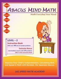
201418025aSAI Speed Math Academy 01/06/2014 00:00:01. paperback. Good. 0.5584 in x 27.9188 in x 21.5736 in. SAI Speed Math Academy paperback
SONG1941589006SAI Speed Math Academy 2014-06-01. 1. paperback. Used: Good. 8.50x0.22x11.00. Buy with confidence. Excellent Customer Service & Return policy. SAI Speed Math Academy paperback
1941589006New. Brand new and still unused unknown
1941589006.Gpaperback. Good. Access codes and supplements are not guaranteed with used items. May be an ex-library book. paperback
1941589030.Gpaperback. Good. Access codes and supplements are not guaranteed with used items. May be an ex-library book. paperback
DADAX1941589006SAI Speed Math Academy 2014-06-01. 1. paperback. New. 8.50x0.22x11.00. Buy with confidence. Excellent Customer Service & Return policy. SAI Speed Math Academy paperback