1 204 résultats
1963151483Tooele County UT: N.p. 1963. Archive of 163 vernacular photographs including 145 in color and 18 in black-and-white capturing the 1960-1963 National Speed Trials commonly known as Speed Week at the Bonneville Salt Flats in Utah. Housed in 17 yellow envelopes with dates and names of racers written in holograph ink annotation to the rectos. <br/><br/>Offered with the archive is a brand new set of the two-volume Bonneville National Speed Trials references covering 1949-1958 and 1959-1968 respectively. The set is new and still in shrinkwrap.<br/><br/>In the early 1960s wealthy California car owners began to experiment with surplus jet engines to boost the horsepower of their cars creating distinctive bootlegged hotrods referred to as jet cars or jets designed specifically for the compacted salt surface of the flats. <br/><br/>The photographs in the archive document many early iterations of these unusual and profoundly dangerous vehicles with a particular focus on racers from southern California including Art Arfons' 8000-horsepower Cyclops which set a record for an open-cockpit vehicle 342 mph which still stands today and Mickey Thompson's Challenger I the first car to record a top speed of 400 mph. Also notable are several photographs of the streamliner entries of the Summers brothers in 1961 1962 and 1963 whose streamliner Goldenrod would go on to hold the land speed record from 1965 to 1991. <br/><br/>As a whole the photographs are bright and well-executed clearly shot with a racing insider's eye for detail. Photographs from the perspective of Speed Week attendees are scarce owing to the relatively remote locale and complete absence of accommodations for spectators making the images in the archive an uncommon intimate record of several pivotal years in the history of hotrod racing.<br/><br/>Photographs 5.75 x 3.5 inches envelopes 7.5 x 4. Some photographs with faint adhesive residue to the versos else envelopes and photographs generally Near Fine.<br/><br/>Full provenance available. N.p. unknown books
1404860444.Glibrary. Good. Access codes and supplements are not guaranteed with used items. May be an ex-library book. unknown
1404863931.Gpaperback. Good. Access codes and supplements are not guaranteed with used items. May be an ex-library book. paperback
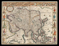
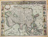
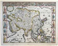
162621912<p>London: Are to be sold in pops-head alley against the Exchange by G. Humble 1626 but 1627-1632. 400 by 510mm. 15.75 by 20 inches. The first English printed map of Asia Double-page engraved map with hand-colour. The first English printed map of the continent of Asia from the first atlas compiled and published by an Englishman Speed's 'Prospect'. The map is heavily influenced by Hondius' 1623 map and inherits the gaps in his geographical understanding of Asia: Korea is presented as a peninsula and an anonymous stretch of water separates Asia from America identified only as a blending of 'The Tartarian Sea' and 'The West Ocean'. In India one finds the mythical 'Lake Ciamay' a common feature of European maps of Asia from the 16th to the 18th c. the imagined source of the major rivers of south-east Asia. The map is not without topographical accuracy however. In China the Great Wall of China is depicted described as 'a bulwarke against the suddaine infall of ye Tartars on this side'. Vignettes in the border at the top of the map depict bird's-eye views of important towns among them 'Goa' and 'Aden'. Illustrated in the borders along the sides of the map are costumed figures. Accompanying text in English 'The Description of Asia' is printed on the reverse. John Speed 1552-1629 was the outstanding cartographer of his age. By trade a merchant tailor but by proclivity a historian it was the patronage of Sir Fulke Greville poet and statesman that allowed him to pursue this interest in earnest. His 'Theatre of Great Britain' first published in 1611 or 1612 was the first large-scale printed atlas of the British Isles. The 'Prospect of the Most Famous Parts of the World' from which the present work is drawn appeared in 1627 bound with the 'Theatre' and is the first world atlas compiled by an Englishman to be published in England. Engraved in Amsterdam many of the maps are anglicized versions of works by Dutch makers in distinctive carte-à-figure style featuring borders with figures in local costume and city views. Chubb XXV; 'Mapping the Continent of Asia' 30; Shirley Atlases T.SPE-2a; Suárez 200.</p> Are to be sold in pops-head alley against the Exchange by G. Humble,
1626M10939London c.1626. Very Good. Notes: English text on verso.<br>First British map of Asia the map has 8 town plans in upper border and costumes of inhabitants of Asia in side borders. Size : 395x514 mm 15.55x20.24 Inches Coloring: Original Hand Coloring Category: Maps Asia Continent; unknown
1627337000London: George Humble 1627. unbound. Map. Engraving with hand coloring. Image measures 15 3/8" x 20".<br/> <br/> This fascinating 1626 map of Asia by John Speed is the first British map of Asia. The map presents the entire continent from the Mediterranean east to include Japan and the East Indies. The map presents many speculations and common conventions found at a time when parts of Asia were largely unexplored by Europeans.<br> <br> Korea is presented as an elongated peninsula while the Kamchatka Peninsula is entirely absent. The map shows Japan and a fairly detailed depiction of the East Indies. Further west the Caspian Sea is presented along its East-West axis as per the practice at the time. The Great Wall of China is depicted in a grand style. Throughout several kingdoms important cities rivers lakes islands mountains and other topographical features are noted.<br> <br> One of the most interesting cartographic feature on this map is the appearance of Lake Ciamay or Lake Chiamay near northeast India. This mythical lake appeared on maps from the 16th to late 18th century and was believed to be the source of the great rivers of Southeast Asia.<br> <br> Illustrations of ships and sea monsters are included. The map is surrounded on the left and right with illustrations of the costumes and people from various parts of the continent. Along the top border eight city views are included detailing Candy Goa Damascus Jerusalem Ormus Bantam Aden and Macao.<br> <br> Engraved by Abraham Goos 1590 - 1643 a master engraver was the son of Pieter Goos and Margareta van den Keere which were both from map families. Appears in Speed's important "Prospect of the Most Famous Parts of the World". The map is in good condition. Archival repair to closed tear at lower margin near centerfold. Minor staining at edges not affecting the image. English text on verso.<br> <br> John Speed 1552-1629 is widely considered to be the most famous English cartographer of the 17th century. His atlas "The Theatre of the Empire of Great Britaine" contained the first set of individual county maps of England and Wales as well as significant town plans that are in many cases the first visual records of their subjects. This important map of Asia is a wonderful example of his work.<br/> <br/> George Humble unknown
1627273306London: George Humble 1627. unbound. Map. Engraving with later hand coloring. Image measures 15.25" x 20".<br/><br/> This fascinating 1627 map of Asia by John Speed is the first British map of Asia. The map presents the entire continent from the Mediterranean east to include Japan and the East Indies. The map presents many speculations and common conventions found at a time when parts of Asia were largely unexplored by Europeans.<br><br>Korea is presented as an elongated peninsula while the Kamchatka Peninsula is entirely absent. The map shows Japan and a fairly detailed depiction of the East Indies. Further west the Caspian Sea is presented along its East-West axis as per the practice at the time. The Great Wall of China is depicted in a grand style. Throughout several kingdoms important cities rivers lakes islands mountains and other topographical features are noted.<br><br>One of the most interesting cartographic feature on this map is the appearance of Lake Ciamay or Lake Chiamay near northeast India. This mythical lake appeared on maps from the 16th to late 18th century and was believed to be the source of the great rivers of Southeast Asia.<br><br>Illustrations of ships and sea monsters are included. The map is surrounded on the left and right with illustrations of the costumes and people from various parts of the continent. Along the top border eight city views are included detailing Candy Goa Damascus Jerusalem Ormus Bantam Aden and Macao.<br><br>Engraved by Abraham Goos 1590 - 1643 a master engraver was the son of Pieter Goos and Margareta van den Keere which were both from map families. Appears in Speed's important "Prospect of the Most Famous Parts of the World". The map is in good condition with some wear and verso repair along the original centerfold. Overall foxing and narrow margins. English text verso.<br><br>John Speed 1552-1629 is widely considered to be the most famous English cartographer of the 17th century. His atlas "The Theatre of the Empire of Great Britaine" contained the first set of individual county maps of England and Wales as well as significant town plans that are in many cases the first visual records of their subjects. This important map of Asia is a wonderful example of his work.<br/><br/> George Humble unknown books
2019x-0367381818Auerbach Pub 2019. Paperback. New. 337 pages. 9.50x6.50x1.00 inches. Auerbach Pub paperback
2010x-1439809828CRC Pr I Llc 2010. Hardcover. New. 1st edition. 315 pages. 9.49x6.42x2.28 inches. CRC Pr I Llc hardcover
37581131-nnew. unknown
37581131like new. unknown
12266767-nnew. unknown
12266767like new. unknown
DADAX0367381818CRC Press 2019-09-19. 1. paperback. New. 6.14x0.77x9.21. Buy with confidence. Excellent Customer Service & Return policy. CRC Press paperback
2011SONG1439809828CRC Press 2011-12-20. 1. hardcover. Used: Good. 6.10x0.90x9.10. Buy with confidence. Excellent Customer Service & Return policy. CRC Press hardcover
1439809828.Ghardcover. Good. Access codes and supplements are not guaranteed with used items. May be an ex-library book. hardcover
0367381818.Gpaperback. Good. Access codes and supplements are not guaranteed with used items. May be an ex-library book. paperback
2011DADAX1439809828CRC Press 2011-12-20. 1. hardcover. New. 6.10x0.90x9.10. Buy with confidence. Excellent Customer Service & Return policy. CRC Press hardcover
ria9781439809822_inpHardcover. New. New Book; Fast Shipping from UK; Not signed; Not First Edition; Supplying a high-level overview of how to protect your company's physical and intangible assets this book explains how to enlist the assistance of your employees as the first line of defense in safeguarding company assets and mitigatin hardcover
ria9780367381813_inpPaperback. New. New Book; Fast Shipping from UK; Not signed; Not First Edition; Supplying a high-level overview of how to protect your companys physical and intangible assets Asset Protection through Security Awareness explains the best ways to enlist the assistance of your employees as the first line of defense paperback
B9780367381813Paperback / softback. New. paperback
A9781439809822Hardback. New. Employees are the stewards of critical data and information yet many businesses neglect to train theirs to effectively protect the corporate infrastructure. This book educates mid-level managers on ways to enlist the assistance of employees as the first line of defense in safeguarding corporate assets and mitigating security risks. hardcover
A9780367381813Paperback / softback. New. paperback
61133194Taylor & Francis Group pp. 337 Index. Hardback. New. Taylor & Francis Group hardcover
3752426241.Gpaperback. Good. Access codes and supplements are not guaranteed with used items. May be an ex-library book. paperback