Creager, William P.; Justin, Joel D.MareMagnum

11 020 résultats
1958 reprint of the 1950 second edition. xxxii, 1151 pages including index and several fold-outs. Black and white photos. Numerous detailed line drawings. Presents a compendium of all phases of modern hydroelectric practice. Chapters include: Rainfall; Evaporation; Factors affecting Runoff; River Gaging; Float Measurements; Estimating Stream Flow; Flood Flows; Investigation of Sites; Hydraulics; Head, Power and Efficiency; Pondage and Storage; Types of Hydro Plants; Cost of Steam Power; Cost of Hydro Power; Market Requirements and Load Studies; Capacity and Development and Economic Advisability of Hydro; Reports; Solid Gravity Concrete Dams; Arch Dams; Buttressed Concrete Dams; Earth Dams - General Design Principles; Earth Dam Stability; Details of Earth Dams; Rock-Fill Dams; Timber Dams and Stell Dams; Preparation and Protection of Foundations for Dams; Spillways and Headwater Control; Intakes; Conduits; Canals; Flumes; Steel Pipe; Wood-Stave Pipe and Concrete Pipe; Tunnels; Water Hamer; Surge Tanks; Powerhouse Substructure; Powerhouse Superstructure; Hydraulic Turbines; Parts and Auxiliaries for Hydraulics; Electrical Design; Generators, Exciters, and Transformers; Switching, Wiring and Auxiliary Power and Lighting; Transmission Lines; Plant Operation. Above-average wear to publisher's maroon cloth lettered in gilt upon backstrip. Narrow opening in binding after half-title page. Binding slack but intact. Minimal markings. A worthy reference copy of this superlative reference. Book
46209Hetzel.1878.Cartonnage bleu cobalt à la sphère armillaire.Catalogue S.464 p. Belle fraicheur des plats.Dos légèrement fané.Coiffe basse un peu frottée.Qques rousseurs.Tranches dorées.
In-8 p. (mm. 202x135), elegante legatura in p. pelle bazana coeva, sottile cornice dorata ai piatti, dorso (picc. spacco e lievi abras. alle cerniere) con decorazioni e titolo oro su tassello, tagli gialli, pp. 252, molto ben illustrato f.t. da XXIII pregevoli tavole litografate da M. Ajello, più volte ripieg., ciascuna con numerose figure tutte descritte nell’Indice (la sola tav. XVIII con mancanza). Rara "edizione originale" di quest’opera di grande interesse per la storia delle uniformi del Regno di Sardegna. Introdotto dalle “Determinazioni” di Carlo Alberto di Savoia, il volume contiene il “Regolamento”, diviso in tre parti: "Armata di Terra" - "Divise e distintivi dei Servizi diversi dell’Armata di Terra" - "Divisa e Montura della Reale Marineria"”. Solo ultime 70 pagine brunite per la qualità della carta, altrimenti esemplare ben conservato.
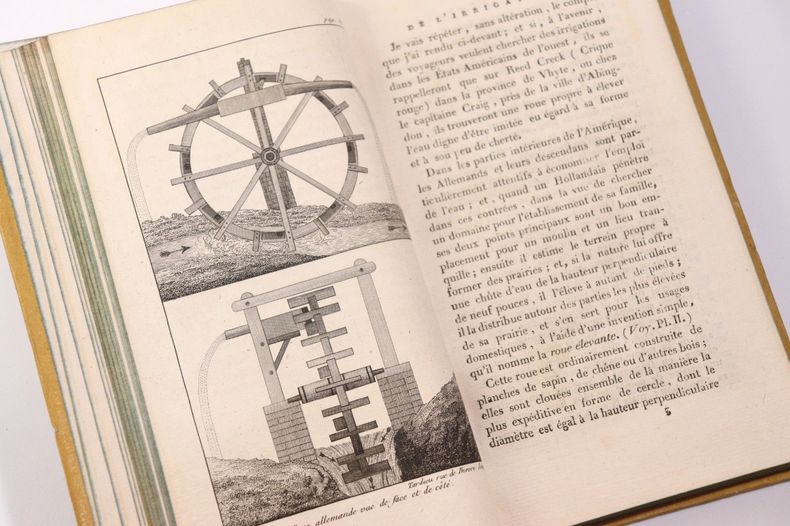
1806AMO-2638A Paris, chez Galland, 1806 [i.e. 1803] [de l'imprimerie de Langlois]. 1 volume in-8 (21 x 13 cm) de XII-(2)-309-(3) pages. 8 planches hors-texte. Édition originale française. Il s'agit bien ici de la première édition française publiée à Paris chez Meurant à la date de 1803 (an XI), remise en vente par le libraire Galland avec un nouveau titre à la date de 1806. Soit que le libraire Meurant aura fait faillite ou que le stock ne se vendait pas. Cet ouvrage a paru pour la première fois en anglais sous le titre : National Irrigation, or The Various Methods of Watering Meadows; Affording Means to Increase the Populations, Wealth, and Revenue of the Kingdom, by an Agricultural, Commercial, and General Economy in the Use of Water. (London, Carpenter, 1801). L'édition française a été remaniée par le traducteur français. Reliure de l'époque demi-veau caramel mou, dos lisse richement orné de filets et palettes dorés, pièce de titre de maroquin rouge, plats de papier jaune. Petite galerie de vers au mors (partie inférieure du premier plat), sinon exemplaire très bien conservé. Intérieur parfait. L'auteur passe en revue les différents moyens d'irrigation des terres dans les pays comme l'Amérique, l'Angleterre, l'Espagne, et la France. L'irrigation naturelle des prairies par les ruisseaux et les rivières précèdent les moyens artificiels (machines) alors proposés. William Tatham (1752-1819) est né en Angleterre (County of Cumberland). En 1769, il s'embarque à 16 ans pour la Virginie (Amériques) pour y étudier le commerce du tabac. Pendant la révolution il va suivre des études de droit en Caroline du Nord (admis en 1784). Il participe à la fondation de la ville de Lumberton en Caroline du Nord (1787). C'est durant cette période qu'il étudie et s'intéresse de très près à la construction des canaux d'irrigation, à la cartographie, etc. En 1796 il retourne en Angleterre et y restera 8 années. C'est durant cette période qu'il écrira plusieurs ouvrages relatifs à l'agriculture, au commerce, à l'architecture, etc. L'ouvrage qui lui valut la renommée est An Historical and Practical Essay on the Culture and Commerce of Tobacco (London, 1800). Il revient aux états-unis en Virginie. A 60 ans il part pour Washington où il est ingénieur topographique au ministère de la guerre jusqu'en 1815. La maladie le gagne rapidement. Grand collectionneur depuis des années, il doit se résigner à vendre sa collection de cartes géographiques et autres documents historiques. Tatham se suicide sur la place du Capitole de Richmond (il se place devant un canon qui tire en l'honneur de Washington). Il ne s'est jamais marié et n'a eu aucun enfant. Quel destin ! Bel exemplaire de cet ouvrage utile à l'agriculture et peu commun.
1891035628London / New York: Macmillan & Co. Ltd. 1889 1891. Second Edition With Appendix . Blue Cloth. Near Fine. 360 Pp Title Page Indicates Second Edition Dated 1889; This The Enlarged 1891 Issue With 60 Pp Appendix At End New Title Page Dated 1891. Second And Best Edition With The 1891 Appendix As Issued 1891. Fisher Described The Mechanism Of Plate Tectonics In 1881 Ascribing It To Convection Currents In The Earth's Molten Interior. This Work On Continental Drift Went Unnoticed Or Ridiculed But Was More Consistent With Modern Science Than The Criticisms Of His Work. An Unopened Copy Pages Still Attached Along Top Edge. Black Endpapers Immaculate Binding Firm No Names Or Marks. Very Scarce. <br/> <br/> Macmillan & Co. Ltd. (1889) hardcover
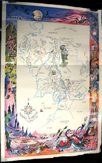
1965000015338New York: Ballantine Books 1965. Poster. Very Good. 37.5" x 25.25". Poster. A map of Middle Earth done in red blue green and black on a white background map bordered by a vivid color illustration of mountains ravens newts a dragon angry dogs an erupting volcano a spider web and a spider and a moonlit night. The recto of the poster glossy. Price of $1.49 on the bottom right corner of the poster. Scull & Hammond 639-646 710 801. The artist of the poster Barbara Remington was born in Minneapolis and later moved to New York to work as an illustrator. The production of this poster was rushed as Ballantine found itself in competition with Ace Books: both publishers were releasing paperback editions of the Lord of the Rings series. Ballantine wanted to beat Ace to the punch and gave Remington only days to complete this poster's design. An intricate visual representation of Tolkien's geography. One corner quite wrinkled and with an archival tape repair the right top edge of the poster wrinkled a few surface creases to the poster but it is complete with bright color. Ballantine Books unknown
177411283Paris, Panckouck, 1774 ; 2 tomes in-8 ; plein veau fauve marbré, dos à nerfs décoré et doré, titre doré, tranches rouges (reliure de l'époque) ; (4), XLVI, 428 pp. ; (4), 589, (3) pp. de Privilège, 1 grande planche dépliante ; le faux-titre porte "État général de la culture anglaise".
Mappa decorativa della Terra del Fuoco, Capo Horn e dello Stretto di Magellano.Comprende tre rose dei venti, in alto al centro un cartiglio con il titolo, uno stemma con la dedica a Constantino Hugenio, sette velieri e linee lossodromiche.La mappa reca la firma di Guglielmus Blaeu ma è stata pubblicata da suo figlio Johannes.In basso a sinistra scala di misurazione con raffigurati un gruppo di indigeni.Le linee costiere sono rappresentate come grandi catene montuose, mentre l'interno è completamente privo di dettagli. Arricchita da numerosi elementi decorativi. Willem Janszoon Blaeu, avviò nel 1599 la sua attività di costruttore di globi e strumenti astronomici ad Amsterdam. Nel 1630, dopo aver comprato alcune lastre dell’atlante del Mercator da Jodocus Hondius II, fu in grado di pubblicare un volume di 60 mappe con il titolo di Atlantis Appendix. Cinque anni dopo, pubblicò i primi due volumi del suo atlante Atlas Novus o Theatrum Orbis Terrarum, in sei libri. Dopo la sua morte, Joan (Johannes) continuò l’opera paterna, completando l’intera serie di sei volume dell’Atlas Novus intorno al 1655. Fu inoltre autore di un Atlas Maior sive Cosmographia Blaviana, in 12 volumi pubblicati nel 1662 -72. Incisione in rame, coloritura coeva, in buono stato di conservazione. A decorative map of Tierra de Fuego, Cape Horn with the Straits of Magellan. Includes three compass roses, title, key, and scale cartouches, and a dedication to Constantino Hugenio, seven sailing ships and rhumb lines. The map bears Willem Blaeu's signature but was published by his son Joan.Three strapwork cartouches with title, key and scale featuring a family group of natives.The coastlines are depicted as very mountainous, while the interior is completely without detail. Willem Janszoon Blaeu, started in 1599 his business as a builder of globes and astronomical instruments in Amsterdam. In 1630, after buying some plates of the Mercator atlas from Jodocus Hondius II, he was able to publish a volume of 60 maps under the title Atlantis Appendix. Five years later, he published the first two volumes of his atlas Atlas Novus or Theatrum Orbis Terrarum, in six books. After his death, Joan (Johannes) continued his father's work, completing the entire six-volume Atlas Novus series around 1655. He was also the author of an Atlas Maior sive Cosmographia Blaviana, in 12 volumes published in 1662 -72. Copperplate with fine original hand colour, in very good condition.
1664LBW-8886Paris, Antoine Bertier, 1664. In-4 de (10) ff., 498-(29) pp.; demi-basane fauve à petits coins de vélin vert, dos lisse orné, tranches marbrées (reliure début XIX° siècle).
Edizione italiana di un caposaldo della cartografia di Joseph Nicolas De L’Isle, la mappa del Nord Pacifico. Il De L’Isle passò gran parte del suo tempo in Russia, fondando l’ Accademia delle Scienze a San Pietroburgo; il suo lavoro cartografico più importante fu l’ "Atlas Russicus", dettagliata rappresentazione della regione. Nel 1747 tornò a Parigi, con una importante mappa manoscritta sul Nord Pacifico che includeva informazioni sul Nord Asia ed America e sullo stretto che le separava. Le informazioni erano frutto delle spedizioni russe nello Stretto di Bering effettuate tra il 1723 e il 1741. Il De L’Isle realizzò una carta molto dettagliata che fu pubblicata nel 1750, della quale vennero realizzate diverse copie in tutta Europa, inclusa questa del Santini, pubblicata dalla tipografia Remondini. La versione italiana è molto simile all’originale e si differenzia sostanzialmente per il cartiglio barocco con dei costumi popolari di abitanti della Kamchatka e della Louisiana. Carta geografica curata da don Paolo Santini e dal fratello Francesco per il loro prestigioso Atlas universel dressé sur les meilleures cartes modernes, sontuoso atlante composto da mappe che rielaborano la più aggiornata cartografia francese in una veste veneta. Le carte sono prese dai migliori geografi del suo tempo, D’Anville, Bellin, Bonne, Borgomo, Boscovich, Clarici, Delisle, Jaillot, Janvier, Robert de Vaugondy. In effetti nelle carte dei Santini, vengono mescolati termini francesi con italiani, ma sono offerte con una grazia compositiva ed incisoria loro caratteristiche: una toponomastica non fitta, scritta in grande e ben leggibile. L’atlante di Santini non ebbe una grande fortuna editoriale e uscì in poche copie: venne quindi ristampato dai Remondini, che avevano acquistato dal Santini nel 1781 le incisioni in rame. Alle carte di Paolo Santini, datate fra il 1774 e il 1780, i Remondini aggiunsero diverse altre carte, datate fra il 1782 e il 1784: fra queste, nel secondo volume, la grande carte ripiegata dell’Italia, la Repubblica di Genova, la Palestina, le grandi carte dell’Africa. Paolo Santini (1729, Venezia–1793, Belluno), sacerdote cattolico presso la Chiesa di Santa Maria Formosa a Venezia, docente di disegno alle scuole della città lagunare della Provincia Veneta della Compagnia di Gesù. Santini, cartografo, incisore ed editore, aggiornò e pubblicò le mappe dei geografi e cartografi francesi Gilles Robert de Vaugondy (1688–1766) e Didier Robert de Vaugondy (c. 1723–1786), ispirandosi anche alle opere dei cartografi italiani, innanzitutto a quelle di Giovanni Antonio Rizzi Zannoni (1736–1814). Utilizzando, come modello, le mappe raccolte e pubblicate nel 1752 nell’Atlas Universel di Gilles Robert e Didier Robert de Vaugondy, acquistate a Parigi da suo fratello, Francesco Santini, e le «migliori carte geografiche» dell’epoca, Paolo Santini incise nuove lastre e diede alle stampe a Venezia, nel 1776, l’Atlas Universel dressé sur les meilleures cartes modernes. L’anno successivo, 1777, cedette i diritti di pubblicazione all’editore Giuseppe Remondini (1754–1811) di Bassano del Grappa che ristampò l’«Atlas Universel» in due volumi che raccoglievano complessivamente 123 carte geografiche. Le matrici in rame in possesso dei Santini furono poi acquistate, nel 178, dalla stamperia Remondini. Incisione in rame, coloritura coeva dei contorni, in ottimo stato di conservazione. Bibliografia NMM III, 277; Nordenskiöld 276; Phillips, Atlases 647. Rodolfo Gallo, L'incisione nel '700 a Venezia e a Bassano, in “Ateneo Veneto”, A. CXXXII, v. 128, pp. 153-214; Tooley, The Mapping of America 104. An Italian edition of Joseph Nicolas De L’Isle's important map of the north Pacific. De L’Isle spent many years working as a cartographer in Russia, founding the Academy of Sciences in St. Petersburg and producing the first Russian Atlas. In 1747, De L’Isle returned to France with a manuscript map of the north Pacific, including information on northeastern Asia, northwestern America and the strait between the two. He produced an engraved map, which was presented to the French Academy of Sciences in 1750. This map was very advanced in some areas, being based on Russian expeditions of 1723, 1732 and 1741, along with Vitus Bering's first and second voyages and the explorations of a number of others such as Tchirkow and Frondat. Unfortunately, the cartography of northwestern America is based on the fictitious account of Admiral de Fonte, showing a huge inland sea, the "Mer de L'Ouest," and waterways leading off towards Baffin's Bay-the long sought for Northwest Passage. Delisle's rendering became the standard for the region until Cook's explorations later in the century. Delisle's map was copied by many publishers, including the Italian Santini, whose map was later issued by Remondini. The Italian versions have a handsome rococo title cartouche balanced by text and images of a native of Kamchatka and one of Louisiana. Map compiled by Don Paolo Santini and his brother Francesco, for their prestigious Atlas universel dressé sur les meilleures cartes modernes, a sumptuous Atlas composed of maps that rework the most up-to-date French cartography in a Venetian guise. The maps are taken from the best geographers of his time, D'Anville, Bellin, Bonne, Borgomo, Boscovich, Clarici, Delisle, Jaillot, Janvier, Robert de Vaugondy. Indeed, in Santini's maps, French terms are mixed with Italian, but they are offered with a compositional and engraving grace that is characteristic of them: an uncluttered toponymy, written large and clearly legible. Santini's Atlas did not have great publishing success and came out in few copies: it was then reprinted by the Remondini, who had purchased the copperplates from Santini in 1781. To Paolo Santini's maps, dated between 1774 and 1780, the Remondini added several other maps, dated between 1782 and 1784: among them, in the second volume, the large folded maps of Italy, the Republic of Genoa, Palestine, and the large maps of Africa. Paolo Santini (1729, Venice-1793, Belluno), Catholic priest at the Church of Santa Maria Formosa in Venice, professor of drawing at schools in the Lagooon city of the Venetian Province of the Society of Jesus. Santini, a cartographer, engraver and publisher, updated and published the maps of French geographers and cartographers Gilles Robert de Vaugondy (1688-1766) and Didier Robert de Vaugondy (c. 1723-1786), also drawing inspiration from the works of Italian cartographers, first and foremost those of Giovanni Antonio Rizzi Zannoni (1736-1814). Using, as a model, the maps collected and published in 1752 in the Atlas Universel by Gilles Robert and Didier Robert de Vaugondy, purchased in Paris by his brother, Francesco Santini, and the "best maps" of the time, Paolo Santini engraved new plates and gave to the presses in Venice, in 1776, the Atlas Universel dressé sur les meilleures cartes modernes. The following year, 1777, he sold the publishing rights to publisher Giuseppe Remondini (1754-1811) of Bassano del Grappa, who reprinted the "Atlas Universel" in two volumes that collected a total of 123 maps. The copper plates in the Santini's possession were later purchased, in 1781, by the Remondini printing house. Copperplate engraving, original outline coloring, in excellent condition. Bibliografia NMM III, 277; Nordenskiöld 276; Phillips, Atlases 647. Rodolfo Gallo, L'incisione nel '700 a Venezia e a Bassano, in “Ateneo Veneto”, A. CXXXII, v. 128, pp. 153-214.
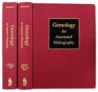
1993024443Metuchen New Jersey & London: The Scarecrow Press 1993. Appears unread. Near Fine condition. NOT a library discard. NO owner's name or bookplate. Pages are crisp clean and unmarked - apparently never read. 1993. First Edition. Gives detailed descriptions and expert evaluations of content for 7458 works. Uniformly bound in the original red cloth stamped in bright gold on the spine and over black panels on the front covers. Oversize Hardcover. 8.5" wide by 11.25" tall by 3.75" thick together. This extremely heavy 2 volume set will require extra postage for Priority and International shipments. But for media mail you pay only our standard charge for 1 volume and we ship the second volume at no extra cost. From the publisher: "Winner 1994 Geoscience Info Society Best Reference Work Award. This is the first comprehensive bibliography of gems and precious stones ever published containing over 7500 entries -- predominantly books but also periodical articles of significant material of historical value from 1500 up to 1985 with some books published after that date. All important works are described collated and assessed in terms of content accuracy and importance with remarks added on bindings and physical features that will enable librarians researchers booksellers and collectors to verify editions and states as well as completeness of copies. Illustrations; Subject index. The bibliography is based mostly on the John Sinkankas Library generally agreed to be the largest and most complete collection of its kind now in the Gemological Institute of America Santa Monica CA.". First Edition. Oversize Hardcover. Fine condition/No dust jackets as issued. Illus. by NOT a library discard. 2 volumes: 1206pp. Great Packaging Fast Shipping. The Scarecrow Press Hardcover
Three volumes restored and rebound in quarter-leather hardcover. Original dust jackets are included and in excellent condition. The boards have minor shelf-wear. Elaborate A4 book plate on the front paste down of each volume. Pristine pages throughout the main body, all clean and clear. GE Used
18993712616W. Holmes 1899. This is an ex-library book and may have the usual library/used-book markings inside.This book has hardback covers. In fair condition suitable as a study copy. No dust jacket. 4to 187 pages. Original blue cloth binding with silver title and crest to front cover. Exterior is heavily soiled and worn but there is minimal damage apart from some minor chipping to extremities. Binding is secure though there are some exposed gutters and pages are clean throughout though toned. 151 illustrations some in colour. Please note the Image in this listing is a stock photo and may not match the covers of the actual item1400grams ISBN: W. Holmes hardcover
9669P., Imprimerie Nationale, 1904. Affiche de 92 x 71 cm.
18475784726S. Lewis and Co 1847. Volumes 1-2 and Supplement . This is an ex-library book and may have the usual library/used-book markings inside.This book has hardback covers. In good all round condition. Large black cloth 8vo with decorative blind borders on boards and gilt lettering and gilt borders on backstrip. Bumped corners and light general wear. Interior is secure clean and clear. Hinges in vol 1and 2 split. Supplementary Atlas volume is complete containing several large fold out maps. Interiors are secure clean and clear save for some foxing. Trimmed. Please note the Image in this listing is a stock photo and may not match the covers of the actual item4350grams ISBN: S. Lewis and Co hardcover
176147666Imprimerie Royale Cuir Paris 1761
167514546Paris, Guillaume Desprez, 1675 ; in-16 ; plein veau havane granité, dos à nerfs décoré et doré, titre doré, roulette sur les coupes (reliure de l'époque) ; (36) (titre, Epistre, Préface et Table), 457 pp., (1) p. de Privilège, 59 figures et schémas dont 13 hors-texte.
In 12° (16x8,5 cm); (6),180, (4) pp., e 5 c. di tav. fuori testo più volte ripiegate (due tavole sono in questo esemplare unite insieme in un'unica tavola).Legatura coeva in piena pelle. Dorso a 5 nervi con titolo e ricchi fregi ai tasselli (cerniera del piatto anteriore lenta e strofinature ai piatti).Tagli spruzzati in rosso. Prima edizione assai rara di questo celebre viaggio immaginario nel quale l'autore parte dall'olanda per dirigersi in Groenlandia e da qui entrare nelle profondità della terra per poi riapparire dal parte opposta della terra. L'opera si inserisce nel filone dei viaggi immaginari e delle descrizioni utopistiche. La prima edizione di quest'opera uscì nel 1721 anche se con sole 3 tavole e con testo leggermente differente rispetto alle edizioni succesive. Questa del 1723 è la seconda, stampata da Amaulry anche se con lo stesso anno se ne trovano anche con altre intestazioni di stampatori. Tutte le prime tre edizioni 1721-1723-1724 sono assai rare. Una leggera e assolutamente non fastidiosa gora nel margine basso bianco da pagina 135 a 138 e per il resto, all'interno, in buone-ottime condizioni di conservaizone. Gove, Philip Babcock: The Imaginary Voyage in Prose Fiction: from 1700 to 1800 ; Versins - 944 <BR>
A Spese della Società Editrice,1857. In 8°pp.338n.con 12 Tavv. Incise di Vedute+ III Tavv. Incise su Unica Tav.ripiegata,+ 3 grandi Tavv. più volte ripiegate alla fine.legatura mz.tela e punte, piatti in carta francese. Forellini di ex tarli che interessano solo la tela della legat.
1822176291822 Paris, Béthune & Plon for Leblanc, (1822). atlas vol. in folio. Sans page de titre ni reliure,broche,mouillures en marge,carte abimée,25 lithographies en noir,dans l’etat
Affascinante e decorativa carta geografica della Terra Santa derivata da quella di Adricom, rispetto alla quale è abbellita da una serie di diciotto riquadri in cui sono raffigurati monumenti ed oggetti legati alla religione ebraica. Contribuiscono ad arricchire la decoratività il compasso della scala grafica, i galeoni e la rosa dei venti che riporta l'orientamento della carta. Inoltre in basso a centro, entro un cartiglio a volute, si trova la raffigurazione planimetrica della città di Gerusalemme basata sul celebre modello di Villalpando. Prima edizione stampata ad Anvera nel 1632. Esemplare in perfetto stato di conservazione caratterizzato da vivace ed omogenea inchiostratura.
La mappa raffigura la costa nord-occidentale del Nord America, e quella nord-orientale dell'Asia utilizzando le scoperte dei Russi riportate da J. N. De L'isle. La cartografia non è prettamente scientifica, di qui una serie di errori come ad esempio, solo per citarne alcuni, la miitica colonia cinese Fou Sang, quale traccia di una colonizzazione cinese nella regione, e lo Stretto di Anian rappresentato al posto dell'attuale Vancouver. Questi errori saranno corretti negli anni successivi soprattutto grazie ai rapporti dei grandi navigatori, tra i quali l'inglese James Cook. Il cartiglio pittorico comprende una mitica isola deserta sulla quale vivono numerosi animali i più adatti a climi tropicali - un coccodrillo, un elefante, un rinoceronte e uno struzzo. La nave raffigurato nella vignetta è quasi certamente è la nave del capitano Cook, l'Endeavour. Carta geografica tratta dall’Atlante novissimo, illustrato ed accresciuto sulle osservazioni e scoperte fatte dai più celebri e più recenti geografi. Stampato in quattro volumi da Antonio Zatta tra il 1779 ed il 1785. Atlante fra i più belli e completi mai pubblicati in Italia nel XVIII secolo, l'opera più famosa dello Zatta.L’Atlante Novissimo, come si specifica anche nel titolo, è “accresciuto sulle osservazioni scoperte fatte dai più celebri e più recenti geografi”. Tra le novità più significative vi è la comparsa delle nuove isole scoperte nell'Oceano Pacifico da James Cook e la prima carta italiana della Nuova Zelanda. Le illustrazioni furono ideate e disegnate dai suoi collaboratori Giovanni Marco Pitteri, Anton Friedrich Busching, Pietro Antonio Novelli ed incise da Giuliano Zuliani. Il primo tomo dell’atlante è introdotto da un breve saggio di geografia generale dove l’autore definisce in modo sintetico e preciso gli elementi che compongono i reticoli eclittico ed equatoriale usati nelle tavole. Interessante la sezione dove si sofferma a descrivere il fenomeno della precessione degli equinozi e quello della variazione ciclica dell'obliquità dell'eclittica. Acquaforte, stampata su carta vergata coeva, coloritura coeva dei contorni, in buone condizioni. Striking example of Zatta's map of the northern Pacific Coastal regions and one of the best illustrations of a late rendition of the Northwest Passage, here illustrating two wide passages from the Pacific to Hudson's Bay, based upon the mythical voyages of Admirals Cluny and de Font. The map depicts the Northwest coast of North America and Northeast coast of Asia and utilizes the Russian discoveries reported by J.N. De L'Isle. The map is noteworthy for the odd archipelago of islands off NE Asia, the rivers extending from the Pacific Coast to the interior of North America and the odd projection of the western coast of North America. This conical projection shows the western coast of North America from the Baja Peninsula, along the coast of California to Alaska and thence to the Bering Strait and the Kamchatka Peninsula. The map is filled with hypothetical cartography based on misunderstood or mythical reports about the northern Pacific shores. Alaska is represented by a group of islands clustered off the coast of Russia, and the northwest coast of North America is filled with the fictitious system of rivers and lakes of the mythical Northwest Passage and discoveries of Admiral de Fonte. The map shows locations of ethnic groups and communities, and mentions the legendary Quivara (an alternative name for southwestern North America). Canada is broadly conceived, with waterways across the north related to the search for a Northwest Passage. The erroneous belief that that Chinese mariners colonized America in the late 5th Century led to the mythical "Fou-Sang" (colony of the Chinese) and the so-called Straits of Anian noted on the map in what is now Vancouver, British Columbia. Wagner declares the map to be "A Vaugondy mixture of old and new names as far south as the end of the peninsula." All of this unscientific mapmaking would change quickly in the ensuing decades, as cartography benefited from a large number of expeditions in Arctic latitudes, beginning with the great English circumnavigator James Cook. As with many maps by the famous mapmaker, the large decorative title vignette dominates. The pictorial cartouche includes a mythical desert island on which live several incongruent animals, all more suited to tropical climates - a crocodile, an elephant, a rhinoceros and an ostrich. The ship depicted in the vignette almost certainly is Captain Cook's ship, the Endeavour. Map from the Atlante novissimo, illustrato ed accresciuto sulle osservazioni e scoperte fatte dai più celebri e più recenti geografi. Printed in four volumes by Antonio Zatta between 1779 and 1785. Atlas among the most beautiful and complete ever published in Italy in the eighteenth century, the most famous work of Zatta. The Atlante Novissimo, as also specified in the title, is “increased on the observations made by the most famous and most recent geographers”. Among the most significant innovations there is the appearance of the new islands discovered in the Pacific Ocean by James Cook and the first Italian map of New Zealand. The illustrations were designed and drawn by his collaborators Giovanni Marco Pitteri, Anton Friedrich Busching, Pietro Antonio Novelli and engraved by Giuliano Zuliani. The first volume of the atlas is introduced by a brief essay of general geography where the author defines in a concise and precise way the elements that make up the ecliptic and equatorial grids used in the tables. Interesting is the section where he pauses to describe the phenomenon of precession of the equinoxes and the cyclical variation of the obliquity of the ecliptic. Etching, printed on contemporary laid paper, contemporary outline coloring, in good condition.
0817SB0Y5X7Hardcover. Very Good. Good plus on the outside very good inside. With only occasional foxing and toning. Fall brown leather with bright red leather label and gold gilt lettering. The first addition of the first book created please see our photos. No reader remainder or library Marks… Volumes one and two…complete… Well bound hardcover
41556Enrichies par ce savant d'une vue générale des progrès des Sciences Naturelles. P. Emery, 1828-29. 26 volumes in-8. Demi chagrin noir, dos à nerfs ornés de filets dorés. Reliure fin XIXème.
177628417Nantes 1776-1807 1 - un ACTE original de 4 pages manuscrites à l'encre brune sur velin parcheminé, format : 20 centimètres de large x 26,8 centimètres de haut, timbre fiscal en noir en haut de la 1ère page : "BRETAGNE - 20 sols ", signature du notaire : JALABER, ACTE RÉGLANT UN DIFFÉREND DE TERRES EN AFFÉAGEMENT DÉPENDANTES DE LA TERRE DE L'ÉPINAY EN CARQUEFOU ENTRE MESSIRE LOUIS MERGEY, PRETRE DU PRIEURE DE ST MARTIN EN SAINTE-CROIX (NANTES) ET LA MADELEINE-EN-BOIS EN CARQUEFOU ET LA FAMILLE CROPP, NANTES LE 30 AOUT 1780............... - 2- ACTE ORIGINAL DE PARTAGE de 12 pages manuscrites à l'encre brune sur papier vergé bleuté, ligné et filigrané aux armes royales, format : 38 x 24,5 cm, sigatures manuscrites de : CROPP L'AINE, J. WILMS, et Jean Baptiste CROPP, PARTAGE DE LA TERRE DE L'ÉPINAY EN 3 LOTTIES A LA FAMILLE CROPP, NANTES, LE 10 OCTOBRE 1788................ - 3- ORIGINE DE PROPRIÉTÉ ET ASSIETTE DU PRÉCIPUT de 12 pages manuscrites à l'encre brune sur papier vergé crème (importante mouillure ancienne mais tout est trés lisible), ligné et filigrané :"TIMBRE ROYAL" , format : 29,6 x 21 cm, ORIGINE DE PROPRIÉTÉ ET ASSIETTE DU PRÉCIPUT, PARTAGE DU DOMAINE DE L'ÉPINAY , A NANTES, LE 9 DÉCEMBRE 1807,signature de Pierre Poupourreau Huissier Audiencier........... - 4 - COPIE D'EPOQUE D'ACTE DE PARTAGE DE FAMILLE de 4 pages manuscrites à l'encre brune sur papier vergé crème, ligné et filigrané : "BLANCHARD EN MARCHE - Cornet sur écu couronné, en pendentif : 4 à double chevron "(importante mouillure ancienne mais tout est trés lisible), format : 36,5 x 23,5 cm, signé Taverne Linsens, COPIE D'EPOQUE D'ACTE DE PARTAGE DE FAMILLE, DE DAME ANNE TAVERNE, FILLE DE LOUIS TAVERNE DE BEAUVAL NÉGOCIANT NÉGRIER AUX CAYES, ILE DE SAINT-DOMINGUE [PROPRIÉTAIRE INITIAL], VEUVE DE NOBLE HOMME MARTIN LINSENS NÉGOCIANT, PROPRIÉTAIRE DE LA SEIGNEURIE DE L'ÉPINAY & PROCÉ EN CARQUEFOU A LA FAMILLE CROPP DE LOTS DE TERRES DE LA SEIGNEURIE DE L'EPINAY ET PROCÉ, FAIT A NANTES, LE 11 JUIN 1776 ........... - 5- ACTE D'AFFÉAGEMENT de 4 pages manuscrites à l'encre brune sur papier vergé crème, ligné (importante mouillure ancienne mais tout est trés lisible), format : 31,5 x 20,6 cm, signature manuscrites de RIVET DE LA FOURNERIE, CROPP l'Ainé et LINSENS, ACTE D'AFFÉAGEMENT DE 3 JOURNAUX DE LANDES BORDANT LES TERRES DU HOUSSEAU PAR L'ABBÉ MERGY, TITULAIRE DU PRIEURÉ DE LA MADELAINE A MR RIVET DE LA FOURNERIE PUIS CÉDÉ AUX FRERES CROPP , NANTES, LE 29 FEVRIER 1788,