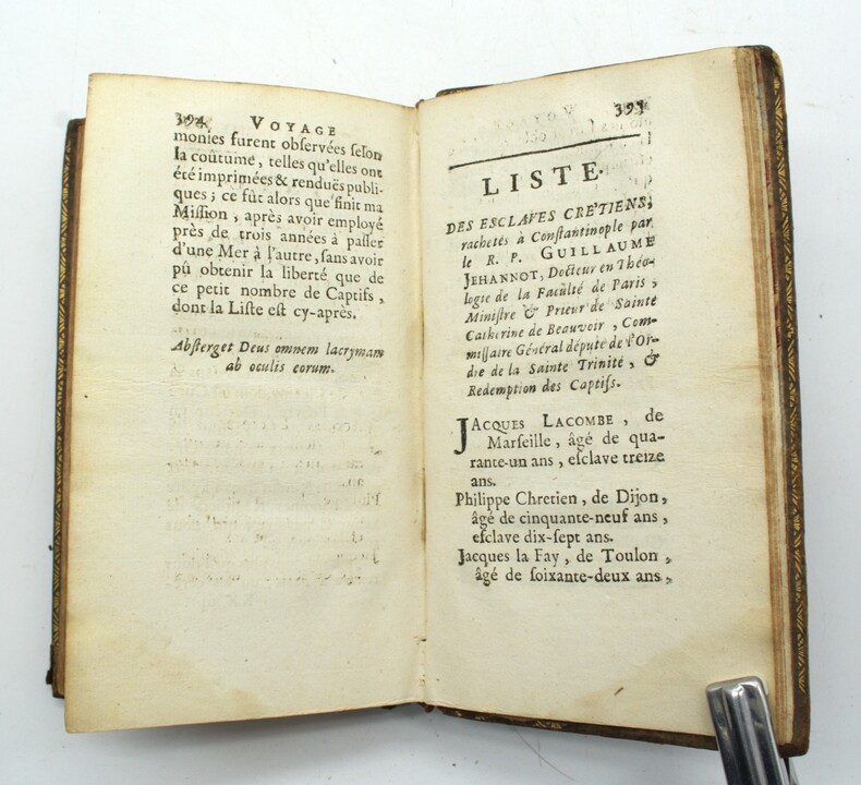
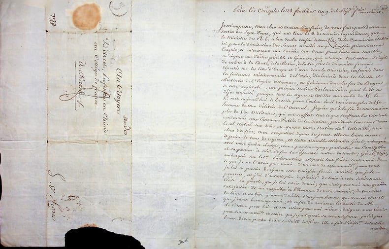
2 100 résultats
Fine Fine English Original bdg. Dust wrapper. Folio. (34 x 25 cm). In Turkish. 1168 p., color and b/w ills. A comprehensive study on the Princes' Islands throughout the history.
1854yd1551J. Noël et Fourmage, éditeurs Carte 1854 Carte ancienne (env. 87 x 63 cm dépliée), de l'Empire Ottoman, théâtre de la guerre en Europe et en Asie, dressée par Hérisson, comprenant un plan de Constantinople, de Chouma et ses environs, de Varna et de Silistrie, ainsi que de magnifiques ornements aquarellés (drapeaux), 2e édition, 1854 ; un petit défaut dans la marge gauche, par ailleurs très bel exemplaire. Livraison a domicile (La Poste) ou en Mondial Relay sur simple demande.
1732PHO-1798Paris, Veuve Delormel et René Josse, 1732. In-12, plein veau, dos orné, pièce de titre rouge, tranches rouges (Reliure de l'époque). Ex-libris et ex-dono manuscrits anciens au titre, frottements et épidermures, coiffe sup. accidentée, 1 coin usé, manque le plan de Troie.
1369414Paris: H. Nicolle, 1815 3 volumes in-8 de 438, 467 et 476 pages. Reliure basane racinée d'époque, dos lisse orné de fleurons, plats encadrés de 2 filets dorés et d'une dentelle de petits cercles, plats frottés et coiffes un peu usées sinon bel exemplaire dans une jolie reliure. Sans l'atlas. L'auteur était officier attaché à l'Ambassade de France près la Porte Ottomane.
183362Berlin, G. Reimer, 1824-1825 2 tomes en un vol. in-4 carré, [4]-581 pp. en pagination continue, texte [grec seulement] sur deux colonnes, index, demi-veau prune, dos lisse orné de guirlandes en long et filets dorés, ainsi que de fleurons à froid, tranches marbrées (reliure de l'époque). Dos passé, rousseurs abondantes.
Very Good Turkish, Ottoman (1500-1928) Original color map. 65,5x63 cm. In Ottoman script. This rare and decorative Gallipoli map including Hellespont, Gallipoli Peninsula, Suvla Bay, Seddülbahir, and Tenedos, the places of Gallipoli Aar in 1915 (Dardanelles Campaign) during World War 1, separated two map views. Seddulbahir and Suvla Bay at north and Straight, Peninsula, and its shores with Tenedos (now Bozcaada) at the southwest of the map. It's a very detailed and rare map printed with the series of "History of the Dardanelles Campaign" after the seven years of war. The Gallipoli campaign, also known as the Dardanelles campaign, the Battle of Gallipoli or the Battle of Çanakkale (Turkish: Çanakkale Savasi, or, Muharebâti), was a military campaign in the First World War that took place on the Gallipoli peninsula (Gelibolu in modern Turkey), from 17 February 1915 to 9 January 1916. The Entente powers, Britain (with Anzacs), France, and Russia, sought to weaken the Ottoman Empire, one of the Central Powers, by taking control of the Turkish straits.
New Turkish Original bdg. HC. In publisher special box. Atlas folio. In Turkish. 336 p., fully color ills. Tarihte Türkiye haritalari: 2000 yillik harita koleksiyonu. This work begins from the first ages, continues with maps from Islamic geographers, maps with religious motifs, maps from the age of explorations and from the Ottoman Empire, goes until the Arabic letter maps from the early years of the Turkish Republic and ends with the map of Hatay joining the Turkish Republic in 1939. It is an indispensible work that traces the evolution of cartography in these lands. The collection, enriched with maps compiled from the major museums and libraries of England, France, the Netherlands, Russia and the USA, is the largest exhibition of maps of the Turkish lands. THis book is a product of nearly 20 years of work with 265 select maps in large 50 x 70 cm pages. A very heavy volume.
New English Original decorated leather bound. 4 compartments at spine. 19 volumes set: (217, [23] p.; 335 p.; 504 p.; 495 p.; 279 p.; 415 p.; 448 p.; 352 p.; 672 p.; 512 p.; 527 p.; 393, [4] p.; 397-794 p.; 272 p.; 240 p.; 224 p.; 224 p.; 396 p.; 376 p.). In Turkish. Color and b/w ills. "Eyüpsultan külliyati. Tarihi, kültürü ve sanatiyla: Vol.1: Eyüpsultan Sempozyumu I. Tebligler. Vol.2: Eyüpsultan Sempozyumu II. Tebligler. Vol.3: Eyüpsultan Sempozyumu III. Tebligler. Vol.4: Eyüpsultan Sempozyumu IV. Tebligler. Vol.5: Eyüpsultan Sempozyumu V. Tebligler. Vol.6: Eyüpsultan Sempozyumu VI. Tebligler. Vol.7: Eyüpsultan Sempozyumu VII. Tebligler. Vol.8: Eyüpsultan Sempozyumu VIII. Tebligler. Vol.9: Eyüpsultan Sempozyumu IX. Tebligler. Vol.10: Eyüpsultan Sempozyumu X. Tebligler. Vol.11: Eyüpsultan Sempozyumu IX seçki. Vol.12: Mehmet Nermi Haskan: Eyüp Sultan tarihi 1. Vol.13: Mehmet Nermi Haskan: Eyüp Sultan tarihi 2. Vol.14: Mehmet Nermi Haskan: Eyüplü meshurlar 1. Vol.15: Mehmet Nermi Haskan: Eyüplü meshurlar 2. Vol.16: Mehmet Nermi Haskan: Eyüplü hattatlar. Vol.17: Mehmet Nermi Haskan: Eyüplü musikisinaslar. Vol.18: Alasonyali Haci Cemal Ögüt: Eyyüb Sultan. Hz. Halid Ebu Eyyüb el-Ensari. Vol.19: Eyüp'ün altin yillari: 1994-2009.". Very heavy volumes as set. Will be sent with original trade box.
Very Good Turkish, Ottoman (1500-1928) Original cromolithograph mounted on cloth. Folded. Some foxing and slimming on creases. Oblong double elephant folio. (97 x 107 cm). In Ottoman script. Shows the Bosphorus, Istanbul city with detailed place names. Black Sea at North, Marmara Sea at South and the Princes' Islands seen at southwest area. Mapmaker not described usual like in Turkish military maps. An extremely rare the Bosphorus map with its unusual size. Not in TBBMM library (The Grand Assembly of Turkish Republic Liibrary). Not in Military Libraries in Turkey.
Very Good Turkish, Ottoman (1500-1928) Original color map. Folded. Oblong atlas folio. (50 x 60 cm). In Ottoman script. Shows Rhodes and Tilos Islands. Scale: 1/200.000. Hegira: 1332 = Gregorian: 1916. Not description on map-maker. This is one of the series of the Bonn projection maps which are the first map series in modern techniques in Turkey and the Ottoman Empire. This is one of the series of the Bonn projection maps which are the first map series in modern techniques in Turkey and the Ottoman Empire. In order to produce these maps covering Turkish territory, Reconnaissance Branch was incorporated into The Mapping Commission. The maps were produced in the datum based on the latitude and longitude of Ayasofya Mosque in an equal area Bonn Projection. The field works for the 123 sheets covering the country were conducted by 76 staff. The production was completed in 18 years starting from east-west. Fieldworks continued without stopping except in the years 1914 and 1920. This map series called also reconnaissance maps contributed a lot to producing 1:25.000 scale maps. A very detailed and attractive map of Rhodes Island showing its harbors and Ottoman place names.
New English Original bdg. Atlas folio. (47 x 33 cm). Turkish text with figure captions in Turkish, German and English. 23, 128 p., 205 p. of plts., b/w ills. A very detailed and comprehensive survey of Constantinople's architecture, concentrating mainly on the religious. 150 copies were printed.
Original letter penned and signed by Layard after the Bulgarian uprising in the Balkans. The letter measures 7 x 9 inches dated February 23, 1878 while he was HBM Ambassador in Constantinople. The letter provides a reference for a James Long, MA who was a humanitarian. Long was about to go to Bazandjik on the Danube in Bulgaria which had recently been occupied by the Russians during the Russo-Turkish War. Together with the letter is an original portrait photograph of Layard measuring 8 x 10 inches as well as a contemporary bigraphical sketch from the 1880's. Letters from Layard while abroad are rare. Manuscript
020002Pierre Ruffin (1742-1824), diplomate, consul de France à Constantinople, interprète des langues orientales. L.A.S., Péra [Constantinople], 28 fructidor an 9 [15 septembre 1801], 1p 1/2 in-4. Longue et importante lettre au chimiste Jean d'Arcet (1724-1801) dont il ne savait pas la mort (12 février 1801). Il n'y a aucun doute pour le destinataire car c'est adressé au professeur au collège de France. Très belle lettre au moment où les Français, prisonniers depuis 2 ou 3 ans, sont enfin libérés. « Je m'empresse, mon cher et ancien confrère, de vous faire part de ma sortie des Sept-Tours, qui eut lieu le 8 de ce mois. La présidence, que le ministre des R.E. a bien voulu confier à mon zèle, de la commission établie ici pour la distribution des secours accordés aux français prisonniers en Turquie ; en m'ouvrant une carrière bien douce pour une âme sensible, m'impose une tâche pénible et épineuse, qui m'occupe tout entier. Il s'agit de rendre à la liberté, à la Patrie, à la vie près de deux mille français déportés sur les côtes d'Europe et d'Asie dans la mer noire, renfermés dans les forteresses méditerranées de l'Asie, disséminés dans les échelles et Provinces de l'Empire Ottoman, ou gémissant dans les fers du Beyne de cette capitale. Un premier navire parlementaire parti le 24 a déjà emporté presque tous les agents et artistes au nombre de 85. Le 2e met aujourd'hui à la voile pour Toulon, où il ramènera plus de 150 hommes de mes délivrés de l'Arsenal. J'espère qu'à la fin de cette semaine près de 500 militaires, qui ont souffert tout ce que souffrent les criminels condamnés aux travaux publics de la Marine, prendront leur essor vers le sol natal sur trois ou quatre autres navires etc. Telle a été, mon cher confrère, mon occupation depuis 20 jours. Elle me laisse encore à peine le temps de respirer et notre aimable Alexandre Gérard, embarqué avec mon gendre [Barthélémy de] Lesseps, connu par son voyage particulier au Kamtchatka et sa portion à celui de feu La Peyrouse autour du monde ; Gérard, dis-je, embarqué sur le 1er parlementaire est parti tout fâché contre moi de ce que je ne l'avais pas muni d'un mot de recommandation pour vous. je lui ai promis de réparer cette omission forcée aussitôt que je le pourrais et j'ai d'autant plus de plaisir de tenir à votre intéressant élève la parole que je lui avais donné ; que c'est pour moi une grande satisfaction de me rappeler à l'honneur de votre souvenir ; de vous dire du bien et un bien grandement mérité d'un jeune homme qui vous est cher et que j'aime beaucoup aussi ; et enfin de réclamer les bontés de M. Le Breton pour lui et son estime pour moi-même. Daignez vous réunir pour son avancement et croire que je partagerai sa reconnaissance. Je n'ai pas besoin de vous parler de sa conduite à Péra. Elle a fait l'édification de tout le monde. Permettez-moi de placer ici mes très humbles remerciements à M. Le Breton, du bon accueil qu'il a fait à mon fils et de tous les services qu'il a bien voulu lui rendre. Vous apprendrez volontiers, mon cher confrère, la délivrance que j'ai été assez heureux pour obtenir, du citoyen Beauchamp, qui, après avoir couru les plus grands dangers, avait été détenu au château de Fanaraki à l'embouchure de la mer noire. Malheureusement, à ma sortie des Sept Tours, le citoyen Beauchamp se trouvait attaqué d'une maladie très grave. Je l'ai fait transporter à Péra accompagné de deux chirurgiens et d'un médecin français. Il n'est pas encore hors d'affaire, mais on espère beaucoup qu'il soutiendra les cruels assauts de la vomique, qu'il expertore depuis 15 jours ; et j'aime à me flatter que j'aurai le bonheur de me conserver à moi-même cet ami de 30 ans, et aux sciences un homme précieux à tous égards. Ne m'oubliez point, je vous en supplie, auprès de la famille et des amis du jeune Gérard, et soyez persuadé de la sincérité, de l'estime et de l'attachement avec lesquels je serai toute ma vie votre confrère et ami P. Ruffin ». La lettre mentionne donc Bart
1784PHO-1112Amsterdam, s.n., 1784, 3 tomes, in-8, lvj, 274 ; 301 ; 252-208pp. ,relié plein cuir moucheté , dos lisse orné avec pièces de titre et tomaison , frise dorée sur les plats , tranches marbrées, coins usés , frottements ,petites rousseurs , Joli cachet de l'École d'artillerie de la garde impériale »
1784PHO-1205Amsterdam, s.n., 1784, 4 parties en 2 volumes , in-8, xl, 203 ; 220 ; 180-152pp. ,relié plein cuir marbré , dos à nerfs orné avec pièces de titre et tomaison , tranches marbrées, coins et coiffes usés , frottements ,ex-libris manuscrit barré aux titres (1 et 3)
1784PHO-1774Amsterdam, s.n., 1784, 3 tomes en 2 volumes, in-8, lvj, 274 ; 301; 252-208pp., relié plein veau , dos lisse orné avec pièces de titre et tomaison (reliure moderne).
Very Good Armenian Original fine red cloth bdg. with decorative gilt on board. Spine is repaired masterfully. Large roy. 8vo. (25 x 18 cm). In Armenian. [24], 429 p., 1 folded Armenian map of Turkey (map size: 24x33 cm), 29 unnumbered full-page b/w plates (one is folded). Armenian Golgotha is a memoir written by Grigoris Balakian about his eyewitness account of the Armenian Events. The memoir was released in two volumes. Volume 1, about his life prior to and during the Armenian Deportation, was released in 1922. Volume 2, about his life as a fugitive after the Deportation, was released in 1959. Originally published in Armenian, the memoir was later published in various languages including an English translation by Peter Balakian, Balakian's great-nephew, with Aris Sevag. Grigoris Balakian [or, Palakean, Palakian, Balakean], was a bishop of the Armenian Apostolic Church, in addition to being a survivor and memoirist of the Armenian Events in the Ottoman Empire. Grigoris Balakian was born in Tokat in the Ottoman Empire and graduated from the Sanasarian College in Erzurum. He had been studying architecture in Germany for two years and got a degree in civil engineering. He became a celibate priest ordained under the monastic name Grigoris Balakian. On 24 April 1915, he was among the group of 250 leading Armenian figures of Constantinople who were arrested and deported. One group was deported to Ayas. Balakian was deported to Çankiri, north-east of Ankara with the rest of the 190 other deportees from the capital. Only 16 of them would survive. He marched with 48 deportees from Çankiri in the direction of Deir Al-Zor in the Syrian desert. On the way, Balakian won the confidence of captain of constabulary Shukri Bey and learned about the Ottoman government's plan to exterminate the whole Armenian population. Balakian was able to flee toward Islahie. He joined a group of workers on the Bagdad-railway where Turkish deserters did forced labor alongside Armenian refugees. While Armenian workers between Marash and Bartche were being slain, Balakian fled to another construction site on the Bagdad railway. He was helped by German engineers and finally succeeded - disguised as Herr Bernstein - in escaping from Constantinople to Paris. At the 1921 trial in Berlin against Soghomon Tehlirian, the murderer of Talât Pasha, Balakian appeared as a witness for the defendant together with Johannes Lepsius. Soghomon Tehlirian was ultimately acquitted. Balakian became prelate of Manchester, London, and finally bishop of Marseille. Two churches were built under his guidance in Marseille and Nice (St. Mary, 1928) as well as a number of chapels and schools. He died in Marseille. Balakian is the granduncle of Anna Balakian, an expert on symbolism and surrealism who chaired New York University's Department of Comparative Literature, and the great-granduncle of Peter Balakian, an Armenian-American writer and winner of the 2016 Pulitzer Prize for Poetry. Balakian's memoirs in Armenian Golgotha are an important eyewitness account of the Armenian Events. He describes his experiences during the deportation. Balakian was one of the few surviving leaders of the Armenian community who gave an account of the deportation. Komitas (Gomitas) Vartapet belonged to the same group of detainees as Balakian. His information about the traumatization of the famous composer and founder of modern Armenian classical music is of eminent importance. OCLC: 1137218025. First Armenian Edition. Rare.
1651047499London: ex officina Rogeri Danielis 1651. viii 393 10p. title in Greek and Latin with parallel Greek and Latin text major index at the end. Bound in period full dark brown leather with red leather spine label and gilt lettering upper one-inch of spine lightly chipped. Tight hinges original endpapers. Small 18th-century signature of "Wm. Henderson" on upper margin of t.p. plus signature and small name label of Kiffin Ayres Rockwell who acquired the copy in November of 1954 on the front flyleaf. Edited from a Bodleaian ms. by Richard Montague 1577-1641 and published after his death. Totalling 248 letters on the controversies of the Photian 9th-century reign as patriarch this is the earliest edition of the correspondence from this Bodleian manuscript. Wing P2136; ESTC R12714. ex officina Rogeri Danielis unknown books
Very Good Greek, Modern (post 1453) Original wrappers. Large 8vo. (21 x 16 cm). In Greek (Modern). 21 p. First and only edition of this exceedingly rare and one of the earliest church regulations of the Greek Orthodox community of Attalia [Antalya]. Attalia was not a large urban center or major trading hub, but neither was the Greek Community marginal, and it was well integrated into the regional economy. It was different from other areas in Asia Minor due to a combination of factors ranging between demography, geography, local Orthodox leadership, and the city's social milieu. In contrast to the West-coast cities and many villages in Asia Minor with Orthodox majorities, Attalia's population was only about one-third Orthodox. The main area of difference in Antalya was the Community leadership, which was key to the maintenance of cordial relationships between Christians and Muslims, and the secular and ecclesiastical elements of Orthodox leadership in Antalya tended to cooperate for collective benefit. Throughout this period, a local elite managed to control education and other Community institutions, perpetuating an identity that was compatible with the local Ottoman context. In this last period, the Greek Community printed several books and tractates including a brief history of Antalya and this "regulation book" in the Meli Printing House, which was the only printing house of the Greek Community in Antalya. Only one institutional copy is located in OCLC 1030075331 (Suna Kiraç Library of the Koç University).
Very Good Turkish, Ottoman (1500-1928) Original pictorial wrappers. Chromo-lithographed photo-montage collage cover with seven b/w photos of African buildings and natives, and a red map of Africa. Complete in wrappers and folded huge Africa map (size: 57 x 82 cm). Cover size: 28.5 x 20.5 cm. In Turkish. Scale: 1/20,000,000. A very rare chromo-lithographed Africa map, prepared for the geography lessons about foreign countries in Turkey in 1930. The map shows the territories of the African continent, which was still politically under European colonialism as of the 1930s. It includes Rio de Oro (Spanish territory), Fas [i.e. Morocco], Algeria, Sahara, Cameroon (French territories), Trabulus [i.e. Libya] as Italian territory; and Liberia, Egypt, East Sudan, Eritre [i.e. Eritrea], Habesistan [i.e. Ethiopia], Somali, Kenya, Belgian Kongo, Angola, Mozambique and South African land including Rhodesia (equivalent in the territory to modern Zimbabwe), Transvaal, The Orange Free State [Oranje-Vrystaat], Natal and Kap [Cape] with Madagascar. An extra panel for the same scale map showing the Suez Canal, Nile Delta, and North Egypt in the lower-left corner. Duran studied in Istanbul and Paris. He worked as a geography teacher in various high schools and afterward he undertook the positions of lecturer and administrator in Ankara Gazi Education Institute for a time. He was known for his writings on various topics and particularly for his works on geography. Born in the imperial period, Duran conducted the first cartographic studies of the Republic of Turkey after the transition to the Republican administration. Sealed. Slight foxing. Otherwise a fine copy. Not in OCLC.
Very Good French Original decorated map. Hand-coloured. Oblong elephant folio. (54 x 76 cm). In French. Shows Greece, Archipelago, Isle de Candie, Asia Minor (Western side), and East Mediterranean. Delisle od de l'Isle was a French cartographer known for his popular and accurate maps of Europe and the newly explored Americas. At 27, Delisle was admitted into the French Académie Royale des Sciences, an institution financed by the French state. After that date, he signed his maps with the title of "Géographe de l'Académie". Five years later, he moved to the Quai de l'Horloge in Paris, a true publishing hub where his business prospered. Delisle's progress culminated in 1718 when he received the title of Premier Géographe du Roi. He was appointed to teach geography to the Dauphin, King Louis XIV's son, a task for which he received a salary. Again, his father's reputation as a man of science probably helped the younger Delisle. Historian Mary Sponberg Pedley says, 'once authority was established, a geographer's name might retain enough value to support two or three generations of mapmakers'. Delisle's case, it could be said that his accomplishments surpassed his father's. Up to that point, he had drawn maps not only of European countries, such as Italy, Spain, Germany, Great Britain, Poland, and regions such as the Duchy of Burgundy, but he had also contributed to the empire's claims to recently explored continents of Africa and the Americas. Like many cartographers of his day, Delisle did not travel with the explorers. He drew maps mostly in his office, relying on a variety of data. The quality of his maps depended on a solid network to provide him first-hand information. Given his family's and his own reputation, Delisle had access to fairly recent accounts of travellers who were returning from the New World, which gave him an advantage over his competitors. Being a member of the Académie, he also kept current with recent discoveries, especially in astronomy and measurement. When he could not confirm the accuracy of a source, he would indicate it clearly on his maps. For instance, his Carte de la Louisiane shows a river that the baron of Lahontan claimed he discovered. As no one else could validate it, Delisle noted a warning to the viewer that it might not exist. (Source: Wikipedia). Tooley, p.43.
Very Good Turkish, Ottoman (1500-1928) Original color map on cloth. A little foxing on cloth. Very good. Folded. Oblong atlas folio. (66 x 72 cm). In Ottoman script. Scale: 1/210.000. Ottoman sanjaks in Albania and Greece. A rare Ottoman map of Balkans with Turkish place names for the period of pre-Balkan Wars, (1912-1913). Very important for onomastics and historical geography. Written 'Paris -French meridian- was accepted as the 0 meridian'. The Paris meridian is a meridian line running through the Paris Observatory in Paris, France-now longitude 2°20'14.03" east. It was a long-standing rival to the Greenwich meridian as the prime meridian of the world. Personal stamp of Muhiddin Pasha on cloth, under the printed descriptive texts. It's from the collection of him. Hasan Muhiddin Pasha [Çanga], (1866-1944), who was a lieutenant in Hedjaz Army of the Ottoman Empire in 1887. After he suppressed the rebellion in Yemen, 1891, his rank was promoted to the 'major'. After the Imam Yahya rebellion in Yemen, 1904, he prepared a report for the Ottoman government. He also took part in Ethiopia, Sudan, Yemen, Arabian Peninsula for various military duties. After promotion to division command, he was provincial president of CHP (Republican People's Party). He was a very important politic and diplomatic figure for the last period of Ottoman and early Republican Turkey. Not in Tooley. Extremely rare.
Very Good Turkish, Ottoman (1500-1928) Original color map on cloth. A little foxing on cloth. Very good. Folded. Oblong atlas folio. (66 x 72 cm). In Ottoman script. Scale: 1/210.000. Ottoman cities in Bulgaria. A rare Ottoman map of Balkans with Turkish place names for the period of pre-Balkan Wars, (1912-1913). Very important for onomastics and historical geography. Written 'Paris -French meridian- was accepted as the 0 meridian'. The Paris meridian is a meridian line running through the Paris Observatory in Paris, France-now longitude 2°20'14.03" east. It was a long-standing rival to the Greenwich meridian as the prime meridian of the world. Personal stamp of Muhiddin Pasha on cloth, under the printed descriptive texts. It's from the collection of him. Hasan Muhiddin Pasha [Çanga], (1866-1944), who was a lieutenant in Hedjaz Army of the Ottoman Empire in 1887. After he suppressed the rebellion in Yemen, 1891, his rank was promoted to the 'major'. After the Imam Yahya rebellion in Yemen, 1904, he prepared a report for the Ottoman government. He also took part in Ethiopia, Sudan, Yemen, Arabian Peninsula for various military duties. After promotion to division command, he was provincial president of CHP (Republican People's Party). He was a very important politic and diplomatic figure for the last period of Ottoman and early Republican Turkey. Not in Tooley. Extremely rare.
Very Good Turkish, Ottoman (1500-1928) Original color map on cloth. A little foxing on cloth. Very good. Folded. Oblong atlas folio. (66 x 72 cm). In Ottoman script. Scale: 1/210.000. Ottoman sanjaks in Greece, mostly in Greek Macedonia. A rare Ottoman map of Balkans with Turkish place names for the period of pre-Balkan Wars, (1912-1913). Very important for onomastics and historical geography. Written 'Paris -French meridian- was accepted as the 0 meridian'. The Paris meridian is a meridian line running through the Paris Observatory in Paris, France-now longitude 2°20'14.03" east. It was a long-standing rival to the Greenwich meridian as the prime meridian of the world. Personal stamp of Muhiddin Pasha on cloth, under the printed descriptive texts. It's from the collection of him. Hasan Muhiddin Pasha [Çanga], (1866-1944), who was a lieutenant in Hedjaz Army of the Ottoman Empire in 1887. After he suppressed the rebellion in Yemen, 1891, his rank was promoted to the 'major'. After the Imam Yahya rebellion in Yemen, 1904, he prepared a report for the Ottoman government. He also took part in Ethiopia, Sudan, Yemen, Arabian Peninsula for various military duties. After promotion to division command, he was provincial president of CHP (Republican People's Party). He was a very important politic and diplomatic figure for the last period of Ottoman and early Republican Turkey. Not in Tooley. Extremely rare.