6 261 résultats
186297509London, Longman, Green, Longman, and Roberts 1862 In-8 20 x 12,5 cm. Cartonnage éditeur pleine percaline verte, fer doré sur le premier plat, plats encadrés de grecques noires, XXIII-423 pp., une carte repliée de l’archipel des Hawaii, 5 gravures hors-texte, table des matières. Exemplaire de travail d’un ouvrage peu courant. En l’état.
8vo [22 x 15 cm]; 4 volumes, xv, 599; xvi, 739; xvii, 741; xvi, 526 pp, 550 illustrations and plates from photos, 677 other illustrations from drwgs, maps including 2 large folding maps in pockets, diagrams, tables, index in each volume. original blue cloth with gilt title lettering on spines & front covers, spines faded but lettering clean, stain on endpapers, a little paper rippling but a very good clean copy with excellent maps in pockets, printer has excised some blank pages at end. A Bookplate of Philip Snow on endpapers. Day p. 160. A massive and comprehensive compilation covering all parts of the Pacific and its islands in great detail, very well-illustrated with photos and drawings, including geography, topography, peoples, natural history, resources, administration, climate, etc. Volume I has a hundred page history of the Pacific and a bibliography up to World War II. A superb reference with a high reputation for accuracy and impartiality. The versos of each title has the cancel, 'this volume was produced and printed for official purposes during the war 1939/45'.
Manuscript Signed Letter, dated 21 January 1897, discussing matters pertaining to the settlement era of Perth, Western Australia. 8vo. Two double-leafs, 5 pages. Very good condition. Fascinating content such as a poverty, drought, general health issues in Perth from the conditions, problems of the homeless, and in contrast the increase in land values, and prospects for youngsters, The writer also talks of the Music Society and of singing the Messiah at Christmas. Written by M. Barigh of Havelock Street, her home located on a hill above the central town, who may have been a relative of Richard Henry Barigh, an immigrant to Australia, possibly originally as a convict. Excerpts from the letter: "Lately we have had a water famine and all day long the water is cut off but we fill a tank and so it does not cause us much inconvenience... We do not like W.A. half so much as N.Z. it is too hot and dry and this town is not healthy." "The place must have grown half since we came and building is going on all the time and the values of property increasing - our land cost about four pounds a foot and a lady has just bought this piece adjoining ours and given over eleven pounds for it and thinks she has got it cheap." "There are scores of people here with nothing who a little while since in Melbourne were living in luxury." End Excerpts. Perth had only been established since 1829. In 1850, Western Australia was opened to convicts at the request of farming and business people looking for cheap labour. Queen Victoria announced the city status of Perth in 1856.
Boards with light rubbing to extremities. A very handsome, tight and clean copy. ; A systematic description of many (if not all) islands, in the South Pacific, Caribbean, Indian Ocean and beyond. Many of which, especially the smaller ones, have very few mentionings in other literature. 93 b&w illustrations, including many full page illustrations. Bold decorative boards in green with gilt spine lettering. Pictorial design and lettering in gilt and black. ; 8vo 8" - 9" tall; 698 pages
8vo., Second Australian Edition, with a frontispiece, 16 plates on 11 and a double map in red on blue stock; handsomely bound in red full morocco, backs gilt with five raised bands, second and fourth compartments lettered and ruled in gilt, all other compartments tooled and ruled in gilt, a most attractive copy ideal as a gift or for presentation. With small blind stamp on title. Daisy Bates's classic work was first published by Murray in 1938; with a first Australian edition following in 1944.
189071195San Francisco: Southern Pacific Co. ca. 1890. Two original albumen photographs taken by a staff photographer for the Southern Pacific Railroad Company. Each photograph is 8 1/8 x 5 7/8 inches. Both are captioned and mounted on original boards with gilt edges. The first entitled 'Rotary Snow Plow in Action' and the second 'Snow Shovelling at Cascade'. Each photo shows a large group of men working on removing snow from the tracks. The Cascade mentioned is probably Cascade Trestle near Truckee although it is conceivable that it is Cascade Summit Oregon. Southern Pacific Co. hardcover
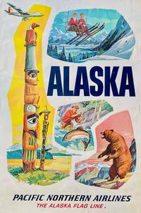
19508829Anchorage AK: Pacific Northern Airlines The Alaska Flag Line 1950. Color poster 91 cm x 61 cm / 36" x 24". Crease at lower left otherwise nice. Colors are vibrant and 'pop.'. Promotional poster from Pacific Northern Airlines advertising their service to Alaska that features a montage of illustrations depicting skiers a carved and painted totem a fisherman in action and a bear on its hind legs.<br /> <br /> In 1932 Arthur G. Woodley founded Woodley Airways flying routes across Alaska. In 1945 Woodley changed the name to Pacific Northern Airways and moved the company headquarters to Seattle. In 1951 Pacific Northern Airways was able to start running regular flights between Seattle and Anchorage and continued to operate these and its routes within Alaska until it was taken over by Western Airlines in 1967. Western Airlines continued to offer flights under the Pacific Northern Airlines branding through the early 1970s. Pacific Northern Airlines, The Alaska Flag Line unknown
188433877New York: Sackett 1884-1892. First Edition. 1884. 64pp. illuslarge fold map at rear. Orignal printed wrappers $100 1885. 40pp. illuslarge fold map at rear. Orignal printed wrappers $100 1887. 40 51pp. Original printed wrappers. $75 1892. 96pp. illus two large fold maps at rear. Original printed wrappers $100 Sackett unknown books
187634111New York: Erie Railway Company 1876. First Edition. 32pp. illus colored fold map at front; numerous full page illustration throughout. Original printed wrappers with the inside rear wrapper having a map of the route and the outside wrapper a view of Niagara Falls. Extracted from a bound volume. Rather scarce. Erie Railway Company unknown books
1856DEMO015982IWashington: Beverly Tucker 1856-7. First & Quarto edition. Hardcover. Fair. chromolithographs. 4to original sheep lacks t-pg. Ex libris U.S. House of Representatives. <br/><br/>Comprised of 5 reports by John Grubb Parke Albert Henry Campbell Thomas Antisell John Torrey Andrew Atkinson Humphreys. "This widely known work requires no comment - Cowan CALIFORNIA p.512." Illustrated with chromolithographs. Beverly Tucker hardcover
186133741Wash D.C.: Polkinhorn 1861. First Edition. 23pp. Orig ptd wrps. First ed. Signed in type at end: "Cincinnation Deals with California the Pacific Railroads Mexico Sandwich Islands etc. Scarce. Not in Eberstadt Decker Graff Cowan or Forbes Polkinhorn unknown books
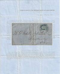
1857010681New York 1857. Envelope or Cover. Very good. This printed circular is titled “Transfer Office of the Southern Pacific Rail-Road Company / No. 54 Wall-Street / New York May 30 1857.†It is addressed to W. P. Mehville Wilne Esq. of Sandusky Ohio and franked with an imperforate Franklin stamp Scott #9 canceled by a black circular New York postmark. In nice shape with a tiny bit of soiling to the edges. </p> <br /> <br /> <p>The notice reads in part:</p> <br /> <br /> <p style="margin-left:5%; margin-right:10%;">“An installment of fifty cents a share will become due and payable on the three percent. Stock held by you in the Company on the first Monday of July next. . . Stock on which said instalment shall not be paid will be sold at auction in conformity with . . . the Charter. . .</p> <br /> <br /> <p style="margin-left:5%; margin-right:10%;">“About sixteen miles of our ‘Road’ are now graded and nearly furnished with cross-ties – twenty-four hundred and seventy-eight tons of rail-road iron have been bought and paid for and sent up Red River – sufficient to finish twenty-five miles of road.â€</p> . The Southern Pacific Rail-Road referenced in this document is not the much more famous transcontinental route. This railroad was founded on 16 February 1852 officially as the Vicksburg and El Paso Railroad although throughout the document it was referred to as the Texas Western Railroad. It was later bought by the Atlantic and Pacific Railroad for $600000. It was later acquired by Texas interests and its named officially changed to the Southern Pacific Railroad the predecessor of the Texas and Pacific Railway. It was never associated with the later and more famous transcontinental Southern Pacific.</p> <br /> <br /> <p>During 1857 the railroad laid 23 miles of track between Marshall and Swanson’s Landing on Caddo Creek. During the Civil War the line was connected to Shreveport Louisiana. In 1872 it was sold to the Texas Pacific Railroad Company which in 1976 merged with the Missouri Pacific Railroad.</p> <br /> <br /> <p>For more information see Werner’s “History of the Texas Western Railroad Companies†and “History of the Texas and Pacific Railway Company†both at the Texas State Historical Association website.</p> <br /> <br /> <p>Scarce. At the time of listing no other documents from this Southern Pacific Railroad are for sale in the trade. Although no other 1857 circulars documenting the construction of the first 16 miles of its track have been sold at auction other materials related to it have. OCLC shows no materials related to this Southern Pacific Railroad are held by institutions however it is possible there may some within the Texas & Pacific Railway Collection at the University of North Texas.</p> . unknown
56-0298Alameda County Calif.: County Surveyor 193 unfinished date. Map. Blueline print 37.5" x 39" with switching limits in red pencil. From Mento St and Dorchester Ave to Kent/Laurel Ave and Lake Chabot. Includes Rancho San Leandro Eden City lower portion of Brooklyn Township. Scale 1" = 500'. Alameda County, Calif.: County Surveyor 193? (unfinished date). unknown
56-0435Fresno Calif.: Progressive Map Service n.d. Blueline print 38" x 26" with red and black pencilling indicating track lines switching limits. From Marks Avenue to Willow Avenue and Annadale Avenue to Barstow Avenue. Includes City Directory street index approx 400 listings. Scale approx 1" = 1700'. Fresno, Calif.: Progressive Map Service, [n.d.] unknown
56-0436Fresno Calif.: Progressive Map Service Southern Pacific notations approved 1942. Blueline print 38" x 26" with red and blue pencil on map attached typewritten and handwritten memorandum indicating proposed extension. Marks Avenue to Willow Avenue and Annadale Avenue to Barstow Avenue. Includes City Directory street index approx 400 listings. Scale approx 1" = 1700'. Fresno, Calif.: Progressive Map Service, Southern Pacific notations approved 1942. unknown
56-0348San Francisco Calif.: Southern Pacific Company 1922 revised 1931. Map. Blueprint 24" x 36". From West Avenue to Oak Street and D Street to beyond Standard Oil Co. Inclues Index to Industries with approx 60 listings. Scale 1" = 400'. San Francisco, Calif.: Southern Pacific Company, 1922, revised 1931. unknown
56-0231San Francisco Calif.: Southern Pacific Company 1934. Map. Typewritten correspondence handwritten calculations and charts switching charges chart in 8 colors switching district and industrial maps rate and charge sheets. Includes circa 1928 map of Oakland Harbor. Harbor map: 19 x 47 inches. Scale: 1 inch = 1500 feet. Switching zone map: 22 x 28 inches. 25 pp. including inserts. San Francisco, Calif.: Southern Pacific Company, 1934. unknown
56-0234San Francisco Calif.: Southern Pacific Company 1931. Map. Blueline print. 24 x 48 inches. Map of Oakland Railroad Yard from Passenger Ferry to East Yard Limits. Includes list of nine transfers or cannonball moves and list of approximately 40 intersection/ DH correspondences. Scale: 1 inch = 1500 feet. San Francisco, Calif.: Southern Pacific Company, 1931. unknown
58-0502San Francisco Calif.: Southern Pacific Company 1948. Blueline print 28 inches x 22 inches. From Cutting Boulevard to Scott Avenue Lauritzen Canal to Fourteenth Street. Includes Parr Canal Shipways 1 - 7 HopCo Chemical Co Filice & Perrelli Canning. Scale 1 inch = 200 feet. San Francisco, Calif.: Southern Pacific Company, 1948. unknown
56-0213Tucson Ariz.: Southern Pacific Company 1932 revised 1949. Map. Blueline print. 24 x 48 inches. Includes passenger station railroad yard switches. Scale: 1 inch = 500 feet. Tucson, Ariz.: Southern Pacific Company, 1932, revised 1949. unknown
56-0438Fresno Calif.: Chamber of Commerce n.d. Blueline print 36" x 24" Marks Avenue to Willow Avenue and Annadale Avenue to Barstow Avenue. Red and yellow pencil shading highlight City Limits. With Central District map and street index approx 400 listings on back. Scale approx 1 inch = 0.3 mile. Fresno, Calif.: Chamber of Commerce, [n.d.] unknown
56-0363Tucson Ariz.: Pacific Motor Trucking Company 1932 revised 1934. Map. Blueline print 33.5" x 32.5" with red and green lines and circles indicating first morning and afternoon L.C.L. shipments from Los Angeles or Bay Area. From Colombia River at Pacific Ocean to El Paso. Scale approx 1 inch = 40 miles. Tucson, Ariz.: Pacific Motor Trucking Company, 1932, revised 1934. unknown
56-0362Tucson Ariz.: Pacific Motor Trucking Company 1949. Map. Blueline print 31" x 35" with red yellow and blue highlighting indicating Southern Pacific rail lines and Pacific Motor rights of passage. From Colombia River to El Paso. Scale approx 1 inch = 35 miles. Tucson, Ariz.: Pacific Motor Trucking Company, 1949. unknown
56-0449Oakland Calif.: Southern Pacific Company 1929 rev. 1949. Blueline print. 8 x 52 inches. From Sevier Avenue to Del Norte Avenue along railroad tracks. Includes Newbridge Park Henderson. Scale 1 inch = 100 feet. Oakland, Calif.: Southern Pacific Company, 1929, rev. 1949. unknown
56-0299Oakland Calif.: Southern Pacific Company 1960. Map. Blueline print 8" x 65" . Plan indicates railroad track communication wiring and two buildings. Includes Bishop Bros Warehouse Bishop Bros Wholesale. Scale 1" = 100'. Oakland, Calif.: Southern Pacific Company, 1960. unknown