Soley, RamonMareMagnum
Soldi FiorinoMareMagnum

Laura Guerra · Bologna, IT12,00 €
5 782 résultats
Two volumes, complete. The monumental catalogue raisonnÈ of maps and views of Barcelona printed from 1572 to 1900. LXXII, 1093 pp. with 740 large high-quality color plates. Text in Spanish, Catalan, and English. Edition limited to 1000 sets. Large oblong folio (31 x 44 cm). Publisher's cloth, with a design by Antoni T‡pies. FINE AND BRIGHT, WITH NO DEFECTS. As new.
370x310 mm. 122 pages. Hardcover with dust-jacket. Jacket edges torn and worn. Spine edges slightly rubbed. Pages slightly yellowing. Else in good condition.
Au sommaire, "Ecole et société en France": article de Jean-Michel CHAPOULIE sur l'école sous la IVè République; "Politiques et pratiques coloniales (XVIIIe-XXe siècles)": articles de Laurent DUBOIS et de Bernard CAMIER sur le théâttre des Lumières à Saint-Domingue, de Hélène BLAIS sur la cartographie en Algérie dans les années 1830-1840, de Romain BERTRAND sur la politique coloniale des Pays-Bas en 1880-1930, d'Eric JENNINGS sur l'émigration depuis Saint-Pierre et Miquelon en 1903-1939; comptes rendus d'ouvrages. Français
200713762Paris, Belin, 2007 1 volume 16 x 24cm Broché 191p. Très bon état.
Ril. in tela con sovr.a col., cm 39x31, pp 144, molte splendide tavv. e ill. a col.. - ISBN: 9023005635
1972134413New York u.a. Wiley & Sons, (1972). 4°. M. zahlr. Ktn. 158 S. OLwd. Kleberest v. Rsign. St. a. Tit.
1713Map868London: Henry Overton 1713. Original printed issues 1st Editions . No Binding. Fine. Folio. 1603-1713 The rare re-issue with amendments by Henry Overton of Smiths original plate of 1603. Based on the map by Saxton in 1573. Un-coloured example in fine condition of the copperplate engraving. Paper size 55 x 46 cms. Plate size 48 x 33 cms. No splits or holes. Plain verso and part of the original hinge still present. Table with a list of the hundreds. One of the original 'anonymous' maps that were identified as being by Smith in recent times.PLEASE EAMIL FOR PHOTOS. <br/> <br/> Henry Overton unknown
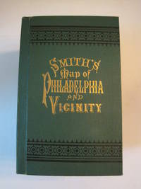
1894016609Philadelphia: J. L. Smith 1894. Fine condition. SEE PHOTOS. A very attractive well preserved copy of this detailed two-part map of Philadelphia and vicinity published in 1894 copyright 1893. Tough-to-find in collectible condition as nice as this. A bright clean copy. NO chips. NO tears. NO creases. NO owner's name or bookplate. Clean and unmarked. Drawn on a scale of 1 inch to the mile. The map consists of two parts. The eastern half unfolds to 23" wide by 27" tall. The western part is 21.5" wide by 27" tall. Both are skillfully and attractively hand colored. The maps are backed in linen as issued. They are housed in the publisher's original green cloth portfolio which is printed in black and embossed in gold on the front cover and in blind on the rear. Gilt lettering is still as bright and shiny as new. 1st ed No additional printings listed. Hardcover. Fine condition. J. L. Smith Hardcover
Includes six folded maps. 15x23 cm. 713 pages. Hardcover. Spine slightly faded. Chafe on inner cover. Ex-libris sticker on first white page. Pen writing on title page. Several pages slightly stained in edges. Else in good condition. PLEASE NOTE: This item is overweight. We may ask for extra shipping costs.
8°, 21 cm, pp. XI, 742, alcune figure nel testo, 42 tavole fuori testo, brossura editoriale illustrata, titolo al piatto e dorso, Collana: Biblioteca universale Laterza, esemplare ottimo
1823Map921London: C. Smith 1823. Corrected 3rd Edition . No Binding. Fine. Folding map. Original hand-coloured map dated 1823 58x50 cms. Double-page folding plate printed on fine paper and original hand-colour. With a numbered list of the Wapontakes including 8 examples found on this plate. A lovely example of the 3rd 1823 issue of the Jan 6th 1804 map by C. Smith of 172 The Strand London. Smith's County Altas being a complete set of County Maps divided into Hundreds. Wide margins no wear and very clean example with no marks or wear to the centre-fold. <br/> <br/> C. Smith unknown
Cartella in tela di cm. 17 X 11 contenente una grande pianta a colori (telata) di Londra più volte ripiegata di cm. 90 X 30 con divisioni in quartieri, misure delle distanze, linee tranviarie, ecc. oltre ad un indice dei nomi di 70 pagine. Ben conservata la cartella in tela rossa con titolo in oro e impressioni a secco al piatto.
1374000Koweït: Centre de recherches et d'études koweitiennes, 2005 in-4, 193 pages, 82 planches en couleurs. Bibliographie. Reliure d'éd., jaquette, très bon état. Histoire de la cartographie du Koweith.
NOTE : Volume TWO ONLY 101p. maps index Book
The first two lectures in this important series. 8vo. Original wraps. FINE AND BRIGHT.
Folio 291p., illus. Hardcover Very good condition good
Large quarto / small folio in maroon cloth boards an pink illus DJ; viii, 80 p. 84 plates (part col.) 29 cm; bibl. Early maps -- Facsimiles. Early maps.
Book has slight soiling to textblock. Dustjacket is price-clipped. DJ has small tears to corner and chipping to spine ends. Light soiling to DJ. ; Evidence concerning the Viking discovery of North America in the tenth and eleventh centuries is so incomplete, investigation of this area of history will be substantially aided by the discovery of new documents. Such is the claim made for the previously unknown manuscripts here published for the first time. They are two documents copied about 1440 from much earlier originals, now lost. The first is an account of Friar John of Plano Carpini's mission to the Mongols in 1245-47. The second is a world map, including the western ocean, with delineations of Iceland, Greenland, and a land mass named Vinland which represents the North American mainland as known to the medieval Norsemen. This map is the earliest known and indisputable cartographic representation of any part of the Americas. As the editors show, the Tartar Relation provides information on Mongol history and legend not to be found in any known source, and a portion of the Map represents the only surviving medieval example based on Norse cartography - a conclusion with far-reaching implications for the history of cartography and of the Viking navigations. OVERSIZED. ; 291 pages
4to [28.5 x 22 cm]; xii, 337 pp, color frontis, more than 200 illustrations of maps, charts and drawings from early sources, bibliog, index. original cloth, title lettering on spine, dj (spine faded from sun but lettering clear, slight wear at spine ends), signature on endpaper but very good copy. A picture of this book is available upon request by email. An excellent and most useful book, by the former chief of the Map Room at the British Museum whose book are highly respected. This book traces the development of cartography from medieval times to the present and discusses the European exploration and discovery of the rest of the world. Parts of the book were published in Geographic Magazine in a different form. This edition is in larger format than previous edition, making it easier to read.
1967018898London: Map Collectors' Circle 1967. Complete with errata slip laid in. Near Fine condition. Clean and unmarked. NOT a library discard. NO owner's name or bookplate. Describes in detail 23 main entries plus variants. Includes collations. Lists all charts and maps. Cross referenced to Phillips. Illustrated with 22 plates 1 fold-out. Bound in the original tan wraps printed in black. 7.25" wide by 9.75" tall. First Edition. Softcover. Near Fine condition. 50pp. Great Packaging Fast Shipping. Map Collectors' Circle Paperback
In 4° piccolo; 11, (5) pp. e una grande tavola più volte ripiegata. Brossura editoriale. Perfetto stato di conservazione. Prima ed unica edizione di questo repertorio bibliografico-cartografico dedicato agli spicchi componenti un globo terrestre realizzato a Venezia intorno al 1570.
Roy. 4to., First Edition, with 12 coloured plates and 72 monochrome plates; burgundy cloth, upper board blocked in gilt, gilt back, a very good, bright, clean copy. The first form of this work, by Humphreys, appeared in 1926 designed as a picture book to illustrate the wealth of a notable collection. Skelton's classic reworking serves both as a specimen book and a guide to the study of maps printed from wood blocks or copper-plates from the birth of mapmaking to the eve of scientific cartography. The majority of plates in the original work have been retained and twenty-two new illustrations added, together with a bibliography.
4to, viii,262pp., frontis., 40 plates, facsimiles, orig. cloth.
4to, viii,262pp., frontis., 40 plates, facsimiles, orig. cloth, d.w.