333 résultats
1805Map958Paternoster Row London: Longman Hurst Rees & Orme 1805. 1st Edition 1st Printing. No Binding. Fine. Original early 19th century MAP of ALPINE COUNTRY from Barvaria to N. Italy. On MERCATORS PROJECTION BY AARON ARROWSMITH. A FINE AND DARK IMPRESSION. Original folding plate printed on heavy paper dated 1804. A scarce example and in fine un-coloured original condition. SOME MARGINAL FOXING. 41x27cms. Double-page folding map.A NICE COPY <br/> <br/> Longman, Hurst, Rees & Orme unknown
1769MAP1047London: Russell and Price 1769. Original Map . No Binding. Vg. 4to. Single page map of DEVONSHIRE. T.Kitchen. Published in ENGLAND DISLAYED Being a New Complete and Accurate Survey and Description of the Kingdom of England and Principality of Wales. Plate 19x27 cm sheet 243 x 160mm Fine original map printed on laid paper. Uncoloured. 2ND EDITION pub. 1769. OTHER COUNTIES ARE AVAILABLE FROM THIS ISSUE. <br/> <br/> Russell and Price unknown
1769MAP1045London: Russell and Price 1769. Original Map . No Binding. Vg. 4to. Single page map of OXFORDSHIRE T.Kitchen. Published in ENGLAND DISLAYED Being a New Complete and Accurate Survey and Description of the Kingdom of England and Principality of Wales. Plate 19x27 cm sheet 243 x 160mm Fine original map printed on laid paper. Uncoloured. 2ND EDITION pub. 1769. OTHER COUNTIES ARE AVAILABLE FROM THIS ISSUE. <br/> <br/> Russell and Price unknown
1769MAP1043London: Russell and Price 1769. Original Map . No Binding. Vg. 4to. Single page map of Yorkshire T.Kitchen. Published in ENGLAND DISLAYED Being a New Complete and Accurate Survey and Description of the Kingdom of England and Principality of Wales. Plate 19x27 cm sheet 243 x 160mm Fine original map printed on laid paper. Uncoloured. 2ND EDITION pub. 1769. OTHER COUNTIES ARE AVAILABLE FROM THIS ISSUE. <br/> <br/> Russell and Price unknown
1769MAP1048London: Russell and Price 1769. Original Map . No Binding. Vg. 4to. Single page map of DORSETSHIRE. T.Kitchen. Published in ENGLAND DISLAYED Being a New Complete and Accurate Survey and Description of the Kingdom of England and Principality of Wales. Plate 19x27 cm sheet 243 x 160mm Fine original map printed on laid paper. Uncoloured. 2ND EDITION pub. 1769. OTHER COUNTIES ARE AVAILABLE FROM THIS ISSUE. <br/> <br/> Russell and Price unknown
1769MAP1040London: Russell and Price 1769. Original Map . No Binding. Vg. 4to. Single page map of CARDIGANSHIRE T.Kitchen. Published in ENGLAND DISLAYED Being a New Complete and Accurate Survey and Description of the Kingdom of England and Principality of Wales. Plate 19x27 cm sheet 243 x 160mm Fine original map printed on laid paper. Uncoloured. 2ND EDITION pub. 1769. OTHER COUNTIES ARE AVAILABLE FROM THIS ISSUE. <br/> <br/> Russell and Price unknown
1769MAP1046London: Russell and Price 1769. Original Map . No Binding. Vg. 4to. Single page map of CORNWALL T.Kitchen. Published in ENGLAND DISLAYED Being a New Complete and Accurate Survey and Description of the Kingdom of England and Principality of Wales. Plate 19x27 cm sheet 243 x 160mm Fine original map printed on laid paper. Uncoloured. 2ND EDITION pub. 1769. OTHER COUNTIES ARE AVAILABLE FROM THIS ISSUE. <br/> <br/> Russell and Price unknown
1769MAP1042London: Russell and Price 1769. Original Map . No Binding. Vg. 4to. Single page map of Cheshire T.Kitchen. Published in ENGLAND DISLAYED Being a New Complete and Accurate Survey and Description of the Kingdom of England and Principality of Wales. Plate 19x27 cm sheet 243 x 160mm Fine original map printed on laid paper. Uncoloured. 2ND EDITION pub. 1769. OTHER COUNTIES ARE AVAILABLE FROM THIS ISSUE. <br/> <br/> Russell and Price unknown
1769MAP1049London: Russell and Price 1769. Original Map . No Binding. Vg. 4to. Single page map of SOMERSETSHIRE. T.Kitchen. Published in ENGLAND DISLAYED Being a New Complete and Accurate Survey and Description of the Kingdom of England and Principality of Wales. Plate 19x27 cm sheet 243 x 160mm Fine original map printed on laid paper. Uncoloured. 2ND EDITION pub. 1769. OTHER COUNTIES ARE AVAILABLE FROM THIS ISSUE. <br/> <br/> Russell and Price unknown
1769MAP1038London: Russell and Price 1769. Original Map . No Binding. Vg. 4to. Single page map of BUCKINGHAMSHIRE G. Rollos. Published in ENGLAND DISLAYED Being a New Complete and Accurate Survey and Description of the Kingdom of England and Principality of Wales. Plate 16x20 cm sheet 160 x 243mm. VG original map printed on laid paper. SOME MOTTLING. Uncoloured. 2ND EDITION pub. 1769. OTHER COUNTIES ARE AVAILABLE FROM THIS ISSUE. <br/> <br/> Russell and Price unknown
1769MAP1039London: Russell and Price 1769. Original Map . No Binding. Vg. 4to. Single page map of BERKSHIRE G. Rollos. Published in ENGLAND DISLAYED Being a New Complete and Accurate Survey and Description of the Kingdom of England and Principality of Wales. Plate 16x20 cm sheet 243 x 160mm. VG original map printed on laid paper. Uncoloured. 2ND EDITION pub. 1769. OTHER COUNTIES ARE AVAILABLE FROM THIS ISSUE. <br/> <br/> Russell and Price unknown
1769MAP1037London: Russell and Price 1769. Original Map . No Binding. Vg. 4to. Single page map of ANGELSEY G. Rollos. Published in ENGLAND DISLAYED Being a New Complete and Accurate Survey and Description of the Kingdom of England and Principality of Wales. Plate 16x20 cm sheet 160 x 243mm. VG original map printed on laid paper. SOME MOTTLING. Uncoloured. 2ND EDITION pub. 1769. OTHER COUNTIES ARE AVAILABLE FROM THIS ISSUE. <br/> <br/> Russell and Price unknown
1832Pa402London: A. Arrowsmith and B. Fellowes 1832. 1st Edition . Hardback. Vg. 12mo. Engraved title engraved index and 19 engraved maps with outline colour lower half of Italy lacking. Double page and folding maps. Some edges of folds split. Original binding with detached front board. The ancient world by Arrowsmith 'Hydrographer to the King' William IV <br/> <br/> A. Arrowsmith and B. Fellowes hardcover
1837TS145London: Longman & Co. 1837. 1st Edition . original half red morocco. Grubby. octavo. 23 attractive double page maps of the ancient world with outline hand-colouring. Index. A scruffy original binding but with clean maps. <br/> <br/> Longman & Co. unknown
1960508064Praeger 1960. First Edition. Hardcover with Dust Jacket. NEAR FINE/NEAR FINE. 10 11-126pp. 12mo sewn binding in black cloth gilt spine lettering. Illustrated throughout with Horrabin's hand-drawn maps and pithy political and historical commentary on facing pages. Owner's name to FFEP and some very faint toning to the endpapers exceedingly clean and sharp otherwise; DJ with a short tear and creasing to rear head clean and bright otherwise and now wrapped in mylar. A lovely book by the famed Socialist Cartographer and illustrator showing aspects of ancient and colonial eras with a particular interest in the African Nationalist movement then hotly active; final publication before his death in 1962. Praeger hardcover
1808Map941Paternoster Row London: Longman Hurst Rees & Orme 1808. 1st Edition 1st Printing. No Binding. Fine. Original early 19th century map MAP OF ARABIA BY AARON ARROWSMITH. A FINE CLEAN AND DARK IMPRESSION. Original folding plate covering THE WHOLE OF ARABIA printed on heavy paper dated 1808. A scarce example and in fine un-coloured original condition. An occasional light foxing mark. 41x27cms. Double-page folding map.Engraved by Cooper.A LOVELY COPY <br/> <br/> Longman, Hurst, Rees & Orme unknown
1806Map954Paternoster Row London: Longman Hurst Rees & Orme 1806. 1st Edition 1st Printing. No Binding. Fine. Original early 19th century map MAP OF ASIA BY AARON ARROWSMITH.A FINE CLEAN AND DARK IMPRESSION. Original folding plate printed on heavy paper A scarce example and in fine un-coloured original condition. An occasional light foxing mark. 41x27cms. Double-page folding map. Engraved by Edw. Jones.A LOVELY COPY. Imprint date May 6th 1806. <br/> <br/> Longman, Hurst, Rees & Orme unknown
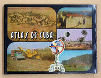
94117La Habana 1978. Quer-Gr8° 143 S. mehrfarbige Karten 3 Bl. 9 Bl. Indice OLwd. m. OU in Schuber Min. fleckig TADELL. Text: spanisch. 010 La Habana, 1978 unknown
2011668069.Gpaperback. Good. Access codes and supplements are not guaranteed with used items. May be an ex-library book. paperback
198713336Norman OK USA: University of Oklahoma Press 1987. First Edition Second Printing. Paperback. Very Good/No Dust Jacket. Large paperback no marks many maps and illustrations with 224 pages. <br/><br/> University of Oklahoma Press paperback
1868016331New York: F. W. Beers; A.D. Ellis; G.G. Soule 1868. Near Fine condition. NO chips. NO tears. A bright clean tight copy. The spine is square and flat with NO creases. NO owner's name or bookplate. Pages are bright white clean and crisp. This is an undated modern facsimile of the 1868 original. Oversize Softcover with black cloth spine. 10.75" wide by 14" tall. This atlas consists of a printed title-page; an outline map of Morris County; 31 single and double-page maps; a Table of Distances for Morris County; and 2 pages of lithographic views of 6 buildings George Washington's Headquarters in 1779/80; Boonton Academy; Schooley's Mountain Seminary; etc. Included are maps of: Washington; Chester; Mendham; Brookside; Stephensburg; Whippany; Morris; Morristown; Passaic; Green Village; New Vernon; Chatham; Madison; Troy; Hanover; Chatham Long Hill; Parsippany; Roxbury; Drakesville; Randolph; Dover; Oram; Jefferson; Flanders; Milton; German Valley; Schooley's Mountain; Rockaway; McCainsville; Succasunny; Hanover; Boonton; Montville; Boonton Borough; and Pequannock. Laid in is a facsimile of an old map of Morristown scale: 20 rods to the inch that unfolds to 22" wide by 25" tall. The map is keyed to the locations of Morristown businesses such as livery stables markets boot and shoe sellers manufactures physicians hotels editors merchants etc. This large book will require extra postage for Priority and International shipments but only the standard charge for media mail. Facsimile Edition. Oversize Softcover. Near Fine condition. Unpaged but 64 pages. F. W. Beers; A.D. Ellis; G.G. Soule Paperback
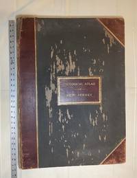
1889028277New York: Julius Bien & Co 1889. Condition of the binding is only Fair with pest damage. Leather over the spine has perished. Front and rear outer hinges cracks have been neatly reinforced with high quality clear flexible glue. Inner hinges are OK having been reinforced by the publisher/bookbinder with sturdy maroon cloth. SEE PHOTOS. Condition of all maps is NEAR FINE - FINE. NO foxing or toning. Pages are clean and unmarked. SEE PHOTOS. Includes a title page map of New Jersey Key to the System of Mapping and 19 linen-backed double page maps. Collated and complete per table of contents -- SEE PHOTOS. The maps are lithographically printed in blue red yellow and black. The double page maps open to an impressive 26.50" across by 36.50" tall. No year of publication is stated but Phillips 2149 in A LIST OF GEOGRAPHIC ATLASES Vol. 1 says 1889. The maps themselves are variously dated up to 1888. Titles of Sheets: No. 0. New Jersey State Map Geographic; No. 1. Kittatinny Valley and Mountain No. 2. Southwestern Highlands; No. 3. Central Highlands; No. 4. Northeastern Highlands; No. 5.Vicinity of Flemington; No. 6. Valley of the Passaic; No. 7. The Counties of Bergen Hudson Essex No. 8. Vicinity of Trenton; No. 9. Monmouth Shore; No. 10. Vicinity of Salem No. 11. Vicinity of Camden; No. 12. Vicinity of Mount Holly; No. 13. Vicinity of Barnegat Bay; No. 14. Vicinity of Bridgeton; No. 15. Southern Interior; No. 16. Egg Harbor and Vicinity; No. 17. Peninsula of Cape May; Unnumbered map. "New Jersey from Original Surveys based on the Triangulation of the U.S. Coast and Geodetic Survey Relief Map." Scale of first and last doublepage maps: 5 miles to an Inch. Scale of maps No. 1 to No. 17: 1 mile to an Inch. Bound in black pebble-grain cloth with gilt-stamped brown leather title label leather spine and corners leather backstrip has perished. SEE PHOTOS. The textblock could be easily rebacked or recased with no re-sewing required since all pages/maps are still securely bound together. Oversize Hardcover. 19.50" wide by 27" tall. This massive extremely heavy book will require SUBSTANTIAL extra postage at our cost based on your location. LeGear ATLASES OF THE UNITED STATES L5609. See also Schwartz and Ehrenerg's THE MAPPING OF AMERICA pp. 310-311. Phillips 2149. This massive extremely heavy book will require SUBSTANTIAL extra postage at our cost based on your location. Second Edition. Oversize Hardcover. Fair - FINE condition. Illus. by NOT a library discard. Atlas folio. Great Packaging Fast Shipping. Julius Bien & Co Hardcover
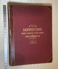
1910028278Philadelphia Pennsylvania: A. H. Muller Publisher 1910. Condition of the binding is Good but for rubbing at the corners and outer hinges cracked. SEE PHOTOS. Inner hinges are PERFECT having been reinforced by the publisher/bookbinder with sturdy maroon cloth. Housed in a Fine custom-made maroon cloth-covered clamshell case. SEE 2 PHOTOS its outside and both inner halves when opened. Condition of all maps is NEAR FINE - FINE. Pages are clean and unmarked. NO tears or foxing. SEE PHOTOS. This atlas consists of 25 i. e. 26 counting the Index map hand-colored lithographic linen-backed double page maps. The maps are color-keyed to the locations of each of the following: stone buildings brick buildings frame or half frame buildings stables or barns green houses steam railroads electric railroads water pipes sewers improved roads and fire hydrants. SEE PHOTOS. The double page maps open to an impressive 31.50" across by 22.25" tall. Each map did have a maroon leather numbered tab i. e. Index and 1-25 however the numbers for tabs 15-19 are broken/missing. SEE PHOTOS. Full title: "Atlas of Part of Morris Co. N. J. Embracing Town of Morristown The Boroughs of Madison Florham Park Chatham and Mendham: Morris Township and Parts of Chatham Hanover Mendham and Passaic Townships compiled from actual surveys official records and private plans by J. M. Lathrop and Thomas Flynn Civil engineers. Under the direct management and supervision of A. H. Muller Publisher 530 Locust Street Philadalphia PA. 1910." Collated and complete per table of contents. Includes a STREET INDEX. Bound in the original maroon cloth with maroon leather spine and corners. Gilt-stamping is still bright. SEE PHOTOS. The textblock could be easily rebacked with no re-sewing required since all pages/maps are still securely bound together. Oversize Hardcover. 17" wide by 22.50" tall. This massive extremely heavy book will require SUBSTANTIAL extra postage at our cost based on your location. LeGear ATLASES OF THE UNITED STATES L2343. Phillips A LIST OF GEOGRAPHIC ATLASES 3834. First Edition. Oversize Hardcover. Good - Fine condition/Fine clamshell case. Illus. by NOT a library discard. Atlas folio. Great Packaging Fast Shipping. A. H. Muller, Publisher Hardcover
2005b1150<p>University of California Press 2005. XIV150 pages. New Hardcover. NearFine DJ. Oblong. 12.0"x9.25"x1.0". be6</p> University of California Press hardcover
1834Map893London: Greenwood 13 Regent Street Pall Mall 1834. 1st Edition . Hardback. Fine. Elephant Folio - over 15" - 23" tall. A fine large ATLAS with 44 of 46 lacking Suffolk and lacking Norfolk double page maps bound with central hinges. Clean paper with little off-setting foxing tanning or marks. Decorative double page engraved maps of the counties with an uncoloured vignette views. Fine elegant engraved titles Original hand-colour block and outline. 65 x 80.5 cms 25 1/2 x 31 3/4 inches printed on thick paper with wide clean and fine margins. Printed July 4th 1829 and published in the C& J Greenwoods "Atlas of The Counties of England" dated 1834. SPINE LACKING AND THE BOARDS DETACHED. PLEASE EMAIL FOR PHOTOS. <br/> <br/> Greenwood, 13 Regent Street, Pall Mall hardcover