(Mexican Railroad) Primer, PawelBiblio.com
10 874 résultats
1881372908Mexico 1881. Manuscript map pen-and-ink and wash on onion skin paper. 15-1/2 x 20 inches. Folds and creases. Manuscript map pen-and-ink and wash on onion skin paper. 15-1/2 x 20 inches. Depicts the route of a railroad from Mexico City to Puente de Ixtla then north west to Toluca and west to Tancitaro with proposed transecting routes to connect the railroad from Pazo on the Atoyac River to Gihuatenejo on the Pacific coast. Pawel Primer evidently served as an engineer on the proposed railroad and this manuscript map was likely an addenda to a report issued to solicit investment in the project. The BNF holds two manuscript plans by Primer relating to archaeological sites. unknown
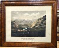
1900P5495Canada: Canadian Pacific Railway c.1900. Very Good . Notes: View of Banff Springs Hotel and Bow River Valley National Park-Rocky Mountains. It is framed in its original frame. <br>The Fairmont Banff Springs formerly and commonly known as the Banff Springs Hotel is a historic hotel in western Canada located in Banff Alberta. Image Size : 404x528 mm 15.91x20.79 Inches Platemark Size : Paper Size : 550x692 mm 21.65x27.24 Inches Coloring: Hand Colored Medium: Offset Lithograph Categories: Views Canada Alberta & British Columbia; Canadian Pacific Railway unknown
184829072New York: Van Norden 1848. The 1st annual report of the Hudson River Railroad not recorded on OCLC. Early reports authorizing the construction of the railroad from NY to Albany are dated 1848; the 2nd Annual Report of the Directors of the Hudson River Railroad is dated August 1849 <br /> The New York & Harlem Railroad NY&H was incorporated in 1831 to build a line in Manhattan from 23rd Street north to 129th Street between Third and Eighth Avenues the railroad chose to follow Fourth Avenue. At first the railroad was primarily a horsecar system but in 1840 the NY&H's charter was amended to allow it to build north toward Albany. In 1844 the rails reached White Plains and in January 1852 the NY&H made connection with the Western Railroad later Boston & Albany at Chatham New York creating a New York-Albany route. The Hudson was a busy river and the towns along it felt no need for a railroad - except during the winter when ice prevented navigation. Poughkeepsie interests organized the Hudson River Railroad in 1847. <br /> <br /> 8vo 24 page pamphlet. Printed paper wrappers one folding sheet of statistics tipped-in. Ex-lib with Hamilton College Library stamp and catalog numbers at front cover and slt foxing internally o/w very good. A fascinating first look at the Hudson River Rail line with the progress to date" now about 3000 men working between this city and Poughkeepsie the most of them between the city and Breakneck hill." p2. Van Norden unknown
1851406078New York: Wm. C. Locke & Co 1851. Wrappers chipped at edges professionally rebacked some unobtrusive offsetting on map. 8vo. 50 pages. Large folding map on three joined sheets 21 x 1788 cm; 8.25 x 61.75 inches. 11 woodblock illustrations in text and with 2 more not recorded in the index but always present. Original printed wrappers with woodblock vignette. SCARCE Hudson River Railroad travel guide published the first year in which the full line was completed. It covers points of interest along the route with woodblocks illustrating the text. Topics include: the history of the Hudson River the history of the construction of the Hudson River Railroad and the cities towns and villages along the Hudson from New York City all the way to Troy. Concerning the West Point Foundry at Cold Spring the guide states: "the iron foundry was established here by Gouverneur Kemble. The works are situated about a mile west of the village upon a small stream which tumbles rapidly down the mountains affording considerable water power. It is the largest establishment of its kind in the country employing nearly five hundred hands constantly." The building of the Hudson River Railroad is another topic in the guide. The project was considered highly impractical since much of the route had to be cut through extremely difficult rock and terrain. This section includes a description of the tunnels which had to be constructed. The railroad was opened in three stages. In September 1849 it allowed passengers to travel from New York to Peekskill. By that December 6 twenty-three additional miles were opened extending to New Hamburg. By the 31st of the month it was open the remaining distance of nine miles to Poughkeepsie. The Hudson River Railroad was an extension of the Troy and Greenbush Railroad which was chartered in 1845 connecting Troy South to Greenbush now Rensselaer on the east side of the Hudson. The Hudson River Railroad was chartered on May 12 1846 to extend this line south to New York City. The full line opened on October 3 1851 the same year in which this travel guide was published. WorldCat/OCLC records 25 copies but it is scarcely found complete with the map and the map is also excluded from the digitized versions available online. <br/><br/> Wm. C. Locke & Co unknown books
187044035Omaha: Land Department Union Pacific Railroad Company 1870. 1870. First edition. First edition. 8vo. 8 3/4" x 5 3/4" printed wrappers with map on back cover 44 pp. introduction illustrated maps. The rear cover features a map of portions of Idaho Utah Wyoming Colorado Dakota Nebraska Kansas Missouri and Iowa. States where land grant bonds are available from the Union Pacific Railroad Company. The frontispiece is a map of the United States that shows the Union Pacific Railroad and its connections. A third map shows counties in Nebraska in 1870 and the Union Pacific Railroad lands first 200 miles grants of 1862-64. A description of the Nebraska lands are provided county by county. The available lands are contained in alternate sections of one square mile each within a breadth of twenty miles on either side of the railroad and extend along the entire line. They extend through central Nebraska southern Wyoming and northern Colorado and Utah and include within their limits the splendid agricultural lands of the Platte Valley the great natural pastures of the Laramie Plains and the valleys of Lodge Pole Creek and Bear River and the rich iron and coal fields between the Black Hills and the Wahsatch Mountains. Description advantages water resources climate soil live stock raising farming markets timber minerals information about homesteads advantages of living in colonies etc. Both Adams' Herd and Graff list similar titles but different years and claim their listings to be "rare." A small bump to the top edges light wear to the spine ends else a near fine copy. Land Department Union Pacific Railroad Company, 1870. unknown
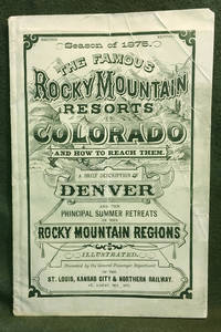
18757<b>A BRIEF DESCRIPTION </b><b>OF THE </b><b>FAMOUS ROCKY MOUNTAIN RESORTS </b><b>IN </b><b>COLORADO </b><b>and </b><b>HOW TO REACH THEM.</b><b><br />Compiled by the General Passenger and Ticket </b><b>Department of the St. Louis Kansas City &</b><b>Northern Railway</b><b><br />Season of 1875 </b><b>Illustrated </b><b><br /></b><b>COLORADO TERRITORY</b><b><br /></b><b>Publication dimensions: 4-3/4 inches by 7-3/8 inches; </b><b>52 pages </b><b><br /></b><b>Second Edition </b><b><br /></b><b>Including "Map of the Principal Resorts of Colorado" </b><b>on Page 22: </b><b>Supplement to "Guide Through Colorado" </b><b>Foldout engraving in front of publication by Arthur Lumley </b><b>"Famous Resorts in the Rocky Mountain Regions </b><b>Colorado" </b><b><br /></b><b>Dimensions: 17-1/2 inches by 11 inches </b><b><br /></b><b>Very good plus to near fine condition: some creasing on front cover; folded once vertically in distant past; interior pages clean bright and sturdy; folded engraving in near fine condition.<br />Historical Colorado railroad guide and map exhibited by: <b><b>COLORADO ARTIFACTUAL </b></b><b><b>& </b></b><b><b>MT. GOTHIC TOMES</b></b></b> General Passenger and Ticket Department of the St. Louis, Kansas City & Northern Railway
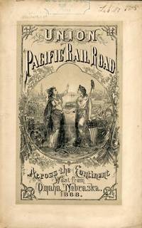
186854323New York: Published by the Company 1868. 1868. TRANSCONTINENTAL RAILROAD. First edition. Pamphlet edition. 8vo. Pictorial wrappers 40 pp. frontispiece Map of the Union Pacific Rail Road and its Connections introduction illustrated frontispiece map advertisement on rear cover for "First Mortgage Bonds at 102 principal and interest payable in gold with an annual income of "between eight and nine percent." This is an investment and advertising booklet for the first transcontinental railroad in the United States which was built by the Union Pacific Railroad and the Central Pacific Railroad in order to connect the Atlantic and Pacific coasts by rail for the first time. Begun in July of 1865 and built primarily by Civil War veterans the construction and completion of the Union Pacific line was one of the most significant technological and economic accomplishments of the 19th century creating the vital connection for commerce trade and travel and literally joining the eastern and western halves of the United States. Contents include the formation of the Union Pacific Railroad Company progress natural resources construction branch and connecting roads construction resources anticipated business & profits actual earnings and sale of first mortgage bonds. A list of officers of the company is provided. Top of front cover displays that this copy is mildly ex-library with stamp and number appearing at the upper right side a faint vertical fold to the center of the booklet tiny chips to bottom corner of front cover and a few preliminary pages. Overall a very good copy of an important railroad report. Published by the Company, 1868. unknown
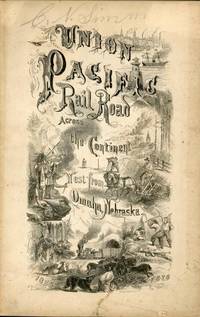
186754322New York: Brown & Hewitt Printers 1867. 1867. TRANSCONTINENTAL RAILROAD. First edition. Pamphlet edition. 8vo. Pictorial wrappers 24 pp. frontispiece Map of the Union Pacific Rail Road and its Connections introduction illustrated frontispiece map advertisement on rear cover for "First Mortgage Bonds at six per cent. In gold at Ninety Cents on the Dollar. Light evidence of the entire booklet having been folded vertically penciled name to top of front cover covers lightly soiled and used small closed tear to the lower margin of the front cover Overall a very good copy of an important railroad report. Brown & Hewitt, Printers, 1867. unknown
58754Kell Bros. Chromo Litho Castle St. Holborn London. 1863. The lithograph shows the interior of Baker Street Station groups of passengers on opposite platforms and a steam train entering the station. The rail track has three lines one of which was provided in order to allow both narrow and broad gauge railway engines to use the system. The mount is discoloured by age chipped and worn at the edges and with a semi-circular mark in one margin. The surface of the lithograph has a few very small surface scratches visible in the image provided otherwise a finely coloured and evocative print. The underground railway station at Baker Street was opened on January 10th. 1863 one of the original stations of the Metropolitan Railway the world's first underground railway line opening for traffic in 1863. Thus 2013 sees the 150th. anniversary of that occasion ! The North Metropolitan Railway the original name of the Metropolitan Railway was incorporated in 1853 in order to establish a line from the Great Western Railway terminus at Paddington to Farringdon plus the provision of a connection to the Great Northern Railway at King's Cross. Traffic in London by mid-century had reached overwhelming levels. The beginnings of industrialisation had brought an influx of workers into London many of whom by this time were forced to find homes on the periphery on land that had once been agricultural. London's food and other materials had now to be brought in from further away and workers had to either walk into London or be taken by horse-drawn transport. By 1860 it has been estimated that London had a population of over 300000 horses for whom stabling was required feed had to be brought in and manure taken out. In addition to this colossal call upon the street system by 1850 some two and a half million cattle sheep pigs and poultry were driven to the London markets and abbatoirs. Together this was a potent impetus for the development of the railway. Work on the Metropolitan line was started in February 1860 using the "cut-and-cover" method of construction the first section of which ran between Paddington and Farringdon Street in January 1863. Later that year the decision was made to link the surface main-line terminals by an underground railway. The Baker Street station owned by the Metropolitan Railway Company was one of the first stations on the first underground railway line. Kell Brothers were engravers and printers in Castle Street Holborn London specialising in lithographic prints. They were active from 1860 to the early 1870s. In 1860 the firm advertised in The Times "TO LITHOGRAPHERS. - WANTED good DRAUGHTSMEN and WRITERS." They contributed to the first volume of The Architectural Dictionary published in 1862 and produced a wide range of material including topical scenes such as the new Metropolitan Railway station at Baker Street opened in 1863. In 1870 the firm participated in the competition run by the Art Union of London with chromo-lithographs of Belagio-Como from an original drawing by Birkett Foster. WIKI. References Kell Bros. Chromo Litho, Castle St., Holborn [London]. [1863?]. unknown
193259163New York NY & Swissvale PA: Westinghouse Union Switch & Signal Co.; New York City Transit Authority Transit Commission 1932. Oblong 4to. 11.5 x 8.75 in. 40 leaves unnumbered. including 20 typescript explanatory leaves on onion-skin paper 20 linen-backed silver gelatin photographs all w/ Union Switch & Signal Co. in lower blank fore-edges all w/ rounded corners sized 8 x 10 in. mounted on linen hinges. Original flexible simulated black calf post-binder ownership name stamped on lower right corner front cover very slight fraying at fore-edges slight wear NF exemplar from library of Transit Commissioner Chairman John H. Delaney 1871-1952. This souvenir photo album documents the key switch and signal control systems power equipment subway signals car brake tripper valves and signal systems and more for the newly opened 8th Avenue IND Subway line in New York running from 207th St. to south of High St. in Brooklyn Heights. George Westinghouse had pioneered airbrake safety equipment revolutionizing rail travel in the 19th Century and had absorbed and created the Union Switch & Signal Co. in 1881 moving to Swissvale in 1887 where the subsidiary specialized in specifically closed track circuits and interlocking switch and signal control systems vital for interurbans subway systems and other rail lines. This album depicts the large signal control panel illuminated track indicator switch operating mechanisms and control valves tripper mechanisms signal control cables apparatus housing Dwarf subway interlocking signals and more. In addition many of the images reveal the newly constructed subway tunnels control rooms switching rooms air compressor plants and storage buildings. The 8th Avenue line was originated under Mayor John Hylan who pursued an independent subway system and directed Transit Commission Chairman Delaney to oversee construction and implementation of the line with most of the line dug using the cut-and-cover method by excavating the street above and attempting to avoid existing lines and stations. Delaney had begun his career managing the Morning Telegraph and the printing plant owner and was tapped in 1913 by Gov. Suizer as Commissioner of Efficiency and Economy during the Progressive Era. He proved to be an essential figure in not only overseeing the eventual $ 770 million job of building the IND subway system but was also key to the eventual unification of the IRT and BMT subway systems purchased by New York City for $ 326 million. No similar albums or photo archives located in Worldcat or other relevant institutional holdings; See: J.H. Delaney Dies; Ex-Transit Head The Brooklyn Dailey Eagle Aug. 14 1952 pp. 1 & 9; Steven Usselman Air Brakes for Freight Trains: Technological Innovation in the American Railroad Industry 1869-1900 The Business History Review Vol. 58 No. 1 Transportation Spring 1984 pp. 30-50. Westinghouse, Union Switch & Signal Co.; New York City Transit Authority, Transit Commission, unknown
190558599London England: Great Western Railway ca. 1905. Oblong 4to. 11 x 8 in. 48 pp unpaginated. on thick card stock all leaves mounted on linen hinges w/ 38 original albumen & silver gelatin photographs mounted all sized from 6 x 8.25 in. and all with very strong contrast and bright images. Contemporary embossed green cloth over beveled boards ruling in blind minor shelfwear light bumping to couple corners very light occasional interior toning still NF exemplar. This exceptional Edwardian factory photo album offers contemporary images of several classes of steam locomotives purchased and operated by the Great Western Railway under the direction of both William Dean and G.J. Churchward. The images primarily focus on the 4-4-0 Express engines including the “City Class†‘Badminton Class†GWR 4100 “Atbara Class†“Bulldog Class†and the “Saint Class.†Photos depict such storied locomotives as the William Dean No. 100 built in 1902 and fore-runner of the 4-6-0 locomotives on the Great Western Railway which were 2-cylinder machines built with parallel boilers; the Vanguard 4-4-0 later renamed Cunard was designed at behest of Churchward and based on the William Dean design with coned boilers and by 1905 19 further similar locomotives had been purchased. Also present is a photo of the La France No. 102 a 4-4-2 locomotive built in 1903 by Societe Alsacienne de Construction Mecaniques Works Number 5409 purchased by Churchward to evaluate French locomotive engines and compounding practices. In actuality the La France did not offer any significant improvement to Albion No. 171 Churchward’s prototype 4-6-0. The “City Class†locomotives are represented here by the Bath No. 3433 Bristol No. 3435 Birmingham No. 3434 Chester No. 3436 and London 3439 all constructed in 1903 and most remaining in service until 1929-1931. The “Atbara Class†4-4-0 locomotives were built from 1898-1905 and these used names in the public eye during Great Britain’s colonial wars but all were relegated to non-express following 1922. Represented in these photos are the Kitchener No. 3377 a 4-4-0 built in 1900 Kimberley No. 3379 Ladysmith No. 3380 Ondurman No. 3384 Brisbane No. 3396 and Cape Town No. 3397. Two photos show the tragic Mafeking No. 3382 which was withdrawn from service in Sept. 1911 after a severe accident at Henley-in-Arden with both images showing the same 4-4-0 configuration. The “Bulldog Class†engines feature the Albert Brassey No. 3414 built in 1902 and the Reading No. 3449 built in Oct. 1903 and later renumbered 3387. The “Saint Class†locomotives designed by G.J. Churchward often have the 4-4-2 configuration before many were rebuilt from 1907-1912 as 4-6-0 Express Locomotives. These include the Albion Quicksilver Robins Bolitho Lord Palmer Winterstroke Robertson Kirkland the Coeur de Lion and the Lalla Rookh. Of additional interest are the Nos. 103 “President†and 104 “Alliance†built by French de Glehn-du Bosquet as 4-cylinder locomotives purchased in 1905 and similar to the Paris-Orleans 3001 Class. One of the photos shows the Kennet No. 3015 which was the express locomotive involved in the June 16 1900 Slough Rail Accident which resulted in killing 5 passengers and injuring over 35. The accident also forced the adoption of improved vacuum brake systems on locomotives and rolling stock in the United Kingdom. See: David Wragg GWR Handbook: The Great Western Railway 1923-47 2006; Laurence Waters Great Western Railway Gallery: A Pictorial Journey Through Time 2018; John Daniel The Great Western Archive 2013. Great Western Railway, hardcover
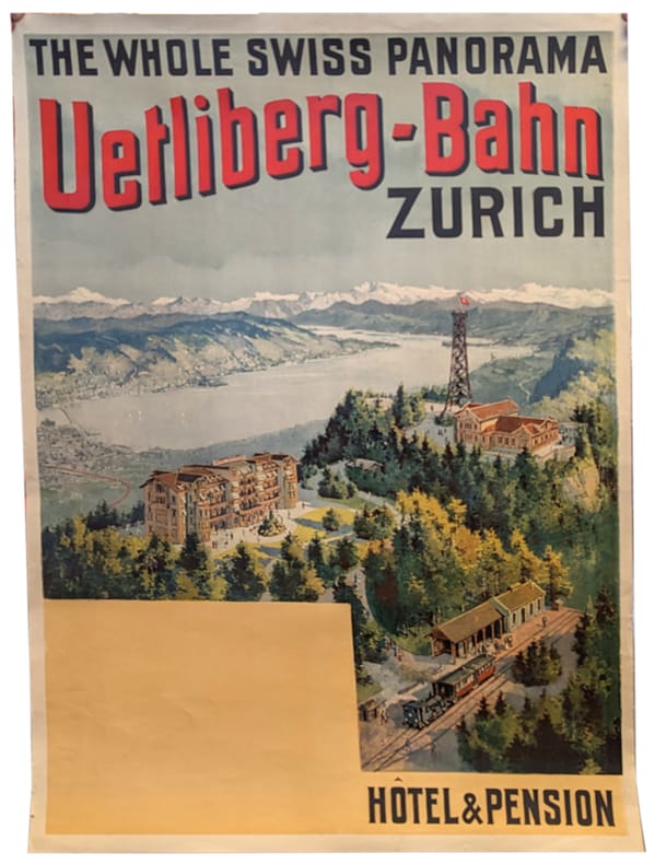
1895991DGZürich, Orell Füssli, 1895. Farb. Lithographie von 1895. Bildgrösse: 95 x 63 cm. Blattgrösse: 100 x 68 cm. + Wichtig: Für unsere Kunden in der EU erfolgt der Versand alle 14 Tage verzollt ab Deutschland / Postbank-Konto in Deutschland vorhanden +, 991DG
240483Paris, chez l'auteur [Typographie Lacrampe], Orléans, Alphonse Gatineau, 1845 grand in-4, [2] ff. n. ch., 4 pp. de prospectus, [106] ff. n. ch., texte sur deux colonnes, avec 50 vignettes culs-de-lampe et 50 vues lithographiées sur fond teinté, une carte dépliante "in fine", demi-maroquin noir, dos à nerfs orné de caissons à froid, double filet à froid sur les plats, tête dorée (reliure de la fin du XIXe).
1919816St. Louis MO: The Texas Railway Guide Company 1919. Softcover. Good. Published by The Texas Railway Guide Company of St. Louis Missouri the map measures 23" x 23" 570 x 570 mm. Staining and tears along the folds else near very good. Professionally matted and framed. WITH THE RARE BOOKLET: 8vo. 136 pp. Original self-wrappers chipped lower cover chipped with significant loss; textblock browned and brittle but still SUITABLE FOR EXHIBITION AND STUDY. VERY SCARCE AND BEAUTIFULLY FRAMED RAILROAD MAP OF TEXAS AND OKLAHOMA WITH THE RARE BOOKLET WHICH GIVES ROUTES OFFICIAL TIME TABLES AND ADVERTISEMENTS FOR HOTELS MOST OF WHICH HAVE BEEN DESTROYED. This work also includes parts of Oklahoma Colorado New Mexico and Mexico. Delineated are counties major cities and also small cities that at one time held a prominent place along certain railroads but has subsequently been bypassed by highways and have turned into ghost-towns. <br /> <br /> The scale of the map is approximately 10 miles to 1/4 in. The full title of the booklet is: "Texas and Oklahoma railway and hotel official guide: containing the official time tables of all railway lines operating in Texas and Oklahoma also useful and valuable information for the traveling public for shippers and for railway men generally. The Texas Railway Guide Company unknown
1895991DGZürich, Orell Füssli, 1895 Farb. Lithographie von 1895. Bildgrösse: 95 x 63 cm. Blattgrösse: 100 x 68 cm.
19392092902140902249Okitsugu shoin 1939. Soft Cover. Fine. Volume: 1 Okitsugu shoin paperback
191952159Piscataway NJ & Pittsburgh PA: n.p. ca. 1919-1920. Oblong folio. 13.75 x 10 in. 80 pp unpaginated on thick black paper. With 107 original photographs sized from 1.5 x 2.5 in. up to 8.5 x 11 in. with many of the photos containing neatly lettered captions below the images in white ink a few of the images tinted blue all securely mounted to the pages. Contemporary ribbed leather post-binder brass screw posts at gutter margin rounded corners yapp edges some scuffing edgewear rubbing lifting to leather at spine still a VG exemplar w/ 8 pages from the Rutgers Scarlet Letter Yearbook laid-in. This remarkable album documents the life of a Pennsylvania Westinghouse engineer working on projects for the Railroad Electrification project. The album opens with photos of camping with Rutgers’ College friends along the Ohio River the steamship Evelyn which was a 252 feet long iron steamer built for the Philadelphia & Gulf Steamship Co.; the West Penn Power Station on the Allegheny River near Pittsburgh and hijinks with fraternity brothers. The album then displays photos of the Westinghouse factories rail yards bridges and power plants near Pittsburgh. Of particular interest are the series of photographs illustrating the gas wells derricks and structures in the McKeesport PA natural gas boom which lasted for from December 1919 to the beginning of 1921 during which over $ 35 million was invested into over 500 acres of leases and then went bust when only 180 wells ended up producing gas at the time. These are followed by a series of images showing the skyline of Pittsburgh the Fort Pitt Bridge and the sternwheeler Carbon docked at the shore. These are followed by photographs showing the manufacturing of immense Westinghouse Electric Generators showing them in various stages of assembly the factory floor workers the pulley driven power system for the plant power transformers rectifiers as well as the construction of large diesel generator motors. The excellent large images which follow show electric locomotives and Westinghouse brake systems being installed on locomotives including a New Haven Baldwin-Westinghouse Class EP-1 for the Boston & Maine Railroad with the AC pantographs prominent; a Juniata-Westinghouse Class DD-1 locomotive for the Pennsylvania RR fitted with shorter DC pantographs fitted on top; two different images of the Chicago Milwaukee & St. Paul Railway Baldwin-Westinghouse Class EP-3 electric locomotives which was built and delivered to run out of Three Forks MT in December 1919 and many others. See: Electrification of Four Mountain Divisions of the C.M. & St. Paul Railway pp. 110-115; American Oil & Gas Historical Society McKeesport Gas company 2016. n.p., hardcover
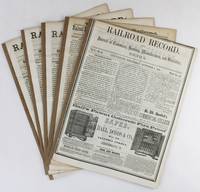
18563168Cincinnati 1856. Very good. Five issues and supplements totaling 72pp. Spines reinforced. Light tanning and dust soiling; scattered faint foxing. A lengthy extra issue of the Railroad Record with four additional eight-page supplements that together comprise a ringing endorsement from this industry periodical and its editors of the southern route through Texas and the Southwest for the American transcontinental railroad. The first two items of this extra published on October 4 1855 are by Texas Western Railroad owner and promoter Edgar Conkling who exhorts readers to examine the evidence supporting construction along the southern route and to invest in his railroad which was already sanctioned by the Texas state legislature as the text of two laws printed following his address demonstrate. Much of the issue is taken up by extracts from Secretary of War Jefferson Davis' positive report on the route through Texas and by a précis by Colonel A.B. Davis of his exhaustive survey of the proposed path through the recently completed Gadsden Purchase with a double-page map of the intended line. After several other attestations a subscription form is included at the rear for those who wish to purchase stock at $100 per share in the Texas Western Railroad Company. The additional four supplements dating from late 1855 and the first half of 1856 print more arguments in favor of the southern route including a lengthy letter from Thomas Butler King and lead articles with titles such as "What Shall Be Done for a Highway to the Pacific" and "Objections to the Construction of the Pacific Railroad reviewed." The Texas Western never built more than fifty miles of track connection Shreveport Louisiana and Marshall Texas and it was another twenty-five years before the Southern Pacific and Texas & Pacific Railroads connected near El Paso in 1881 to complete the "southern route" as it was originally conceived. unknown
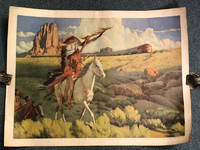
194944365N. P.: Atchison Topeka and Santa Fe Railway Company 1949. 1949. RAILROAD. 18" x 24" color print. An attractive print issued by the Atchison Topeka and Santa Fe celebrating the railroad's sleek modern trains but also highlighting the disruptive force of technology on a formerly pristine frontier. It was said of the Transcontinental Railroad completed in 1869 that it destroyed traditional conceptions of time and space by being able to move people and goods so quickly through vast distances. In this image created eighty years after the laying of the Golden Spike time and space are once again disrupted as modern train design confronts an image of three Native Americans who appear more at home in the mid-nineteenth century than the post-World War Two era. The print shows a long Super Chief passenger train cutting through a southwestern landscape with Monument Valley-type buttes rising in the background and three Native Americans in the foreground. The most prominent of the three Indians atop a trotting white horse wears a long flowing headdress and holds a spear aloft pointed toward the train. Though the chief is moving forward the train is drawn in such a way as to clearly outpace him alluding to the triumph of modern technology over the abilities of man and beast. The meaning of the chief's gesture seems a bit unclear to this viewer - it is hard to tell whether he is saluting the train or cursing it. A captivating western image. Neat expert repairs on verso to the four corners. Short repaired tear in upper margin not affecting the image repaired two-inch tear in lower left just into the image. Very good. Atchison, Topeka and Santa Fe Railway Company, 1949. unknown
190254207Chicago: Published by the Chicago Rock Island & Pacific Railway Company 1902. 1902. First edition thus. 14 1/4" x 10 1/4" printed newspaper 8 pp. triple column illustrated from photographs map of the "Great Rock Island Route System." This is Vol. XXII No. 1. Chicago January 1902. "The Western Trail is published by the Chicago Rock Island & Pacific R'Y - The Great Rock Island Route - as a quarterly and issued in the interests of the above named Company. Its endeavor will be to give its readers in considerable detail facts as to emigration securing homes and the industrial interests of the country traversed by THE GREAT ROCK ISLAND ROUTE in the states of Kansas Colorado and Texas and the Indian and Oklahoma Territories and in a general way show the industrial interests in all the states traversed by this line. Copies for a year will be mailed free." ---- Quoted from The Western Trail. Features include the Seven-Six Ranch of W. D. Wagner a few miles from Dalhart Texas that shows a ranch scene with a wonderful view of a windmill in operation. Articles about towns in Indian Territory New Mexico Colorado Oklahoma and Texas with special coverage on Addington Indian Territory Cloudcroft New Mexico Santa Rosa New Mexico and Burlington Colorado the county seat of Kit Carson County. Also some information on growing crops such as rice and broom corn. All in all an interesting newspaper for its day. This item has had detailed work by a master paper conservator as it has been deacidified a few small portions have been mended with Japanese paper and any tears or paper loss have been infilled. It has been housed in a transparent polyester "Mylar" sleeve to protect against dirt and handling. A very good and serviceable copy. Published by the Chicago, Rock Island & Pacific Railway Company, 1902. unknown
1884280East Tennessee Virginia and Georgia Railway Company O'Brien John F. General Superintendent and Flippen T. D. Auditor. <i>East Tennessee Virginia and Georgia Railway Company List No. 14. List of Stations and Names of Agents. </i>ETV&G Railway Office of the Auditor Knoxville January 31 1884. A broadside directory listing the agents by name and by town for the East Tennessee Division and branches for the Alabama division the Atlanta division and the Brunswick division and branches. A broadside sheet 34 cm x 36 cm black ink on white paper fold creases otherwise very good. The ETV&G railway became part of the Southern Railway in 1894. The ETV&G made Knoxville Tennessee a wholesaling center as it provided both passenger and freight rail service to many small communities in Appalachia. East Tennessee, Virginia and Georgia Railway Company books
4047San Francisco:: The Railroad A. H. Printing Co. . Cincinnati O. Illustrated with halftones; ii and 76 pp. 8vo limp tan full simulated leather title in gilt on front cover together with stamped presentation statement; spine expertly rebacked; very small piece lacking from top outer corner. Institutionally common scarce in trade. This is the original edition NOT a print-on-demand book.Philadelphia-born Hiram Sellers Kneedler 1859/60–1941 was a Newspaper editor and publisher who owned various newspapers in Iowa including the The Times in Cherokee and The Boone Republican and who wrote several travel books for the railroads. In 1913 he uprooted his family and drove them all in his 1913 Studebaker to California where he stayed for about 10 years doing various jobs including working on newspapers and becoming Secretary of the Chamber of Commerce for San Bernardino California. He then returned to Eldora Iowa and brought The Ledger. At some point he moved back to California and he died in Los Angeles in 1941.At the time Kneedler wrote this very little was known of this coastal area. It had been sparsely populated and its development stunted by the continuing unrest in Mexico. It was only after Texas came into the United States that serious efforts were made to populate this part of the country and extol its many advantages. [San Francisco:: The Railroad] A. H. Printing Co., ., Cincinnati, O.,. hardcover
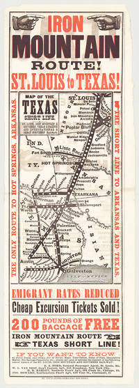
5718St. Louis: St. Louis Globe-Democrat Job Print; Woodward Tiernan & Hale Map Engr's 1878. Broadsheet with map 20.75" x 6.5" plus margins printed in black and red. Map size 11" x 5". Faded purple stamp of agent Henry H. Hannan. CONDITION: Very good upper-half of right margin rough cut. <p>A scarce and attractive promotional broadsheet with map issued by the St. Louis Iron Mountain & Southern Railway advertising special railway offers to emigrants headed to Texas.</p> <p>This broadsheet announces cheap excursion tickets free baggage up to 200 lbs. and reduced emigrant rates for departures from St. Louis on the Short Line Route which runs through Arkansas into Texas. A table of rates on the verso lists first class and emigrant rates. The Texas Short Line extends from St. Louis Missouri to Galveston and Austin and cuts diagonally across the map with various spurs along the way including intersections the Texas & Pacific R'y and the International & Great Northern R'y. Interested parties seeking assistance information on Texas maps time-tables rates of fare etc. are encouraged to call upon or address the nearest of the railroad's Agents located in Missouri Chicago New York City and Ohio whose names are provided on both recto and verso.</p> <p>The St. Louis Iron Mountain & Southern Railway began selling off land holdings in Arkansas in the mid-1870s and continued to do so into the early twentieth century. OCLC records some twenty maps published by the railroad company promoting land it owned in Arkansas issued during this time period. These lands extended from the northernmost point of the state around Little Rock to the line's southern terminus in Texarkana. The company offered various inducements for settlers deep discounts for putting money down as well as reduced freight should homesteaders wish to transport their belongings via the railway. As demonstrated by the present broadsheet the railroad also capitalized on emigration to Texas.</p> <p>OCLC records only three copies at Yale Princeton and University of Texas at Arlington.</p> St. Louis: St. Louis Globe-Democrat Job Print; Woodward, Tiernan & Hale, Map Engr's, 1878 unknown
1881List1934BCarson 1881. Single sided receipt measuring 7 ¾ x 4 ½ inches. Near fine with a small tear to bottom of page. Near Fine. A receipt issued for passage from Carson to Badie Nevada in 1881 aboard the Virginia and Truckee Railroad issued with a note that reads “Chinamen†in the remarks section. The Virginia and Truckee was originally built to service the Comstock Lode area in Nevada. Chinese who represented ten percent of Virginia City during the period referred to Nevada as “Yin Shan†which translates to “Silver Mountain.†Chinese people in Nevada held varied jobs in the state perhaps more so than in other parts of the United States with an 1870 census listing Chinese merchants miners laborers laundrymen cooks gamblers and harlots. Despite the heavy involvement of Chinese in Nevada during the period few ephemeral records surface in the trade likely due to the drops in population caused by the Chinese Exclusion Act and perhaps also due to the overall population drop when miners left the region. unknown