MELVILLE, HermanMareMagnum
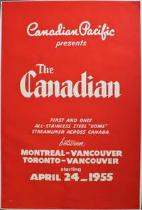
Canadian PacificBiblio.com
Chateau Frontenac Quebec
1940129895Quebec 1940. Photograph. very good. Artist Unknown. 29.25" X 35". Original B/W photograph. In large wooden frame which reads 'CP' at bottom. In very good condition with only slight yellowing due to age. Grey matting. A nice image of the Chateau. very good B/W historic photo of Chɴeau Frontenac an imposing hotel with five brick and stone wings and a central tower erected in seven stages between 1892 and 1993. It is prominently located on a cliff overlooking the St. Lawrence River within the Quec historic district. The Chɴeau Frontenac was designed by American architect Bruce Price as one of a series of "chɴeau" style hotels built for the Canadian Pacific Railway company aka CPR during the late 19th and early 20th centuries. CPR'S policy was to promote luxury tourism by appealing to wealthy travelers. The Chɴeau Frontenac opened in 1893 five years after the Banff Springs Hotel which was owned by the same company and similar in style. 1940 unknown

Aquila Books · Canada750,00 $CA≈ 509,40 €