6 262 résultats
58-0491San Francisco Calif.: Board of State Harbor Commissioners n.d. Blueline print 50 inches x 11 feet. Several small tears no missing material. From Twenty-fourth Street to Ferry Building Mission Rock to Van Ness Avenue Kansas Street. With inset map of The Presidio. No scale indicated. San Francisco, Calif.: Board of State Harbor Commissioners, [n.d.] unknown
56-0444San Francisco Calif.: Southern Pacific Company 1940 rev. 1964. Blueline print 24" x 78". From Goodwin Avenue San Fernando Road to Glendale Boulevard Brand Boulevard along Los Angeles street Los Angeles city limits railroad tracks. With Los Felix Boulevard Gardena Avenue. Includes names of businesses along and near railroad tracks. Scale 1" = 100'. With insert profile of track grade. San Francisco, Calif.: Southern Pacific Company, 1940, rev. 1964. unknown
56-0240Oakland Calif.: Southern Pacific Company 1930 revised 1960. Map. Blueline prints each 25" x 56". Station plan of Oakdale railroad property with approx. four blocks on each side along tracks from north of Stanislaus River to south of South St. Scale 1" = 100'. Oakland, Calif.: Southern Pacific Company, 1930, revised 1960. unknown
1868403801New York: Union Pacific Railroad 1868. 8vo. 40 pp. Frontispiece map additional engraved title. Original gilt-lettered cloth backed with linen. Lightly worn text slightly soiled. Provenance: S. P. Windmuller New York inkstamp on title; Arthur Elton bookplate. FIRST EDITION stated "Pamphlet Edition". Warren Heckrotte notes that "This report is celebratory - they're not finished building but there's no doubt they will be finished in a years time" and briefly discusses the " Map of the Union Pacific Railroad and its Connection" 10.5x19 cm: "The solid line from Omaha stops about at the border of Wyoming and Utah and from there to Sacramento the black line is shown with white dots. It runs north of Great Salt Lake. The point where the Union Pacific and the Central Pacific will meet is left undetermined. A branch represented by a dotted line runs to Puget Sound. This is briefly discussed and there is a separate report by Gen. Dodge on this possible branch." <br/><br/> Union Pacific Railroad hardcover books
1885403742Omaha: The Republican Printers 1885. 8vo. 64 pp. Wood-engravings in text. Original blue printed wrappers the rear wrapper with full-panel map by Matthews Northrup & Co. Buffalo. Niagara Falls ticket seller's ink advertisement stamp on front wrapper light toning at edges. FIRST EDITION. Jones Checklist 1637; Streeter sale VI:3395. <br/><br/> The Republican Printers unknown books
1878WRCAM26334Washington 1878. 235pp. Modern half morocco and marbled boards by Sangorski & Sutcliffe. Very good. Detailed correspondence relating to a controversy stemming from the rates charged by the Union Pacific for transporting the Second Infantry to the west coast. The troops were destined to suppress an Indian outbreak in Oregon. hardcover books
1914ZB583608San Francisco: Southern Pacific Company 1914. gathering in one custom binding eleven brochures promoting business residential agricultural and other opportunities in the State of California and several of its counties COMPLETE CONTENTS: California for the Settler by A. J. Wells; Glenn County California by Arthur Dunn; Sonoma County by W. Russell Cole; Fresno County by Walter B. Clausen; Sacramento County by M. B. Levick; Tullare County by M. B. Levick; Kern County by A. J. Wells; Monterey County by Arthur Dunn; Shasta County by M. E. Dillmar; Tuolumne County by Arthur Dunn; Siskiyou County by Bourdon Wilson; approximately 400 pages in all PROFUSELY ILLUSTRATED some in color original gilt stamped leather now slightly worn or discolored; overall very good. - If you are reading this this item is actually physically in our stock and ready for shipment once ordered. We are not bookjackers. Buyer is responsible for any additional duties taxes or fees required by recipient's country. Photos available upon request. San Francisco: Southern Pacific Company hardcover
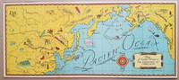
19343798<p>This delightful pictorial map focusing on the North Pacific Ocean was distributed as a premium in connection with the syndicated radio program "Air Adventures of Jimmie Allen." The program featuring Jimmie Allen as an adventurous 16-year old pilot ran from 1933 to 1937 and from 1946 to 1947 and was sponsored initially by the Skelly Oil Company.</p><p>Background on the show appears on the Radio Days Theater of the Mind Museum website http://radiodaysmuseum.org<strong>:</strong></p><p><strong>"Broadcast History:</strong> 1933 to 1937 and 1946 to 1947.</p><p>The writers of Jimmie Allen had been flying aces in World War I. They came up with the idea of a show about a boy pilot while at a party in Kansas City and used their experience as pilots to create and write the show.</p><p>The show was one of the first to capitalize on the idea of a club as a promotional tool. To join the Jimmie Allen Flying Club all a child had to do was apply at any Skelly Gas Station the initial sponsor. As a member the child received a whole host of goodies ranging from a set of wings through to a "personal" letter from Jimmie himself. An incredible 600000 club newspapers were sent out to children each week and many thousands attended the Jimmie Allen Air Races that were held in Midwest cities.</p><p>The show was first broadcast between 1933 and 1937 and then came back to the air with brand new stories after the war between 1946 and 1947. The post-war stint in no way lived up to the fascination for the show in the 1930s."</p><p>http://radiodaysmuseum.org/index.php/our-collection-1/2-old-time-radio-shows/7-juvenile/265-air-adventures-of-jimmie-allen-the</p><p>An uncommon map.</p><p><strong>References:</strong> David Rumsey Map Collection: List no. 11105.001. No examples on OCLC.</p><p><strong>Condition: </strong> Two vertical fold lines which may have been partially separated. Mounted on backing board. Very good.</p><p>ICN 7719.3</p> Skelly Oil Co.
188038887Chicago: Rand McNally & Co. n. d. ca 1880. 1880. First edition. 5 3/4" x 4" oblong color pictorial wrappers 16 pp. black & white engraved view of the "Hotel Colfax at Colfax Springs Iowa 333 miles west of Chicago and 24 miles east of Des Moines on the Chicago Rock Island & Pacific Railway." "Accommodations for three hundred and fifty guests. On the site of the famous Magnesium Chalybeate and Colfax Mineral Springs. A sanitarium for invalids and fashionable Summer Resort." Descriptive paragraphs about all the fishing grounds along the routes mostly in Illinois and Iowa with some mention of Missouri Dakota and Minnesota. Small agent's stamp at bottom of title page light evidence of a fold crease to the front cover else a near fine bright clean copy. Rand, McNally & Co., n. d. (ca 1880). unknown
1836508917Crocker and Brewster / Leavitt Lord & Co 1836. Fifth Edition. Hardcover. VERY GOOD. First Edition of what became the standard scholarly reference for New Testament Greek for the better part of the 19th century. 920pp. 4to half sheepskin leather over marbled boards marbled endpapers speckled edges. Some modest rubbing to the extremities spine a bit parched and cracking as usual with sheep tidemark to top edge of the first few pages typical age spotting otherwise a very clean sound copy. With multiple provenance inscriptions to the front matter notably for this Oregonian cataloger one 'F. W. Cathey' which is Rev. Frankly Warren Cathey b. Gresham 1863 d. Seattle 1941. Loosely tucked in between pp. 12 adn 13 is a notice of a meeting led by A. C. Scott. Both men were Methodist ministers in Oregon. Edward Robinson was one of the most prominent English-speaking Biblical Scholars in the 19th century holding professorships first at Andover-Newton and later Union Theological Seminary. 'His most important fruit . was the preparation of an independent Greek and English Lexicon of the New Testament which at once took the place of the his own translation of Wahl's Clavis. He made frequent use of his predecessors — Bruder Schleussner Wahl Bretschneider and all exegetic sources of importance; and. in the later editions particularly of the commentaries of De Wette and Meyer which he preferred on account of their great philological advantages and concise brevity without however allowing them to disturb his American orthodoxy in any important point. This extremely valuable and sterling work first appeared in 1836 and was at once welcomed as the best English lexicon of the New Test. and reprinted in three different editions in England. A new edition greatly improved and in part entirely altered appeared in 1850 and made it the first work of its kind to the present time. It is likewise an almost complete concordance and enables the student to nearly dispense with Bruder. This work is a monument of labor and industry. Its motto is 'Dies diem docet' and 'Nulla dies sine linea.'' McClintock & Strong 'Robinson was born near Southington Connecticut the-son of a Congregational minister. He was educated at Hamilton College in Clinton New York 1812-16. On a visit to Andover in 1822 Robinson fell under the spell of Moses Stuart who persuaded him to study in the seminary. In 1826 Robinson went to Europe where he studied four years primarily at Halle and Berlin. Returning to Andover he was named Professor of Biblical Literature in 1830. In 1837 Robinson was appointed to the faculty of Union Theological Seminary in New York which had been founded the year prior. William Baird History of New Testament Research II/28. Crocker and Brewster / Leavitt, Lord & Co hardcover
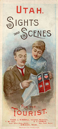
188852275Chicago: Rand McNally & Co. Printers 1888. 1888. UTAH RAILROAD. First Edition. 8vo. 21.5 x 10 cm. 8 1/2" x 4" color pictorial wrappers. 48 pp. illustrated from photographs fold-out map 'Tourist Map of Union Pacific and Connecting Lines' 20.5 x 59 cm. 8 1/4" x 23 1/2" present at the rear. The map is in nice condition and provides an excellent panorama of the Union Pacific Railway. Lines in red and run from Kansas City Atchison and Omaha to Denver and south to Gunnison or west through Cheyenne Granger and onto Portland with a spur up to Helena or west through Ogden and onto San Francisco with a spur down to Los Angeles. Blue shaded illustrations surround the lines which include a plowing scene Union Depot Salt Lake City Garfield Beach a mining scene Falls of the Yellowstone a ranching scene etc. Union Pacific produced guide for the would-be tourist of Salt Lake City including a description of the Mormons and their customs. Illustrated with nine full-page engravings from photographs by C.R. Savage. Also provided are List of Agents. Pullman Palace Car rates. Information on Salt Lake City tours Salt Lake City and the area surrounding "The Temple City" Beck's Hot Springs the Great Salt Lake Giant's Cave at Garfield Beach Echo Canon Weber Canon the Devil's Gate Ogden Ogden Canon etc. Detailed information on 9 different tours touting what the tourist might see and do. Covers lightly used light wear to fore-edges else a very good copy. Rand, McNally & Co., Printers, [1888]. unknown
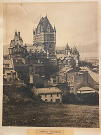
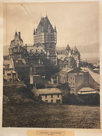
42578Artist Unknown. Quebec 1940. printed size: 68.5x 55cm 25.5"x 21.5"; frame is 90x 74cm 35.5" x 29.25" original B/W photograph some age toning as usual but a good clear image short tear on the upper right with a small puncture. . B/W historic photo of Chƒteau Frontenac an imposing hotel with five brick and stone wings and a central tower erected in seven stages between 1892 and 1993. It is prominently located on a cliff overlooking the St. Lawrence River within the Qu‚bec historic district. The Chƒteau Frontenac was designed by American architect Bruce Price as one of a series of "chƒteau" style hotels built for the Canadian Pacific Railway company during the late 19th and early 20th centuries. CPR'S policy was to promote luxury tourism by appealing to wealthy travellers. The Chƒteau Frontenac opened in 1893 five years after the Banff Springs Hotel which was owned by the same company and similar in style. Artist Unknown. Quebec, 1940 unknown
40187np. 1940. Artist Unknown. printed size: 68.5x 55cm 25.5"x 21.5"; frame is 90x 74cm 35.5" x 29.25" original B/W photograph some age toning as usual but a good clear image short tear on the upper right with a small puncture. B/W historic photo of Chteau Frontenac an imposing hotel with five brick and stone wings and a central tower erected in seven stages between 1892 and 1993. It is prominently located on a cliff overlooking the St. Lawrence River within the Qubec historic district. The Chteau Frontenac was designed by American architect Bruce Price as one of a series of "chteau" style hotels built for the Canadian Pacific Railway company during the late 19th and early 20th centuries. CPR'S policy was to promote luxury tourism by appealing to wealthy travellers. The Chteau Frontenac opened in 1893 five years after the Banff Springs Hotel which was owned by the same company and similar in style. np. 1940 unknown
1871761New York 1871. Good plus. Folding pamphlet 6 x 17 inches. Separated along one fold. A few later pencil annotations. Light wear and tanning. A scarce advertisement for bond investment in the Northern Pacific Railroad issued in 1871 during the first great construction push on the line. Although the company was founded in 1865 ground was only broken on construction in 1870 after considerable backing by Jay Cooke. This pamphlet outlines the plans for the railroad to be built from St. Paul to Portland and Seattle the prospects for passenger and freight business upon completion and the extent of the land grants afforded the railroad by the federal government. The text goes on to describe the financial instruments on offer their advantages over Treasury bonds chiefly a greater yield at 7-8% vs. 5-6% and their security against the commercial and financial assets of the railroad as well as its land grants. With a map of the proposed route on the rearmost panel. A scarce call for investment in the Northern Pacific from its early history. unknown
503718ca. 1920 by Aerograph Co. Los Angeles with blindstamp in lower left corner. Framed in a black wooden frame with white mat. Framed size: 13 1/2" x 26". F. Soft cover. paperback books
1871761New York 1871. Good plus. Folding pamphlet 6 x 17 inches. Separated along one fold. A few later pencil annotations. Light wear and tanning. A scarce advertisement for bond investment in the Northern Pacific Railroad issued in 1871 during the first great construction push on the line. Although the company was founded in 1865 ground was only broken on construction in 1870 after considerable backing by Jay Cooke. This pamphlet outlines the plans for the railroad to be built from St. Paul to Portland and Seattle the prospects for passenger and freight business upon completion and the extent of the land grants afforded the railroad by the federal government. The text goes on to describe the financial instruments on offer their advantages over Treasury bonds chiefly a greater yield at 7-8% vs. 5-6% and their security against the commercial and financial assets of the railroad as well as its land grants. With a map of the proposed route on the rearmost panel. A scarce call for investment in the Northern Pacific from its early history. unknown books
189143969San Francisco: H. S. Crocker Company 1891. Printed self-wrappers. General wear & age-toning. A few short tears along folds. Stain upper right corner. A Good copy. One long sheet oriented horizontally printed both sides in purple folded three times to form a 12-panel brochure. Illustrated with 4 wood engravings one 3-panel "Views of Pacific Grove and Vicinity"; one 2-panel and map single panel. Unfolded: 21-3/4" x 7". Folded: 7" x 3-1/2" <br/><br/>A promotional "announcement extraordinary" for a five-day program held by the YMCA at Pacific Grove from June 17 - 21 1891 featuring a program of bible study lectures e.g. "Aggressive Christian Work" "How to Teach the Bible to Young and Old" and related preaching and readings. A special train was provided for the association by the Southern Pacific Company Coast Division. Includes a large illustrated "View" and other promotional material for Pacific Grove and a map of the Southern Pacific routes to Monterey. Not found in Rocq. H. S. Crocker Company unknown books
2002DBS-9781402071430kluwer 2002. 1st. Hardcover. New. kluwer hardcover
2002DBS-9781402071430kluwer 2002. 1st. Hardcover. New. kluwer hardcover
12mo [19 x 12 cm]; [iv], xi, 123, [v, ads] pp, double page map. original blind-stamped cloth, gilt title lettering on cover, spine faded, lightly rubbed at edges, interior is near fine in very good cover. A picture of this book is available upon request by email. When nothing had been heard from Burke by 1861, four relief expeditions were organized, this one by Landsborough, this one discovering suitable land for settlement in Queensland. This work, based on Landsborough's log book, describes the expedition with accurate observations. Mueller's description of plants found in the Gulf of Carpentaria is the first such listing. Ferguson 11330. Wantrup 175. 'This London edition is quite scarce' [Wantrup, Australian Rare Books p 242].
1856120572Washington D. C. A. O. P. : Nicholson Printer 1854-1856 1856. First Edition. Hardback. Very good copy in the original gilt-blocked cloth. Professionally recased with the original spine laid back; very impressively finished. Remains particularly well-preserved overall; tight bright clean and strong. Scans and additional detail on request. ; 1 pages; Physical desc. : 1 vol. various pagings : ill ; 30 cm. Subjects; Natural history - West U. S. . Indians of North America - West U. S. . Geology - California. Washington, D. C. , A. O. P. : Nicholson, Printer [1854-1856] hardcover
Pacific Ocean Western part latitude 28"N. to 20"S. and longitude 94"E. to 160"E. including Eastern Archipelago - Magnetic variation curves are for 1930. Washington D.C., published Oct. 1931, at the Hydrographic Office, under the authority of the Secretary of the Navy. Small corrections. Folded editorially. Autore: Admiralty Charts. Luogo: Pacific Ocean Western. Anno: '900. Tecnica: incisione. Dimensioni: 777x1031 mm
1785PHO-1570Paris, Moutard, 1785. 3 volumes in-8, demi veau époque, dos à nerfs, charnières fendues, coiffes absentes, coin et coupes usés, 3ff.-viii-519pp., 2ff.-591pp., 2ff.-477pp., quelques rousseurs.
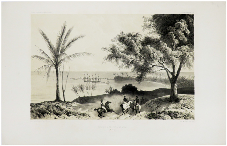
1841LBW-1308Paris, [1841-1854]. 290 x 400 mm.
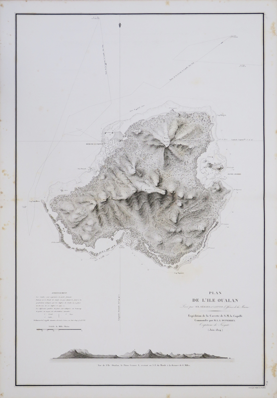
1827LBW-4444[1827]. 760 x 503 mm.