Pacifique TurabimanaBiblio.com

2 675 résultats
A9786202513616Paperback / softback. New. paperback
6202513616.Gpaperback. Good. Access codes and supplements are not guaranteed with used items. May be an ex-library book. paperback
2004Alibris.0019136Wycliffe Bible Translators. 2004. Trade paperback. Very good. No dust jacket as issued. 556 p. Wycliffe Bible Translators paperback
200051035Pacific Evenements. VG. 2000. Hardcover. Hardback in Very Good condition without dust jacket. . Oblong 4to 11" - 13" tall. 34 pages. Quick Shipping All Books Mailed in Boxes Free Tracking Provided . Pacific Evenements hardcover
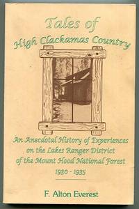
1993013864Sandy OR: St. Paul's Press 1993. First Edition. Softcover. Very Good. 196pp; Covers clean & bright previous owner's name to flyleaf text unmarked binding is tight VG condition. Anecdotal history of experiences on the Lakes Ranger District of the Mount Hood National Forest 1930 to 1935. Illustrated with photos & line drawings. St. Paul's Press paperback
2080202103705407Iwanamishoten N.A. Soft Cover. Fine. Page number: 281 5p Size: 19cm B6 Iwanamishoten paperback
20042090202117901193Iwanamishoten 2004. Soft Cover. Fine. The book is in fine condition. Iwanamishoten paperback
0077150317.Gpaperback. Good. Access codes and supplements are not guaranteed with used items. May be an ex-library book. paperback
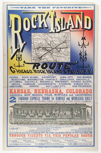
5510Chicago: Cameron Amberg & Co. Printers ca. 1880. Illustrated chromolithographic broadside with map 21.25†x 13.125†plus margins inset map measuring 4.5†x 5.875†illus. measuring 3.25†x 12.5â€. CONDITION: Very good margin chipped at upper right corner a few minor stains. <p>A rare and striking broadside issued by the Chicago Rock Island & Pacific Railway advertising the Rock Island through-express route and promoting the railroad’s numerous destinations connections and amenities.</p> <p>Featuring the eye-catching mix of typefaces and colors that characterized railroad advertising in this era this attractive broadside promotes the numerous midwestern stops and destinations accessible via the Chicago Rock Island & Pacific R’y. At this time two through-express trains for Kansas and Nebraska ran daily in connection with the Atchison Topeka & Santa Fe and Union Pacific railroads. As noted here meals were served in palace dining cars for seventy-five cents each and 150 pounds of baggage were allowed on each full ticket and seventy-five pounds on each half ticket free. The line’s various destinations included Iowa City Council Bluffs Denver Salt Lake City and San Francisco as well as “all points in Kansas Nebraska Colorado Arizona New Mexico Utah Montana and California.â€</p> <p>Showing the Rock Island R.R. in bold the inset map spans from Chicago and Lake Michigan in the east to Omaha and Council Bluffs in the west and reaches from St. Paul in the north to St. Louis and Kansas City in the south—with Lake Michigan lying in the upper-right corner. One axis of the line extends from Milwaukee and Racine Wisconsin to Leavenworth Kansas and another stretches from Chicago to Omaha. Various spurs connect to both.</p> <p>The lower section of the broadside features a marvelously detailed illustration of the interior of a palace dining car showing numerous fashionably dressed passengers seated and dining among African American waiters who are shown in the small kitchen and serving food. In the far-right end of the train men are depicted in drawing rooms—reading newspapers and smoking—and various railway operators and ticket-men appear at the ends of the car. Also included is a table of connections with various railroads that could be made in “Union depots.†Through-tickets via this route could be found on sale at all coupon offices in the U.S. and Canada. Those seeking additional information folders maps and times-tables are encouraged to contact any of the ten agents and managers of the Rock Island R.R. listed at the bottom who were based in New York Toronto Philadelphia Chicago etc.</p> <p>Established in 1847 as the Rock Island & LaSalle R.R. the company was reincorporated in 1851 as the Chicago & Rock Island R.R. Co.—its rails during this period reaching to Morris Illinois and later Ottawa. After acquiring the Mississippi & Missouri R.R. in 1866 the company was renamed Chicago Rock Island & Pacific R.R. Co. Expanding between 1873 and 1882 the company built more branch lines that reached into Iowa as well as Kansas City. In 1880 the firm was reorganized under the name Chicago Rock Island and Pacific R’y Co. and by 1883 extended nearly to the southern boundary of Kansas. After Congress granted passage across Indian Territory in 1887 the Rock Island R.R. began developing through Texas to Galveston as well as New Mexico Territory. During the 1920s the railroad enjoyed considerable success. In 1926 the company began constructing a freight line between Amarillo Texas and Liberal Kansas which was finished in 1929 and served to make accessible a country of rich grain. While the railroad industry continued fairly steadily through 1930 between 1931 and 1935 the Depression took a toll on the Rock Island R.R. and went into decline. The company ceased operation in 1980.</p> <p>OCLC records just one copy held at Yale.</p> <p>REFERENCES: “Chicago Rock Island and Pacific Railway Records†at Kansas Historical Society online.</p> Chicago: Cameron, Amberg & Co., Printers, [ca. 1880] unknown
19222080502106912589Not Available 1922. Soft Cover. Fine. The book is in fine condition. Not Available paperback
2221572<p>First edition. 7" x 9". Original stiff green wrappers stamped in white cord tie oval b/w halftone photograph of water front Tacoma. Illustrated with two fold out b/w panorama views and 17 b/w mounted halftone views on stiff grey papers. Uncommon. Very good.</p><p>Printed by Albertype Co. Brooklyn N.Y.</p> P. A. Kaufer unknown
1944Alibris.0038228Allied Geographical Section South West Pacific Area. 1944. Trade paperback. Good. ex-library label & stamps on front cover back cover has spotting chips to cover edges & top of spine stamps on title page stamp on p. 1 margin stamps & label on last blank page stamps inside back cover. 82 p. Includes: illustrations maps. . Philippine Series. Allied Geographical Section, South West Pacific Area paperback
51-0843Sacramento Division: Updated to 1961. Original blueprint dated 1961. 15 x 55 inches. Shows all the tracks and plat plans all throughout Woodland to Sugarfield with the mail line to Portland. Annotated in red by hand. Scale 1"=100'. Very useful for Phase 1 EIRs. Sacramento Division: Updated to 1961. unknown
56-0456San Francisco Calif.: Southern Pacific Company 1939. Blueline print from 24" x 55" to 30" x 55". Two maps cut and joined to detail switching limits in red pencil. Includes station point Lathrop. With two incomplete Schedules of Purchase approx 20 transfers missing information. Scale not indicated. San Francisco, Calif.: Southern Pacific Company, 1939. unknown
56-0217Southern Pacific Company 1940. Map. Blackline print. 22 x 51 inches. Green and red highlighting. Includes all switching points between Cowden and Tempe. Scale: 1 inch = 1/2 mile. Southern Pacific Company, 1940. unknown
56-0269San Francisco Calif.: Southern Pacific Company 1909 reviewed 1961. Map. Set of thirteen blueline prints. Each approximately 13 x 55 inches. With multicolor lines indicating joint use of facilities by Southern Pacific Co. and Atchinson Topeka and Santa Fe Railway Co. Scale not indicated. San Francisco, Calif.: Southern Pacific Company, 1909, reviewed 1961. unknown
58-0500San Francisco Calif.: Southern Pacific Company n.d. Blueline print 36 inches x 42 inches. From Portola Avenue to Giant Sobrante Avenue. Includes Richmond Belt San Pablo Bridge Giant Harbor Channel Inner Harbor Basin station points Stege and Richmond. Scale 1 inch = 1000 feet. San Francisco, Calif.: Southern Pacific Company, [n.d.] unknown
58-0495San Francisco Calif.: Southern Pacific Company 1949. Blueline print 26 inches x 67 inches. From Millbrae to Yerba Buena Island Hunter's Point to Daly City. With index to industry approx. 850 entries listed both Alphabetically and by numerical location on map. Scale approx 1 inch = 1200 feet. San Francisco, Calif.: Southern Pacific Company, 1949. unknown
58-0480San Francisco Calif.: Southern Pacific Company 1945. Blueline print 19 to 24 inches x 78 inches. Two maps joined with red pencil indicating switching limits. From Clear Creek at Girvan to beyond City of Redding. With City of Redding station point Girvan discontinued Standard Oil station. With Schedule of Property listing approx 30 transfers 1872 - 1945. Scale 1 inch = 400 feet. San Francisco, Calif.: Southern Pacific Company, 1945. unknown
56-0457San Francisco Calif.: Southern Pacific Company 1933. Blueline print 24" x 56". From approx 3 miles southwest of station point Lockeford to 1 1/2 mile northeast of station point. Includes Small Farms Improvement Tract. With Schedule of Property listing 18 transfers 1882 - 1933. Scale 1" = 400'. With inset showing details of property scale 1" = 100'. San Francisco, Calif.: Southern Pacific Company, 1933. unknown
56-0374San Francisco Calif.: Southern Pacific Company 1945. Notes added 1961. Map. Blueline print 18" x 65" with red pencil indicating switching limits. Two maps joined together to indicate switching zones. From Wellsdale to Cantonment. Includes US Army Camp Adair. With Schedule of Property listing approx 15 transfers 1879-1945. Scale not indicated. San Francisco, Calif.: Southern Pacific Company, 1945. Notes added 1961. unknown
58-0494San Francisco Calif.: Southern Pacific Company 1936. Blueline print switching zones map14 inches x 32 inches switching zones indicated in red purple green yellow brown with red pencil. File cover indicating "Switiching Limits of San Francisco" dated 1962. Three pages of Switching Charges effective 1960 attached. San Francisco, Calif.: Southern Pacific Company, 1936. unknown
58-0479San Francisco Calif.: Southern Pacific Company 1959. Blueline print 24 inches x 9 feet. Three maps joined irregularly with red pencil indicating switching limits. From beyond Sacramento and Clear Creek to beyond City of Redding. With City of Redding station point Girvan. With Schedule of Property listing approx 50 transfers 1872 - 1959. Scale 1 inch = 400 feet. San Francisco, Calif.: Southern Pacific Company, 1959. unknown
A9789211014808Paperback / softback. New. Examining financial strategies across Asia-Pacific the report addresses climate action and sustainable growth by mobilizing public and private capital. It outlines eight strategic principles to guide policymakers regulators and investors in fostering regional cooperation toward a credible net-zero trajectory. paperback
1528203623.Gpaperback. Good. Access codes and supplements are not guaranteed with used items. May be an ex-library book. paperback