5 782 résultats
Second Bonaventure and Abraham Elzevier edition, more beautiful and more correct than their first release of the same year. Modern green boards, 64mo (2x3, miniature), 422+ [6] pages. In Latin. Illustrated title page which includes a nice title-frontispiece on copper showing, among others, a birds eye view of Constantinople from the harbor. Willems, 367.The author had been commissioned by Francois I to the Sultan Suleiman the Magnificent. He left a testimony of the greatest importance describing Constantinople at the time of the great architectural upheavals. Thanks to him, one can locate most of the destroyed ancient buildings. The Elzevirs were a celebrated family of Dutch booksellers, publishers, and printers of the 17th and early 18th centuries. The duodecimo series of Elzevirs became very famous and very desirable among bibliophiles, who sought to obtain the tallest and freshest copies of these tiny books .The family ceased printing in 1712 Bonaventura Elzevir (15831652)...began business as a publisher in 1608, and in 1626 took into partnership Abraham Elzevir, his nephew .Abraham died on 14 August 1652, and Bonaventura about a month afterwards. The fame of the Elzevir editions rests chiefly on the works issued by the firm of Bonaventura and Abraham .their small editions in 12mo, 16mo and 24mo, for elegance of design, neatness, clearness and regularity of type, and beauty of paper, cannot be surpassed .Between 1626 and 1649, Bonaventure and Abraham Elzevir published a bestselling series titled the Respublicae (commonly known as the Republics or Petites Républiques), the ancestor of the modern travel guide. Each of the thirty-five volumes in the series gave information on the geography, inhabitants, economy, and history of a country in Europe, Asia, Africa, or the Near East (Wikipedia). Subjects: Antiquities. Travel. Istanbul (Turkey) -- Description and travel. OCLC: 35259302. Faint blind stamps and paper repair on blank end pages. Nice margins, good attractive paper and internal binding.Very Good Condition. (AC-22-1)
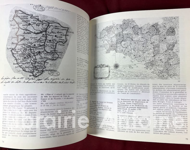
19874095Paris Archives de France 1987 In-8 (h. 24 cm.) 192 pp. couverture souple. Illustrations en noir et en couleurs.
ORD-16692Tiré de l'Atlas des Ports étrangers. Paris. Imprimerie Nationale. 1886. Grand plan de 74 x 33 cm plié en 4 volets, gravé par A. Simon, publié par le Ministère des Travaux Publics. Impression en noir et bleu. Bords de feuille lgt poussiéreux sinon bon état.
ORD-16700Tiré de l'Atlas des Ports étrangers. Paris. Imprimerie Nationale. 1886. Grand plan de 49 x 33 cm plié en 2 volets, gravé par A. Simon, publié par le Ministère des Travaux Publics. Impression en noir et bleu. Bords de feuille lgt poussiéreux sinon bon état.
In-12, pleine basane de l'époque, dos à nerfs (rel. frottée, manque de cuir en pied), (10) f., 530 p., (13) f., grande carte historique de l'Europe dépliante, portrait des rois de France dans des médaillons sur bois. Nouvelle édition considérablement augmentée. La grande carte d'Europe est gravée par P. Ganière. Portraits des rois de France dans des médaillons sur bois en tête de chaque notice. (G. Kaucher, ‘Les Jombert’, n°403). Ex-libris anciens manuscrits.
Very Good Turkish, Ottoman (1500-1928) Original color map on cloth. A little foxing on cloth. Very good. Folded. Oblong atlas folio. (50 x 67 cm). In Ottoman script. Scale: 1/300.000. Map of Ottoman Kayseri printed in its period. No publisher and map-maker. Physical geography of Kayseri city and its around. It shows Kayseri, Sultan Sazligi, mountains and hills, Malatya borders, etc.
Very Good Turkish, Ottoman (1500-1928) Original color map on cloth. Oblong eephant folio. (64 x 573 cm). Toponyms in Ottoman script. [MAP of BALKANS] Filibe [Plovdiv]. A very detailed map. Shows Plovdiv and mountains, rivers around it. Extremely rare.
Very Good French Original color map on cloth. Oblong folio. (42 x 53 cm). In Ottoman script. [MAP] Büyükada, Maltepe ve Adalar. [Feuille of Sedef Island and South of Prinkipo, Marmara Sea]. 6th sheet of set.
Very Good French Original color map on cloth. Oblong large folio. (49 x 58 cm). In Ottoman script. [MAP] Kocaeli-Izmit Körfezi. Gökbüze, Derince, Dilburnu, Hersek Gölü. [Izmit Bay, Dilburnu, Gökbüke, Derince, Marmara Sea]. Scale: 1/50.000.
Very Good Turkish, Ottoman (1500-1928) Original color map. Folded. Oblong atlas folio. (50 x 60 cm). In Ottoman script. [MAP of EAST ANATOLIA] Malatya - Divrigi, Mancinik, Adiyaman, Harput. Shows Malatya, Adiyaman and Kharpout region; Firat River (Euphrates), Yazi Düzü, Erguvan etc. Scale: 1/200.000. This is one the serie of the Bonn projection maps which are the first map series in modern techniques in Turkey and the Ottoman Empire. In order to produce these maps covering Turkish territory, Reconnaissance Branch was incorporated into The Mapping Commission. The maps were produced in the datum based on the latitude and longitude of Ayasofya Mosque in equal area Bonn Projection. The field works for the 123 sheets covering the country were conducted by 76 staff. The production was completed in 18 years starting from east west. Field works continued without stopping except in years 1914 and 1920. This map series called also reconnaissance maps contributed a lot to producing 1:25.000 scale maps. Hegira: 1332 = Gregorian: 1916. Not description on map-maker. According to Türkezer & Çobanoglu: History of Mapping in Turkey-1:200.000 Scale Maps, cartographer of this map is Kambay, Cemal.
18082401Paris, F. Schoel, 1808. 2 volumes, complet. In-8 – 13 x 21 cm. Reliure légèrement postérieure en demi-vélin à coins, dos lisses ornés, pièce de titre en maroquin rouge, doubles filets dorés sur les plats, tranches vertes. 3ff., II, 4pp., 1f., 404pp., 2ff.; 2ff., 372pp., 1f. Edition originale et unique édition. Exemplaire bien complet de ses 20 planches hors texte dont 12 dépliantes, 7 doubles, 1 en couleurs. Elles montrent diverses techniques de gravures et des filigranes. Quérard, IV, 205. Brunet, 9506. Monglond, La France Révolutionnaire et Impériale, VII, 1249-1251. Cet « ouvrage extrêmement recommandable et abondant en documents de toutes sortes » (Bourcard) est suivi de « Recherches sur l'origine du papier de coton et de lin, sur la calligraphie, sur les miniatures, sur les filigranes des papiers ». Il contient également des « Recherches sur l'origine des registres, des signatures, des réclames et des chiffres de page » par G.-G. Magné de Marolles, un « Mémoire sur l'origine des signatures et des chiffres dans l'art typographique » par M. C. de La Serna Santander et une « Notice sur les éditions stéréotypes » par F. Schoell. Ouvrage original et même pionnier, car il aborde des domaines majeurs de l’histoire de la typographie jusqu’alors relativement délaissés. Seule édition de ce précieux traité, qui inspirera de nombreuses recherches tout au long du siècle d’or de la bibliophilie.Hendrik Jansen, né à La Haye, s'installe à Paris dès 1770 où il travaille comme traducteur avant d'ouvrir une librairie et une imprimerie en 1791. En 1806 il devient bibliothécaire de Talleyrand, auquel il dédie cet essai.
9818English; circa 1790. 8vo 6 pp. Two bifoliums sewn together. On laid paper with Britannia watermark. Text clear and complete. Neatly written out at approximately 38 lines to the page. On aged paper with slight damage to the first bifolium the leaves of which are detaching at the spine. Some of the items have been lightly scored through in pencil but are still legible. The inclusion of such items as '149 Blank Silk Paper for copying Maps' would appear to indicate that the document is an inventory for probate of a cartographer's stock. Last two entries read '165 Blank Sheets of Paper for copying Maps. A Bond relating to the Honble. Thomas Howe. Prints to copy from. Several Plans of the River and Sound of Dawfoskee in South Carolina survey'd by Captn. Gascoigne. 166 Draught of Falklands Islands. Map of the Province of New York. La Cours de la Meuse. The Circle of the Inferior Rhine. Plans of Port Royal in South Carolina. Les Duchés de Lorraine & De Bar. Plans of the River & Sound of Dawfoskee in South Carolina.' The first two entries list items by John Hamilton Moore a Scottish cartographer who according to his obituary in the Gentleman's Magazine was 'late teacher of Navigation on Tower-Hill author of Moore's Navigation Seaman's Daily Assistant the Monitor &c.' English; circa 1790. unknown
Very Good German Original color map on cloth. A little foxing on cloth. Very good. Folded. Oblong folio. (45 x 51 cm). In German. Shows N. Enyed, Zalathna, Mediasch, Hermannstadt, Hatszeg, Petroseni, Ôzt River, etc. Scale: 1/300,000. Sibiu (Sibiiu - Hermannstadt - Nagyszeben) is a city in Romanian Transylvania. The city straddles the Cibin River, a tributary of the river Olt. The first official record referring to the Sibiu area comes from 1191 when Pope Celestine III confirmed the existence of the free prepositure of the German settlers in Transylvania, the prepositure having its headquarters in Sibiu, named Cibinium at that time. In the 14th century, it was already an important trade center. As of the year 1376, the craftsmen were divided into 19 guilds. Sibiu became the most important ethnic German city among the seven cities that gave Transylvania its German name Siebenbürgen (literally "Seven Citadels"). It was home to the Universitas Saxorum (Community of the Saxons), a network of pedagogues, ministers, intellectuals, city officials, and councilmen of the German community forging an ordered legal corpus and political system in Transylvania since the 1400s. During the 18th and 19th centuries, the city became the second -and then the first most important center of Transylvanian Romanian ethnics. The first Romanian-owned bank had its headquarters here (The Albina Bank), as did the ASTRA (Transylvanian Association for Romanian Literature and Romanian's People Culture). After the Romanian Orthodox Church was granted status in the Habsburg Empire from the 1860s onwards, Sibiu became the Metropolitan seat, and the city is still regarded as the third-most important center of the Romanian Orthodox Church. Between the Hungarian Revolution of 1848 and 1867 (the year of the Ausgleich), Sibiu was the meeting-place of the Transylvanian Diet, which had taken its most representative form after the Empire agreed to extend voting rights in the region (Source: Wikipedia). A sheet of the collection of 'The general map of Central Europe'. appeared in the years between 1873-1876 with the work of Joseph Ritter von Scheda, (1815-1888) who was a general, geographer, and cartographer.
200054505Santiago de Compostela, Universidade, 2000. 4°. Mit zahlr. farb. Abbildungen. 280 S., 1 Bl., OPpbd. m. illustr. OUmschlag.
ORD-5757au 1/80000 levée par les Officiers du Corps d'Etat-Major et publiée par le Dépôt de la Guerre en 1856. Imp. Lith. Lemercier, report sur pierre. Gde carte en 4 pièces collées sur toile (580x845mm)
ORD-5762avec Notice historique, levé, dessiné et rédigé par GOY, Capitaine au 45°de Ligne, dédié au Comte de Paris. Gravé sur pierre par Schwaerzlé, imprimé chez Jules Rigo. Publié par Thez à Rochefort. 1844. Grand plan de 1145 x 845 mm, contrecollé sur papier, flanqué de 4 vues gravées par Boullet et du cartouche contenant les légendes. Traces de pliures sinon bon état.
ORD-5928Hachette. fin XIX°. Carte de 34x47cm repliée sous cartonnage vert de l'éditeur, format de poche.
179011074Paris, Dezauche, 1790. 4 cartes géographiques horizontales, réhaussées en couleurs, de 157 x 60 cm., entoilées sur un beau tissu saumon, au format plié de 13 x 22 cm., chacune avec l'étiquette de Goujon (marchand de géographie ancienne et moderne) contrecollée, languette de vélin portant le nom des cartes. Emboîtage en bois imitant la forme de 2 livres in-4, demi-veau blond, dos lisses ornés de décors dorés, étiquettes de titre ("Hollande") et tomaison vertes avec décors dorés, plats saumon encadrés de roulettes dorées avec "Bibliothèque V. Perdonet" en lettres dorées au premier plat. Quelques frottements à l'emboîtage, les cartes étant quant à elles en parfaite condition.
11075Paris, Dezauche, 4 cartes géographiques horizontales, réhaussées en couleurs, de 165 x 48.5 cm., entoilées sur un beau tissu saumon, au format plié de 14 x 21.5 cm., chacune avec l'étiquette de Goujon (marchand de géographie ancienne et moderne) contrecollée, languette de vélin portant le nom des cartes. Emboîtage en bois imitant la forme d'un volume in-4, demi-veau blond, dos lisse orné de décors dorés, étiquettes de titre ("Zélande") et tomaison noires avec décors dorés, plats saumon encadrés de roulettes dorées avec "Bibliothèque V. Perdonet" en lettres dorées au premier plat. Quelques frottements à l'emboîtage, les cartes étant quant à elles en parfaite condition.
Carte dépliante lithographique en couleurs (85 x 67 cm) Très bon état. [ARCH]
ORD-16771Tiré de l'Atlas des Ports étrangers. Paris. Imprimerie Nationale. 1886. Grand plan de 74 x 33 cm plié en 4 volets, gravé par A. Simon, publié par le Ministère des Travaux Publics. Impression en noir et bleu. Bords de feuille lgt poussiéreux sinon bon état.
ORD-16773Tiré de l'Atlas des Ports étrangers. Paris. Imprimerie Nationale. 1886. Grand plan de 53 x 33 cm plié en 3 volets, gravé par A. Simon, publié par le Ministère des Travaux Publics. Impression en noir et bleu. Bords de feuille lgt poussiéreux sinon bon état.
ORD-16776Tiré de l'Atlas des Ports étrangers. Paris. Imprimerie Nationale. 1886. Grand plan de 74 x 33 cm plié en 4 volets, gravé par A. Simon, publié par le Ministère des Travaux Publics. Impression en noir et bleu. Bords de feuille lgt poussiéreux sinon bon état.
34837In-12, plein veau marbré de l'époque, dos lisse orné de compartiments cloisonnés et fleuronnés, pièce de titre de maroquin bordeaux, tranches rouges, xii, 356 p. et (4) p. d'approbation et privilège, 2 très grands plans dépliants hors texte. Paris, C.A. Jombert, 1756.
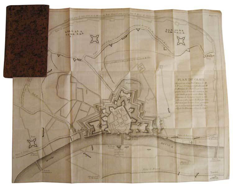
In-12, plein veau marbré de l'époque, dos lisse orné de compartiments cloisonnés et fleuronnés, pièce de titre de maroquin bordeaux, tranches rouges, xii, 356 p. et (4) p. d'approbation et privilège, 2 très grands plans dépliants hors texte. Première édition collective illustrée de 2 très grands plans dépliants des villes de Grave et Mayence. En juillet 1674, les Hollandais mirent le siège pendant 93 jours devant Grave dans le Brabant-Septentrional, ville occupée par les français depuis 1672. Les pertes furent considérables des deux côtés. Fin octobre, le gouverneur de la place, le marquis de Chamilly, reçut l’ordre du roi de se rendre. Ce qui restait de la garnison défila devant l’armée hollandaise qui lui rendit les honneurs et le Prince Guillaume III d'Orange récupéra la ville le 28 octobre 1674. Le siège de Mayence se déroula du 1er juin au 8 septembre 1689, pendant la guerre de la Ligue d’Augsbourg. "Récit méthodique, composé par un témoin oculaire. Exposé par ordre chronologique. Correct, froid, très détaillé et très utile" (Sources de l’Histoire de France, n° 3973). Petite étiquette imprimée à l’époque de la librairie Cellot et Jombert, "Rue Dauphine, la seconde porte cochère à droite par le Pont-Neuf, au fond de la cour". Bel exemplaire, frais, très bien relié à l’époque.