692 508 résultats
44 albumen prints and 1 picture postcard. Various sizes (58 x 85 mm - 160 x 212 mm). Inserted in protective sleeves. Stored in a black calf binder. A substantial collection of rare images of Kings Faisal I and Faisal II of Iraq, showing the monarchs greeting international delegations, attending banquets and meetings, or inspecting the troops. Includes a photograph of the Arab delegation in the Blue House Hotel during a finance conference in 1944. - In addition, the set includes a portrait of Iraqi president Abdul Salam Arif. The postcard shows a group picture including the Ottoman Pasha and Mohamed Al Sheheri around 1925, after the Arab Revolt. - Finally, three small photographs of a group of white-dressed girls dancing also form part of this collection. - Many photos with stamps of the corresponding studio on verso; the bulk prepared by Elias Jamoua, several other photos produced by A. Abbosh and Arshak in Baghdad. - Some pictures with Arabic or English captions. Not traced in the Keystone or Hulton/Getty press photo archives. Very well preserved.
Original watercolour drawing over ink. 267 x 196 mm. On thick oriental wove paper. Original ink drawing of the armillary sphere (Zâtü'l-Kürsü, "instrument on pedestal") published in 1732 in the famous universal Islamic geography "Kitab-i Cihânnümâ" of Katib Chelebi (1609-57). The present watercolour by Ahmed Al-Qirimi, who also contributed the maps to Ibrahim Müteferrika's famous publication of Katip's atlas, probably served as the direct model for the engraved plate. Müteferrika, a Hungarian convert to Islam, completed Katip's unfinished work, which had hitherto circulated in manuscripts only. He had the maps specially drawn and cut for it, and printed it at his own press, the first printshop in Turkey. - While extremely close in design and size to the present drawing, the published plate differs from it in several respects, lacking numerous details as well as - most conspicuously - the four additional instruments which here decorate the corners; on the other hand, the print shows the pedestal placed upon an additional short plinth not seen in the sketch. - Evenly browned and with a few small edge flaws, but well preserved.
Latin ms. on vellum. 372 x 295 mm. Secretarial letter of safe conduct for the merchant and diplomat Anselm Adornes (1424-83) for a Burgundian embassy to Persia, issued in the name of Casimir IV Jagiellon, King of Poland. - From March to June 1474, Adornes, Lord of Cortachy, led an embassy in the name of Charles the Bold to the Shah of Persia Uzun Hassan (1423-78), whom the Duke of Burgundy sought to persuade to engage in a new military expedition against the Ottomans, following a campaign in the previous year which had ended in Uzun Hassan's defeat by Mehmed II. Adornes was chosen for this mission due to his knowledge of Muslim territories; he had made a pilgrimage to the Holy Sepulchre in Jerusalem in 1470/71 (the account of his journey written by his son Jan is still preserved). - One of the most illustrious members of the Adornes-Adorno family, of Genoese origin, and a wealthy patron, Anselm was closely involved in international trade (mainly in alum and cloth from Tournai and England). He maintained commercial relations with Genoa as well as Spain and played an important role in Burgundian diplomacy. - Seal missing; a large tear touching the last lines of the text. Folded. Cf. Nationaal biografisch woordenboek XII, 2/25. C. van Hoorebeeck, Livres et lectures des fonctionnaires bourguignons (Turnhout, 2014), passim.
180 x 305 mm. 48 chromogenic and 49 silver gelatin photographs, ranging from 80 x 80 mm to 19 x 126 mm, and housed in photo sleeves. Contemporary spiral-bound illustrated boards. An album of 97 vintage photographs and photographic postcards showing the construction works for the Kuwait oil industry, likely at the famous Burgan and Al Bahrah oil fields and refineries. During the early decades of oil production, the Kuwait Oil Company worked to develop the flowering industry, sometimes partnered with British oil company BP. Several photographs were likely taken by European engineers who moved to Kuwait to work in the oil industry; some of the early silver gelatin photographs were printed in Germany, while several other silver gelatin prints have the stamp of the Armenian-Syrian photographer Vartan Derounian (1888-1954) and/or the stamp K.E.W., that is of the Kuwait Engineering Works Ltd. Since oil was discovered in Kuwait at Burgan oil field in 1938, the petroleum industry has become the largest in the country, responsible for roughly half of Kuwait's GDP. This series of photographs, beginning in roughly the 1950s and with the latest photograph dated 1978, illustrates three decades of infrastructure development and expansion in the industry, including numerous detailed scenes of tanks, wells, and pipelines. - A few light signs of wear, altogether very well preserved.
Varying sizes (ca. 60 x 55 mm to 20 x 14 mm). Engraved bronze. Set within a modern frame (36,4 x 30,4 cm). Rare document of the Roman presence on the Arabian Peninsula, comprising 15 fragments in good condition. The diploma was issued for an equestrian named Bithus of the ala praetoria singularium, an auxiliary cavalry unit stationed in Syria, under the command of Aulus Furius Saturninus during the reign of Emperor Domitian (81-96). It can be dated with a high degree of certainty, as Aulus Furius Saturninus is only traceable to military diplomas issued as part of an imperial military constitution for 5 alae and 2 cohorts in Syria from 8 November 88. The name Bithus is probably of Thracian origin. - The ala praetoria singularium was one of 14 alae and 33 cohorts stationed in the province of Syria between 88 and 157. These troops built and defended the almost 1500 kilometre Limes Arabicus, a system of streets, watchtowers, and forts that had its origin in the Roman conquest of Syria in 64 BCE and reached its greatest extent in the second century. Palmyra and Damascus were among the fortified cities along the Limes Arabicus. - From the German collection of Peter Weiß, acquired before 1980. Published: P. Holder, Roman Military Diplomas V (London: University of London, Institute of Classical Studies, 2006), p. 771 f., no. 330. P. Weiß, Neue Militärdiplome, in: Zeitschrift für Papyrologie und Epigraphik 117 (1997), pp. 229-231.
Folio. 50 pp. Dated 16 Oct. 1844 to 21 April 1845. Bound in loose covers with a handwritten title "Log of the proceedings of HMS 'Agincourt' - H. W. Bruce Esqr., Captain. Bearing the Flag of Rear Adml. Sir Th. Cochrane RN, From the 16th October 1844 to the 8th March 1845 [sic], Rept. by - Elphinstone D. D. Aplin, Mate". The log contains detailed daily entries tracking the ship's travels to Asia, including Chusan, Hong Kong, and Singapore. Each day's entry provides the ship's bearings, speed, wind direction, and distance travelled, and contains remarks on the ship's maneuvers, signals, and activities. In addition to the necessary constant maintenance plus sail and course correction, ship activities included cutlass drill and mustering of the crew for general review, church services, and leisure time ashore for recreation and amusement. Occasional punishments are listed, with entries on 13 March 1845, "Punished Ed Bhilsly with 48 lashes for insolence", and 20 March, "Punished Jno. Elliott with 36 lashes for Insubordination". - Expected wear to the covers (including tears, toning, and small areas of paper loss); interior pages are in fine condition. The journalist, Elphinstone D'Oyley D'Auvergne D. Aplin, joined the Royal Navy in 1838 and was appointed as acting lieutenant on the HMS Agincourt on 2 April 1845, while making the last entries in this log. He rose to command the HMS Hecla in the mid-to-late 1850s, and in 1861 commanded the HMS Centaur in China during the Taiping Rebellion.
Folio. 19 ff. of thick dark cardboard. With 7 pen-and-ink drawings and 7 photographs. Contemporary brown calf with brass corner fittings. All edges gilt. The splendid album celebrating the 25th anniversary of the women's shelter and retirement home, which was established in 1883 and rebuilt in 1906/07 after plans by Karl Holzer. It begins with a portrait photograph of Archduchess Marie Valerie, who functioned as the institution's patron in 1903. The portrait is followed by a history of the building on ff. 2-5. Seven pen-and-ink drawings on ff. 6-12 show an exterior view, the hall, parlour with hall, dining hall, bedroom, kitchen and garden front, while ff. 13-19 show seven photographs of the main front, dining hall, parlour, hall with staircase, kitchen, chancery and the old building existing until 1906/07. - The album describes the history of the women's home, tracing its existence back to 1881, when several Viennese women joined to found an association aiming at providing single elderly, poor but educated women with affordable flats and meals in a Viennese home for women. - Located near Schönbrunn, the shelter in the Frauenheimgasse today is operated by the Catholic relief and social service organisation Caritas. - Lacks the clasp. Binding slightly rubbed and a little cracked near the upper joint. Flyleaves somewhat waterstained, cardboard leaves rubbed at the edges.
33 original black-and-white NASA photographs (gelatin silver prints), ca. 255 x 203 mm each, with extensive official captions and NASA logo printed on the back in purple ink. Stored within black cardboard binder, photographs in individual transparent sleeves. A collection of original gelatin silver prints showing the surface of the planet Mars, taken by the American robotic space probes Mariner 6, 7, and 9: five photographs taken by Mariner 6 and seven taken by Mariner 7 (1969); the remaining 21 taken by Mariner 9 in 1971-72. All are extensively annotated on the reverse with NASA's printed official photo captions. - Mariner 6 and 7 flew over Mars' equator and south polar regions, analysing the atmosphere and the surface with remote sensors and relaying to Earth hundreds of grayscale pictures. The mission goals were to study the surface and atmosphere of Mars in close flybys, so as to establish the basis for future investigations and to demonstrate and develop technologies required for future Mars missions. Two years later, NASA launched Mariner 8 and 9 - the former crashing into the Atlantic immediately, leaving the single surviving orbiter to perform a mission designed for two. Upon its arrival, NASA scientists were further dismayed to find the planet obscured by thick dust storms. Nevertheless, the mission turned out a complete success: after the dust had settled, the probe managed to send back excellent pictures of the surface. After 349 days in orbit, Mariner 9 had transmitted no fewer than 7329 images, covering 85% of Mars' surface. The images revealed river beds, craters, massive extinct volcanoes (such as Olympus Mons, the largest known volcano in the Solar System), canyons, evidence of wind and water erosion and deposition, weather fronts, and fogs. Mars' moons, Phobos and Deimos, were also photographed. The findings from the mission underpinned the later Viking program. - The exploration of Mars continues: the summer 2020 launch window saw the United Arab Emirates send an orbiter on the Al Amal (Hope) Mars Mission. It arrived in February 2021 to study the Martian atmosphere and weather.
193 Fouragezettel mit den Unterschriften französischer Offiziere. Gruppenweise oder einzeln abgelegt in zeitgenöss. vorgedruckten Archivumschlägen der französischen Armee, diese ihrerseits in 4 Sammlungsmappen um 1900. Beiliegend 1 maschinschriftlicher "Katalog des Konvoluts von Formularen der Régie des Fourrages, Place de Leipzig, Okt. 1806-März 1807". 100 SS. Sämtlich in Halbleinen gebunden und mit handschriftl. Deckeltitel, jeweils Kl.-Folio (ca. 23:28 cm). Hübsche, umfassende Sammlung von Fouragequittungen aus dem während des Vierten Koalitionskriegs besetzten Leipzig mit den Unterschriften bedeutender napoleonischer (teils kommandierender) Offiziere, darunter Jacques Allain (1773-1851), Louis Hullin de Boischevalier (1770-1809), Louis-Jacques de Coehorn (1771-1813), Joseph Goll (1771-1850), Jean-Michel Haudebault (1766-1837), Louis-Joseph Maupoint (1766-1850), Simon Prévost de Vernois (1778-1859), Jean-Gaspard René (1769-1808), Auguste Talhouet (1788-1842), Jean-Marie de Varlet (1775-1857) und Charles-Louis Vimeux (1787-1859). - Obwohl das Rückgrat auch des napoleonischen Heers weiterhin die billigere und wendigere Infanterie bildete und Napoleons Hauptaugenmerk als Feldherr stets der Artillerie galt, waren Pferde unerlässlich nicht nur als Kavallerieeinheiten im Kampf, sondern auch für die Heereslogistik, gerade für den Transport der schweren Geschütze. Allerdings waren Pferde zu Beginn des 18. Jahrhunderts für die erschöpfte französische Staatskasse ein besonders rares Gut: Die meisten Gestüte lagen außerhalb der Landesgrenzen, und die mit der Flucht des Adels entstandenen Lücken unter der Kavallerieoffizieren hatten sich nur allmählich aus den nachrückenden Rängen sowie durch Remigranten füllen lassen. Umso peinlicher war die Buchführung über alle Ausgaben für die fast unvertretbar kostspieligen Tiere, insbesondere über die unablässige Fouragierung. Die vorliegende Sammlung von Quittungen, gemeinsam abgelegt in von der Armee vorgedruckten Umschlägen, zeugt von der genauen Organisation des Verpflegungsvorgangs. Als nach der Schlacht bei Jena und Auerstedt am 14. Oktober 1806 Preußen und Sachsen von Frankreich besetzt wurden, zog Marschall Davoust am 18. Oktober in Leipzig ein; schon die erste hier überlieferte Fouragequittung datiert vom 19. Oktober. Die Quittungen sind von Sekretärshand - teils auf Vordrucken - geschrieben und von den verschiedenen Offizieren, Unteroffizieren, Soldaten und Militärbeamten unterschrieben und von Sekretären gegengezeichnet. Zumeist tadellos erhalten in den originalen Archivumschlägen, gegenüber deren zeitgenössischen Aufschriften nur wenige Blätter fehlen. Anfang des 20. Jahrhunderts in vier Mappen abgelegt und in einem maschinschriftlichen Katalog erfasst, die Schreiber biographisch erschlossen. Gegenüber dem um 1928 vorliegenden Bestand fehlt heute eine "kleine Mappe", hauptsächlich Quittungen von Bory, Guyardet, Siry, Souplet, Thevenet und Varlet umfassend (davon noch die Formularumschläge mit 2 Quittungen vorhanden). - Provenienz: Der ungenannte Bestandsbildner (nach seinem selbst angelegten Katalog wohnhaft in Zehlendorf und anscheinend aus in Appelwerder/Westpreußen begüterter Offiziersfamilie, noch 1918 an der Salonikifront; sein nicht identifiziertes Adelswappen auf S. 1 gestempelt) hatte die zwischenzeitlich verstreute Sammlung hauptsächlich zwischen 1918 und 1928 (mit zwei Ergänzungen bis 1938) aus Angeboten verschiedener Händler wieder zusammengetragen, darunter R. Hönisch und W. Hiersemann in Leipzig, H. Burmeister und J. A. Stargardt in Berlin. Erworben aus Privatbesitz.
Oblong 4to (287 x 195 mm). 23 leaves with 17 watercolours and 4 pencil drawings (1 watercolour having been removed); a few blanks. Contemporary marbled half calf. A fine watercolour album composed by a member of the British Army stationed in Pakistan, shortly after the Battle of Hyderabad in March 1843. The unknown artist (whose name may be indicated by the initials "WME" on the flyleaf) followed the Indus river from Karachi to the northern parts of the Sindh province. Most drawings have pencilled place names; only a few are untitled. The album begins with a watercolour of the tomb of the British officer Bowen, of the 86th regiment, who drowned in an attempt to swim his horse across the river, followed by a watercolour of the spot where the accident occurred. Furthermore, the album contains views of Karachi (3, including a "captured pirate vessel"), Hyderabad (4), Jerruk (Jhirk), Bhaker Fort (3), Sukkur, Soonda (between Makli and Jerruck), and eight unidentified cities and landscapes. A sketch of the "Mess Verandah" at Fort Hyderabad has been removed. - A rare and very interesting manuscript album with fresh and unfaded colours, dating from the early years of the British presence of Pakistan: the British East India Company began its invasion of Sindh in 1839; Karachi was the first area in the province to be occupied. By 1843 most of the province (excepting the State of Khairpur) was added to the Company's territory after victories at Miani, Dubba and Hyderabad.
12 ff. Coloured copperplate prints after drawings by Matthäus Loder. 85 x 116 mm. 4 ff. (rules of the game). Loose in original cardboard slipcase. Playing cards depicting in charming detail the national costumes of brides and grooms from Africa, Illyria, Italy, Upper Austria, Poland, Russia, Scotland, Switzerland, Spain, Styria, Turkey, and Hungary. - Slipcase rubbed with slight stains.
8vo (200 x 288 mm). Arabic manuscript on paper. 50 ff. Script in bold black sini, 5 lines within red double rules, punctuation in red, gold rosette verse markers outlined in black, surah headers in gold, gold and polychrome marginal decoration, opening bifolium with red, blue and black and gold illuminated panels around three lines of text. Restored 18th century red leather with fore-edge flap, elaborately ruled and stamped in blind. Beautifully illuminated Qur'an Juz' (one of thirty parts of varying lengths into which the Qur'an is divided) written in 18th century China. Arab presence in China dates back as far as the first Caliphate: the Prophet's companion Sa'd ibn Abi Waqqas is traditionally credited with introducing Islam to China as ambassador in 650. Indeed, many major cities in China, such as Xi'an (or Chang'an, as it was known during the height of the Silk Road) and Beijing boast a long and rich Muslim history. Qur'an sections written by Chinese Muslims show Chinese influence clearly in both the decoration and the script, which is derived from naskh. The section of the Qu'ran copied here is the tenth Juz', which comprises surah 8, al-Anfal ("The Spoils") and surah 9, al-Tawbah ("The Repentance"). These two surahs form a set, and are best read as a pair. Both give an account of battles: al-Anfal describes the Battle of Badr, while al-Tawbah describes the Battle of Tabuk. - Covers fully rebacked, with some mild warping; some paper repair and reinforcement. Altogether a fine example of the Chinese Muslim manuscript tradition. Provenance: Private UK collection formed in the 1960s and 1970s.
8vo (ca. 110 x 160 mm). Arabic manuscript on paper. 260 ff. with 3 double-page 'Unwan headpieces in colours and gilt. 17 lines in meticulous black ink Naskhi, text within black, blue and gilt rules, verse divisions marked by black-bordered gold discs, red orthoepic markers and diacritics, sura beginnings in red on gilt background, line separators in black and gilt, marginal medallions (Juz' and Hizb markers) in colours and gilt, marginalia in red. Contemporary lacquer binding, covers elaborately painted with floral designs on outsides and insides. Later black morocco spine with stamped title. Stored in contemporary giltstamped leather slipcase with flap. An exceptionally pretty early 19th century Qur'an manuscript probably written in the Pashtunistan or Balochistan region of British India. Occasional insignificant edge flaws or various instances of light browning, but generally a very clean and well-preserved example in a pretty floral lacquer binding (corners bumped, spine repaired in more recent times). Slipcase a little rubbed and worn along extremeties.
8vo (105 x 149 mm). Arabic manuscript on polished paper. 306 ff., 2 flyleaves, 15 lines to the page. Written in fine Naskh script in black ink, verses separated by small gold roundels pointed in red, illuminated floral marginal devices throughout surah headings written in white thuluth script within gold-ground floral panels. Double-page illuminated 'unwan frontispiece elaborately decorated with interlacing polychrome flowers against a punched gold ground. Contemporary full gilt leather with fore-edge flap and gilt floral designs to covers. Endpapers covered with cornflower-blue, relief-stamped floral paper. Edges mottled in red. Stored in matching leather slipcase with flap and bellows-style cloth sides. A beautiful Qur'an manuscript from the early years of the era of Sultan Mahmud II, written in modern-day Turkey by Omar Al-Shawqi, student of Ismael Shawqi. - A small hole in the text of the second leaf, sewing a little loosened in places, otherwise a very attractively preserved example of a pocket-sized Qur'an.
4to. 2 parts in 1 volume. (24), 454, 134 pp., (1 blank leaf), (72) pp. Woodcut initials; printer's woodcut device in two sizes to title and last page. Contemporary limp vellum (spine and edges renewed). Author's name inked on lower edge of text block. First edition of this detailed commentary on the famous ninth book of the "Kitab al-tibb al-Mansuri", a treatise dedicated by al-Razi (also known as Rhazes; 850-923 or 932) to Almansor, the Prince of Chorosan. "The manual, known as 'Nonus Almansoris', was popular among mediaeval physicians" (cf. GAL S I, p. 419). The work discusses special pathology but excludes pyrology and was one of the most popular textbooks at medical schools and faculties well into the Middle Ages (cf. Hirsch/H. I, 171). Rhazes is considered the greatest mediaeval physician next to Avicenna; he also conducted alchemical experiments. According to his biographer al-Gildaki, he was blinded for refusing to share his secrets of chemistry. - The Italian physician Leonardo Giacchini (1501-47), who composed this commentary, practised at Lucca until 1543 and later taught at the University of Pisa. His other works are collected in part two of the volume, with its own title-page, dated 1563. - Vellum rippled, spine replaced, edges rebacked. Some light dampstaining, inkstains, and general soiling to interior; edges of some marginal notes have been trimmed. - From the library of the Italian physician Giambattista Giovanetto Morello from Tavagnasco (Piedmont), whose doctoral dissertation was published at Turin in 1779 (a single copy known, in the Biblioteca Nazionale Universitaria Torino); his autograph ownership inscription on the front free endpaper, "Joanettus medicus a Tavagnasco", is dated 10 February 1780. Numerous marginal notes throughout in two hands, one belonging to the 17th century, the other apparently that of Giovanetto. VD 16, G 1940. BM-STC German 359. Adams G 581 (part 2 only). Wellcome 2823. Durling 2094.
Oblong 4to (240 x 168 mm). Photo album with 9 original black-and-white silver gelatin prints, mostly 125 x 180 mm. With English captions mounted on verso of the photographs as well as on the opposite pages. 8 blank ff. Contemporary half cloth over cardboard with title label mounted to front cover. Notable collection of historic images of the Mahd Al Thahab gold mine in the province of Al-Madinah, in the Hejaz region of Saudi Arabia. Photographs show the mining complex including the crushing plants, mills and storage tanks, as well as the camp with warehouses, shops, schools, hospital buildings, a mosque, and the living quarters of the Emir of Mahad. The last picture depicts the staff and office buildings at Jeddah. - Mining activities in the area date back to 961 BC, and the Mahd adh Dhahab deposit was rediscovered in 1932 by K. S. Twitchell. The Saudi Arabian Mining Syndicate (SAMS), a joint venture between the Government of Saudi Arabia and the American Smelting and Refining Company, started production in 1939, treating at first mainly the ancient tailings. SAMS produced 22 tonnes of gold and 28 tonnes of silver up to 1954. - Extremities slightly rubbed.
Various formats. Altogether 47 ff. on 57 pp. Mostly with envelopes. A collection of almost 40 letters (and some cards) to Emilie Schindler, often expressing admiration, well-wishes and birthday congratulations, for example: 1) "Sehr Geehrte Frau Schindler / Sie kennen mich nicht [...] Waehrend des Holocaust verlor ich meine 3 nahen Verwandten [...] Ich las das Buch 'Schindlers Arche' und war mehr als beeindruckt von diesen Dokument [...] Darf ich Ihnen zu Ihrem 80sten Geburtstag meine waermsten Wuensche senden!" ("Dear Mrs Schindler / You do not know me [...] I lost my 3 close relatives in the Holocaust [...] I read the book 'Schindler's Ark' and was much impressed by this document [...] May I send you my warmest wishes for your 80th birthday!", transl.) . - 2) A birthday card sent from Leopold "Poldek" Pfefferberg, the Polish-American survivor who inspired Thomas Keneally to write "Schindler's Ark". - 3) A card reading "I have heard what you did to save Jewish lives during World War II. You are a remarkable woman [...]". - 4) A letter dated December 31st 1994 from a writer who lost her entire family but asks Emilie Schindler if she can visit her to thank her personally for her work. - 5) A letter sent from Israel, dated 30th August 1987, reading: "[...] Sie haben nicht nur 1200 Menschen ihr Leben geschenkt, Sie haben auch gezeigt, was es bedeutet Mensch zu sein" ("[...] You have not only given 1200 people their lives, you have also shown what it means to be a human being [...]"). - 6) "[...] I sincerely believe that your personal heroism was equal or more probably bigger than of any of the soldiers in the field [...]", 11. IX. 1987).
A total of 49 topographic maps, colour-printed, ca. 70 x 60 cm. Constant ratio linear horizontal scale. In Russian (Cyrillic). The Soviet Union's 1:500,000 General Staff map quadrangles showing Iran, Iraq and the countries of the Levant: Palestine and Israel, southern Lebanon, parts of Syria and Jordan. From the Russian series of maps produced during the Cold War, based on high-quality satellite imagery, but usually also ground reconnaissance. Nearly complete, with only a few lacunae at Iran's easternmost fringes and at Bandar Abbas. Assembled continuously, the quadrangles would form an enormous map spanning roughly 6 x 3.5 metres!. - Products of a massive, clandestine cartographic project begun under Stalin and ultimately encompassing the entire globe, the Soviet General Staff maps are today noted for their extreme precision. Indeed, even in post-Soviet times they provide the most reliable mapping for many remoter parts of the world: "Soviet-era military maps were so good that when the United States first invaded Afghanistan in late 2001, American pilots relied on old Russian maps of Afghanistan. For almost a month after the United States began a bombing campaign to help oust the Taliban government, American pilots were guided by Russian maps dating back to the Soviet occupation of Afghanistan in the 1980s" (Davies/Kent, p. xi). - Although the details of the cartographic programme evolved over the decades, its overall system and plan remained remarkably constant. "The basic quadrangle is the 1:1,000,000 sheet spanning 4° latitude by 6° longitude. The quadrangles are identified by lettered bands north from the equator and by numbered zones east from longitude 180° [...] Each 1:1,000,000 sheet is subdivided into four 1:500,000 sheets (from northwest to southeast), labeled [by] the first four letters of the Russian alphabet" (ibid., p. 19-21). "Printing such large-format plans in so many colors with near-perfect print registration itself testifies to the skill of the printers in the military map printing factories across the former Soviet Union. The quality of printing reflects the level of training and the reliability of humidity-control equipment and the electricity supply at the time" (ibid., p. 6f.). - Two of the maps carry the Russian air defense grid ("setka PVO") printed in pink. Although the general terrain evaluation maps and operational maps produced at the smaller scales of 1:1,000,000 and 1:500,000 were not usually marked as classified (larger-scale maps were routinely labelled "Secret" or "For Offical Use"), all General Staff maps de facto constituted closely guarded military material, none of which became available in the West before the end of the Cold War in the early 1990s. - Light traces of folds and occasional wrinkles and small edge flaws, but altogether in excellent condition. Cf. J. Davies / A. J. Kent, The Red Atlas (Chicago/London, 2017).
350 glass diapositive stereoviews (58 x 129 mm each), the majority with a metal strip along the top edge, preserved in 18 wooden cradles (each cradle with 20 slots); housed in a wooden [mahogany?] box. Includes a wooden stereoviewer. A unique collection of 350 glass stereo views by an unidentified photographer, showing the West Indies, Egypt, Palestine, Syria, Morocco, Algeria, Greece, Turkey, Madeira, and Italy.
Folio (222 x 324 mm). Italian ms. on paper (incipit "S'io mi persuadessi"; explicit "debbo servir per sempre alla patria mia. Dixi"). 134 pp., final blank leaf. Modern unsophisticated paper wrappers. Near-contemporary manuscript copy of the 1554 relation to the Doge of Venice, by Domenico Trevisan, the returning bailo (resident ambassador) to Constantinople, about the Ottoman Empire and the duration of his station there. Much in the manner of present-day diplomatic cables and station reports, Trevisan gives an account of the ruling dynasty and the background of the various living or recently deceased family members to be reckoned with. He discusses the structure and hierarchy of the Ottoman administration, relations with foreign powers, events of foreign policy such as the ongoing Ottoman-Habsburg wars in Hungary, the weaponry of the army and navy (providing many new and vital details on the strength of the Ottoman galleys and their armaments, at a time when the Spanish-Italian fleet of Charles V under the command of Andrea Doria was suffering a series of successive defeats against the Turks), the tributes exacted from the various provinces of the Empire (departing in some details from the figures given by Alberi's edition), etc. - "The bailo's appointment usually lasted two years [... He] was obliged to send Venice information not only about politics and colonial affairs but also about the prices and quantity of the goods sold in local markets. A bailo was more important than a consul [...] The bailo in Istanbul began to deal more and more with the highest Ottoman authorities, even if extraordinary ambassadors or lower-ranking diplomatic envoys were also assigned to the city. When a bailo came back to Venice he had to deliver a detailed report or country study (Relazione). The office of bailo in Istanbul was usually much desired by Venetian noblemen because it was the only important position abroad that was profitable, not expensive. It was given to experienced diplomats who often went on to become doges" (Encyclopedia of the Ottoman Empire, p. 73). - Well preserved. Some browning and ink bleeding to other side of leaf, but in all well legible. Other manuscript copies of the same relation are known in the Bibliothèque nationale de France and the Bertoliana in Vicenza. - Watermark: circle with star; counter-mark: clover and letters SF (or ST?). Briquet lists very similar examples in his first volume under nos. 3089 and 3092 (the first, a specimen in the Venetian state archives, dated Vicenza, 1559, with similar examples from Graz [1557], Vicenza [1573], Salo [1574] and Udine [1574-87]; the other, a specimen in the Venetian state archives, dated Salo, 1565-70). Piccard Online shows similar specimens from the Tyrolean State Archive dating from Vienna, 1562 (AT3800-PO-160995) and Innsbruck (as early as 1514: PO-160878). E. Alberi, Relazioni degli Ambasciatori Veneti al Senato, ser. III, vol. I (1840), pp. 111-192.
2 sheets (A, combined map of geography and geology; and B, geography only) in full colour, both covering the same section the Arabian Peninsula. Ca. 103 x 103 and 83 x 100 cm, folded. In original printed envelope. English and Arabic. Scale 1:500,000; relief shown by hachures and spot heights. The only two sheets of the groundbreaking series covering today's UAE - the remaining parts of the Emirates were skipped in the survey prepared by the U.S. Geological Survey and Aramco and were therefore never published. The first to produce a full series of geological and geographical maps of the Kingdom of Saudi Arabia, the venture was instrumental in establishing the country as a major global force in the production of natural resources and must count as "a unique experiment in geological cooperation among several governments, petroleum companies, and individuals" (Seager/Johnston). - The area here covered is the eastern portion of Qatar and the westernmost area of Abu Dhabi, including the island of Sir Bani Yas and the adjoining border territory of Saudi Arabia. Indeed, this is the only map in the series to show any portion of today's United Arab Emirates: the land to the eastward was still beyond the focus of oil exploration in the mid-1950s and was omitted from the mapping project. - The importance of the present map within the series is underscored by the fact that its joint authors, R. A. Bramkamp and L. F. Ramirez, were Aramco's foremost geologists. Together with Glen F. Brown, a veteran of the industry who also had been in the region since the 1940s and who would oversee the venture, Bramkamp had in February 1955 planned the entire programme, laying down everything from the scales of maps, the areas of responsibility, and types of terrain representation to the bilingual names. As Aramco's chief geologist, Bramkamp was responsible for the compilation of the areas within Arabia where the sediments crop out. This responsibility fell to Ramirez following Bramkamp's early death in September 1958. - The surveyors divided the Peninsula into 21 quadrangular sections (numbered I-200 through I-220), each to cover an area 3 degrees of longitude and 4 degrees of latitude. All maps were produced on a 1:500,000 scale and issued in two series: a combined map of geography and geology (marked by the appendix 'A') and a map of geography only ('B'). "High altitude photography [...] was [...] completed in 1959 [...] This controlled photography resulted in highly accurate geographic maps at the publication scale which then served as a base for the geologic overlay. The topography of the sedimentary areas was depicted by hachuring and that of the shield region by shaded relief utilizing the airbrush technique. The first geographic quadrangle was published in July 1956 and the last in September 1962 [...] The first of the geologic map series was published in July 1956 and the final sheet in early 1964" (Seager/J.). - Although it was the search for oil, gas and minerals that "was ultimately to drive geological survey work across the region [...], in its early years it was the need for water that was the catalyst for Saudi Arabia's resource exploration. In 1944 King 'Abd al-'Aziz approached the United States for a technical expert who could assist with the identification and plotting of the kingdom's natural resources, particularly its groundwater reserves [...] By 1954 the Saudi Ministry of Finance, USGS and Aramco were working together to produce the first full series of geographic and geologic maps of the country. The first of their type in the Peninsula, these were published [...] in both Arabic and English versions, and the information they contained formed the basis of subsequent Saudi national development plans" (Parry). The project was considered highly important by Ibn Saud, and its aims encompassed all aspects of cartography. It was to enable not only the search for natural resources but also aid in advances for agriculture, civil and military engineering and general infrastructure projects. The results were seminal for the mapping of the region: "To this day, all modern maps of the kingdom trace their roots back to these first publications" (ibid.). - Lower left corner of 'B' map chipped (no loss to text or image); printed sleeve somewhat rubbed with a 1960s few pencil annotations, otherwise a very clean set in excellent state of preservation. A single map of the quadrangle to the immediate west of this, I-208 (the 1958 'A' sheet only), showing Dhahran and Ras Tanura, is currently being offered on the market at £25,000. James V. Parry, "Mapping Arabia", in: Saudi Aramco World 2004/1, p. 20ff. O. A. Seager/W. D. Johnston, Foreword to the Geology of the Arabian Peninsula series (U.S. Geological Survey Professional Paper 560-A-D, 1966).
4to. (148) pp. With a small floral vignette on the title-page and two woodcut initials. 18th century full vellum with gilt title label on spine. First edition under this title, and the definitive edition of the Renaissance. Al-Hasan is "often quoted in astrological works of the Christian middle ages under the name Albubather. He flourished about the middle of the third century A.H., for Ahmad b. Abi Tahir Taifur (died 280 = 893) mentions him in his Kitab Baghdad as a contemporary" (Suter). Notable is the scholar-printer responsible for the work: Johannes Petraeus was soon to cement his historical reputation by printing Copernicus's "De Revolutionibus" (1543). In the present work, Petraeus offers his own justification for printing the work of Al-Hasan alongside such luminaries, for "true majestic Astronomy is on a higher level than the things intelligible to students. However this should not dissuade them from its handmaiden, Astrology, as its fruits and rewards are adjudged to be pure, and itself offering many advantages" (preface to the reader). Astronomy was properly regarded as being essential for deriving accurate figures needed for the sciences of Astrology and Prognostication; a heavily annotated copy of this edition of Al-Hasan is known from Tycho Brahe’s library (cf. Prandtl, Die Bibliothek des Tycho Brahe), and Robert Westman has argued that Copernicus not only embraced astrology but sought to defend it in his "De Revolutionibus" ("Copernicus and the Astrologers", Dibner Library Lecture, 2013). - The important 9th century astrologer and physician Abu Bakr al-Hasan is best known for this work on casting nativities, or divination as to the destinies of newborns, which was "translated by Salio of Padua in or around 1218. The work is extant in a least seven manuscripts and four early printed editions from 1492 to 1540. A treatise in 206 chapters on nativities (birth horoscopes) providing answers to a wide number of questions pertaining to the twelve houses" (The Warburg Institute, Bibliotheca Astrologica Latina). The questions range from correct aspects of insemination and conception to the effects of delayed birth; the effects of the moon and planets on the pregnancy; the feeding of the newborn; and even whether the birth will take place "modestly" or "immodestly". According to Al-Hasan, if Mars and Mercury align, the newborn will unfortunately be a liar; he also gives guidelines for how to determine whether the offspring will be pious; whether they will be a "hypocrite"; intelligent; gifted with a keen memory; foolish; faithful; generous; greedy; jealous; beautiful; argumentative; a fornicator; a thief; a sodomist (chapters 37 & 38); and prone to chastity or prone to sins against nature. - OCLC shows one copy in US libraries, at Brown. - Minor dampstaining to blank margin of a handful of leaves, more pronounced on fol. b4, otherwise only very light browning. Contemporary annotation to fol. h1r, a few modern pencil underlinings and marginal marks. 20th century bookplate of the Italian writer Enrico Gaetani to pastedown. VD 16, A 59. Zinner 1732. Houzeau/Lancaster II, 3941. Lalande p. 60. Sarton I.603. Aboussouan 6. Rosenthal 3352. Graesse I, 60. Suter, H., "al-Hasan", in: First Encyclopaedia of Islam III, p. 274f. Carmody, Arabic Astronomical and Astrological Sciences in Latin Translation (Berkeley, 1956), pp. 136f., no. 1. Sezgin, Geschichte des arabischen Schrifttums VII, p. 123, no. 1.3. Cf. GAL S I, 394.
8vo (140 x 222 mm). (10), XIV, (5)-342 pp. With 3 folding lithographed plates. Contemporary half calf over marbled covers with florally gilt spine. Marbled endpapers. First and only edition of this important French translation of the surgical section of the author's "Al-Tasrif", "the first rational, complete and illustrated treatise on surgery and surgical instruments" (Garrison/M.). Abu-l-Qasim Khalaf al-Zahrawi, a 10th-century physician from Cordoba, was the author of a voluminous medico-surgical encyclopedia gathered in a set of thirty treatises under the title of "Kitab at-tasrif liman agiza 'an it-ta'alif", but his fame rests on the section on surgery, which forms the 30th and final treatise in the book. "During the Middle Ages it was the leading textbook on surgery until superseded by Saliceto" (ibid.). The illustrations of the instruments, numbering between 150 and 200 in the various the manuscripts, contributed to the success of the work. - Al-Zahrawi designed several devices used during surgery, for purposes such as inspection of the interior of the urethra, applying and removing foreign bodies from the throat, inspection of the ear, etc. He described how to ligature blood vessels almost 600 years before Ambroise Paré and was also the first to describe a surgical procedure for ligating the temporal artery for migraine, also almost 600 years before Pare recorded that he had ligated his own temporal artery for headache that conforms to current descriptions of migraine. His use of catgut for internal stitching is still practised in modern surgery. - Leclerc based his version on the Oxford edition of the text, improved by comparison with the Paris manuscript. "The French translation by Lucien Leclerc, with a useful introduction, was very influential in making al-Zahrawi's surgery better known to modern historians of science" (DSB). - Spine a little rubbed, occasional browning, but still an appealing copy. Campbell, Arabian Medicine 90. GAL I, 239 (276), 24, no. 1. DSB XIV, 585. M. H. Fikri, Treasures from the Arab Scientific Legacy in Europe, p. 25. OCLC 876228425. Cf. Garrison/M. 5550.
4to. (32), "171" (recte: 471), (1) pp. With printer's woodcut device to title page, two initials and 19 woodcut diagrams in the text. Slightly later vellum. First edition of this important commentary on al-Qabisi's most influential work, "al-Madkhal" (the text of which is included in the Latin translation of Joannes Hispalensis prepared in 1144): an introductory exposition of some of the fundamental principles of genethlialogy, the astrological science of casting nativities, or divination as to the destinies of newborns. The author, known as "Alchabitius" in the Latin tradition, flourished in Aleppo, Syria, in the middle of the 10th century. "Although al-Qabisi's education was primarily in geometry and astronomy, his principal surviving treatise, 'Al-madkhal ila sina'at ahkam al-nujum' ('Introduction into the Art of Astrology') in five sections [...], is on astrology. The book, as the title indicates, is an introductory exposition of some of the fundamental principles of genethlialogy; its present usefulness lies primarily in its quotations from the Sassanian Andarzghar literature and from al-Kindi, the Indians, Ptolemy, Dorotheus of Sidon, Masha'allah, Hermes Trismegistus, and Valens. Although completely lacking in originality, it was highly valued as a textbook" (DSB). "Together with the writings of Abu Ma'shar and Sacrobosco's 'Sphaera mundi', 'al-Madkhal' became Europe's authoritative introduction to astrology between the 13th and the 16th century [...] In 1560 the commentary of Naibod (also known as Nabod or Naiboda) appeared in Cologne. This professor of mathematics had previously published the first book of Euclid's 'Elementa' and his own treatise on arithmetics. For his commentary he relies mainly on Ptolemy, Bonatti and Regiomontanus. Its wide circulation bears evidence to the vivid interest which al-Qabisi's astrology engendered as late as the early 17th century A.D." (cf. Arnzen, p. 96 & 106f.). Naibod (1523-93) taught at the universities of Cologne and Erfurt, adhering to the Ptolemaic principles. His commentary on al-Qabisi was banned by the Catholic church. Naibod is said to have discovered a new method to prognosticate a man's fate, but was unable to avert his own murder in spite of his having presaged it (cf. Jöcher III, 806). - Slightly browned but a good copy. Provenance: 1) Contemporary handwritten ownership "Joannis Roberti Aurelii" on the title page, probably by Jean Robert of Orléans who in 1557 published "Sententiarum juris libri quatuor". 2) Later in the famous collection of the Polish theologian Józef Andrzej Zaluski (1702-74), with his stamp on the title page. With his brother, Zaluski founded the Bibliotheca Zalusciana, the first Polish public library, dispersed in 1795. 3) The book was subsequently acquired by the Warsaw industrialist Jan Henryk Geysmer (1780-1835) (his stamp on the foot of the title). 4) Bookplate of the composer Robert Curt von Gorrissen (1887-1978) on front pastedown. VD 16, N 14. Adams N 3. BM-STC German 642 Houzeau/Lancaster 4882. Zinner 2239. Thorndike VI, 119f. BNHCat N 2. Grassi p. 483. Dewhirst I.1, 781. Hamel II, 187f. Cantamessa 5437. DSB XI, 226. R. Arnzen, "Vergessene Pflichtlektüre: Al-Qabisis astrologische Lehrschrift im europäischen Mittelalter", in: Zft. für Geschichte der arab.-islam. Wiss. 13 (2000), pp. 93-128, at p. 112 no. 6. Cf. M. H. Fikri, Treasures from The Arab Scientific Legacy in Europe (Qatar 2009), nos. 9f.
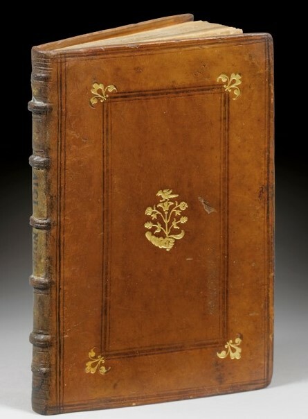
YTB-71Paris, Michel Vascosan, 1533-1532. 2 parties en 1 volume in-12 de 101 pp., (1) f. bl., (32) ff. Veau fauve, triple filet à froid encadrant les plats, fer doré au centre des plats représentant un bras tenant une branche surmontée d’un oiseau, fleurons d’angle, dos à nerfs, pièce de titre bipartite manuscrite sur vélin. Reliure parisienne de l’époque. 161 x 100 mm. PREMIERES EDITIONS RARISSIMES DONNEES A PARIS PAR MICHEL DE VASCOSAN EN DECEMBRE 1532 POUR LA VERSION GRECQUE ET EN 1533 POUR LA TRADUCTION LATINE DE MARCILE FICIN. Alcinoos le Philosophe est un philosophe platonicien, actif vers 150, qui relève du moyen platonisme, contemporain de Lucien de Samosate. Jakob Freudenthal, philosophe allemand, identifie "Alcinous philosophus", Alcinoos le Philosophe, avec "Albinus Platonicus", Albinos le Platonicien. D'autre part, Joseph Whittaker penche à faire une seule et même personne d'Alcinoos le Philosophe, de tendance platonicienne, et Alcinoos le Stoïcien, car « depuis le 1er s. av. J.-C., le stoïcisme et le platonisme se sont à ce point rapprochés que, sans risquer la contradiction, on pourrait dire d'un philosophe qu'il est en même temps stoïcien et platonicien ». On lui doit un exposé scolaire de la pensée platonicienne : Didaskalikos, traduit par Pierre Louis sous le titre Épitomé puis par Enseignement des doctrines de Platon. Alcinoos est le premier à exposer les trois voies de connaissance de Dieu : voie négative, voie analogique, voie éminente. Alcinous florissait au Ier siècle après J. C. Formé à l’école d’Alexandrie et fidèle à l’esprit de cette école, il commença le premier à mêler à la doctrine de Platon les opinions d’Aristote et les idées orientales. (Dictionnaire des Sciences philosophiques, pp.48-49). Une des célèbres reliures parisiennes de La Renaissance réalisées pour Marcus Fugger (1529-1597). Élégant exemplaire relié à Paris pour Marcus Fugger (1529-1597). Issu d’une des plus riches familles européennes, Marcus Fugger, fils d’Anton Fugger, banquier attitré de Charles Quint, « fut lui même banquier de la ville d’Augsbourg et conseiller de Rodolphe II. Son goût pour les livres et les splendides reliures à décor en a fait le rival de Mahieu, de Grolier et de Battista Grimaldi. Quant aux reliures de sa bibliothèques, elles sont en veau fauve glacé, d’une exécution parfaite : dos à nerfs, et sobre décor sur les plats, rehaussés de fleurons d’angles, et d’un fer central caractéristique. Une partie de la collection passée dans la famille des princes d’Öttingen-Wallerstein, fut dispersé en vente publique à Munich dans les années 1930 (Catalogue IV, Munich, 1935, n° 185). Les exemplaires arborent en guise d’ex-libris, tantôt ses initiales, tantôt, comme c’est le cas ici, sa signature autographe au contreplat. En l’espèce il s’agit de l’ « association exceptionnelle d’un texte majeure de l’histoire européenne et de l’une des provenances les plus enviables de la Renaissance ». Edition très soigneusement imprimée par Michel Vascosan, illustrée de nombreuses initiales gravées sur bois. USTC n’en localise que 9 exemplaires institutionnels dont aucun aux États-Unis. Très bel exemplaire provenant de la bibliothèque de Marcus Fugger (1529-1597). On trouve sa signature monogrammée à l’encre brune sur le premier contre-plat.