2 675 résultats
56-0332San Francisco Calif.: Southern Pacific Company 1950 revised 1959. Map. Blueline print 28" x 49" with extensive brown red blue orange and green pencilling indicating zones and yard limits. From French Camp to Calaveras River and San Joaquin River to US 99/Manteca Road. Includes Index to Industries wiith approx 250 listings. Scale 1" = 800'. with insert showing Rough and Ready Island scale 1" = 2000'. San Francisco, Calif.: Southern Pacific Company, 1950, revised 1959. unknown
56-0257San Francisco Calif.: Southern Pacific Company 1946. Map. Blueline print 36" x 67." From Fruitvale to Hayward with Melrose Mulford Stonehurst Russell City. Includes proposed Highway Route 69 shaded. With Key to Industries approx. 40 listed. Includes Scale 1" = 1000'. San Francisco, Calif.: Southern Pacific Company, 1946. unknown
1911100851Souvenir pamphlet 8vo colored printed pictorial wrappers illustrated 16 pp. Folded and creased down the middle with a little wear at the fold some minor rubbing to wrappers normal aging; otherwise very good. This is a scarce piece of ephemera commemorating the 1911 groundbreaking ceremony by President William H. Taft for the exhibition in the Golden Gate Park. While the purpose of the exhibition was to celebrate the completion of the Panama Canal it seemed to function more as a worlds fair held in San Francisco. It took over three years to construct and the exhibition ran from February through December 1915. There are a number of black and white photographs in the booklet including a double page panoramic view of the city of San Francisco. The activities of the ceremony are recorded in this pamphlet which feature speakers songs marches and what they had for dinner Blair-Murdock Co.,
194064220N.P. Washington D.C.: N.P. Prepared and distributed by Army Orientation Course Special Service Division ca. 1940. One double-atlas folio colour map sized 38 x 41.75 in. colour lithograph on thick paper stock fold creases as issued minor age toning some minor edgewear slight weakening to fold creases at corners still a VG bright copy. First edition thus of this nicely executed map issued possibly printed by the Army Service Forces Orientation map series sometime during the Second Sino-Japanese War and possibly just prior to U.S. entry into World War II indicating much of the Pacific was still dominated by the Japanese Empire - Taiwan with Formosa Seoul Korea still indicated as Keijo Chosen as well as Port Arthur still indicated as Ryojun now Lushun China. The map features latitude and longitude lines but no coordinates with the Northeastern corner depicting the Aleutian Islands of Attu and Agattu Northwestern Corner Nepal & Tibet Southwestern corner ocean and Java & Sumatra while the Southeastern corner caputres the Coral Sea and tip of Australia coloured blue with white and brown. This has some similarities to the “waterproof†maps issued. No legend or printing information supplied. Worldcat locates 1 copy U of MT Mansfield Library also copy located at NIOD Instituut voor Oorlogs- Holocaust- en Genocidestudies Netherlands No. 6101. N.P., Prepared and distributed by Army Orientation Course, Special Service Division?, unknown
18848725Portland: Published by Authority 1884. Edition Unstated. Hardcover 3/4 Leather. Very Good Condition. Published by Authority Portland 1884. Edition Unstated. Very Good Condition. Non-Fiction Light exterior wear. Internally clean binding sound. -- Some later ordinances published in a newspaper pasted to blank leaves at the rear. Some annotations in ink througout the text pertinent to the published material. 3/4 black leather and cloth with COUNCIL CHAMBER in gilt on the front cover. -- Printers label pasted inside the front cover top left: R. H. Schwab & Bro Leading Printers Binders and Paper Rulers. 5 washington Street Portland OR. Size: Octavo standard book size. 437 pages. Item Type: Non-Fiction . Quantity Available: 1. Category: Politics & Government; Pacific Northwest; Oregon; United States; 19th century; Pacific Northwest; Antiquarian & Rare. Pictures of this item not already displayed here available upon request. Inventory No: 8725. Published by Authority hardcover
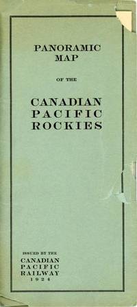
192453471N. P.: Privately printed 1924. 1924. A lovely color pictorial map 17" x 45.5" folding to 8.5" x 4" and showing the route of the Canadian Pacific from Calgary and Macleod in the east to Vancouver and Seattle in the west as well as several shorter branch lines. Map has a split at one fold but is otherwise in fine condition. Over-sized folder has chips and tears. Includes excellent detail of topography with different mountain ranges identified and names and elevations given for many individual peaks. Parks are also identified as are numerous small towns. Steamer lines are shown in Kootenay Lake Arrow Lake Okanagan Lake and the Straits of Georgia and Juan de Fuca. There is a table of distances at the lower right and an inset map of the coastline from Seattle to Skagway Alaska. Privately printed, 1924. unknown
56-0237San Francisco Calif.: Southern Pacific Company 1947 revised 1949. Map. Blueline print 35" x 78" with multicolor lines indicating switching zones. Map from San Francisco Bay to San Leandro and north Berkeley to Alameda and Oakland airport. Index of Industries with approx. 600 entries. Scale 1" = 1000'. San Francisco, Calif.: Southern Pacific Company, 1947, revised 1949. unknown
56-0330San Francisco Calif.: Southern Pacific Company 1950. Map. Blueline print 42" x 73" with extensive red purple orange and green pencilling indicating structures zones yard limits track lines and crossings. From French Camp to Calaveras River and San Joaquin River to US 99/Manteca Road. Includes Index to Industries wiith approx 250 listings. Scale 1" = 800'. with insert showing Rough and Ready Island scale 1" = 2000'. San Francisco, Calif.: Southern Pacific Company, 1950. unknown
51-0841Sacramento Division: 1937. Original blueprint dated Nov. 1937. 24 x 55 inches. Scale 1"=100'. Detailed plan of the buildings. Sacramento Division: 1937. unknown
56-0462San Francisco Calif.: Southern Pacific Company 1953 rev. 1960. Blueline print 24" x 66". From intersection of railroad tracks with State Highway 74 to approx 1 1/4 miles northwest. Few buildings plan primarily indicates track measurements and signals. With Engine House private road crossing. Scale 1" = 100'. San Francisco, Calif.: Southern Pacific Company, 1953, rev. 1960. unknown
51-0843Sacramento Division: Updated to 1961. Original blueprint dated 1961. 15 x 55 inches. Shows all the tracks and plat plans all throughout Woodland to Sugarfield with the mail line to Portland. Annotated in red by hand. Scale 1"=100'. Very useful for Phase 1 EIRs. Sacramento Division: Updated to 1961. unknown
18920008437Chicago: Rand McNally 1892. First edition. Hardcover. Very Good. 12mo 226 pages original brown cloth bright gilt rehinged <br/><br/>"Spears favors his readers with an intimate word-picture of Death Valley as it appeared in 1891. . It is noted for its early photographs in almost the same degree as for its textual content. It is conceivable that these may be the first pictures ever published - perhaps ever taken - of the Death Valley region. Maximum importance attaches to them - Edwards ENDURING DESERT p.227." Howes S821; Cowan p.604; Graff 3926; not in Soliday; Paher 1844. With a map of the Borax Fields and 56 photographic illustrations per Contents pages. Rand McNally hardcover
194677869Washington DC: U. S. Government Printing Office 1946. Presumed First Edition First printing thus. Hardcover. Good. Volume I xv 1 1-286 pages. Volume II 287-576 pages. 2 volumes. Illustrations including fold-outs. Maps. Tables. Index. Cover has wear and lettering has fading. Corners bumped. The United States Strategic Bombing Survey was a written report created by a board of experts assembled to produce an impartial assessment of the effects of Anglo-American strategic bombing of Nazi Germany during the European theater of World War II. After publishing its report the Survey members then turned their attention to the efforts against Imperial Japan during the Pacific War including a separate section on the recent use of the atomic bombs. In total the reports contained 208 volumes for Europe and another 108 for the Pacific comprising thousands of pages. The reports' called strategic bombing "decisive". This is designated OPNAV-P-03-100. It includes lists of Interrogations arranged numerically and by subject matter. It has an index of major battles operations and Japanese officials It includes in volume II Japanese notes of battles and brief biographies of Interrogated Japanese Officials. The interrogations were conducted in Tokyo during the final months of 1945. The purpose of the interrogations was to gain evidence for an assessment of the role of airpower in the war with Japan. Permission was obtained from General MacArthur to retain a nucleus of experienced officers at the Naval War College at Hiyoshi. In addition to being interrogated on their particular specialties and experiences these officers performed research at the direction of the Naval Analysis Division and together with the Japanese Naval Liaison Officer gave useful assistance in identifying and procuring other officers for interrogation. U. S. Government Printing Office hardcover
191363071Seattle WA: Seattle Union Record 1913. Folio. 9 x 12 in. 132 pp. With photo illustrations text illustrations illustrated ads throughout. Colour-illustrated softcovers cover art of miner holding pick-axe w/ Seattle waterfront in the background in tan & blue Rainier Beer advertisement on back cover minor chipping head & foot of spine dustsoiling & soiling front cover minor bumping to corners still a G copy. First edition of this scarce and important supplement issued in conjunction with the 33rd Annual Convention for the AFL composed of craft unions for cigar makers garment workers carpenters electricians and others. They also served as the umbrella union for the United Mine Workers of America and at the time were supporting the Coal strike in Colorado as well as the Michigan Copper strike organized by the Western Federation of miners. Union locals such as the Brewery Workers Women Waitresses Women Garment Workers the women’s Union Card & Label League and others include sections on their histories labor organizing and philanthropic efforts. Worldcat locates 5 copies NYPL Bancroft Seattle Public U of W U of MI Seattle Union Record, paperback
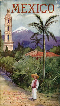
190753081St. Louis: Sam'l F. Myerson Prtg. Co. n.d. ca 1907. ca 1907. 8 3/4" x 5" in colorful pictorial wrappers. 52pp. Map. Black and white illustrations throughout. Information on preparing for a trip to Mexico followed by information and photographs of what might expect to see and experience along the way from St. Louis to Mexico City. Photographs and information on Topo Chico Monterrey Saltillo Cedral Bocas San Luis Potosi Tampico Queretaro Patzcuaro Chapultepec the Viga Canal Mexico City bullfights ancient pyramids etc. A wonderful collection of photographs taken by S.W. Matteson C.W. Archer and C.B. Waite. Fold-out map 14 1/2" x 8 3/4" showing system route from St. Louis to Mexico City inside rear wrapper. Covers and title page lightly soiled. Crease at top corner of front wrapper and with 1/2" closed tear along with scuffing and rubbing to both wrappers and to spine. Very good. A very nicely produced booklet. Sam'l F. Myerson Prtg., Co., n.d. [ca 1907]. unknown
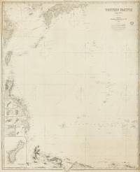
1884143681London: James Imray and Son 1884. Very Good. London James Imray and Son 1884. A very large engraved chart printed on two sheets combined printed surface 1268 × 1015 mm overall total size 1280 × 1048 mm mounted on the original blue backing paper with the publisher's title-label on the verso. Chips and short tears to the margins in a few places clear of the printed surface; a few small light stains and other minor signs of age and handling; in very good condition with faint pencil annotations tracking a voyage to Hangzhou in September 1888. A very large and detailed blueback chart of the western rim of the Pacific Ocean including the East China Sea Philippine Sea and parts of the coastlines of Japan Korea China Taiwan the Philippines and New Guinea. It features eight inset charts: Guajan Island; Borodino Island; Umata Bay; Farralon de Medinilla; Rota; Alamagan; Guguan; and Rosario Island. Both sheets incorporate corrections to June 1884. <p>The title-label on the verso reads 'Chart No 193. Western Pacific in Seven Charts. Chart No. 4. Price 8s.'. James Imray and Son unknown
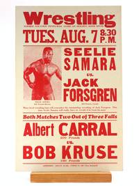
1939505696Hood River News 1939. Paperback. FINE. Printed Red on 11 x 17' white cardstock. We date this poster around 1939 based on martching Hood River News wrestling broadsides with dated newspaper clippings. 'Former location Penny-Wise Store on Heights Hood River.' Some very trivial rubbing to the tips otherwise uncommonly clean and sharp. Top billing heavyweight match features an absolutely yoked and glistening Seelie Samara stage-name for George Hardison an African-American athlete and one of the most prominent characters in the early years of the 'Golden Age' revival of dramatic/entertainment wrestling in America. Hardison was born in Georgia and after a stint as a carnival strongman was scouted by 'Tiger Man' John Pesek who became his boxing trainer. Sometime in the late 30's Hardison began competing in staged Wrestling matches in the Northeast. In 1938 he signed with promoter Jack Pfefer with whom he began traveling extensively; while he was regularly billed in the Midwest and California this broadside is the only record we found of Pacific Northwest appearance. From the early-40's onward Hardison's appearances were confined to segregated 'Race Matches'; he would hold claim to the 'Negro World Heavyweight Championship' belt through the early 50's. Cory Santos writes 'A fan favorite Samara had power and technical prowess in equal measures. His muscularity was unique for the era; his bulging physique was a striking contrast to the bulkier frames of many heavyweights of the period. The Samara character also included costume elements — the most noteworthy of which was a Muslim head wrap Hardison used when being advertised from Algeria his most common birthplace or Afghanistan. Still given the huge number of strange hometowns it is difficult to keep track of exactly what character elements are geographically based and which are just random items based on the fanciful imaginations of “Africa†from countless midwestern promoters. But a sense of fair play honor and respect defined the Seelie and variants Ras and Haille Samara characters to audiences. Combined with his impressive physique these virtues earned him lasting nicknames including “Negro Hercules†“Black Adonis†the “insert location here Wildman†and famously the “Black Panther.†'Seelie Samara: A Forgotten African-American Great.'. [Hood River News] paperback
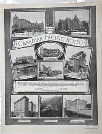
1918P3768Montreal Canada: The Montreal Standard Publishing Co. Limited; Canadian Pacific Railway c. 1918. Very Good. Notes: Advertising poster showing various Canadian Pacific Hotels across Canada. Image Size : 539x425 mm 21.22x16.73 Inches Platemark Size : Paper Size : 595x463 mm 23.43x18.23 Inches Coloring: Black & White Medium: Offset print after Notman's photographs Categories: Advertising The Montreal Standard Publishing Co. Limited; Canadian Pacific Railway unknown
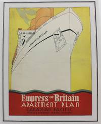
1920P4221Montreal: Canadian Pacific c.1920. Very Good. Laid on acid free paper for long term preservation. Notes: A charming advertisement for the Empress of Britain one of the flagships of the Canadian Pacific Fleet during the early part of the 20th century. Image Size : 305x246 mm 12.01x9.69 Inches Platemark Size : Paper Size : 353x281 mm 13.90x11.06 Inches Coloring: Printed in Color Medium: Lithograph Categories: Advertising; Transportation Ships; Posters; Canadian Pacific unknown
1890300405Pacific Electric Railway 1890. 1890. Photograph depicting 37 passengers at the Echo Mountain Terminal 3500 feet above sea level with printed descriptive information on the verso of mount with pictorial borders. 4 1/2" x 7 3/4" image on stiff 10" x 7" mount. No Binding. Very Good/No Jacket. Pacific Electric Railway [1890]. unknown
194064224New York NY: Fortune Magazine March 1940. One atlas folio sized map 22.25 x 27.5 in. archivally mounted on linen sized 26 x 31.25 in. in excellent bright condition. First edition of this eye-catching pictorial map celebrating the regions resources and inhabitants of Washington & Oregon chronicling the impact of the New Deal programs including the construction of Bonneville Dam and ongoing massive project of the Grand Coulee. The 1940 Fortune magazine which highlighted the growing economic potential of the Pacific Coast states including Washington Oregon & California details as well through charming caricature pictographs including sheaves of wheat cattle salmon fishermen logging tulip growers apple and peach growers Native American Reservations and more. Petrucelli 1907-1994 launched his career as a textile designer later began illustrating for House Beautiful Fortune Magazine The New Yorker and Collier’s Today who would illustrate charts diagrams cover art caricatures and won several important design awards. During World War II he also illustrated propaganda maps and ALCOA maps detailing the company’s worldwide operations. Worldcat locates 3 copies UCT Buffalo & Erie Pub. Lib. U of O. Fortune Magazine, unknown
188263407New York NY & St. Paul MN: The Northern Pacific Railroad Co.; Printed by E. Wells Sackett & Rankin 1882. 8vo. 81 1 pp. With double-page frontisp. birds-eye woodcut view of Portland OR stretching out to Mount Rainier south to Mt. Hood 9 woodcut-engraved plates. Pink-tinted printed softcovers decorated lettering minor creasing egewear slight chipping at corners without the folding map still a good reference copy. First edition of this informative land promotion issued by the Northern Pacific Railroad upon completion of its line to the Pacific Northwest from St. Paul MN in conjunction with Jacob Kamm’s Oregon Railway & Navigation Co. The views include the two-panel birdseye of Portland OR as well as views of Astoria a Puget Sound sawmill Commercial Street in Seattle of the Washington Territory and includes a mention of Chinese-Americans employed to build the railroad and now available to take contracts for “grubbing brush land.†The Northern Pacific Railroad Co.; [Printed by] E. Wells Sackett & Rankin, paperback
177521548Paris 1775. Very good condition. Large detailed copper engraved map of Captain Cook's voyage in the Resolution of New Caledonia and the New Hebrides islands in the south Pacific with the tracks and the dates indicated. From Prevost's "L'Histoire Generale des Voyages".<br /> <br /> Bellin 1703 - 1772 one of the most noted French mapmakers of the 18th century was named the hydrographer chief cartographer to the French Navy and later the Official Hydrographer to the French King.<br /> <br /> Folding 19 x 15 1/4". Strong impression very clean. unknown
1874M7526Montreal: The Desbarats Litho & Publish Co. c.1874. Very Good;. Notes: The map is based on Capt. Vancouver's survey 100 years earlier and improved with the latest survey by Canadian Pacific Railway. Size : 489x624 mm 19.25x24.57 Inches Coloring: Black & White Category: Maps Canada West British Columbia; The Desbarats Litho & Publish Co., unknown
19713105Portland Oregon: Geneva Hale Quigley 1971. First Edition. Fine/near fine. Tall 4to 168pp color and b&w illustrations. Signed by the artist with an original ink sketch on the first free endpaper of a western scene man walking through the ranch yard with a pail and milking stool to milk a cow that is looking back at him Chickens in the yard Fence buildings and clouds in the background Sketch is nicely centered on the page and is approximately 4"x5" Under his signature Quigley has written "1st Edition". Unclipped dust jacket. --. [Geneva Hale Quigley unknown