[Union Pacific Land Department]Biblio.com
2 675 résultats
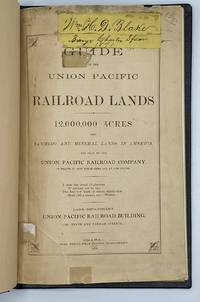
18709707Omaha: Omaha Herald Steam Printing Establishment 1870. First Edition. 44pp. Octavo 23 cm Black buckram with the title gilt stamped on the front board. Original printed salmon wrappers bound in. New endsheets and pastedowns. Manuscript label to head of original cover with paper of a similar color attached to the head of the verso. Small lib. ink stamp with accompanying 'Discard' stamp to title page. Complete with all three maps including the fold-out map 'Map of the Union Pacific Railroad Line in Nebraska' 19.5 cm x 56 cm / 7.5" x 22".<br /> <br /> Land promotional work from the Union Pacific encouraging the settlement of three million acres of U.P. lands that divides the available lands into three groups: agricultural lands the first 350 miles west of the Missouri River grazing lands from the forks of the Platte through the Laramie Plains in Wyoming and mineral lands between the Black Hills and the Wasatch Mountains. <br /> <br /> "No section of the United States furnishes facilities for grazing and stock raising superior to Nebraska and the lands on the line of the Union Pacific Railroad. The rich bottom lands of the valleys of the Platte Elkhorn Loup Fork Papillion Maple Shell Logan and Pebble Creeks Wood River Wahoo and Big Blue are included within these limits and present extensive tracts of the finest meadow land in America." Eberstadt 115: 856 later edition. Graff 4238 later edition. Herd 2351 later edition. Uncommon. Omaha Herald Steam Printing Establishment unknown
0006888San Francisco: The Bancroft Company 1893. First edition. Very Good. 12mo 64 pages 3/4 morocco scuffed marbled boards original pink wrappers bound in. Ex libris Cyrus H. McCormick son of the inventor; he was Chairman of International Harvester Corp. Scarce WorldCat cites only 9 copies. <br/><br/>Bennett was the Editor of "Bennett's Own" a weekly Hawaiian newspaper. He also authored the HONOLULU DIRECTORY and SKETCHES OF HAWAIIAN HISTORY. Forbes 4409 . The Bancroft Company hardcover
1850DEMO015143ILille France: L. Lefort 1850. Stated Second edition. Hardcover. Very Good. steel-engraved frontispiece. 8vo 258 pages 20th century half sprinkled calf marbled boards original wrappers bound in place. <br/><br/>Needs to be read with de Smet's LETTERS AND SKETCHES . AMONG THE INDIAN TRIBES OF THE ROCKY MOUNTAINS 1843 which contains several letters not included in this French text; but this French text "contains material not found in the English - Wagner-Camp-Becker 113a:5." Howes M288; Graff 3831; Monaghan 1332. Binding by "Reliure Francais". Issued in the Bibliotheque Historique et Morale this is actually the Third French Edition. Steel-engraved frontispiece. L. Lefort hardcover
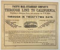
186740392New York 1867. Oblong broadsheet 9-1/2" x 11-1/2." Attractively printed within a ruled border with several type styles and sizes and engraved vignette of a steamship. The number '110' printed in lower margin beneath the border. Signed in type at the end "F. R. Baby Agent." Advertisement on verso for "Simons Brothers & Co. Manufacturers of the Metropolitan Shirt. . . Boston." Light foxing Very Good.<br /> <br /> "One of the above large and splendid Steamships will leave Pier No. 42 North River foot of Canal street at 12 o'clock noon on the 1st 11th and 21st of every month. . . for APSINWALL connecting via Panama Railway with one of the Company's Steamships from Panama for SAN FRANCISCO touching at ACAPULCO. Those of the 1st touch at MANZANILLO.<br /> "Families in Second Cabin and Steerage taken at reduced passage rates.<br /> "An allowance of one-quarter on through rates to clergymen and their families and school-teachers going to practice their vocations."<br /> According to Wikipedia "The Pacific Mail Steamship Company was founded April 18 1848 as a joint stock company under the laws of the State of New York by a group of New York City merchants. Incorporators included William H. Aspinwall Edwin Bartlett American consul at Lima Peru and also involved with the Panama Railroad Company Henry Chauncey Mr. Alsop G.G. Howland and S.S. Howland. The Pacific Mail Steamship Company was established to carry US mail on the Pacific leg of a transcontinental route via Panama."<br /> OCLC does not record this as of August 2024 nor does AAS; but the Huntington owns a copy "Date is determined by the vessels listed in the print". unknown
18561004314to original cloth rebacked with original spine strip laid on new endpapers. Illustrated with 20 of 21 color lithographs several steel engraved charts and shell engravings and three color lithographed folding maps. Table of contents list 20 color plates but some copies seem to have twenty-one. Two of the folding maps/charts have been placed in a rear endpaper pocket; one has a neat repair. A little rubbing to cloth and some minor darkening within. Could be missing one plate. Overall very good and nicely restored. One of the great sources of information on the west the Pacific Railroad Reports also contains some great illustrations. This installment Vol. III is no exception. Included are some interesting and colorful pictures of the Mojave Indians and their territory. This report contains intelligence on an expedition near the 35th parallel which took the southern route due west to the Pacific Ocean from Fort Smith Kansas that was conducted by Lieutenant A.W. Whipple and assisted by Lieutenant J.C. Ives. Ives would make his own mark on western expansion a few years later in his travels on the Colorado River. Wagner-Camp 263 Beverly Tucker hardcover
56-0290San Francisco Calif.: Southern Pacific Company 1920 revised 1937. Map. Blueline print 24" x 54". From Cypress Ave to Phelan Ave. Only streets indicated west of Meridian Road approx. 50 industries indicated directly on map. Scale 1" = 500'. San Francisco, Calif.: Southern Pacific Company, 1920, revised 1937. unknown
56-0289San Francisco Calif.: Southern Pacific Company 1920 revised 1926. Map. Blueline print 24" x 54" with mauve red and green highlighting. From Cypress Ave to Phelan Ave. Only streets indicated west of Meridian Road approx. 40 industries indicated in downtown and West San Jose. Scale 1" = 500'. San Francisco, Calif.: Southern Pacific Company, 1920, revised 1926. unknown
56-0226San Francisco Calif.: Southern Pacific Company 1947 revised 1949. Map. Blueline print on vellum. 35 x 78 inches. With multicolor lines indicating switching zones. Map from San Francisco Bay to San Leandro and North Berkeley to Alameda and Oakland Airport. Index of Industries with approximately 600 entries. Scale: 1 inch = 1000 feet. San Francisco, Calif.: Southern Pacific Company, 1947, revised 1949. hardcover
56-0367Portland Ore.: Southern Pacific Company 1923 rev. 1949. Map. Blueline print 39" x 96". Along Williamette River extending approx 1 mile each direction from banks from Clackamas County border to east end of Southern Pacific railroad yard. With Index to Industries sorted by location and owner approx 650 listings indexed by number to map. Scale 1" = 400'. Portland, Ore.: Southern Pacific Company, 1923, rev. 1949. unknown
58-0491San Francisco Calif.: Board of State Harbor Commissioners n.d. Blueline print 50 inches x 11 feet. Several small tears no missing material. From Twenty-fourth Street to Ferry Building Mission Rock to Van Ness Avenue Kansas Street. With inset map of The Presidio. No scale indicated. San Francisco, Calif.: Board of State Harbor Commissioners, [n.d.] unknown
56-0444San Francisco Calif.: Southern Pacific Company 1940 rev. 1964. Blueline print 24" x 78". From Goodwin Avenue San Fernando Road to Glendale Boulevard Brand Boulevard along Los Angeles street Los Angeles city limits railroad tracks. With Los Felix Boulevard Gardena Avenue. Includes names of businesses along and near railroad tracks. Scale 1" = 100'. With insert profile of track grade. San Francisco, Calif.: Southern Pacific Company, 1940, rev. 1964. unknown
56-0240Oakland Calif.: Southern Pacific Company 1930 revised 1960. Map. Blueline prints each 25" x 56". Station plan of Oakdale railroad property with approx. four blocks on each side along tracks from north of Stanislaus River to south of South St. Scale 1" = 100'. Oakland, Calif.: Southern Pacific Company, 1930, revised 1960. unknown
1914ZB583608San Francisco: Southern Pacific Company 1914. gathering in one custom binding eleven brochures promoting business residential agricultural and other opportunities in the State of California and several of its counties COMPLETE CONTENTS: California for the Settler by A. J. Wells; Glenn County California by Arthur Dunn; Sonoma County by W. Russell Cole; Fresno County by Walter B. Clausen; Sacramento County by M. B. Levick; Tullare County by M. B. Levick; Kern County by A. J. Wells; Monterey County by Arthur Dunn; Shasta County by M. E. Dillmar; Tuolumne County by Arthur Dunn; Siskiyou County by Bourdon Wilson; approximately 400 pages in all PROFUSELY ILLUSTRATED some in color original gilt stamped leather now slightly worn or discolored; overall very good. - If you are reading this this item is actually physically in our stock and ready for shipment once ordered. We are not bookjackers. Buyer is responsible for any additional duties taxes or fees required by recipient's country. Photos available upon request. San Francisco: Southern Pacific Company hardcover
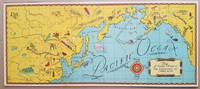
19343798<p>This delightful pictorial map focusing on the North Pacific Ocean was distributed as a premium in connection with the syndicated radio program "Air Adventures of Jimmie Allen." The program featuring Jimmie Allen as an adventurous 16-year old pilot ran from 1933 to 1937 and from 1946 to 1947 and was sponsored initially by the Skelly Oil Company.</p><p>Background on the show appears on the Radio Days Theater of the Mind Museum website http://radiodaysmuseum.org<strong>:</strong></p><p><strong>"Broadcast History:</strong> 1933 to 1937 and 1946 to 1947.</p><p>The writers of Jimmie Allen had been flying aces in World War I. They came up with the idea of a show about a boy pilot while at a party in Kansas City and used their experience as pilots to create and write the show.</p><p>The show was one of the first to capitalize on the idea of a club as a promotional tool. To join the Jimmie Allen Flying Club all a child had to do was apply at any Skelly Gas Station the initial sponsor. As a member the child received a whole host of goodies ranging from a set of wings through to a "personal" letter from Jimmie himself. An incredible 600000 club newspapers were sent out to children each week and many thousands attended the Jimmie Allen Air Races that were held in Midwest cities.</p><p>The show was first broadcast between 1933 and 1937 and then came back to the air with brand new stories after the war between 1946 and 1947. The post-war stint in no way lived up to the fascination for the show in the 1930s."</p><p>http://radiodaysmuseum.org/index.php/our-collection-1/2-old-time-radio-shows/7-juvenile/265-air-adventures-of-jimmie-allen-the</p><p>An uncommon map.</p><p><strong>References:</strong> David Rumsey Map Collection: List no. 11105.001. No examples on OCLC.</p><p><strong>Condition: </strong> Two vertical fold lines which may have been partially separated. Mounted on backing board. Very good.</p><p>ICN 7719.3</p> Skelly Oil Co.
188038887Chicago: Rand McNally & Co. n. d. ca 1880. 1880. First edition. 5 3/4" x 4" oblong color pictorial wrappers 16 pp. black & white engraved view of the "Hotel Colfax at Colfax Springs Iowa 333 miles west of Chicago and 24 miles east of Des Moines on the Chicago Rock Island & Pacific Railway." "Accommodations for three hundred and fifty guests. On the site of the famous Magnesium Chalybeate and Colfax Mineral Springs. A sanitarium for invalids and fashionable Summer Resort." Descriptive paragraphs about all the fishing grounds along the routes mostly in Illinois and Iowa with some mention of Missouri Dakota and Minnesota. Small agent's stamp at bottom of title page light evidence of a fold crease to the front cover else a near fine bright clean copy. Rand, McNally & Co., n. d. (ca 1880). unknown
1836508917Crocker and Brewster / Leavitt Lord & Co 1836. Fifth Edition. Hardcover. VERY GOOD. First Edition of what became the standard scholarly reference for New Testament Greek for the better part of the 19th century. 920pp. 4to half sheepskin leather over marbled boards marbled endpapers speckled edges. Some modest rubbing to the extremities spine a bit parched and cracking as usual with sheep tidemark to top edge of the first few pages typical age spotting otherwise a very clean sound copy. With multiple provenance inscriptions to the front matter notably for this Oregonian cataloger one 'F. W. Cathey' which is Rev. Frankly Warren Cathey b. Gresham 1863 d. Seattle 1941. Loosely tucked in between pp. 12 adn 13 is a notice of a meeting led by A. C. Scott. Both men were Methodist ministers in Oregon. Edward Robinson was one of the most prominent English-speaking Biblical Scholars in the 19th century holding professorships first at Andover-Newton and later Union Theological Seminary. 'His most important fruit . was the preparation of an independent Greek and English Lexicon of the New Testament which at once took the place of the his own translation of Wahl's Clavis. He made frequent use of his predecessors — Bruder Schleussner Wahl Bretschneider and all exegetic sources of importance; and. in the later editions particularly of the commentaries of De Wette and Meyer which he preferred on account of their great philological advantages and concise brevity without however allowing them to disturb his American orthodoxy in any important point. This extremely valuable and sterling work first appeared in 1836 and was at once welcomed as the best English lexicon of the New Test. and reprinted in three different editions in England. A new edition greatly improved and in part entirely altered appeared in 1850 and made it the first work of its kind to the present time. It is likewise an almost complete concordance and enables the student to nearly dispense with Bruder. This work is a monument of labor and industry. Its motto is 'Dies diem docet' and 'Nulla dies sine linea.'' McClintock & Strong 'Robinson was born near Southington Connecticut the-son of a Congregational minister. He was educated at Hamilton College in Clinton New York 1812-16. On a visit to Andover in 1822 Robinson fell under the spell of Moses Stuart who persuaded him to study in the seminary. In 1826 Robinson went to Europe where he studied four years primarily at Halle and Berlin. Returning to Andover he was named Professor of Biblical Literature in 1830. In 1837 Robinson was appointed to the faculty of Union Theological Seminary in New York which had been founded the year prior. William Baird History of New Testament Research II/28. Crocker and Brewster / Leavitt, Lord & Co hardcover
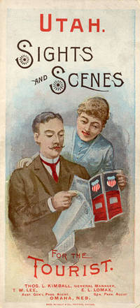
188852275Chicago: Rand McNally & Co. Printers 1888. 1888. UTAH RAILROAD. First Edition. 8vo. 21.5 x 10 cm. 8 1/2" x 4" color pictorial wrappers. 48 pp. illustrated from photographs fold-out map 'Tourist Map of Union Pacific and Connecting Lines' 20.5 x 59 cm. 8 1/4" x 23 1/2" present at the rear. The map is in nice condition and provides an excellent panorama of the Union Pacific Railway. Lines in red and run from Kansas City Atchison and Omaha to Denver and south to Gunnison or west through Cheyenne Granger and onto Portland with a spur up to Helena or west through Ogden and onto San Francisco with a spur down to Los Angeles. Blue shaded illustrations surround the lines which include a plowing scene Union Depot Salt Lake City Garfield Beach a mining scene Falls of the Yellowstone a ranching scene etc. Union Pacific produced guide for the would-be tourist of Salt Lake City including a description of the Mormons and their customs. Illustrated with nine full-page engravings from photographs by C.R. Savage. Also provided are List of Agents. Pullman Palace Car rates. Information on Salt Lake City tours Salt Lake City and the area surrounding "The Temple City" Beck's Hot Springs the Great Salt Lake Giant's Cave at Garfield Beach Echo Canon Weber Canon the Devil's Gate Ogden Ogden Canon etc. Detailed information on 9 different tours touting what the tourist might see and do. Covers lightly used light wear to fore-edges else a very good copy. Rand, McNally & Co., Printers, [1888]. unknown
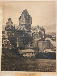
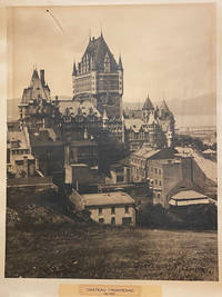
42578Artist Unknown. Quebec 1940. printed size: 68.5x 55cm 25.5"x 21.5"; frame is 90x 74cm 35.5" x 29.25" original B/W photograph some age toning as usual but a good clear image short tear on the upper right with a small puncture. . B/W historic photo of Chƒteau Frontenac an imposing hotel with five brick and stone wings and a central tower erected in seven stages between 1892 and 1993. It is prominently located on a cliff overlooking the St. Lawrence River within the Qu‚bec historic district. The Chƒteau Frontenac was designed by American architect Bruce Price as one of a series of "chƒteau" style hotels built for the Canadian Pacific Railway company during the late 19th and early 20th centuries. CPR'S policy was to promote luxury tourism by appealing to wealthy travellers. The Chƒteau Frontenac opened in 1893 five years after the Banff Springs Hotel which was owned by the same company and similar in style. Artist Unknown. Quebec, 1940 unknown
40187np. 1940. Artist Unknown. printed size: 68.5x 55cm 25.5"x 21.5"; frame is 90x 74cm 35.5" x 29.25" original B/W photograph some age toning as usual but a good clear image short tear on the upper right with a small puncture. B/W historic photo of Chteau Frontenac an imposing hotel with five brick and stone wings and a central tower erected in seven stages between 1892 and 1993. It is prominently located on a cliff overlooking the St. Lawrence River within the Qubec historic district. The Chteau Frontenac was designed by American architect Bruce Price as one of a series of "chteau" style hotels built for the Canadian Pacific Railway company during the late 19th and early 20th centuries. CPR'S policy was to promote luxury tourism by appealing to wealthy travellers. The Chteau Frontenac opened in 1893 five years after the Banff Springs Hotel which was owned by the same company and similar in style. np. 1940 unknown
1871761New York 1871. Good plus. Folding pamphlet 6 x 17 inches. Separated along one fold. A few later pencil annotations. Light wear and tanning. A scarce advertisement for bond investment in the Northern Pacific Railroad issued in 1871 during the first great construction push on the line. Although the company was founded in 1865 ground was only broken on construction in 1870 after considerable backing by Jay Cooke. This pamphlet outlines the plans for the railroad to be built from St. Paul to Portland and Seattle the prospects for passenger and freight business upon completion and the extent of the land grants afforded the railroad by the federal government. The text goes on to describe the financial instruments on offer their advantages over Treasury bonds chiefly a greater yield at 7-8% vs. 5-6% and their security against the commercial and financial assets of the railroad as well as its land grants. With a map of the proposed route on the rearmost panel. A scarce call for investment in the Northern Pacific from its early history. unknown
2002DBS-9781402071430kluwer 2002. 1st. Hardcover. New. kluwer hardcover
2002DBS-9781402071430kluwer 2002. 1st. Hardcover. New. kluwer hardcover
1856120572Washington D. C. A. O. P. : Nicholson Printer 1854-1856 1856. First Edition. Hardback. Very good copy in the original gilt-blocked cloth. Professionally recased with the original spine laid back; very impressively finished. Remains particularly well-preserved overall; tight bright clean and strong. Scans and additional detail on request. ; 1 pages; Physical desc. : 1 vol. various pagings : ill ; 30 cm. Subjects; Natural history - West U. S. . Indians of North America - West U. S. . Geology - California. Washington, D. C. , A. O. P. : Nicholson, Printer [1854-1856] hardcover
1721011121Lucca: Per Vicenzo Giuntini A spese di Gio: Riccomini 1721 Book. Good. Full vellum. 227 1 pages. In old full vellum the boards having worming but this only goes into the text block as far as page 4. Spine damaged by worming. Some pages browned. Armorial bookplate to the front pastedown of Sylvester Lord Glenbervie and armorial bookplate to the front free end paper of H.F. Davies Elmley Castle. Ink letter R to the upper outer corner of the front free end paper. Per Vicenzo Giuntini A spese di Gio: Riccomini hardcover
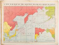
1942206849Chicago.: Chicago Daily Tribune. 28 January1942. Printed colour map 40.3 x 53.6 cm; 46.5 x 60 cm sheet inset map of the North Pacific back cover from a section of the Chicago Daily Tribune newspaper pages 21-34 January 28 1942; central fold edgewear and browning with a few minor tears not affecting the map in very good condition. Based on a Rand McNally map and issued less than two months after the bombing of Pearl Harbour by the Japanese. The Tribune briskly got to work issuing maps for readers showing the beginnings of the war with Japan. Later maps were also published for sale separately but remarkably few have survived. The map shows "the nearness of our Aleutian Island chain west of Alaska to the islands of Japan. At Dutch Harbor and other points in the Aleutians are actual and potential sea and air bases lying on the shortest route from northwestern United States to Japan." The inset map at lower right situates the areas in the larger map in respect to the countries bordering the North Pacific Ocean. <br> <br>Included with the map is the complete newspaper section from which it is the final full page. Covering sport and the market with half a dozen popular comic strips including "Dick Tracy" and "Little Orphan Annie" it shows a domestic United States a world away from what had been seen as a European War. <br> <br>". the historic Chicago Tribune was an innovator in color inks and printing but also a pioneer in bringing colorful art in the form of illustrations photographs cartoons and advertisements to the average person in an everyday medium." see The Janet A. Ginsburg Chicago Tribune Collection Michigan State University Libraries." . Chicago Daily Tribune. unknown