6 262 résultats
1870354323New York: E. & H.T. Anthony & Co 1870. Single stereocard 3½ x 7 inches. Stereo image mounted onto printed orange cardstock. Slight wear at edges. Very good. Single stereocard 3½ x 7 inches. An appealing stereocard image showing several long stretches of railroad track heading into the small town of Ogden Utah. It is a view of an important point crossing point in American railroad history as Ogden is the point at which the Union Pacific Railroad ends and the Central Pacific begins. A train can be seen on the tracks in the far distance as well as a few clapboard buildings. The New York photographic firm of E. & H.T. Anthony & Co. produced several stereoscopic views for the Central Pacific Railroad though few are known today. A nice image of an important railroad intersection. E. & H.T. Anthony & Co unknown
191476234San Francisco: Pacific Gas and Electric Co. 1914. First and only edition. Quarto 9 x 11 1/2 inches. 4 double leaves 12 double leaves of colorized photographic illustrations. Publisher's quarter brown boars over green boards green endpaper to match. Head of spine a but bumped else a bright and fresh copy.The color illustrations are all of P.G. & E works and include; Electra Power House; Cordelia Substation;De-Sabla Power House; Paterson Ranch Pumping Plant; Centerville Power House; Carquinez Straits Crossing; Spillway-Spaulding Damn; Potrero Gas Works; San Rafael Substation; Colgate Power-House; Brown's Valley Ditch; Champion Mine-Nevada County.Ostensibly issued as a keepsake for Christmas of 1914 the real reason was likely to brag about the completion in 1913 of the huge Big Creek plant the gem of the P.G & E system. It is estimated that there were over 100 hydroelectric plants operational in California by 1914. These ranged from small local plants to large-scale projects supplying power to major cities. This was a very deluxe item so it is probable that PGE presented it only major stockholders This is borne out by the fact that OCLC only records 9 copies Printing colorized photographs in books in 1914 was a very complex and costly process. Special paper had to be used thus the french-fold binding here and the technology was still in its nascent form. But the illustrations fairly burst with color. This was at P.G. & E.'s most muscular; in the 21st century the company filed twice for bankruptcy. (Pacific Gas and Electric Co.) hardcover
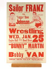
1939505695Hood River News 1939. Paperback. NEAR FINE. Printed Red on 11 x 17' white cardstock with Oregon Daily Journal clippings advertising the billing d. Wed. Jan 25 1939. A Barnstorming troup from the very early years of the 'Golden Age' revival of dramatic/entertainment wrestling in America. Top billing with wrestler photographs an intra-Northwest match between a tattooed 'Sailor' Franz and barrel-chested 'Logger' Dave of Aberdeen--both characters reflecting the respective industries of their cities. 'This match will no doubt be rough as both men are inclined to use rough tactics!' The second match of out-of-town grapplers receives no extra copy. 'ADMISSION: Adults 55c Under 16 25c First Five Ladies Free Each to be Accompanied by Paid Admission.' With 6 clippings pasted to the back side. One d. Jan 20 1939 recounts a previous bout with the same wrestlers who have now advanced to a culminating round described in a second clipping d. Wed Jan 25 1939 and which the current poster advertises. Four additional clippings eulogize 'R. V. Harrington noted wrestling referee and basketball and baseball leader who passed away Wednesday morning.' Harrington coached and referreed in several Oregon cities including Dallas Portland Newberg Astoria and Eugene. The Obituary reads: 'Mat Referee Counted Out By Master.' Two stab punches to left side some trivial rubbing to the extremities very clean and sharp otherwise with only minimal toning. Hood River News paperback
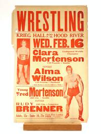
1939505694Hood River News 1939. Paperback. VERY GOOD. A Barnstorming troup from the very early years of the 'Golden Age' revival of dramatic/entertainment wrestling in America. Dated 1939 from news clippings attached to a matching poster advertising the event d. Jan. 1939 possibly a bit earlier or later. An all-Northwest billing with top position going to the women's match featuring 'Undisputed World's Champion' Clara Mortenson of Seattle who is photographed with her Champion's belt. Rudy Brenner of Longview is photographed for the men's bout. 'Adults 55c - Under 16 25c First Five Ladies FREE When Accompanied by Paid Admission.' 'Both Matches 2 out of 3 Falls to a Finish. Printed in red on white paper 11 x 17'. Two hole punched with sticker ring reinforcements to reverse. Edges worn with some creasing and moderat toning small chip to top left corner. 'One of the most popular women on the carnival circuit was Clara Mortensen the daughter of wrestler Fred 'Mart' Mortensen a former light heavyweight champion. She wrestled her first professional match at the age of seven when her father put her in the ring aginst her brother Leo at an Elks Club picnic in Portland Oregon in 1925 . She adopted the nickname 'The Eternal Woman' and laid claim to the women's championship asserting she had won the title by beating Barbara Ware in 1932 following the retirement of recognized champion Cora Livingston.' Mortenson was a pivotal figure in the history of Women's wrestling drawing huge crowds in venues in Honlolulu Los Angeles Florida Montana and Washington DC. She was featured in the Washington Times and Time Magazine and famously appeared in the 1951 noir Racket Girls a film about a gangster fronting as a women's wrestling manager. Laprande & Murphy Sisterhood of the Squared Circle: The History and Rise of Women's Wrestling. Hood River News paperback
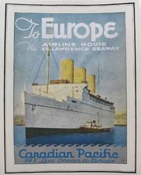
1920P4220Montreal: Canadian Pacific c.1920. Very Good. Laid on acid free tissue paper for long term preservation. Notes: A charming advertisement for the Canadian Pacific fleet sailing between North America and Europe during the early 20th century. Image Size : 279x204 mm 10.98x8.03 Inches Platemark Size : Paper Size : 328x257 mm 12.91x10.12 Inches Coloring: Printed in Color Medium: Offset Lithograph Categories: Transportation Ships; Advertising; Posters; Canadian Pacific unknown
189431668San Francisco 1894. Original staples and printed wrappers with wrapper title as issued. 12pp lightly toned Very Good.<br /> <br /> The Mass Meeting attacked the "Railroad Octopus" which assails the people "by unjust accumulations and intelligent and determined concentration of power for bad ends . . . Its cupidity its selfishness its trickery the debasing pressure exerted upon every form of industry and the unprincipled use of money and of purchased intellect by a powerful railroad monopoly has checked our progress and reduced us to virtual slavery for twenty-five years." <br /> OCLC lists twelve copies under two accession numbers as of October 2024. Not located in Rocq Cowan or BRE. unknown
18469109London: Charles Knight & Co 1846. First edition. 15x10cm 7 226pp. Frontis folding map at pg. 102. Cream blind stamped cloth with gilt spine lettering. Boards smudged spine darkened. Prelims unopened else clean internally and nearly fine. <br /> <br /> Very nice copy of this book printed for English youth and published the year in which the Treaty of Washington was signed ending the dispute between Great Britain and the U.S. over title to the Oregon Country. Tweney mentions in his Washington Eighty-Nine:<br /> <br /> "This book gives the English side of the Oregon boundary dispute and urges that the northern line of California be the natural boundary between the two countries."<br /> <br /> <br /> Besides presenting arguments the book is also very descriptive in the early settlement of the Pacific Northwest and rise of the fur trade. Not often found in the original cloth in presentable condition.<br /> <br /> Howes N151. Sabin 55251. Smith 7311. Wagner-Camp 122C:1. Washington 89 57.<br /> <br /> <br /> <br /> . Charles Knight & Co unknown
189639056N.P.: Privately printed 1896. 1896. 7" x 13 3/4" folded over twice to 7" x 3 1/2" in pictorial wrappers. 20 pp. illustrations map schedule rates 4-columns printed in red and blue ink. Information on Hotel Del Monte Monterey Santa Cruz San Luis Obispo Capitola Santa Maria Del Mar San Mateo San Jose Lick Observatory Paraiso Hot Springs El Paso de Robles Hotel Arcadia listing of Spanish and Indian names Tassajara Hot Springs Pacific Congree Springs Gilroy Hot Springs Leland Stanford Junio University Mount Hamilton Twin Lake Park Capitola the big trees of Santa Cruz etc. 7" x 13 3/4" color bird's-eye view map of California. Numerous photographs of scenery throughout brochure along with pictures of various hotels buildings points of interest. Cover wrappers lightly soiled with slight splits at spine ends and light wear to the extremities. Very good. A very interesting brochure. Privately printed, 1896. unknown
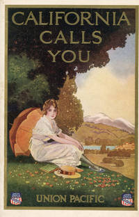
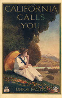
192146831Omaha: Union Pacific 1921. 1921. First edition. 9" x 6" in lovely color pictorial wrappers. 40pp. Black and white illustrations. Maps. The contents are printed on coated white paper. Southern California attractions like the Terrace Garden at Hollywood and Pershing Square in Downtown Los Angeles are featured prominently alongside Northern California destinations. Pictures include churches cityscapes scenery street scenes beach scenes etc. Center pages feature three regional Rand McNally & Co. maps. One-page map at the rear showing the Union Pacific routes west of the Mississippi. An especially fresh example with just a hint of foxing to the rear panel. Union Pacific, 1921. unknown
191346830Omaha: Union Pacific 1913. 1913. First edition. 9" x 6" in lovely color pictorial wrappers. 40pp. Black and white illustrations. Map. This brochure was reprinted through at least 1924. Unlike later editions the contents are printed on cream paper with decorative green borders. San Francisco and Northern California destinations are most prominently highlighted in this version. Illustrations include the capitol building Mt. Shasta Chinatown beach scenes street scenes scenic views missions fishing scenes etc. One page map at rear showing the Union Pacific routes west of the Mississippi. Minor smudge to the front panel with some light toning and edgewear; otherwise very good. Union Pacific, 1913. unknown
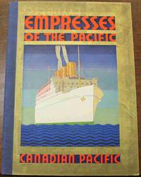
1928B5210Canada: Canadian Pacific c. 1928. The book is in very good condition. . Binding: Contemporary sturdy textured paper wrappings. Image of Empress of Japan on top cover with text above and below. Canadian Pacific brand logo on bottom cover. Notes: This book is a detailed photographic travel guide showing prospective clients what it would be like to stay in a first class or ‘tourist’ berth on one of the four flagships of the White Empress line of ships: The Empress of Japan The Empress of Canada The Empress of Asia and the Empress of Russia. Size: 4to 277x204mm. Illustration: Illustrated with numerous photographs of the inside of the White Empress ships and of travel destinations. Category: Book Ephemera; Book Transportation Marine; Canadian Pacific unknown
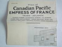
1930x1203London: Canadian Pacific Ocean Services 1930. Folding deck plan of the transatlantic steamer Empress of France showing cabins their furnishings noting other passenger and a few crew spaces; with b/w photos of the ship's cabins & amenities on the reverse. This is a general depiction of the ship not associated with any particular planned cruise. Built in 1913 for the Allan Line and christened the SS Alsatian the ship served the trans-Atlantic trade until her conversion into an armed merchant cruiser in World War One; after the war she was acquired by the CP refitted and renamed Empress of France in 1919. After a global circumnavigation in 1923 she was converted from coal to oil fuel. She continued to serve mostly the Southampton UK to Quebec route and was reconfigured twice with the configuation shown in this plan done in 1927. In 1928 & '29 she sailed in the Pacific returning to Atlantic service about the time this plan was produced. Her final voyage was in 1931 after which she was laid up in the Clyde and scrapped in 1934. The plan notes her 27600 tons displacement geared turbine quadruple screws gross register of 18400 tons length of 600 feet breadth 72 feet speed 19½ knots; space for 281 first class 368 tourist third cabin and 368 third class passengers with color key to their cabins & facilities. On its other side are nine b/w photos showing the ship drawing room bedroom of a suite smoking & dining rooms lounges. Single sheet folded several times; folded size about 19.5 by 9.5 cm 7¾ by 3¾ inches; unfolded about 75 by 101 cm 29½ by 39¾ inches. Plan in black three colors opposite in b/w only. Light wear & extraneous creasing minor splits where some of the creases cross. . First Edition. Folded sheet. Very Good. 29½" by 39¾". Canadian Pacific Ocean Services Paperback
1870WRCAM34145New York: E. & H.T. Anthony & Co. 1870. Single stereocard 3 1/2 x 7 inches. Stereo image mounted onto printed orange cardstock. Slight wear at edges. Very good. An appealing stereocard image showing several long stretches of railroad track heading into the small town of Ogden Utah. It is a view of an important point crossing point in American railroad history as Ogden is the point at which the Union Pacific Railroad ends and the Central Pacific begins. A train can be seen on the tracks in the far distance as well as a few clapboard buildings. The New York photographic firm of E. & H.T. Anthony & Co. produced several stereoscopic views for the Central Pacific Railroad though few are known today. A nice image of an important railroad intersection. E. & H.T. Anthony & Co. unknown books
2221572<p>First edition. 7" x 9". Original stiff green wrappers stamped in white cord tie oval b/w halftone photograph of water front Tacoma. Illustrated with two fold out b/w panorama views and 17 b/w mounted halftone views on stiff grey papers. Uncommon. Very good.</p><p>Printed by Albertype Co. Brooklyn N.Y.</p> P. A. Kaufer unknown books
2221572<p>First edition. 7" x 9". Original stiff green wrappers stamped in white cord tie oval b/w halftone photograph of water front Tacoma. Illustrated with two fold out b/w panorama views and 17 b/w mounted halftone views on stiff grey papers. Uncommon. Very good.</p><p>Printed by Albertype Co. Brooklyn N.Y.</p> P. A. Kaufer unknown
20049305San Francisco: Pacific Editions 2004. One of 90 copies all signed by the artist Charles Hobson each with pastel monotype by Hobson that has been reproduced as a digital pigment print with hand coloring. It is the penultimate image in the book. Page size: 5-1/2 X 4-3/4"; made from postcards translucent envelopes various papers and features the photographs of Robert Doisneau. There are 3 envelopes - each with a photograph and a fictional story about the person in the photographs. Bound: red linen spine with black paper over boards with surround of black corrugated board housed in Mylar envelope with string tie. There is a "lipstick" imprint in red on the black paper on the front cover and a photographic image of a woman's lips on the corrugated surround. The 3 Mylar envelopes housing the photographs and "story" are in orange pink and red. Other photographic images are mounted on various colored papers on the verso pages before the Mylar. Hobson may be the ultimate romantic - assembling these "kissable" images and creating fictions for them as a Valentine for his wife. The world of book arts benefits from his gesture. Pacific Editions unknown books
56-0280San Francisco Calif.: Southern Pacific Company 1928. Map. Blueline print 24" x 36" with red and black pencil markings indicating railroad track routes limits of railroad yard. Industrial map of Madera with Key to Industries including 24 entries indexed to location by letter. Scale 1" = 450' San Francisco, Calif.: Southern Pacific Company, 1928. unknown
56-0369San Francisco Calif.: Southern Pacific Company 1950 revised 1952. Map. Blueline print 17.5" x 45.5". Detail of area between yard limits from State Highway to Dibble Creek including city of Red Bluff station points Red Bluff and Glade. Partial Schedule of Property included approx 35 entries majority missing information. Scale 1" = 400'. With inset showing parcel at Breckinridge St and Washington St scale 1" = 100'. San Francisco, Calif.: Southern Pacific Company, 1950, revised 1952. unknown
58-0482Ogden Utah: Southern Pacific Company. Blueprint 19 inches x 29 inches. From Park Street and Fourth Street to Seventh Street. Note on sketch reads "With exception industries marked B-C-L-N Western Pacific have placed or spotted competitive loads on which southern pacific enjoyed line haul. Tracks serving these industries should be classified." Not drawn to scale. Ogden, Utah: Southern Pacific Company. unknown
56-0281San Francisco Calif.: Southern Pacific Company 1949 revised 1954. Map. Blueline print 24" x 36" with pencil notation. Includes State Highway 4 & 24 Standard Oil Co Camp Stoneman U.S. Government building. Scale 1" = 100' San Francisco, Calif.: Southern Pacific Company, 1949, revised 1954. unknown
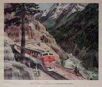
04-1224ca. 1950s. Color print. 15 x 17 inches. Stains in left margin. Framed and glazed. ca. 1950s. unknown
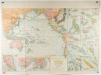
1930205997Sydney: H.E.C. Robinson. Circa1930s. Printed colour maps in all 65.5 x 99cm the main map roughly 50 x 65 cms on a single sheet 76 x 101.3 cms; a little carelessly folded decorative blue title cover a little dusty and a few fold splits and edgewear but in good condition. The exceptional feature of this map are the twenty six large scale inset maps of Pacific islands including: Malay States Singapore Hong Kong these at lower left Japan Philippine Islands Hawaiian Islands Fiji Solomon Islands Western and Eastern Samoa Tahiti Saipan New Caledonia and Dependencies and many others. <br> <br>The main map of the Pacific Ocean stretches from Southeast Asia including all of Australia and New Zealand the west coast of the Americas the Kamchatka Peninsula Manchukuo Manchuria and most of China. Korea and Taiwan are marked as Japanese Territory. Possessions of Britain France the Netherlands and the United States are highlighted. <br> <br>An incredibly rich source of information on the Pacific theatre during the years leading up to World War II. From the Sydney publisher H.E.C. Robinson the firm founded in 1895 by Herbert Robinson 1857-1933 a founder of the Royal Geographical Society of Australasia. . H.E.C. Robinson. unknown
Carta geografica, racchiusa in decoartiva cornice, raffigurante l'oceano Pacifico utilizzando la proiezione cilindrica di Mercatore. In alto al centro, il titolo si trova inscritto in semplice riquadro con indicazione dei segni convenzionali utilizzati per indicare le tratte aeree, le linee ferroviarie, i principali prodotti esportati dai differenti paesi, le rotte oceaniche, i confini di stato e le capitali degli stati o delle colonie. Al centro una semplice e decorativa rosa dei venti, mentre lungo il margine inferiore si trovano sei spot circolari in sono raffigurati in particolare: Singapore, Hong-Kong, Manila, Vladivostok, Tokyo e le Isole Hawai.Particolarmente interessante è la raffigurazione della sezione nord-orientale della Cina ed in particolare delle attuali province di Jilin, Liaoning e Heilongjiang.Pieghe editoriali ed alcuni vecchi restauri alle pieghe che non compromettono il buono stato di conservazione generale e l'ottima fruibilità della carta stessa.
1767628Bourg, P.F. Bottier, sans date (1767), in-12, broché ; 143 pp. y compris la page de titre, (1) p. d’approbation par Alexis de Sainte-Susanne, Vicaire-Général des Augustins réformés (ordre de Rousselet) et De La Lande, Censeur Royal.
2006x-0470083883Amer Ceramic Society 2006. Paperback. New. 1st edition. 187 pages. 9.00x6.00x0.25 inches. Amer Ceramic Society paperback