6 262 résultats
2013x-3642263801Springer Verlag 2013. Paperback. New. 2010 edition. 353 pages. 9.29x6.06x0.87 inches. Springer Verlag paperback
2012DADAX0759121257AltaMira Press 2012-05-03. hardcover. New. 7.22x1.05x10.42. Buy with confidence. Excellent Customer Service & Return policy. AltaMira Press hardcover
A FINE SIGNED LARGE-PAPER COPY of the first and only edition of this first-hand account of a voyage to the South Pacific, including the New Hebrides (now Vanuatu), Fiji, Tonga, and numerous other places. 115 pp plus folding map. ONE OF 100 NUMBERED LARGE-PAPER COPIES PRINTED ON FINE LAFUMA WOVE PAPER, SIGNED BY THE AUTHOR IN PURPLE INK. 8vo. Original wraps. ENTIRELY UNCUT AND UNOPENED. A bit of very light foxing, else FINE AND BRIGHT
Edizione italiana della celebre carta dell’isola di Tahiti di James Cook. La presente carta è stata stampata come parte del resoconto ufficiale del primo viaggio di Cook, che fu curato dal critico letterario John Hawkesworth e sottoscritto dall'Ammiragliato britannico. An Account of the Voyages undertaken by the order of His Present Majesty for making Discoveries in the Southern Hemisphere... (Londra: W. Strahan and T. Cadell, 1773) raccontava i viaggi non solo di Cook, ma anche di Byron, Wallis e Carteret che si erano avventurati nel Pacifico per la Royal Navy in precedenza negli anni 1760. James Cook, fu nominato luogotenente al comando dell'Endeavour, un vascello di 370 tonnellate, salpò da Plymouth il 25 agosto 1768, conducendo seco J. Banks, il botanico Solander, e i pittori Buchan e Sydney Parkinson, l'ultimo dei quali acquistò fama per i suoi quadri d'interesse naturalistico. Dopo aver toccato Madera e Rio de Janeiro, doppiò il Capo di Buona Speranza e giunse nell'aprile del 1769 a Tahiti; riconobbe e rilevò l'arcipelago delle Isole della Società e, portata a termine la missione affidatagli, navigò verso SO., compiendo quasi per intero il periplo della Nuova Zelanda, dove scoprì lo stretto che da lui prese nome. Colpito dal fatto che, nonostante Tahiti fosse comunque uno scalo di estrema importanza per le navi che solcavano il Pacifico, la posizione segnata sulle carte risultava terribilmente approssimativa, Cook approfitta della sosta per calcolare anche latitudine e longitudine esatte dell’Isola, destinate ad arricchire e migliorare le attuali mappe nautiche che risultano sempre incomplete e notevolmente indeterminate. È il 13 luglio 1769 quando Cook dà ordine di salpare l’ancora, navigando sulla rotta prestabilita che dovrebbe portarlo verso Sud scopre altre isole facenti parti dell’Arcipelago di Tahiti alle quali conferisce il nome di Isole della Società, in onore appunto alla Royal Society. Acquaforte, finemente colorata a mano, in ottimo stato di conservazione. Italian edition of the map of Tahiti by James Cook. Captain James Cook (1728-1779) is considered to be the greatest explorer of the eighteenth century and was the finest maritime cartographer of the Age of Enlightenment. Having first worked on coal colliers and then distinguished himself as a surveyor in Eastern Canada, in 1768 he became the British Admiralty's choice to lead an unprecedented voyage of discovery. The central impetus for the expedition was to observe the Transit of Venus from Tahiti and then to proceed to explore Terra Australis Incognita, the supposedly rich southern continent. Whereas the first part of the voyage was to be conducted under the auspices of international scientific cooperation, the second part was entirely clandestine and was only communicated to Cook via "Secret Instructions" to be opened once at sea. Cook's party left Plymouth in August 1768 aboard the converted coal collier HMS Endeavor and proceeded to Tahiti by way of Cape Horn. They arrived in time to observe the Transit of Venus, which occurred June 3, 1769. Cook then proceeded towards New Zealand, to the coordinates recorded by Tasman. The present chart was printed as part of the official account of Cook's first voyage, which was edited by the literary critic John Hawkesworth and underwritten by the British Admiralty. An Account of the Voyages undertaken by the order of His Present Majesty for making Discoveries in the Southern Hemisphere… (London: W. Strahan and T. Cadell, 1773) recounted the voyages not only of Cook, but of Byron, Wallis, and Carteret who had also ventured to the Pacific for the Royal Navy earlier in the 1760s. Etching with fine later hand colour, good condition.
Madrid, Juan Vidal, Editor, 1880. Dos volúmenes en folio; I: 68 pp. + 160 pp. + 180 pp. + 176 pp., 2 hs. .II: 2 hs., 151 pp. + 172 pp. + 199 pp., 2 hs. Además 192 pp. que contiene los números 1 a 12 de la "Revista Geográfica". Impresión a doble columna. Con numerosas ilustraciones entre el texto, algunas a toda plana, 67 láminas fuera de texto y 7 mapas dobles, impresos en color, dibujados y grabados por Daniel (Urrabieta) Vierge. Encuadernación de época en media piel, con pequeñas faltas de la misma en lomera. Contiene el "Viaje a Nueva Guinea" de Achille Raffray, el "Viaje en el vapor Vega para realizar el Pao del Nordeste" de Adolf Erik Nordenskiöld, el "Paseo alrededor del mundo" del Barón Alexander Joseph von Hübner, el "Viaje a la Australia" de Désiré Charnay, traducido " y aumentado con importantes datos de excursiones hechas en el interior del pais" por Adolfo Suarez de Figueroa, y "Exploraciones de los Istnos de Panamá y de Darien" de Armand Reclus.
1952020577N.Y.: E P Dutton & Co. Inc / Guilt Edge Mystery 1952. 1st edition so stated. Previous owner's name at endpaper. Green cloth title in gold at spine. Light wear along edges with some light soiling. Publisher used different paper for the book and pages 97-192 are age toned while the rest of the pages are remakably white. I've seen this listed on other copies of this book. Dust jacket is heavily creased and worn especially at folds. Looks as if upper corner of rear of dust jacket had damp stain but not affecting the book. Scarce title. Author's first book and the MWA EDGAR AWARD WINNER for Best First Novel . First Edition. Hardcover. Very Good/Good. Book. E P Dutton & Co., Inc / Guilt Edge Mystery
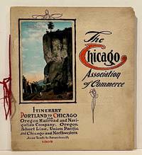
190922859Chicago: Chicago Association of Commerce 1909. First Edition. Quarto; 8pp. Four string-tied and stapled leaves with ten 3 1/2" x 5 1/2" mounted colored illustrations each titled in red along with a map of the route. Near Fine copy in grey cardstock titled and color photograph tipped to front cover. Rare promotional piece; we fine only 1 copy at University of Michigan. This booklet was prepared by the Oregon Railroad & Navigation Company the Oregon Short Line Railroad the Union Pacific Railroad and the Chicago & Northwestern Railway as an itinerary for the approximately 40 Chicago merchants' return trip ". calling your attention to a few of the points of interest in a country of marvellous scenes wonderful accomplishments and a still more wonderful future." Lists 38 members of the Chicago Association of Commerce making the return trip. Uncommon attractive & elaborate promotional piece. Chicago Association of Commerce unknown
19422092902140314022Iwanamishoten 1942. Soft Cover. Fine. Number of books: 1 Iwanamishoten paperback
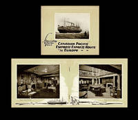
19234745Montreal QC: Canadian Pacific Railway - Passenger Traffic Dept 1923. Paperback. Fine. 1923 Canadian Pacific pamphlet featuring photographs of the interiors of the Empress of Scotland 25000 tons the Empress of France 18500 tons and the Empress of Britain 15850 tons. Lower cover w. "Printed in U.S.A.-1923" at bottom edge. Stapled wraps 24mo size 5.5 inches tall pp. 20 illustrated throughout w. sepia halftone photo reproductions. A fine copy. OCLC locates no institutionally held copies of this scarce 1923 CPR pamphlet. n.b. At time of listing we also have CP's 1924 Empresses of the Atlantic Second Class to Europe - Steamship Interior Views ; 1924 Empress Express Route to Europe - Steamship Interior Views ; and 1924 Monoclass Cabin Service to Europe - Steamship Interior Views available as well as a fine copy of CP's May 1924 Preliminary Announcement of the Mediterranean Cruise of the S.S. Scotland on Feb. 9th 1925. Canadian Pacific Railway - Passenger Traffic Dept paperback
5526nouvelle édition,revue et augmentée enrichie de notes scientifiques par François ARAGO de l’institut et précédée d’une introduction par M.Jules JANIN in 4 demi cuir marron clair,titre,filets dorés.Faux-titre,portrait de Jacques ARAGO sur chine collé,en regard portrait de François ARAGO sur chine collé.Gravés par SIXDENIERS d’après MAURIN,titre avec vignette,XII,412 pages,tranches mouchetées, illustrations gravées sur bois,dans le texte d’après Andrew,Best,Leloir,P Girardet,Lebreton,Morel Fatio, Gérard Séguin…H Lebrun 1868,Très bon état
Milano, dalla tipografia de' fratelli Sonzogno, 1824, voll. 4, in-12, br. editoriali, pp. XXXV, [1], 262 - 237, [1] - 287, [1] - 278. Con 13 tavole incise in rame acquerellate a mano (1 + 6 + 3 + 3). Resoconto di viaggio nel Pacifico (Western Australia, Timor, Hawaii, New South Wales). Prima edizione in lingua italiana, edita nella “Raccolta de' viaggi più interessanti eseguiti nelle varie parti del mondo tanto per terra quanto per mare dopo quelli del celebre Cook e non pubblicati fin ora in lingua italiana”. Ottima copia (solo lievissimi difetti ai dorsi e una piccola gora a una copertina posteriore), nella sua brossura editoriale.
591Grand in 8 pleine toile verte d’éditeur Plaque dorée animée sur le premier plat,reliure de A.Souze titre et caissons dorés au dos,frise et filets en noir sur le deuxième plat,faux-titre,titre illustré,894 pages tranches dorées,texte sur 2 colonnes,360 gravures dans et Hors-Texte(voyage en Australie,Java,Siam,Canton,Pékin, Yedo,San-Franciso.)Plon & Cie 1878(rousseurs plus ou moins fortes habituelles,une charnière habilement réparée.)sinon bon exemplaire peu courant en reliure éditeur aves premier plat historié,avec une signature à la plume de l'auteur.
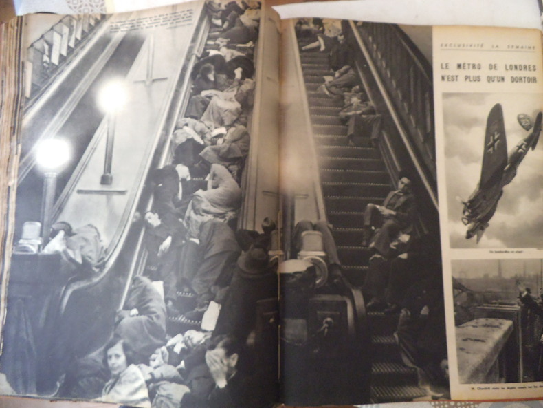
12022La Semaine 1940 à 1944 .Hebdomadaire de l’actualité mondiale. Paraît tous les jeudis. In 4 broché, couverture illustrées, , texte sur 4 colonnes, 20 pages, 32 pages. Nombreuses illustrations photos. Années 1940 à 1944 en 6 volumes demi toile à coins. 1940 : n°6 du 22 août au n°24 du 26 décembre. 1941 Tome 1 : n°25 du janvier au n° 50 du 26 juin. (sans les numéros 45-46 (qui ne sont peut être pas parus) . 1941 tome 2 : n°51 du 3 juillet pas de n° 56-57. (Suspension de la parution 15 jours) reprise au n°58 à 74 du 25 décembre. 1942 : n°75 du 8 janvier (numéros de 38pages) au n°125 du 24 décembre. 1943 : n°126 du 7 janvier au n° 164 du 30 septembre n°165 du 7 octobre au n°176 du 23 décembre 1943. N° de noël – cinéma : en couleurs. 1944 : n°177 du 6 janvier au n° 192 du 27 juillet (il manque la couverture du n° 186.) A la suite Toute la vie hebdomadaire des Temps Nouveaux. N°113 du 14 octobre 1943. N°122, 127-128, février 1944. N°152-153. A la suite numéros d’ACTU: hebdomadaire, paraît le dimanche n°65 mars 1944- n°97 98 99 (juillet 1944) n°100 (carte du front de l’est) n°100 (30 juillet 1944) L’ensemble en très non état. Environ 200 numéros. Peu courant.
19691321032Oslo, Heirs of B. Kroepelien, 1969. 4to. Titelporträt, 68 S., 2 Bl., 455 S. OLwd.
61362240Springer pp. 380 . Hardback. New. Springer hardcover
2025x-3031870263Palgrave Macmillan 2025. Hardcover. New. 336 pages. 8.26x5.82x8.27 inches. Palgrave Macmillan hardcover
8vo [21 x 14 cm]; xv, 272 pp, frontis, double page colored chromolithograph of the Queensland flowering cotton tree, 15 other plates, one illus, folding colored map. original pictorial gilt cloth, gilt lettering, small ink mark on top of spine, light foxing on some leaves, else very good. A picture of this book is available upon request by email. Rowan was both a fine botanical and wildlife artist and an explorer, acclaimed internationally for her wildflower paintings. "Flower Hunter is a book of travel and adventure, the type of book then fashionable, because the world knew less of its far places than it does today. . . Ellis knew how to hold her audience, her breathless adventures are tinged with fantasy. . ." (Hazzard in Australia's Brilliant Daughter). This is Rowan's only book on her travels, based on two journeys to Queensland in northern Australia and to New Zealand. Most of the plates in the book are from her paintings.
12mo [17.5 x 11.5 cm]; 440, 16 [ads] pp, folding map frontis, extra engraved title page with engraved view of Raiatea, table, index. later half calf, gilt title lettering on leather spine label, gilt decorations on spine, marbled boards, minor foxing in margins of a few leaves at end, else fine and clean condition in attractive binding. A picture of this book is available upon request Taylor 82: 'Full coverage of Oceana generally'. Ferguson 4141. Hill 558: 'Important and popular text'. The purpose of the work was to study 'the actual condition of the inhabitants in regard to civilization, commerce and the arts of social life'. The work includes Marquesas, Hervey or Cook's Islands, Tonga, Fiji, Navigators Islands, New Hebrides, Solomon, Sandwich Islands, Society Islands, New Zealand, etc.
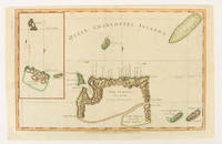
1784174895London.: Alexander Hogg at the King's Arms. circa1784. Engraved map on laid paper 21.4 x 33.7 cm inset of Gower's Simson's and Carteret's Island early outline hand colour trimmed to the plate mark at the top edge three small edge tears affecting the upper margin only slight paper toning but a most attractive map in very good condition. Fine impression of the Queen Charlotte's Islands Solomon Islands. It features the Swallow's track the ship's route taken by Captain Philip Carteret in 1767 the British naval officer and explorer who participated in two of the Royal Navy's circumnavigation expeditions in 1764–66 and 1766–69. . Alexander Hogg at the King's Arms. unknown
1870354322San Francisco: Thomas Houseworth & Co 1870. Single stereocard 3½ x 7 inches. Stereo image mounted onto printed orange cardstock. Slight wear at edges. Very good. Single stereocard 3½ x 7 inches. A very attractive single stereocard image of the Central Pacific Railroad's "Long Ravine Trestle Bridge." The bridge is located in Nevada County California in the Sierra Nevada mountain range just west of the Nevada state line. The image comes from a set sixty-two stereocards created by Thomas Houseworth & Company for the railroad some time after the railroads completion in 1869. According to the website of the Central Pacific Railroad www.cprr.org the Houseworth company produced more than one hundred such stereocards for the railroad including more than a dozen views of the 878-foot long Trestle Bridge. A nice early stereoscopic image of an engineering wonder from an important American railroad. Thomas Houseworth & Co unknown
161775296San Francisco: Pacific Gas and Electric Company 1916-17. A complete year; May of 1916 to June of 1917 12 issues Octavos. Contiguously numbered from p.1 to p. 466 plus some roman numeral pages in each issue for ads. An abundance of maps charts and photographs illustrations. Grey cloth with gilt spine lettering. All issues with their colorful wrappers bound in. An excellent little gathering.There cab be no progress without electricity so these magazines chart in a very realistic manner the growth of the state of California. The very fist article is a history of the union Iron Works of San Francisco with a full page illustration of the foundry but most of the articles are more area specific. Such articles as - ; Modernizing the San Jose Gas Works; An old-Established California Industry-the Judson Manufacturing Company; The San Francisco Dairy Company; Raising Lake Spaulding Dam; Our Pit River Project; The Rebuilding of he Sonoma County Gas Properties; Pacific Service at the Oakland Kinema Theatrte etc. . Toward the latter issues WWI starts making its appearance in the plea for war bonds. Pacific Gas and Electric Company hardcover
185275869Oregon City: Surveyor General's Office 1852. First edition. 15 3/4 x 26 inches. Printed in various shades of green blue red and black. Some light toning long fold-lines else a very good map of a vastly underpopulated Territory.The map above shows the surveyed portion of the Oregon Territory as of October 21 1852. It was prepared by John B. Preston first surveyor general of Oregon."With the establishment of the Oregon Territory on August 14 1848 all grants of claims of land in the territory were nullified. It was not until the passage of the Donation Land Act on September 27 1850 that new provisions were made for acquiring unclaimed land to be based upon government surveys. John B. Preston was appointed first surveyor general of Oregon where he arrived on April 20 1851. On June 7 1851 Preston drove the “starting stake†for the base surveys of the territory at what is today known as the Willamette Stone. The east-west Willamette Base Line and the north-south Willamette Meridian still define surveying and legal land descriptions in Oregon and Washington state.Preston and his crew were able to carry out their surveying and mapping to the extent depicted on this map in just over one year. Each square of the grid termed a section is one mile on each side and includes 640 acres of land—the maximum acreage allowed for a married couple making a claim under the Donation Land Act; a single man could claim up to 320 acres. Thirty-six sections make up a township.The surveyors took careful note of waterways hills prairies and roads. Some recognizable places are already viable communities such as Salem and Lafayette; other communities of the period—Champoeg Fairfield Cincinnati for example—have vanished as meaningful places. All three of those were river landings that were affected by floods channel changes and the eventual disappearance of river transportation. Notably absent from the map is Mission Bottom or Mission Landing the by-then-abandoned site of the Methodist mission of the 1830s and St. Paul on French Prairie. The roads that are mapped include ancient routes such as the California-Oregon Trail which had sections that paralleled both sides of the valley as well as newer roads established in recent years. The roads converging on Salem from the outlying farming districts for instance reflect its recent importance as a mill town powered by the waters of Mill Creek Surveyor General's Office unknown
19422This notable railroad was founded in 1865 by a group of San Francisco businessmen and in recent years merged with Union Pacific. Partly-printed DS 1p 5' X 7 3/4' Office of South Pacific Railroad Company letterhead St. Louis MO 1869 Sept. 27. Addressed to Joseph S. Wilson. Near fine. Invitation to attend opening of a new railroad line running between Little Piney and Lebanon Missouri. Signed by in ink at the close by the South Pacific Railroad Company president FRANCIS B. HAYES 1810-84 and below this by its resident and managing director ANDREW PEIRCE JR. -. Choice and attractive and scarce signed by this railroad's two major figures. This company merged into the Atlantic & Pacific in 1870. unknown
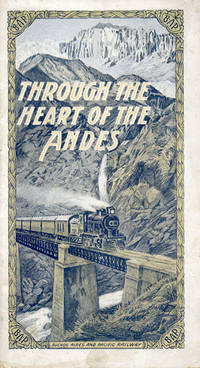
192051079n.p.: WiebeckTurtly Compani n.d. ca 1920. ca 1920. 9" x 5" in pictorial wrappers. Printed in blue and gold. 24 pp. Illustrations. Advertisements. Map showing system map of the Buenos Aires and Pacific Railway from Valparaiso to Santiago and Mendoza on rear wrapper. Information and photographs of Buenos Aires Mendoza crossing the Andes Puenta del Inca Valparaiso Santiago etc. Light soiling on wrappers and edges of pages. Very good. Wiebeck,Turtly Compani n.d. [ca 1920]. unknown