5 782 résultats
1610Map903London: John Sudbury and George Humble 1610. 1st Edition . No Binding. Vg. Folio. 44x52 cms. 38.5x51 cms The rare first edition of Speed's Kingdome of Scotland map with original outline colouring and printed on thick paper. Portraits of the Scottish Royal family border the side margins and the imprint reads' Performed by John Speed and are to be sold in 'Popeshead alley by John Sudbury and George Humble Cum Privilego 1610'. In the upper right corner is the inset ' The Yles of Orkney'. The map reverse has the text description in English. The map is complete to the margins but has been rather crudely repaired to the rear in past times and is generally a trifle grubby. Edges and centre fold repaired from the back.The top and bottom margins are wide but the side margin are close to the plate mark.The impression however being the first edition is very good with dark and clean lines throughout. The faded colouring is original with very understated with subtle lines and wash to the portraits and sea creatures. The Inital letter to the text is the first issue and by William Hall 1611-12. PLEASE EMAIL FOR PHOTOGRAPHS. <br/> <br/> John Sudbury and George Humble unknown
IN 4°, pp. 83, COPERTINA EDITORIALE IN BROSSURA CON ILLUSTRAZIONE DORATA E<BR>TITOLO , RISGUARDI FIGURATI A COLORI RIPRODUCENTI BANDIERE, 14 TAVOLE f.t. CONTENENTI 29 fig. in b/n/col. DI CARTE, PLANISFERI E FRONTESPIZI.<BR>CONSERVATA LA FASCETTA DELLA MOSTRA ORGANIZZATA UN ANNO DOPO A FIRENZE A<BR>PALAZZO STROZZI AL GABINETTO G.P. VIEUSSEUX DAL 23 MAGGIO AL 22 GIUGNO 1981.<BR>TESTO IN INGLESE, OTTIMA CONSERVAZIONE. ID 2206
1845GT070London: J&C Walker 9 Castle Street Holborn 1845. 1st Edition . No Binding. Vg. Fine hand-coloured map of the Isle of Wight and the Solent with 18 sections. Coloured boundaries sands roads woods etc. Some handling. ND c 1845. 65x44cms. Folding map covered with green boards with an original Walker's Map of the Isle of Wight label soiled but complete pasted to the front cover which is detached but present. Nice 'Tours in the Isle of Wight' pasted page to the reverse of the cover. Shows miles destinations and stops 15 x 11.5cms. Nicely hand-coloured. Title to the head of the plate with a scale of 1 inch to the mile. J&C Walker traded from 1841-1847 9 Castle Street Holborn from 1841-1847. <br/> <br/> J&C Walker, 9 Castle Street, Holborn unknown
1769Map1005London: Russell and Price 1769. Original Map . No Binding. Fine. 4to. Single page map of the County of ISLE OF WIGHT John Roque.Published in ENGLAND DISLAYED Being a New Complete and Accurate Survey and Description of the Kingdom of England and Principality of Wales. Plate 16 x20cm sheet 160 x 243mm. Fine original map printed on laid paper. Uncoloured. 2ND EDITION pub. 1769. OTHER COUNTIES ARE AVAILABLE FROM THIS ISSUE <br/> <br/> Russell and Price unknown
1991018856Spokane Washington: The Arthur H. Clark Company 1991. Brand New HARDCOVER in a Brand New dust jacket. Perfect condition. NO chips. NO tears. NO creases. NO rubbing. NO fading. Bright shiny clean square and tight. Sharp corners. NOT a library discard. NO owner's name or bookplate. NO remainder mark. Fresh and crisp - obviously never read. 1991. First Edition. A fascinating look at a geographic misconception that persisted for two centuries. Extensively illustrated with 57 historic maps. Has a 23 page bibliography of sources for additional reading. List of chapter notes. Index. Bound in the original gilt-stamped maroon cloth. From the dust jacket: "The Island of California -- this misconception flourished on and off for almost two centuries following the Spanish discovery early in the 16th century. This book traces the origin of this strange notion -- how it evolved how it kept recurring and how it was finally put to rest." Volume XIII in the Spain in the West series. First Edition. Hardcover. New/New. 8vo. 398pp. Great Packaging Fast Shipping. The Arthur H. Clark Company Hardcover
1908013882Washington D. C.: Government Printing Office GPO 1908. Very Good condition. Bound in sturdy green cloth with a gilt lettered spine. All text pages maps and plates are clean and unmarked. NO foxing. 9.5" wide by 11.5" tall. "United States Geological Survey Professional Paper 60." 84pp 170 leaves 340 pages of maps and plates mostly in full-color many double-page one fold-out. All 170 plates are printed on the rectos only right-hand side of each page with the versos being blank. There are also 34 maps and figures in the text. This volume includes well over 100 beautiful full-color maps with examples from nearly every State and Territory of the United States Geology Survey. The maps also cover topics such as glaciation coast lines volcanism faulting lakes stream piracy alluviation wind and river erosion cycles etc. This copy is from the library of geologist and author Robert B. Sosman with his small ink-stamp on the front endpaper. Keywords: Cartography. Geology. First Edition. Oversize Hardcover heavy. Very Good condition. 84pp 170 leaves 340 pages . Government Printing Office (GPO) Hardcover
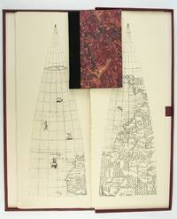
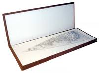
1987ST20505-11Madison Wisconsin: The Juniper Press 1987. No. 116 OF 150 COPIES. 632 x 250 mm. 25 x 9 3/4". 2p.l. 19 1 pp. <br/> Black quarter buckram over maroon marbled paper boards spine lettered in gilt. In a custom maroon buckram clamshell box. WITH 24 FACSIMILE GLOBE GORES. Signed by Woodward on the limitation page. Just a hint of use to the box booklet corners just a touch rubbed otherwise as new.<br/> <br/> This sizable attractive publication reproduces one of the largest complete sets of 16th century globe gores. Dating from around 1574 the original gores which when assembled would make a globe measuring just under 70 centimeters in diameter have been attributed to brothers Livio and Giulio Sanuto Venetian cartographers and engravers. Little is known about the gores' origin; the accompanying essay suggests they may have never made it to the final stages of publication and production possibly stopped by an outbreak of plague. This facsimile was created from the only extant set in the collection of Arthur Holzheimer 1932-2025 and was produced by his research foundation along with the Newberry Library. The gores are accompanied by a booklet by noted cartography scholar David Woodward 1942-2004 which provides background and the evidence supporting the attribution of the gores to the Sanuto brothers. The Juniper Press unknown
19871201030076Madison Wisc. : Juniper Press 1987. Hardcover. Like New. Signed. Maroon cloth portfolio clamshell case that contains 24 facsimiles sheets 24" x 9" unbound. Case is in near fine condition with very minor scuffing. Facsimiles in fine condition. Also includes descriptive booklet Cloth 8vo hardcover with marbled boards. Cover and binding are in fine condition text has clear/unmarked pages. Booklet is signed by David Woodward on its limitation leaf. - Published in a limited edition of 150 copies no. 64.This is an oversized or heavy book that requires additional postage for international delivery outside of Canada and the US. <br><br> Madison [Wisc.] : Juniper Press hardcover
320X245 mm. 248 pages. Hardcover. Cover slightly worn. In good condition. PLEASE NOTE: This item is overweight. We may ask for extra shipping costs.
340x250 mm. 152 pages. Hardcover. Cover edges and spine edges slightly bumped. In good condition.
Ril. in tela con sovr., cm 28,5x22, pp 599, molte ill. a col. e b/n.. - ISBN: 0226316335
Ril., cm 28x22, pp 64, ill. in b/n..
Includes six folded maps. 15x23 cm. 713 pages. Hardcover. Spine slightly faded. Chafe on inner cover. Ex-libris sticker on first white page. Pen writing on title page. Several pages slightly stained in edges. Else in good condition. PLEASE NOTE: This item is overweight. We may ask for extra shipping costs.
1970134434London, Heyden & Son, (1970). 4°. M. 143 farb. Ktn. 103 S. OKldr. M. Rsign. St. a. Tit.
IN HEBREW. 35x24.5 cm. 41 pages. Hardcover. Cover curved and slightly stained. Cover corners and edges, and spine edges slightly bumped/slightly worn. Cover, spine and pages yellowing. Few pages slightly age stained. Else in good condition.
First Edition, 4to, frontis., facsimiles, orig. cloth.
4to., SOLE EDITION, with a frontispiece and 9 plates of facsimiles; cloth, covers a little sunned and age-marked, backstrip faded else a very good, clean copy of a scarce work. This outstanding catalogue (compiled by Whitaker of his own collection) was published by the Brotherton Library as 'Library Publications' No. 2. It was never reprinted and is now increasingly hard to find. Sold from an institution with its small, neat stamp on front free endpaper, half-title and title only
Large folio, First Edition, with coloured frontspiece and title, 500 fine coloured maps and numerous map keys in sepia, small contemporary signature on front free endpaper; contemporary green half roan, green buckram boards ruled in gilt, green roan back with five raised bands tooled in gilt, second compartment lettered in gilt, all other compartments tooled in gilt, marbled endpapers, expertly rebacked with old backstrip laid down, a very good, bright, clean copy.
360x240 mm. VIII+120+56 pages. Gilt hardcover. Cover slightly stained. Cover slightly bumped. Cover corners bumped and slightly worn. Spine slightly yellowing. Spine edges wrinkled. Pages yellowing. Else in good condition.
198283789Baltimore: Johns Hopkins University Press 1982. First Edition. First printing. Oblong quarto 11" x 14-1/2"; cloth-backed boards hardcover in pictorial dustjacket; 128pp; illus. Mild soil to board edges else tight and clean; internally free of markings or soil; Very Good or better in the original dustwrapper. Johns Hopkins University Press unknown
198120395University of Glasgow 1981. Scale 1:63360. V.g. Folded map and cross-section sheet Two sheets the first showing a plan of the geology the second showing cross-sections at the same scale. University of Glasgow unknown
VOLUME VII IS MISSING. VOL. II, III, IV, V, VIII Contains folded maps. [VOL. I]: Books I-II / [VOL. II]: Books III-V / [VOL. III]: Books VI-VII / [VOL. IV]: Books VIII-IX / [VOL. V]: Books X-XII / [VOL. VI]: Books XIII-XIV / [VOL. VIII]: Book XVII & General Index. [ALL VOLUMES]: 11.5x16.5 cm. xliii+531+v+479+397+465+541+397+510 pages. Gilt hardcover. Top and bottom of spine are chafed. Pencil writing on several pages. [VOL. II]: Top of spine is worn. [IN CONCLUSION]: Else in good condition. PLEASE NOTE: This item is overweight. We may ask for extra shipping costs.
Contain Maps. Contain plates in black and white. [6 Volume Set Without Volume 5.] 16X24.5 cm. xiv+128+xvi+118+xvi+126+xviii+xvi+125+xviii+xvi+141+xviii pages. Softcover. Cover slightly chaffed. Cover has age stains. volume 3+6: Spine slightly worn. Else in good condition.
1758T370Dublin: John Exshaw Dame Street 1758. No Binding. Fine. 8vo. 427-480pp. A disbound copy of the Dublin version of the Gentleman's Magazine for the month of August 1758. Fine fresh paper with no foxing wear or marks. The title-page lists 24 articles on the title-page and includes a fine copy of the rare 'A PLAN of the Harbour and TOWN of LOUISBOURG in the Island of CAPE BRETON Drawn on the Spot. Folding page 28 x 20 cms with a plate impression 24 x 18 cms.4 page description of the plan and town. Other articles include an estimate of the Naval Debt; Part of the trial of William Barnard; Journal of the Seige of Louisbourg; General Abercromby's Account of the Exped. to Crown Point. Single page map of 'The Country between CROWN POINT and ALBANY being the Great Pass from the English to the French Settlements in North America'.11.5 x 19.1 cms. Please email for photos. <br/> <br/> John Exshaw, Dame Street unknown
1758T372Dublin: John Exshaw Dame Street 1758. 1st Edition . No Binding. Fine. 8vo. 313-368pp. A disbound copy of the Dublin version of the Gentleman's Magazine for the month of June 1758. Fine fresh paper with no foxing wear or marks. The title-page lists 24 articles on the title-page and includes a fine copy of the rare folding map 'A NEW MAP OF THE ENGLISH CHANNEL' engraved by Ridge 25 x 17 cms. Map engraved by Ridge. Title contents calls for a Sheet map of Germany and not the English Channel. Please email for photos. <br/> <br/> John Exshaw, Dame Street unknown