Winslow, AAntiquariat.de
MareMagnum

Studio bibliografico Editoriale Umbra · Foligno, IT10,00 €
5 782 résultats
1892245892St. Louis, 1892. M. 1 farb. Faltkte. u. zahlr. Ktn.-Skizzen. S. 57-99. OU. m. St. u. Sign. (Trans. of The Acad. of Science of St. Louis 6,3).
Each numero: Euro 10.
Each n.: 10
19121320746Washington, Government Printing Office, 1912. 4to. Porträt-Tafel, farbig illustr. Titel, 10, 567, (1) S. OLwd (angestaubt, Vorderdeckel etwas fleckig, farb. Titel gebräunt u. gering braunfleckig).
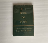
1952018855Madison: The University of Wisconsin Press 1952. SCARCE FIRST EDITION. Very Good condition in a Very Good dust jacket. SEE OUR PHOTOS. The jacket has small chips at the spine ends and corners. NOT price clipped $2.75. Protected by a removable Brodart clear-plastic sleeve. NOT a library discard. NO owner's name or bookplate. NO underlining. NO highlighting. NO margin notes. A few tiny brown speckles light foxing on the endpapers and one plate only. 1952. First Edition. A study of maps as art the importance of lettering calligraphy and type styles principles of design use of color hue intensity contrast projection etc. Figures. Tables. Bibliographical references. Bound in the original gilt-stamped green cloth. Complete with dust jacket. First Edition. Hardcover. Very Good condition/Very Good dust jacket. Illus. by NOT a library discard. 8vo. xi 105pp. Great Packaging Fast Shipping. The University of Wisconsin Press Hardcover
1964P268Amsterdam: Theatrum Orbis Terrarum Ltd 1964. facimile reprint . Hardback. Fine/Fine. Oblong 4to. xiii 60 114 118 s. : illus maps 41 fold. port. Fascimile of the first edition printed in English. Theatrum Orbis Terrarum. Series of Atlases in Facsimile. First Series Volume VI <br/> <br/> Theatrum Orbis Terrarum Ltd hardcover
214, [110 maps], 142 [index] pages. "The continual extension of commerce into new channels, the rapid growth of the colonial possessions of the British Empire, the recent territorial changes in several kingdoms, both of Europe and Asia, and the many discoveries of late years in various parts of the world, have created a demand for a new treatise in Descriptive and Political Geography." - Preface. "A capital atlas of maps clearly printed in colours, and at the very low price of one guinea. The maps are not only ancient, modern and historical, out of the Northern and Southern Constellations, and of the Planetary System - indeed, all that can be wanted in an ordinary library. This excellent book meets with our hearty approval." - The Publishers' Circular, August 3, 1875, p.526. All maps in colour with with many hinged to fold out. Includes indices with upwards of 50,000 names. Pattern of tanning marks upon endpapers suggests boards once bore a protective cover, which would account for their still brilliant gilt lettering. Narrow opening along front hinge. Dark maroon cloth decorated in black over bevelled boards is worn through along bottom edges, corners and, in spots, along backstrip. Most maps numbered in light pencil. Fold of World Map [#2] mostly open with two-inch opening affecting northern Europe. G.P. Putnam's Sons of New York appears to have also published this work in 1875. A quality copy of this marvelous Victorian era cartographic memento. Book
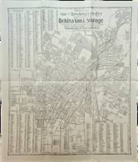
1910List3117Los Angeles California: Bekins Van & Storage 1910. Map measuring 15 ¼ x 13 ¼ inches. Folded with some wrinkling; Near Fine. A map of Los Angeles between Aldama Street South Indiana Street Slauson Ave and Arlington Street published by Bekins Van & Storage. The map is undated but based on the city’s population listed on the map—a mere 125000—it was created some time between 1900 when the population was about 103000 and 1910 when it had ballooned to over 319000. Bekins Van & Storage unknown
Second edition, revised, xx, 56pp., orig. printed wrappers.
8°, 21 cm, pp. XV, 231, numerose tavole fuori testo. Rilegatura editoriale in tela, titolo in oro al piatto e dorso, esemplare ottimo. Timbri editoriali al frontespizio e ai risguardi