2 675 résultats
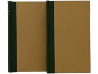
187166Boston; Nov. 1 1871. 1871 9 pp. folio. This indenture was made the first day of November 1871 between the Atlantic and Pacific Railroad Company and Oliver Ames and Charles F. Choate. The Atlantic and Pacific was to be built from Missouri and Arkansas to the Pacific Coast. From the very beginning the Atlantic and Pacific was plagued with problems even though they had the same rights as other transcontinental railroads regarding bonds land grants etc. Ames and Choate noted bankers of railroads and other various schemes were to loan to the railroad in gold coin. The amount is left blank in this document and the document is not signed by the parties. They were to be repaid in gold coin with an annual interest rate of 6%. In addition to the indenture listed above another indenture was made with George Bigeldow and James Dixwell. 2 pp. with manuscript corrections and additions. Including a provision to enable the Atlantic and Pacific to mortgage the road. This document was written earlier and does not have nearly as many provisions as in the Ames and Choate indenture. Four years later the Atlantic and Pacific would lapse into receivership. Oliver Ames then the largest stockholder purchased 96697 acres of the road's Missouri lands. After reorganization the A & P had some life until the panic of 1893 and the spoils were then divided between the Santa Fe and Frisco. These two documents are important in understanding the financial development of this railroad. Atlantic and Pacific material is quite scarce. Oliver Ames was the brother of Oakes. This railroad was to have been a very important development for Arkansas and Missouri. These documents are housed in a very attractive folding box 9 x 7 3/4 inches with green cloth-covered boards and a green morocco spine label with gilt lettering. 3214013 OG2080. 1st Edition. Hardcover. Very Good. Boston; Nov. 1, 1871. hardcover
56-0238San Francisco Calif.: Southern Pacific Company 1958. Map. Blueline print 31" x 142". Map from Bay Bridge to Hayward including Berkeley Emeryville Oakland San Leandro and Hayward. Index of Industries with approx. 1500 entries listed alphabetically. Scale 1" = 1000'. San Francisco, Calif.: Southern Pacific Company, 1958. unknown
58-0506San Francisco Calif.: Southern Pacific Company 1956 rev. 1958. Blueline print 30 inches x 112 inches. Pencilled note indicates "Richmond Switching Zones & Limits have been zoned as of Oct. 13 1960 on another industry map within file." From First Street and Linden Street to Giant and Sobrante station points. With Index to Industry listing approx 700 industries indexed alphabetically and by number to map location. Scale 1 inch = 1000 feet. San Francisco, Calif.: Southern Pacific Company, 1956, rev. 1958. unknown
56-0227San Francisco Calif.: Southern Pacific Company 1962. Map. Blueline print. 31 x 139 inches. Map from Bay Bridge to Hayward including Berkeley Emeryville Oakland San Leandro and Hayward. Index of Industries with approximately 1500 entries listed alphabetically. Scale: 1 inch = 1000 feet. San Francisco, Calif.: Southern Pacific Company, 1962. unknown
58-0505San Francisco Calif.: Southern Pacific Company 1956 rev. 1958. Blueline print 30 inches x 112 inches. From First Street and Linden Street to Giant and Sobrante station points. Colored pencilling indicates zones and districts. With Index to Industry listing approx 700 industries indexed alphabetically and by number to map location. Scale 1 inch = 1000 feet. San Francisco, Calif.: Southern Pacific Company, 1956, rev. 1958. unknown
56-0214Tucson Ariz.: Southern Pacific Company 1945 revised 1950. Map. Blueline print. 24 x 156 inches. Very detailed map of railroad yard and every lot in Phoenix along rail lines. Scale: 1 inch = 100 feet. Tucson, Ariz.: Southern Pacific Company, 1945, revised 1950. unknown
56-0219Tucson Ariz.: Southern Pacific Company 1947 revised 1950. Map. Blackline print. 24 x 164 inches. Very detailed map of West Phoenix from Ninth Avenue to Thirty-Fifth Avenue including names of plot owners and businesses. Scale: 1 inch = 100 feet. Tucson, Ariz.: Southern Pacific Company, 1947, revised 1950. unknown
56-0268San Francisco Calif.: Southern Pacific Company 1946. Map. Blueline print 24" x 220". Detailed map of Fresno along railroad lines from Roeding Park to Atchison Topeka and Santa Fe building at California Ave and Belgravia Ave. Scale 1" = 100'. San Francisco, Calif.: Southern Pacific Company, 1946. unknown
58-0479San Francisco Calif.: Southern Pacific Company 1959. Blueline print 24 inches x 9 feet. Three maps joined irregularly with red pencil indicating switching limits. From beyond Sacramento and Clear Creek to beyond City of Redding. With City of Redding station point Girvan. With Schedule of Property listing approx 50 transfers 1872 - 1959. Scale 1 inch = 400 feet. San Francisco, Calif.: Southern Pacific Company, 1959. unknown
187544494Washington D.C.: From the Press of The Henry E. Wilkens Printing Co. n. d. ca 1875. 1875. First edition. 3 3/8" x 6" pictorial wrappers 50 pp. including covers illustrated from photographs map. A train trip on the Washington Line of the Southern Pacific Company is described from Washington D. C. to California. Beginning in Washington D.C through North Carolina Alabama Louisiana Texas Arizona New Mexico southern California northern California and ending in Portland Oregon. Many interesting photographic views are shown including the Congressional Library the White House a cotton market in Alabama the French Market in New Orleans the Alamo New Mexican Indians protesting against their picture being taken views of Riverside California Los Angeles and much more. The centerfold is an interior diagram and vignettes of a tourist bedroom and sleeping car. Stamp of Alex S. Thweatt Eastern Passenger Agent Southern Railway 1185 Broadway New York on the inside front cover light wear to the spine else a near fine bright copy of one of the nicest booklets we have handled. From the Press of The Henry E. Wilkens Printing Co., n. d. (ca 1875). unknown
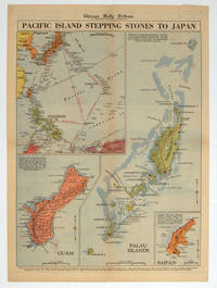
1944208880Chicago.: Chicago Daily Tribune. 28 September1944. Colour pictorial map on a single newspaper leaf archivally laid down on linen 50 x 39.2 cms; 59.3 x 43.3 cms sheet including captions faint toning to fold lines very good condition. Vivid colour maps of the Palau Islands Guam and Saipan in the Marianas and an inset location map published in the "Chicago Daily Tribune" in September 1944 months after the landing of US and Allied Forces in the offensive against the Japanese during the Pacific War. . Chicago Daily Tribune. unknown
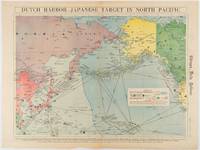
1942180751Chicago.: Chicago Daily Tribune. Friday June 51942. Printed colour map on a single newspaper leaf 37.5 x 53.2 cm; 44.7 x 59.8 cm sheet inset legend marginal browning and at the folds some undulation of paper and tide mark along lower section but in remarkably bright very good condition. Strategic map published in the Chicago Daily Tribune "The World's Greatest Newspaper" on June 5th 1942 two days after the Japanese attack on Dutch Harbor the site of the US army and navy bases in the Aleutians and as it transpired at the outset of the Battle of MIdway. The owner and proprietor of the Tribune Robert McCormick was staunchly against the United States entering the war and had firm views once it had occurred that American resources should not be used defending the British Empire. Famously the Tribune published the "Victory Program" Roosevelt’s military plan to prepare the United States for possible entry into World War II and was subject to prosecution for an alleged violation of the Espionage Act relating to the newspaper’s front-page account of the Battle of Midway 4-7 June 1942. It became an important test case for the limits of free speech and censorship during war-time. <br> <br>The Legend shows territorial Control of Ocean Areas marking Japanese Naval and Air bases as of 1941 and "according to latest reports" those established in the first six months of 1942. Also shown are pre-war sovereignties as at the bombing of Pearl Harbour on December 7th 1941. The Anson Archipelago is shown but a question mark "indicates islands etc. whose existence or give position is doubtful…". . Chicago Daily Tribune. unknown
01-0066San Francisco Calif.: Southern Pacific Railroad 1962. Map. Blueprint. 31.5 x 133 inches. Scale 1 inch = 1000 feet. April 1955 revised to Feb. 1962. With index to industries showing names and location. San Francisco, Calif.: Southern Pacific Railroad, 1962. unknown
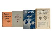
1939214021939. Various authors and issuers group of wartime pamphlets and periodicals 1939-1945 documenting American interpretations of Japanese expansionism prewar economic policy debates and U.S. military operations in the Pacific Theater. The material operates in Cultural/Representational Mode illustrating how military governmental and institutional publications framed Japanese imperial strategy and justified American military response while also presenting technical and battlefield analysis intended for both military and informed civilian audiences. These works collectively offer insight into wartime messaging strategic interpretation and the evolving American understanding of Pacific conflict from prewar trade tensions through active combat operations.<br /> Four printed works issued between 1939 and 1945 including Shall America Stop Arming Japan 1939; Japanese Imperialism Exposed: The Secret Tanaka Document 1942; United States Naval Institute Proceedings Vol. 69 No. 485 May 1943; and Makin U.S. War Department 1944. Staple-bound and softcover formats illustrated with photographs maps charts and technical diagrams. Shall America Stop Arming Japan presents statistical charts detailing American exports of strategic materials noting that Japan sourced significant percentages of copper scrap iron and petroleum from the United States accompanied by arguments advocating embargo. Japanese Imperialism Exposed reproduces the controversial Tanaka Memorial describing a proposed sequence of territorial conquest beginning with China and extending across Asia and the Pacific. Makin issued by the War Department's Historical Division provides a detailed narrative of the U.S. Marine assault on Makin Atoll with photographs of tanks infantry movement and captured terrain alongside fold-out maps showing defensive positions and invasion routes. United States Naval Institute Proceedings includes articles analyzing naval aviation logistics and strategic doctrine with photographic illustrations of aircraft such as the XLRQ-1 seaplane glider and PV-1 Ventura patrol plane as well as discussions of wartime and postwar naval policy.<br /> Together these publications trace the progression of American engagement with Japan from economic and diplomatic tension to full-scale military conflict combining advocacy intelligence interpretation and operational reporting. The juxtaposition of prewar policy argument with wartime combat analysis and technical discussion demonstrates the range of printed materials used to inform persuade and document during the Pacific War. These works support research into wartime propaganda military strategy and the informational frameworks through which the United States understood and prosecuted the war against Japan. Light wear to spines and edges with minor toning to pages; overall very good condition. A cohesive grouping illustrating the intersection of policy debate ideological framing and battlefield documentation in World War II print culture. unknown
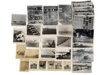
1945213921945. U.S. military operations in the Pacific Theater during World War II photograph and newspaper archive 1941-1945 documenting the Battle of Iwo Jima and the attack on Pearl Harbor. The archive pairs soldier-taken snapshots with official U.S. Navy and press photographs showing how combat equipment and battlefield conditions. The featured original snapshots contain handwritten notations en verso identifying dates specific locations soldiers and equipment.<br /> <br /> The archive comprises 39 silver gelatin photographs ranging from roughly 3.5 x 5 to 6 x 8 inches together with original wartime front pages of the Honolulu Star-Bulletin covering the attack on Pearl Harbor the fall of Italy and the Allied invasion of Europe. Images include amphibious landings on the black sand beaches of Iwo Jima with landing craft advancing under naval bombardment; U.S. Navy battleships destroyers and landing craft firing on shore defenses; and aerial scenes of dogfights and bombing runs. Close-up battlefield images depict the wreckage left in the wake of combat including destroyed landing craft craters from naval artillery and Japanese fortifications. Several photographs focus on the role of air power with images of Japanese aircraft under attack U.S. planes engaging in dogfights and B-29 Superfortresses bombing enemy positions. A particularly striking image captures a Japanese bomber scoring a direct hit on the USS Yorktown with billowing smoke rising from the carrier. Handwritten notations on some images identify U.S. servicemen locations such as Mount Suribachi and captured Japanese positions. The series of larger military-produced photographs and newspaper clippings have inscriptions on verso identifying locations and vessels depicted as well as the name tag "K .Benden." Among these are portraits of American soldiers posing at key strategic points inspecting captured bunkers and standing beside wrecked aircraft. <br /> <br /> Reconnaissance images show terrain and fortified positions; ground-level views show cratered landscapes wrecked landing craft and captured Japanese fortifications. One image shows the USS West Virginia during the Pearl Harbor attack with fire damage and crew visible; another shows a Japanese aircraft striking the USS Yorktown. Other photographs show servicemen near Mount Suribachi inspecting bunkers and beside wrecked aircraft. Many images carry printed captions within the negatives; others have handwritten verso annotations identifying locations dates vessels and personnel including one marked "K. Benden." Light wear minor edge creasing and occasional surface marks; overall in very good with strong image clarity. unknown
28030401San Francisco 1937 G.P.O. A large poster on stiff board 33 x 48 cm. white with black ink b.w. photo and aircraft English & mostly Chinese text time tables for departing air craft and schedule. OBSCURE ITEM LIMITED EDITION OF 500 This lovely period poster was printed September 30 1937 in a LIMITED EDITION OF 500 only copies per the colophon at the bottom of the poster. CONDITION: The poster is very clean and obscure. There are 2 very tiny mended closed tears in the right and lower margin else this is a very clean nice copy of a rare item. There is almost no surface soil and a small bump to lower right corner again none of this invades the text at all and can be matted out in a frame. The "CHINA CLIPPER" an early Pan-Am aircraft is shown flying over the city of San Francisco just above Fisherman's Wharf and other piers and North Beach Russian Hill the tower and downtown in the background. The text informs the Chinese community about the new air mail service drop off locations times of pickup and the like. Nicely executed. QUITE SCARCE . unknown
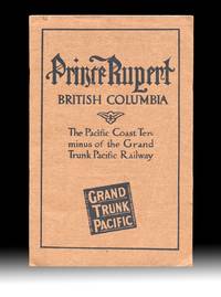
19114499Montreal QC: The Grand Trunk Pacific Railway Company 1911. Paperback. Fine. With "Fourth Edition April 1911" printed at foot of the "Announcements" page giving a good indication of the amount interest that the new terminal town and surrounding areas were generating at the time. Includes two fold-out maps one tipped in at title page and the other a real lithographic beauty and excellent promotional map is in color and tipped in at the rear with an additional two insert maps in it's corners. Both maps are in very fine condition. Brown printed wraps 8vo size 9.25 inches tall pp. 24 illustrated w. B&W photo reproductions showing the current stage of development of the town harbor and their surrounds with some images dated "September 1910" table of summit elevations and rwy grades on verso of terminal leaf. Volume w. a touch of rust to staples one leaf w. two light creases and a 1/4 inch closed tear at fore-edge else clean and unmarked throughout. The large color map at rear 33.5 x 26 inches wide is titled "Map Of The Grand Trunk Pacific Railway In British Columbia Showing Terminus At Prince Rupert" plate mark "4824" at lower left and has a copyright date of 1907 by Poole Bros. An additional date of "4-10-'11" is printed at the lower edge matching the pub. date of "Fourth Edition April 1911" printed on the "Announcements" page. These matching dates would have confirmed for potential investors and settlers that the map and pamphlet had the most up to date information available at the time. The two insert maps are "Map Of Price Rupert And Vicinity" and "Latitude Map". The frontis map 9x17 inches wide is titled "General Plan for the Development of Prince Rupert B.C. and was executed by Brett & Hall Landscape Architects Boston who used "City Beautiful" principles with success in Smithers and Fort Prince George as well. Evidently most of the Prince Rupert today is based upon this Brett & Hall plan. OCLC finds no copies of this 1911 edition of this GTPR pamphlet. Rumsey's copy of the large color map lacking the pamphlet and the frontis map is dated "3-28-'10 The Grand Trunk Pacific Railway Company paperback
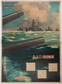
1619176888東京. Tokyo.: 東京日日新聞社. Tōkyō Nichinichi Shinbunsha. Showa 16 1941. Colour poster from a 1941 calendar. 53.5 x 38.5cm small holes at corners central horizontal fold. Some light even browning but overall a striking WWII image from a Japanese calendar. This colour illustrated calendar shows the months of March April and May 1941. The illustration features four Japanese war ships at sea with two naval guns in the foreground. The calendar is titled "Rough Sea on the Pacific Ocean". The implication being military threats are coming from across the Pacific. . 東京日日新聞社. [Tōkyō Nichinichi Shinbunsha]. unknown
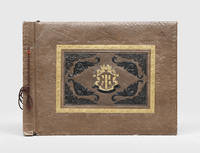
1940182459Manila: 1940s. A graphic album showing fighting in the Philippines the Marshall Islands Papua New Guinea Guam the Solomon Islands and Palau. The compiler chose to include violent images displaying the brutality of the campaign. The album opens with portrait shots of individual Marines or groups along with photographs of American encampments and ships. The scenes then turn more distressing with images of dead locals including children lying on the beach or next to tanks. The photographs were taken across the Pacific theatre: one shows an American soldier holding a flame-thrower on Kwajalein Atoll another shows a beach landing at Luzon and a third shows a Marine posing next to a sign in Bougainville. Most were taken in the final years of the conflict including at Guadalcanal and Peleliu. There are also shots of the end of the war one showing a Japanese soldier surrendering with a white flag and another showing Japanese prisoners of war in a camp in Guam. The final photograph is the most famous "Raising the Flag on Iwo Jima" showing six Marines raising the US flag on Mount Suribachi during the Battle of Iwo Jima. This photograph won the 1945 Pulitzer Prize for Photography. The majority of the photographs are commercial with a few opening portrait shots of the unidentified compiler. Oblong folio 286 x 390 mm. With 55 gelatin silver photographs one lacking approximately 90 x 130 mm landscape or portrait corner-mounted with tape recto and verso on 7 leaves remainder blank. With 2 additional gelatin silver photographs loosely inserted. Contemporary brown sheep commercial album tied through punched holes with brown cord front board stamped with central armourial panel in blind gilt and black. Boards chipped at extremities especially front board bottom left corner rear board rubbed leaves nicked at fore edge photographs moderately toned and creased some slightly torn and abraded: a good example. hardcover
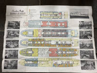
194849014Montreal Canada & Liverpool UK: Canadian Pacific n.d. ca 1948. ca 1948. First edition. Double Atlas Folio. 30 3/4" x 41" folded to 5 1/4" x 10 1/4." Illustrated on recto and verso with 6 large color deck plans delineating decks amenities cabins for first class and tourist class passengers together with black and white photo illustrations. Scarce deck plan for the Empress of Canada SS Duchess of Richmond and the Empress of France SS Duchess of Richmond after the two 20400 tons ocean liners had been refitted following World War II. Initially launched as the "Mini-Empresses" but also referred to as the "Drunken Duchesses" as they tended to roll in heavy seas. They were designed to allow travelers to sail further up the St. Lawrence River to Montreal as well as to those wishing to travel into the Great Lakes. The ships were fitted with enough capacity to hold 400 first class passengers and 300 tourist class passengers. The ships entered service from Liverpool to Montreal in July 1947 and September 1948 respectively. Sadly the Empress of Canada caught fire in 1953 and after re-floating was scrapped in Italy the following year. The Empress of France was refitted in 1958/1959 and continued to sail until retired in 1960. Some age toning slight closed tear at one fore-edge and with creasing at folds. Very good. Canadian Pacific, n.d. [ca 1948]. unknown
18851099Chicago: Geo. F. Cram 1885. Good plus. Large folding pamphlet approximately 20 x 41.5 inches. A few small chips and short closed tears at edges; several short separations and very minor losses along folds. Contemporary agent's ink stamp on cover panel. Tape repair across portion of horizontal fold; one panel with patches of light staining. A scarce colorful promotional for the Rock Island Route as well as its national and international connections with a fascinating stamp of an Australian sales agent. One side of the sheet prints an extensive promotional text and timetables for the various routes and services of the Chicago Rock Island & Pacific Railway. The main side of the sheet prints a map of the United States with state borders shaded in four colors highlighting the principal routes of the Rock Island from Chicago to Minnesota Iowa and Kansas and its connections to points on both the East and West Coasts. An inset map at lower right promotes the Rock Island as part of a transcontinental route between the United Kingdom Ireland and Australia. Most interestingly this copy is stamped on the cover panel with the information of a George. H. Hibbard "Australian Passenger Agent America's Cons'd Trans-continental Railways 6 Bridge Street Sydney N.S.W." Hibbard was evidently the agent in charge of distributing information about the trans-America route in Sydney one of its end points.<br /> <br /> Several issues of this map were published during the 1880s all scarce. We locate copies of the present 1885 issue at Stanford SMU and the Library of Congress. Geo. F. Cram unknown
18571004304to 11 ½ x8 ¾ original law calf morocco illustrated 4 134 85102 114 2 iv 64 pp. Some scuffing and wear to covers slight gouge to front joint chipping to edges. Two plates detached one with a chipped corner. Overall very good. Organized by the War department under the direction of Jefferson Davis who was Secretary of War at that time a collection of volumes was produced in the quest for the best route for a railroad to the West. Jefferson Davis wrote part of the introduction to this series and outlines the goals of the project. This report is on routes explored in Northern California and Oregon. Specifically the expedition was to look for a railroad route crossing the Sierra Nevada near the source of the Carson River and to see if it was feasible to connect the Sacramento valley with the Oregon Territory. Most of the color plates in this volume are located in the first three parts of the publication which is focused on topography geology and botanical subjects. This volume includes 23 color lithographs of scenery and botanical subjects 2 hand colored plates of birds and 24 steel engraved plates. Wagner-Camp 264a. Beverly Tucker, unknown
18561006214to leather spine and tips with marbled boards 36 Illustrations include 21 tinted/color lithographs one folding diagram two folding maps and a couple of black and white plates 36 14 136 127 175 pp. Binding with some wear at the spine and extremities hinges cracked some pages are a bit loose plates all present but probably not bound in correct order folding maps have a few tears some staining to front endpapers but not into the balance of the text plates and text show some aging foxing and browning but most plates resonably are clean. One of the great sources of information on the west the Pacific Railroad Reports also contains some great illustrations. This installment Vol. III is no exception. Included are some interesting and colorful pictures of the Mojave Indians and their territory. This report contains intelligence on an expedition near the 35th parallel which took the southern route due west to the Pacific Ocean from Fort Smith Kansas that was conducted by Lieutenant A.W. Whipple and assisted by Lieutenant J.C. Ives. Ives would make his own mark on western expansion a few years later in his travels on the Colorado River. The substantial amount of information on various Indain tribes makes this installment an important one. Since many of these volumes are broken for the plates they are getting somewhat scarce. Beverly Tucker, hardcover
17512342048Venezia: Presso Francesco Pitteri Con Licenza de' Superiori e Privilegio 1751. Revised Edition. Hard Cover. Very Good/No Jacket. Revised edition. Rebound with new endpapers. Minor ink notes on flyleaves modern owner bookplate on front endpaper of each volume. 1751 Hard Cover. 12 310; 406 pp. 12mo. Cloth spines gilt titles paper over boards. Italian text. An 18th century guide to Venice by Pietro Antonio Pacifico with engraved illustrations including several fold-outs. Presso Francesco Pitteri, Con Licenza de' Superiori, e Privilegio hardcover
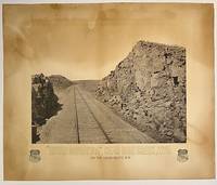
187510295Boston: Heliotype Printing 1875. Heliotype 38 cm x 48 cm on cream colored stock 55 cm x 66 cm with printed title and credit. Overall age toning. Heliotype promoting the Union Pacific line with a view of the tracks crossing Sherman Hill and the Continental Divide outside of the now ghost town of Sherman Wyoming. Sherman Hill is one of the landmarks on the transcontinental railroad and the highest point on the original U.P. line with a summit topping of 8247 feet above sea level. Sherman Hill is one of the easiest crossings of the Rockies and today it is one of the busiest lines. We are unable to locate another example of this poster. Rare. Heliotype Printing unknown